Arkiv - dato
Arkiv - aktivitet
-
Annen tur (1)
- Kajakkpadling (1)
-
Annen vintertur (4)
- Trugetur (4)
- Fottur (740)
-
Skitur (4)
- Fjellskitur (4)
-
Sykkeltur (137)
- Blandet sykling (51)
- Gatesykling (9)
Arkiv - Etter geografi
"Peakbookvenner"


Lister jeg samler etter
-
Bergen ≥ 50m pf. og ≥ 100 m.o.h.
(87/89)
 97%
97% -
Most dominating tops of the Bergen peninsula
(68/75)
90%
-
Utvalgte topper og turmål i Bergen
(316/350)
90%
-
Alle topper i Bergen
(357/398)
89%
-
Opptur Bergen
(100/113)
88%
-
De syv fjell rundt Bergen
(6/7)
85%
-
Sund ≥ 50m pf.
(14/18)
77%
-
Os ≥ 50m pf.
(25/34)
73%
-
Søyler (fastmerker) i Bergen
(68/100)
68%
-
Fjell ≥ 50m pf.
(21/32)
65%

Biking Askøy with Dyrdalsfjellet
- Dato:
- 15.05.2026
- Turtype:
- Blandet sykling
- Turlengde:
- 4:00t
- Distanse:
- 38,2km
 After work, we still wished to get out and thus decided to make a bike-trip to Askøy. After following the main bike-route to Askøy, which follows first Kjøkkelvikveien, north of Loddefjord, before then continuing along Sundby Hvorups vei to connect to the large bridge, we then cycled up Stongafjellsvegen to get up to the south of Dyrdalsfjellet. In fact, it was possible to bike almost all the way up and we "only" had a few height meters left to walk, after leaving our bikes behind on the saddle in the south of Dyrdalsfjellet. After first enjoying the views from Dyrdalsfjellet, we then included also Varden at Øvre Kleppe for some more nice views. Once back to the bikes, we decided that we could make a round via Erdalen before heading back. We therefore continued to bike in >>>
To Alvøen and back
- Dato:
- 14.05.2026
- Turtype:
- Blandet sykling
- Turlengde:
- 1:30t
- Distanse:
- 26,2km
 We thought that it would be interesting to have another look at the progress of the construction of the new bridge to Sotra. We thus took our bikes and headed into the direction of Alvøen. At Hetlevikstraumen, we used the small bridge to get over to the western side of Mathopsvågen. At Mathopen, we then took a turn to the right in order to connect to Småvatnet a bit further north. Biking along Småvatnet, we then connected to Hakonshellaveien. From there, we then descended to the old main building of Alvøen. On the other side of Alvøen, the continuation was then along Pålaveien and Ramsvikveien further northwards. At Janaveien, the new bridge came into view, first, and from Janahaugen one could enjoy a nice close-up view. Also from the other side, at Drotningsvikveien, looking >>>
To Åsane via Bergen and back
- Dato:
- 07.05.2026
- Turtype:
- Gatesykling
- Turlengde:
- 2:30t
- Distanse:
- 56,1km
 I had something to do in Åsane and thus decided to extend my bike to trip to Bergen by a detour via Åsane. On my way back, I included a traverse via Munkebotn (instead of cycling around Eidsvågsneset again) and Fjellveien.
See also the related FB-page Hiking around Bergen, Norway .
On web page prominent-mountains.no , there's a [xxx|useful page about Xxx].
Similarly, on web page WestCoastPeaks.com , there's also a [xxx|useful page about Xxx].
I had something to do in Åsane and thus decided to extend my bike to trip to Bergen by a detour via Åsane. On my way back, I included a traverse via Munkebotn (instead of cycling around Eidsvågsneset again) and Fjellveien.
See also the related FB-page Hiking around Bergen, Norway .
On web page prominent-mountains.no , there's a [xxx|useful page about Xxx].
Similarly, on web page WestCoastPeaks.com , there's also a [xxx|useful page about Xxx].
Bike-hiking Fanafjellet
- Dato:
- 03.05.2026
- Turtype:
- Blandet sykling
- Turlengde:
- 5:00t
- Distanse:
- 42,3km
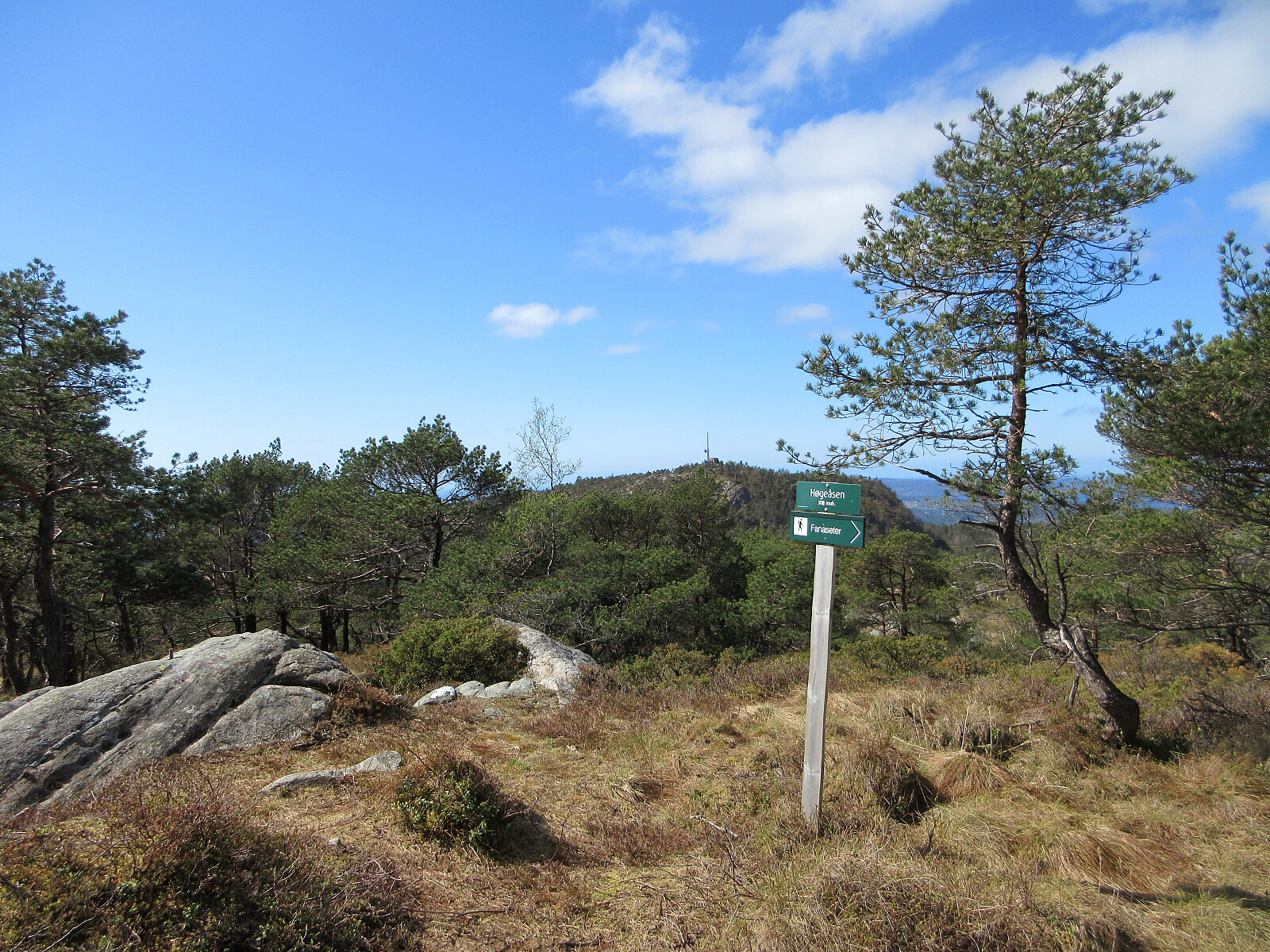 We decided to combine biking and hiking, heading to Fanafjellet with our bikes. Leaving our bikes behind at Fanasæter, we then hiked the one round on Fanafjellet, which includes Høgeåsen and Lyseskarfjellet (Linken), returning via Ramberget to Fanasæter. On our way back, we then included a short detour via Fanahammeren, before then cycling around Hordnesskogen. From Grimseidvegen, we then crossed through Skageskogen to get to Øvre Birkeland. From there, it was then along Ytrebygdsvegen back. Nice to comine biking and hiking on such a nice day! :-)
Selected photos are available as Google photo album .
See also the related FB-page Hiking around Bergen, Norway .
On web page WestCoastPeaks.com , there's a useful page about Lyseskarfjellet and Høgeåsen .
We decided to combine biking and hiking, heading to Fanafjellet with our bikes. Leaving our bikes behind at Fanasæter, we then hiked the one round on Fanafjellet, which includes Høgeåsen and Lyseskarfjellet (Linken), returning via Ramberget to Fanasæter. On our way back, we then included a short detour via Fanahammeren, before then cycling around Hordnesskogen. From Grimseidvegen, we then crossed through Skageskogen to get to Øvre Birkeland. From there, it was then along Ytrebygdsvegen back. Nice to comine biking and hiking on such a nice day! :-)
Selected photos are available as Google photo album .
See also the related FB-page Hiking around Bergen, Norway .
On web page WestCoastPeaks.com , there's a useful page about Lyseskarfjellet and Høgeåsen .
A nice day in Wien
- Dato:
- 01.05.2026
- Turtype:
- Blandet sykling
- Turlengde:
- 2:00t
- Distanse:
- 9,3km
 We used this nice day to first bike to Karlsplatz, where we visited Albertina Modern and the KAWS exhibition there. Thereafter, we crossed through the first district of Vienna, also enjoying the world's best icecream at Tuchlauben, before then biking along Donaukanal to get back. Very nice! :-)
See also the related FB-page Hiking around Bergen, Norway .
We used this nice day to first bike to Karlsplatz, where we visited Albertina Modern and the KAWS exhibition there. Thereafter, we crossed through the first district of Vienna, also enjoying the world's best icecream at Tuchlauben, before then biking along Donaukanal to get back. Very nice! :-)
See also the related FB-page Hiking around Bergen, Norway .
Through Wien from Hauptbahnhof
- Dato:
- 29.04.2026
- Turtype:
- Gatesykling
- Turlengde:
- 0:45t
- Distanse:
- 9,4km
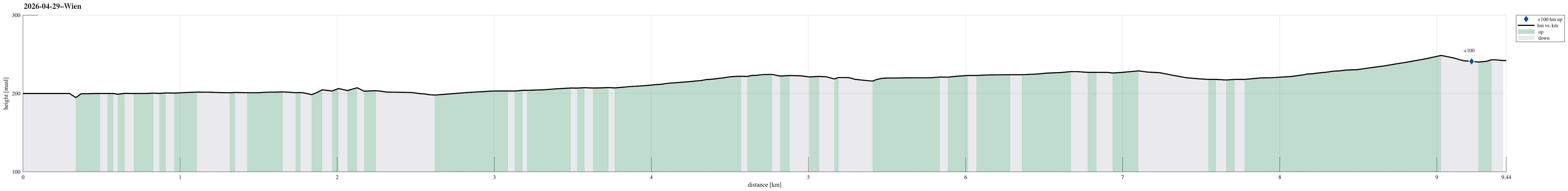 After first biking from Smolenice to Marchegg and then taking a train to Vienna, I still had to cover some 10km in Vienna. This worked as planned and there's nothing special to report about the route.
See also the related FB-page Hiking around Bergen, Norway .
After first biking from Smolenice to Marchegg and then taking a train to Vienna, I still had to cover some 10km in Vienna. This worked as planned and there's nothing special to report about the route.
See also the related FB-page Hiking around Bergen, Norway .
Biking from Smolenice to Marchegg
- Dato:
- 29.04.2026
- Turtype:
- Blandet sykling
- Turlengde:
- 3:45t
- Distanse:
- 69,6km
 After lunch, I made myself ready for another bike-trip: this time in the northwest of the Carpartian mountains back to Austria. For the third time in three days, I headed first westwards (and into the Carpartian mountains), following the forest road south of Havranica and Záruby. While this forest road is really nice near Smolenica castle, it gets a bit more rough a bit further west (and higher up in the mountains). Still, it was straight-forward to traverse it, even with all the luggage. The descent on the other side, to Plavecký Mikuláš, was partly quite steep, but cycling down there was still possible without real difficulties. I then cycled along road 501 which brought me through Sološnica and Rohožník to Pernek. Further down the same road, I then arrived in Lozorno. South >>>
To Smolenice via Molpír
- Dato:
- 28.04.2026
- Turtype:
- Fottur
- Turlengde:
- 1:30t
- Distanse:
- 6,5km
 In order to have something to drink on my bike-trip back from Smolenice the next day, I wished to visit the small store in Smolenice during the day. In order to get there, I decided to make a short detour that would bring my to Smolenice over Molpir, known for its historic site(s). I first followed the same forest road as on my hike to Záruby the day before, while turning left this time at the first saddle. Within a few steps, I then arrived at the ridge which would bring me to Molpir, following it in eastward direction. While walking along the ridge, I got to enjoy some nice views from the top of several small southfacing cliffs. I even got to see a small cave. Once past the historic site on Molpir, I started my descent to Smolenice. Instead of aiming at the road a bit further north, I continued along the ridge. >>>
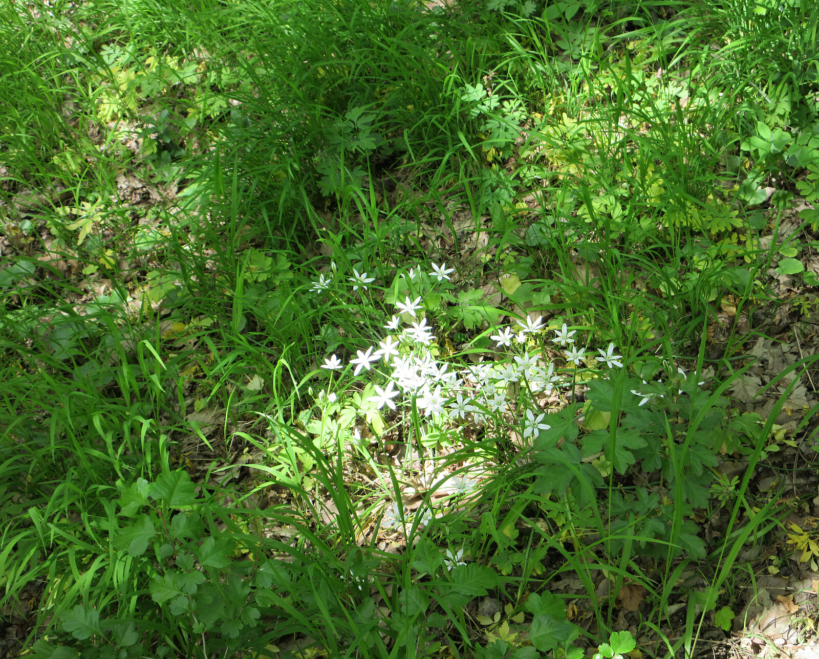
Záruby and Havranica from Smolenice castle
- Dato:
- 27.04.2026
- Turtype:
- Fottur
- Turlengde:
- 2:15t
- Distanse:
- 8,2km
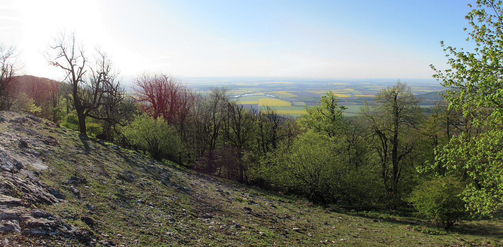 Before breakfast, I woke up early and decided that the day was simply to nice to not get out and attempt a walk or hike. Heading westwards and into the Carpartian mountains right next to Smolenice, I first followed a nice forest road with a gentle inclination. Near the first saddle, I then decided that I could try to reach Záruby, a bit further in the northwest. The trail there was nice (and steep), but within a bit more than one hour, after departing from the castle, I found myself on top of the east-west oriented ridge, right east of the top of Záruby. After quickly visiting the very top, I then followed the ridge "back" (in eastward direction) to also include Havranica on my way back. After stepping over Havranica, I found a nice vista point with a great view towards the >>>
Biking from Bratislava to Smolenice
- Dato:
- 26.04.2026
- Turtype:
- Blandet sykling
- Turlengde:
- 6:00t
- Distanse:
- 76,7km
 After first biking through Vienna , I then took the boat (TwinCityLiner) from Vienna to Bratislava. From there, I had planned to bike to Smolenice in the northeast of Bratislava, following the southeastern feet of the Carpartian mountains. After arriving between the SNP bridge and Starý (old) bridge, I first had to find my way through Bratislava. Relatively soon, I found myself on Špitálska, before then continuing on Krížna and Vajnorská towards the northeast. Since it was Sunday in the morning, the traffic was limited and biking along these major roads was just fine. I then took a turn left onto Jarošova, before soon turning right, again (onto Racianska). Following Racianska, which is one of the main roads out of Bratislava towards the north, I quickly made the necessary kilometers to get out of Bratislava. >>>
