Arkiv - dato
Arkiv - aktivitet
-
Annen tur (1)
- Kajakkpadling (1)
-
Annen vintertur (4)
- Trugetur (4)
- Fottur (740)
-
Skitur (4)
- Fjellskitur (4)
-
Sykkeltur (137)
- Blandet sykling (51)
- Gatesykling (9)
Arkiv - Etter geografi
"Peakbookvenner"


Lister jeg samler etter
-
Bergen ≥ 50m pf. og ≥ 100 m.o.h.
(87/89)
 97%
97% -
Most dominating tops of the Bergen peninsula
(68/75)
90%
-
Utvalgte topper og turmål i Bergen
(316/350)
90%
-
Alle topper i Bergen
(357/398)
89%
-
Opptur Bergen
(100/113)
88%
-
De syv fjell rundt Bergen
(6/7)
85%
-
Sund ≥ 50m pf.
(14/18)
77%
-
Os ≥ 50m pf.
(25/34)
73%
-
Søyler (fastmerker) i Bergen
(68/100)
68%
-
Fjell ≥ 50m pf.
(21/32)
65%

Morning round on Ryvardsneset
- Dato:
- 16.11.2024
- Turtype:
- Fjelltur
- Turlengde:
- 1:30t
- Distanse:
- 3,9km
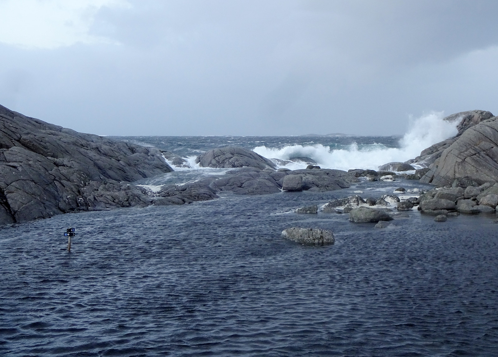 We were staying in one of Flokehyttene on Ryvardsneset and given the rather strong winds the circumstances for easily sleeping into the Saturday were not ideal anyway -- instead, it was much better to get out into the wind and make an attempt to use a rain-free period for a stroll around Ryvardsneset. First, we took the few steps out to the light house at Ryvarden. With all the rather strong winds, it was clearly an impressive experience (and walking down to Huldrahola was by no means a viable option). Next, we visited the commemoration monument for the Sleipner tragedy a bit north of Ryvarden in 1999. Even though breakfast was tempting a real lot, already, there still seemed to be a good opportunity for including a short trail along the southern coast of Ryvardsneset. This trail, when >>>
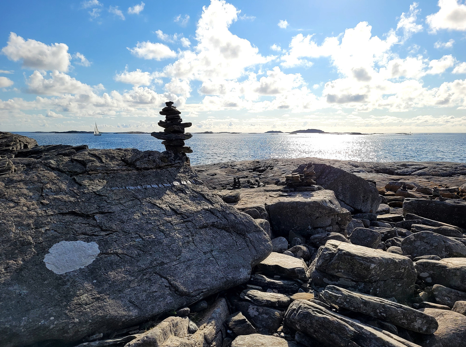
Exploring (parts of) Lysøya
- Dato:
- 28.07.2024
- Turtype:
- Fjelltur
- Turlengde:
- 2:30t
- Distanse:
- 4,2km
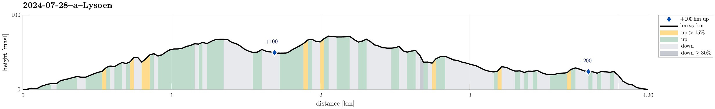 Even though we knew that Ole Bulls villa would be closed, we still thought that making an excursion to Lysøya could be nice. The ferry took us over to Lysøya from Buena and we started our walk with taking a look at Ole Bulls villa (from the outside, only). From there, we then continued southwards (and upwards) to take a look at a small vista-point ("Udsigten"), before then continuing northwards (and via the heights of Lysøya). This then brought us to the little watch tower ("Tårnet") from which one indeed can enjoy some nice views (over the tree-tops). Thereafter, we walked further northwards in order to take a look at Furulunden (also the highest point on Lysøya). Next on our "ToDo list" was Lysøygrotta, just a little underneath Furulunden (in its west). >>>
Gløvrebu
- Dato:
- 27.07.2024
- Turtype:
- Fjelltur
- Turlengde:
- 1:30t
- Distanse:
- 2,6km
 After our excursion to Skogsøyna , we decided to also see "the split rock" at Gløvrebu. We parked right next to the cemetary of Hjelme church on Seløyna and followed the main trail out to Gløvrebu, choosing the variant that brings one out to the sea early. At Gløvrebu, we then stepped through the gap in the rock -- as one obviously has to! :-) -- before enjoying the early evening near the coast for some time. To get back to our car, we then followed the trail that "hugs" Ramberget (in the west of Hjelme church).
Selected photos are available as Google photo album .
See also the related FB-page Hiking around Bergen, Norway .
Web page UT.no from the Norwegian Trekking Association recommends a similar hike .
After our excursion to Skogsøyna , we decided to also see "the split rock" at Gløvrebu. We parked right next to the cemetary of Hjelme church on Seløyna and followed the main trail out to Gløvrebu, choosing the variant that brings one out to the sea early. At Gløvrebu, we then stepped through the gap in the rock -- as one obviously has to! :-) -- before enjoying the early evening near the coast for some time. To get back to our car, we then followed the trail that "hugs" Ramberget (in the west of Hjelme church).
Selected photos are available as Google photo album .
See also the related FB-page Hiking around Bergen, Norway .
Web page UT.no from the Norwegian Trekking Association recommends a similar hike .
Evening walk to Knappen
- Dato:
- 26.07.2024
- Turtype:
- Fjelltur
- Turlengde:
- 1:30t
- Distanse:
- 4,5km
 With still a couple of daylight hours to go (easy in July around here!), we decided to simply make a short round to Knappen. Evening light is actually quite nice -- also on Knappen! :-)
Selected photos are available as Google photo album .
See also the related FB-page Hiking around Bergen, Norway .
Petter Bjørstad has a useful page about Knappen .
Web page UT.no from the Norwegian Trekking Association recommends another hike to Knappen .
With still a couple of daylight hours to go (easy in July around here!), we decided to simply make a short round to Knappen. Evening light is actually quite nice -- also on Knappen! :-)
Selected photos are available as Google photo album .
See also the related FB-page Hiking around Bergen, Norway .
Petter Bjørstad has a useful page about Knappen .
Web page UT.no from the Norwegian Trekking Association recommends another hike to Knappen .
Prozor from Arapovac
- Dato:
- 10.07.2024
- Turtype:
- Fjelltur
- Turlengde:
- 2:00t
- Distanse:
- 2,4km
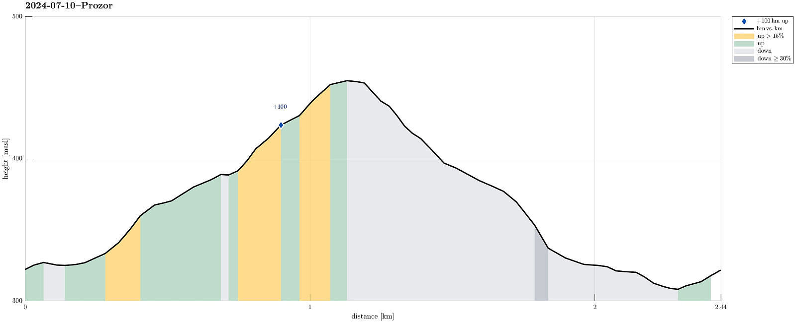 We were up for a short hike, given the quite hot weather. From Arapovac, we made our way up to Prozor, mostly without any trail. To get back to Arapovac, we chose another route, also (partly) without any (proper) trail. Hiking in those parts, which are covered by some older forest, was nice and without challenges; hiking through newer forest, however, was challenging due to the extra-dense vegetation! :-)
Selected photos are available as Google photo album .
See also the related FB-page Hiking around Bergen, Norway .
We were up for a short hike, given the quite hot weather. From Arapovac, we made our way up to Prozor, mostly without any trail. To get back to Arapovac, we chose another route, also (partly) without any (proper) trail. Hiking in those parts, which are covered by some older forest, was nice and without challenges; hiking through newer forest, however, was challenging due to the extra-dense vegetation! :-)
Selected photos are available as Google photo album .
See also the related FB-page Hiking around Bergen, Norway .
Knappen
- Dato:
- 02.06.2024
- Turtype:
- Fjelltur
- Turlengde:
- 0:45t
- Distanse:
- 4,8km
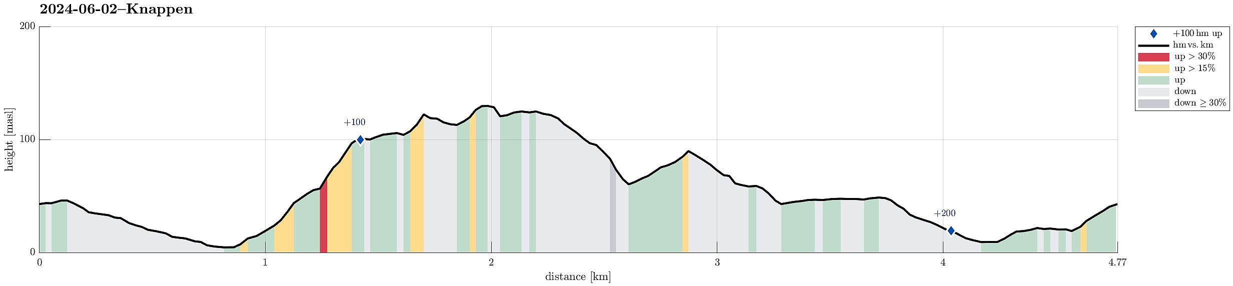 To get some fresh air, we decided to do a quick round over Knappen, approaching it via Sandeidbrotet (up to Eldtona, first). After crossing over to Såta on Knappen, we then descended furthre southwards (via Hesthaugen). Before stepping out on Knappenveien, we saw some (new?) signs near the sports area, suggesting a trail through the forest to Knappentunet. Following this trail, we first made quick progress into the right direction. After a while, however, the trail seemed to cross over some wet area at Hesthaugen, becoming less visible (or not at all, actually). Following our basic sense of orientation, we crossed through the forest into the right direction, connecting to Knappenveien at Knappentunet in the south of Knappatjørna. From there, it was then straight-forward (mostly) to >>>
Bekhilderen at low tide
- Dato:
- 20.04.2024
- Turtype:
- Fjelltur
- Turlengde:
- 3:00t
- Distanse:
- 6,8km
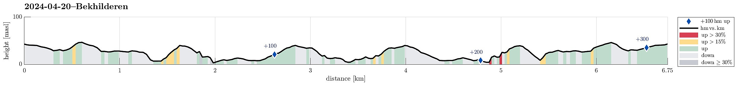 Planning our timing just right, we decided to visit Bekhilderen at low tide. We parked along Telavågvegen and followed first the road Håvarden. This brought us to the old mill at Selståvågen. From there, we followed the trail first to Grunnevågen and then further, on the other, southern side, to Bekhilderen. After having some good time there, we returned, basically following the same route "backwards". :-)
Selected photos are available as Google photo album .
See also the related FB-page Hiking around Bergen, Norway .
Web page UT.no from the Norwegian Trekking Association recommends a similar hike .
Planning our timing just right, we decided to visit Bekhilderen at low tide. We parked along Telavågvegen and followed first the road Håvarden. This brought us to the old mill at Selståvågen. From there, we followed the trail first to Grunnevågen and then further, on the other, southern side, to Bekhilderen. After having some good time there, we returned, basically following the same route "backwards". :-)
Selected photos are available as Google photo album .
See also the related FB-page Hiking around Bergen, Norway .
Web page UT.no from the Norwegian Trekking Association recommends a similar hike .
Walk around Sælevatnet
- Dato:
- 14.04.2024
- Turtype:
- Fjelltur
- Turlengde:
- 2:00t
- Distanse:
- 9,6km
 This time, the plan was to walk around Sælevatnet. I started from Varden and headed towards Bondegården in the north of Sælevatnet, first. I the surrounded Bondegården in its south (around Neset). On the other side, I then followed Sælenveien southwards, before I turned left to enter Stokkedalen via Løtveitveien. Looking east, I wondered whether it is possible to ascent towards Barhaugen via its very steep western flank. North of house #90 in Stokkedalen, I then found an opportunity to get up (not really a trail, but it looked as if others had done this before, still). This brought me up to Rekdalsveien, which I then followed southwards in order to connect to Barhaugen. At house #95, however, there's no way to proceed; I thus had to "go around" via Fjellsdalen. This >>>
Spelhaugen from Varden
- Dato:
- 05.04.2024
- Turtype:
- Fjelltur
- Turlengde:
- 2:00t
- Distanse:
- 6,1km
 I had to get something from Spelhaugen and decided to walk there through Kanadaskogen.
Selected photos are available as Google photo album .
See also the related FB-page Hiking around Bergen, Norway .
I had to get something from Spelhaugen and decided to walk there through Kanadaskogen.
Selected photos are available as Google photo album .
See also the related FB-page Hiking around Bergen, Norway .
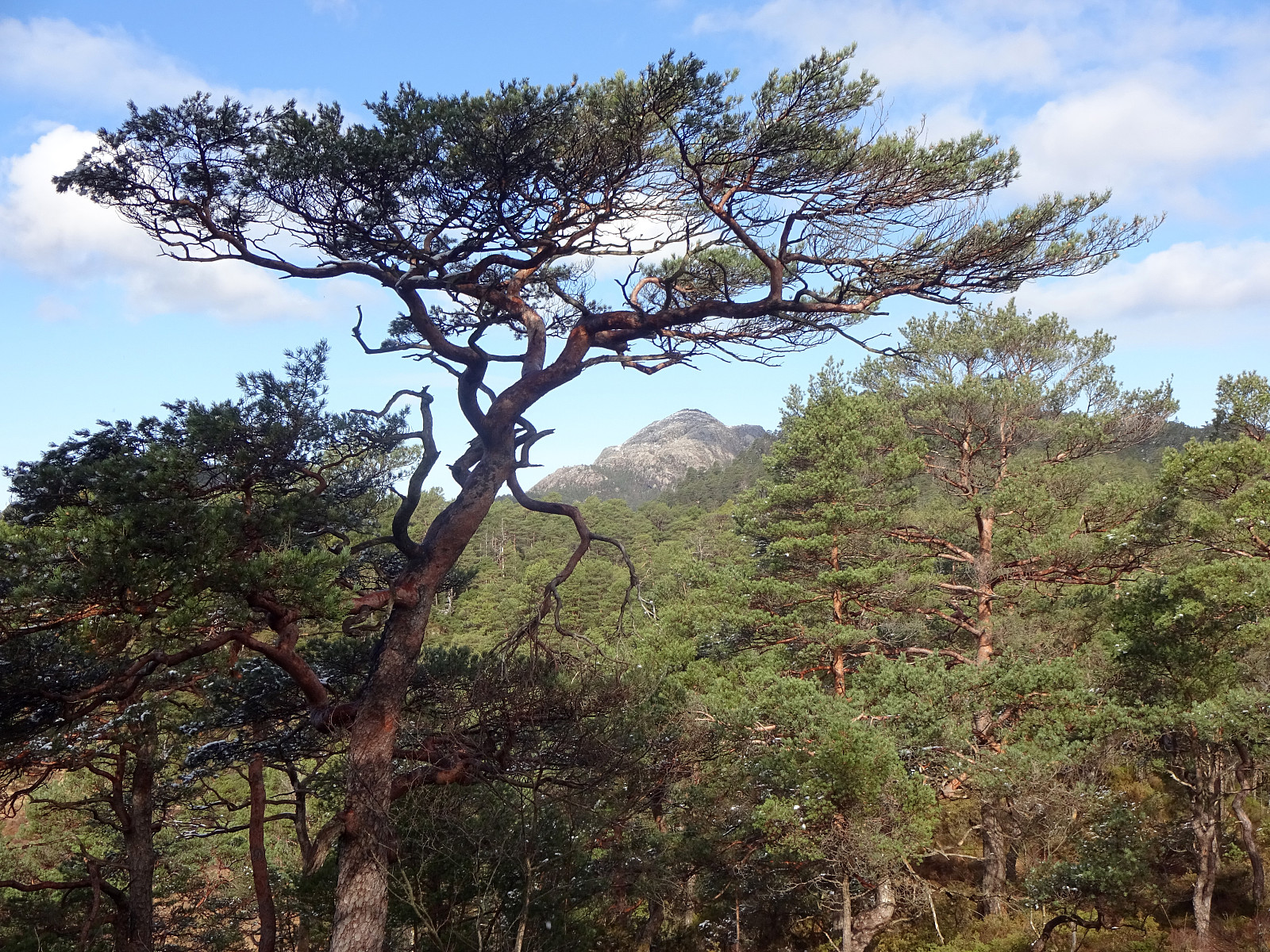
Pyttane in windy weather
- Dato:
- 03.02.2024
- Turtype:
- Fjelltur
- Turlengde:
- 1:30t
- Distanse:
- 6,7km
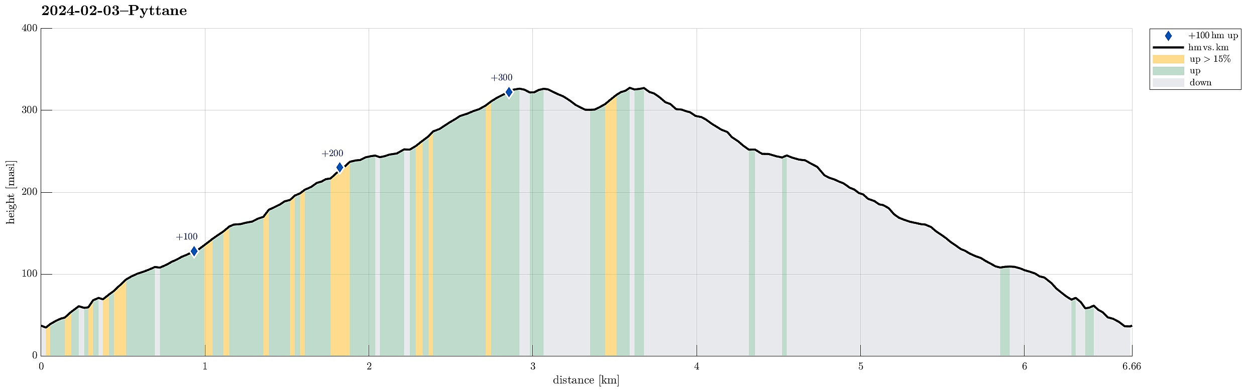 With quite a bit of weather outside, we decided to "just" go up and down Pyttane on Sotra. We took the car to Ekrhovdvegen in the very east of Sotra and parked near Nordre Stølen, where the service road up to Pyttane starts. We then walked up to the radar stations, experiencing significant weather on the top (strong winds, some precipitation). While it was nice to get out into the fresh air, we still did not feel like staying up there "in the elements" for any prolonged time, thus walking back down more or less immediately, again. All in all, this walk up to Pyttane is always nice (and easy), lending itself well to getting some fresh air without an all-too-long trip.
Selected photos are available as Google photo album .
See also the related FB-page Hiking around Bergen, Norway .
Web page WestCoastPeaks.com provides useful information about Liatårnet
and also Petter Bjørstad has a >>>
With quite a bit of weather outside, we decided to "just" go up and down Pyttane on Sotra. We took the car to Ekrhovdvegen in the very east of Sotra and parked near Nordre Stølen, where the service road up to Pyttane starts. We then walked up to the radar stations, experiencing significant weather on the top (strong winds, some precipitation). While it was nice to get out into the fresh air, we still did not feel like staying up there "in the elements" for any prolonged time, thus walking back down more or less immediately, again. All in all, this walk up to Pyttane is always nice (and easy), lending itself well to getting some fresh air without an all-too-long trip.
Selected photos are available as Google photo album .
See also the related FB-page Hiking around Bergen, Norway .
Web page WestCoastPeaks.com provides useful information about Liatårnet
and also Petter Bjørstad has a >>>
