Arkiv - dato
Arkiv - aktivitet
-
Annen tur (1)
- Kajakkpadling (1)
-
Annen vintertur (4)
- Trugetur (4)
- Fottur (740)
-
Skitur (4)
- Fjellskitur (4)
-
Sykkeltur (137)
- Blandet sykling (51)
- Gatesykling (9)
Arkiv - Etter geografi
"Peakbookvenner"


Lister jeg samler etter
-
Bergen ≥ 50m pf. og ≥ 100 m.o.h.
(87/89)
 97%
97% -
Most dominating tops of the Bergen peninsula
(68/75)
90%
-
Utvalgte topper og turmål i Bergen
(316/350)
90%
-
Alle topper i Bergen
(357/398)
89%
-
Opptur Bergen
(100/113)
88%
-
De syv fjell rundt Bergen
(6/7)
85%
-
Sund ≥ 50m pf.
(14/18)
77%
-
Os ≥ 50m pf.
(25/34)
73%
-
Søyler (fastmerker) i Bergen
(68/100)
68%
-
Fjell ≥ 50m pf.
(21/32)
65%

A round west of Arna, including Stikka
- Dato:
- 27.03.2021
- Turtype:
- Fjelltur
- Turlengde:
- 3:00t
- Distanse:
- 8,5km
 With the perspective of a half-dry, half-wet day ahead of us, we decided for another hike not too far from home. This time, our goal was to explore the hills in the west of Arna and Arnavågen. We thus left Bergen towards the east, aiming for Mjeldheimskleiva, where we parked just above Kleivadalen (in the west, a bit above Arna). We left the road basically where it crosses the little stream that comes down there from the northwest (and where the power line crosses the street, also). After some only 50 meters parallel to the stream, we started our (short) ascent to Vårheia (more or less directly in northern direction). On our way up there, we deviated a little from the trail and ascended across the southern ridge of Vårheia instead (also coming by a little cabin that can be found in >>>
Stortårnet and Nilskyrkja
- Dato:
- 21.03.2021
- Turtype:
- Fjelltur
- Turlengde:
- 2:00t
- Distanse:
- 7,6km
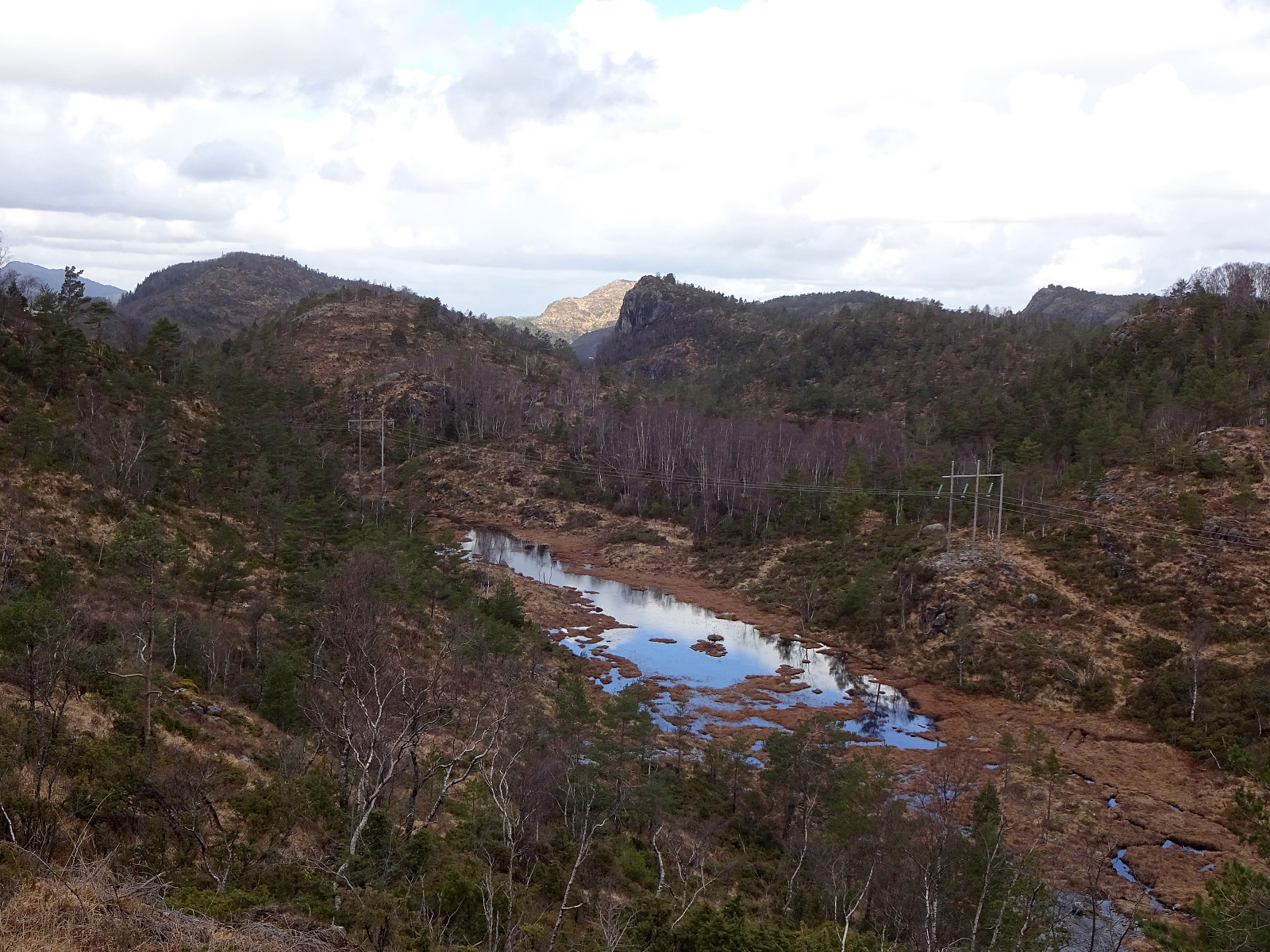
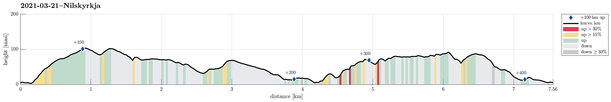 Our idea was to explore the west of Dala, south of Fjell in Øygarden. After driving westwards from Bergen, we turned south once on Sotra. Passing by Fjell, we soon arrived in Dala, where we parked next to the main road. The first (small) hiking goal of the day was Stortårnet in th southwest of Dala. After crossing a playing ground right next to Dalseidet, we started a short ascent (first without any trail). Once above 70mosl, we connected to a simple trail which then lead us to Stortårnet. Before turning back, we first explored the area a little, including the mobile sender mast in the southeast of the top (northwest of Dalatjørna). We then continued northwestwards from Stortårnet, reaching Ærhaugane soon after while walking over the ridge parallel to Trengereidpollen some 75 meters >>>
Lerkhaugen, Lisahaugen, and Gullsteinen
- Dato:
- 21.02.2021
- Turtype:
- Fjelltur
- Turlengde:
- 2:00t
- Distanse:
- 5,1km
 With only a bit of time available, we headed for a short hike in the neighborhood. To include at least one spot of (limited) interest, we decided to aim for Lisahaugen near Langegården in the northeast of Kråkenes. We parked near the southern end of Løvstien (at Øvre Kråkenes) and ascended to Lerkhaugen, first. Thereafter, we crossed Løvstien and continued to Lisahaugen (from its south). Crossing Lisahaugen south-to-north, we came back to Løvstien (for a moment), before changing course, again, and then aiming at Langatjørna in the west of Mindebakken. This ascent from Løvstien is a bit steep, but well possible and actually quite nice through th forest there. North of Langatjørna we then turned around, heading back via Gullsteinen. South of Gullstølen, we descended along some >>>
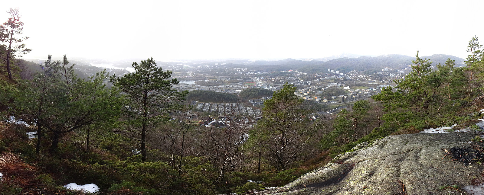
Walk along Sælenvatnet
- Dato:
- 14.02.2021
- Turtype:
- Fjelltur
- Turlengde:
- 1:00t
- Distanse:
- 2,3km
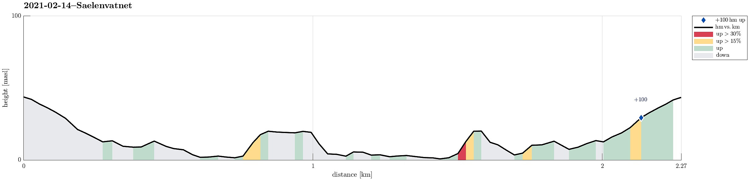 With just a little time at our disposal, we decided to quickly get a little fresh air and make a short walk along the shoreline of (frozen) Sælenvatnet. After walking down from Varden, we crossed over Fyllingsdalsveien, using a small bridge near the big junction with Bjørgeveien. Once on the other side, we walked onto this particular peninsula that extends into Sælenvatnet on its western side. Following some small, but "beaten" paths, we rounded most of this peninsula, before heading back and up to Varden, again. Nice with all that snow! :-)
See also the related FB-page Hiking around Bergen, Norway .
With just a little time at our disposal, we decided to quickly get a little fresh air and make a short walk along the shoreline of (frozen) Sælenvatnet. After walking down from Varden, we crossed over Fyllingsdalsveien, using a small bridge near the big junction with Bjørgeveien. Once on the other side, we walked onto this particular peninsula that extends into Sælenvatnet on its western side. Following some small, but "beaten" paths, we rounded most of this peninsula, before heading back and up to Varden, again. Nice with all that snow! :-)
See also the related FB-page Hiking around Bergen, Norway .
Holefjellet via Storhovden, Eikelifjellet, Gravdalsfjellet
- Dato:
- 13.02.2021
- Turtype:
- Fjelltur
- Turlengde:
- 3:00t
- Distanse:
- 9,3km
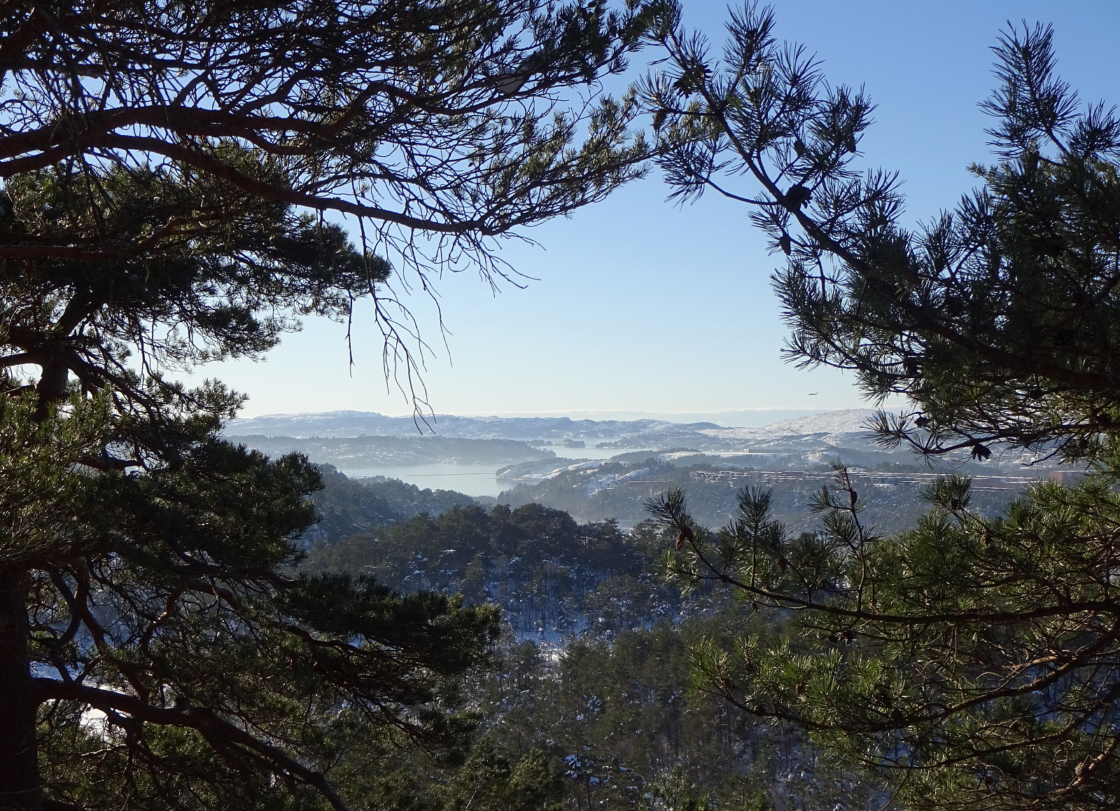 Expecting the unusually stable winter weather to end soon, we decided to get out and enjoy both sun and snow directly where we live, doing "nothing else" than a hike in Kanadaskogen. We started walking northwards from Varden, passing by Sælen church and crossing over the fotball fields in front of the FraMo sports hall, we continued into the direction of Hesjaholten, walking along the houses at Veslefrikkveien in their south. Surrounding Hesjaholten in its west (and below it, there), we entered the valley through which the waters from Krokatjørna come down as a little stream. Walking up this valley, we came to the somewhat more flat (and usually very wet) area in the west of Stora Krokatjørna. Enjoying some lovely sun and nice snow there, we walked across the (usually) boggy >>>
To Ternneset in quite some snow
- Dato:
- 31.01.2021
- Turtype:
- Fjelltur
- Turlengde:
- 3:00t
- Distanse:
- 7,8km
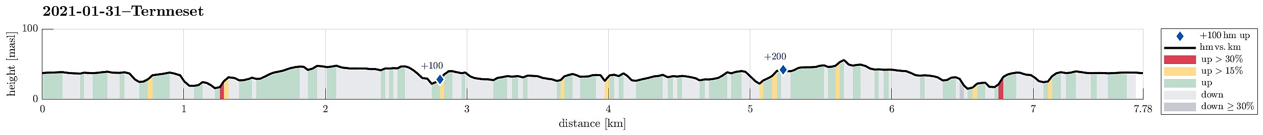 With all the snow around, we aimed at another nice hike out in Øygarden. Expecting that we may end up in not 100% nice weather, we decided to walk out to Ternneset from Kausland. Driving west from Bergen, we turned left (southwards) on Sotra, passing by Fjell soon after and continuing further southwards. After passing Hammarsland, we turned right (in western direction) at Eide. At Vestrepollen, we turn left, again, into the direction of Glesvær. At Kausland, we turned right (onto Liagarden) and parked at the end of the road. From there, we then started our hike in westward direction. Passing by Koldalshaugmyra in its north, we headed further westwards to get through Lauvvatnet (in the north) and Goltatjørna (in the south). North of Hølshaugen, we then crossed to connect to a trail >>>
After work stroll north of Varden
- Dato:
- 21.01.2021
- Turtype:
- Fjelltur
- Turlengde:
- 1:30t
- Distanse:
- 4,2km
 We just wished to refresh ourselves a little after work and thus simply "strolled around" in the neighborhood. The only (very moderately) intersting bit of this short walk was that we tried a new "connection" between Fyllingsdalsveien and Krokatjønnveien, where one can find a good number of trees between the houses, almost a little forest! :-)
See also the related FB-page Hiking around Bergen, Norway .
We just wished to refresh ourselves a little after work and thus simply "strolled around" in the neighborhood. The only (very moderately) intersting bit of this short walk was that we tried a new "connection" between Fyllingsdalsveien and Krokatjønnveien, where one can find a good number of trees between the houses, almost a little forest! :-)
See also the related FB-page Hiking around Bergen, Norway .
Visiting Ånesvika on Algrøyna
- Dato:
- 16.01.2021
- Turtype:
- Fjelltur
- Turlengde:
- 3:30t
- Distanse:
- 8,2km
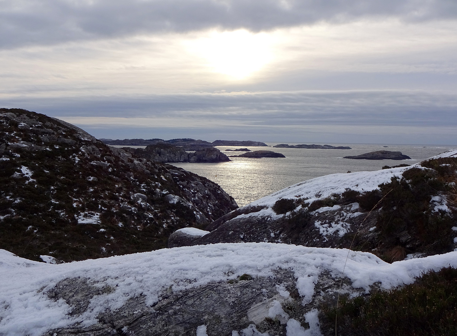 We had heard about a new place for staying overnight in the middle of the wild nature of Algrøyna (at Ånesvika) and thus decided to go and have a look ourselves. :-) After first driving along road 555 towards Sotra in the west of Bergen, we turned towards south after passing through the tunnel in the south of Kolltveit, heading towards Fjell. There, we turned right, again, following road 559 into the direction of Møvik at the west-side of Sotra. Following this road further (eventually northwards along the coast), we came to Skålvik, where we turned left, again, and onto a narrow road leading us to Algrøyna (the road also connects to Langøyna and Lokøyna). Once on Algrøyna, and a little less than half way towards the main village on that island, we parked a bit up the hill, where >>>
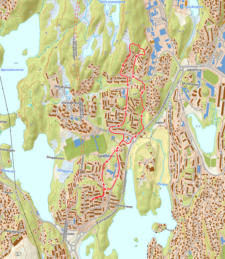
Round around Storavatnet
- Dato:
- 09.01.2021
- Turtype:
- Fjelltur
- Turlengde:
- 1:30t
- Distanse:
- 3,1km
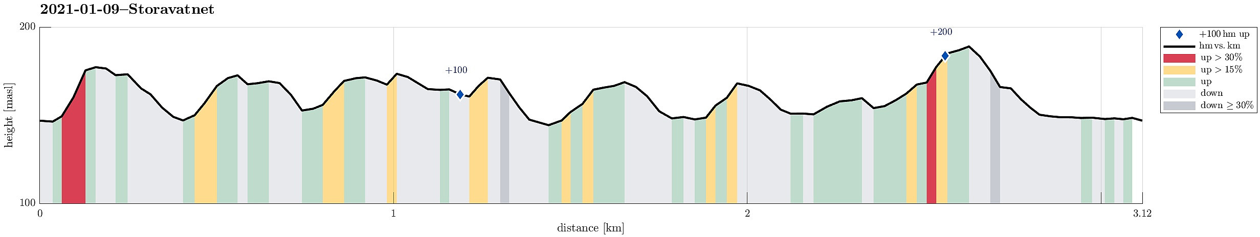 Since there wasn't much daylight left and since the weather was not exactly lovely (it was OK though!), we decided for a short round in the neighborhood. We thus first drove up to Krohnegården in the north of Fyllingsdalen and parked near Svartatjørna. The goal was to make one round aroud Storavatnet (in clockwise direction), but to do that off the main trail. This way, we included a number of small hills, including Søråsen and Nordåsen. From some of them, you actually have some nice views, mostly down into Fyllingsdalen, but also to Løvstakken in the east and Olsokfjellet and Damsgårdsfjellet in the west. While off the main trail, most of this round was still on "minor trails" (and without any difficulties). Only the traverse of the hill in the very northwest of Storavatnet >>>
Nice round through Kanadaskogen
- Dato:
- 02.01.2021
- Turtype:
- Fjelltur
- Turlengde:
- 2:00t
- Distanse:
- 5,9km
 Even though the day was overcast, we still wished to refresh ourselves and thus decided to make a short round through Kanadaskogen. We first walked from Varden to Hesjaholten, following the dead-end road that extends furthest northwards. Almost at the very last house, there's a trail head leading upwards into a small valley in the southeast of Litla Krokatjørna. About half way up into this valley, we turned left and ascended the small hill in the southeast of Litla Krokatjørna. After crossing over it, we descended back into "the small valley", but just to cross it in order to also ascend to the hill on the other (eastern) side. Once over this one, we then continued along its northern ridge, running somewhat between Litla Krokatjørna (in the west) and (Stora) Krokatjørna (in >>>
