Arkiv - dato
Arkiv - aktivitet
-
Annen tur (1)
- Kajakkpadling (1)
-
Annen vintertur (4)
- Trugetur (4)
- Fottur (740)
-
Skitur (4)
- Fjellskitur (4)
-
Sykkeltur (137)
- Blandet sykling (51)
- Gatesykling (9)
Arkiv - Etter geografi
"Peakbookvenner"


Lister jeg samler etter
-
Bergen ≥ 50m pf. og ≥ 100 m.o.h.
(87/89)
 97%
97% -
Most dominating tops of the Bergen peninsula
(68/75)
90%
-
Utvalgte topper og turmål i Bergen
(316/350)
90%
-
Alle topper i Bergen
(357/398)
89%
-
Opptur Bergen
(100/113)
88%
-
De syv fjell rundt Bergen
(6/7)
85%
-
Sund ≥ 50m pf.
(14/18)
77%
-
Os ≥ 50m pf.
(25/34)
73%
-
Søyler (fastmerker) i Bergen
(68/100)
68%
-
Fjell ≥ 50m pf.
(21/32)
65%

Brotavarden from Kallestad
- Dato:
- 10.03.2019
- Turtype:
- Fjelltur
- Turlengde:
- 2:45t
- Distanse:
- 7,7km
 I took the car to Sotra and there to Kallestad, leaving the road 555 at Trengereid. Right next to Sjoartjørna, I found the sharp turn to the left (and up to Kallestad), even though there wasn't really a street sign to see. I then parked next to Kallestad Grendahus and started my hike from there (first still on the road in western direction and between some houses). Soon, I left Kallestad behind and began my hike through wild Sotra. :-) When crossing over a meadow (south of Stølstjørna, still very near to Kallestad), I failed to see, where the trail continued (a bit further north of where I went). So, instead of hiking along the trail, I ended up on Skjenhaugen, enjoying the view from up there! I then continued (parallel to the trail) further in western direction (towards Kjereidet). >>>
Iseggene, Storefjellet, and Fårikken
- Dato:
- 24.02.2019
- Turtype:
- Fjelltur
- Turlengde:
- 4:00t
- Distanse:
- 14,6km
 We took the car to Valestrand on Osterøy and parked near a playing ground not far from where the ferry arrives/leaves. In order to get up to Eidefjellet, we traversed a "labyrinth" of small roads up the northwestern side of Valestrand. Soon we arrived near the top-most house and found the trail head right next to it. From there, the continuation was nice and easy to find, following the ridge up in northwestern direction. After crossing Kjeringfjellet, we continued along the ridge (in northwestern direction). Before the trail swings to the right, in order to connect with Iseggene, we left the main path for a short excursion to Brattfjellet. Without finding any path there, we quickly ended up in quite a bit of vegetation, requiring a bit of explorer spirit to continue. After >>>
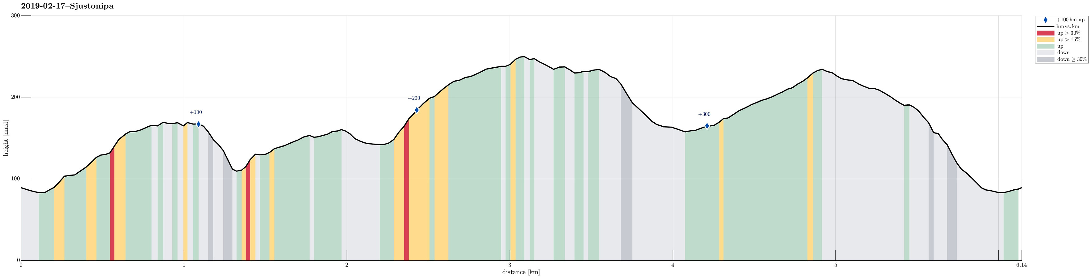
Sjurstonipa
- Dato:
- 17.02.2019
- Turtype:
- Fjelltur
- Turlengde:
- 2:00t
- Distanse:
- 6,1km
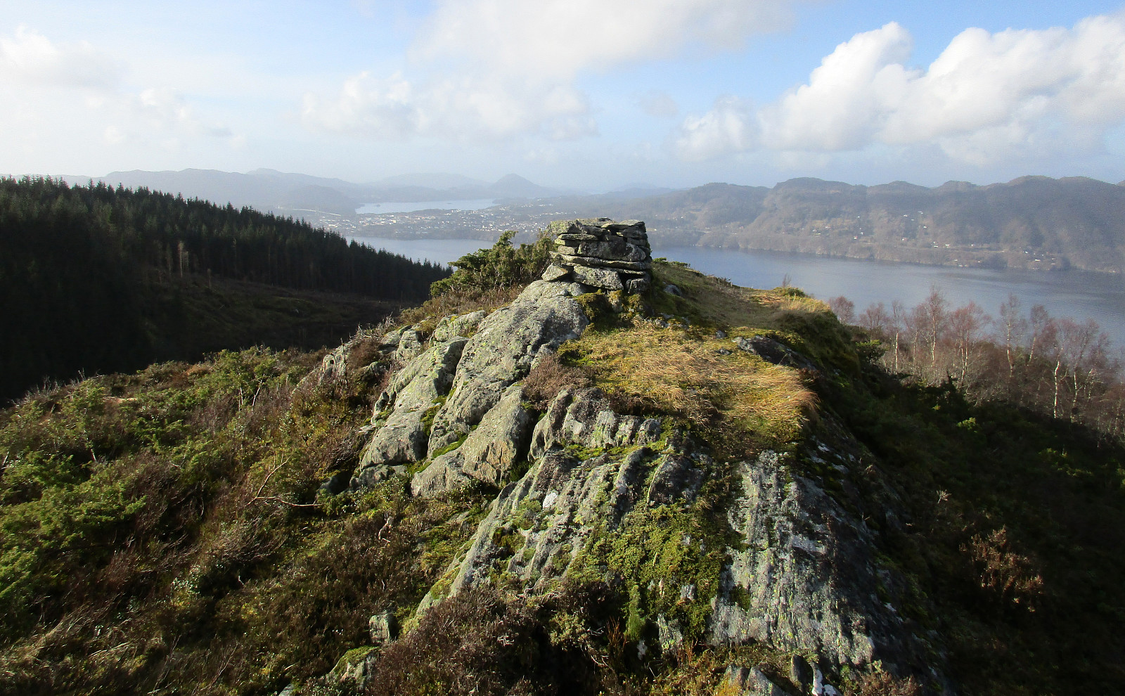
 We took the car from Bergen via Åsane to Gaupås and parked right at Arna stadion. Our first goal was to visit Osen (via Gamsevegen) and to check whether one indeed has a nice view from up there -- and, yes, the view, for example across Gaupåsvatnet, is quite nice! :-) From there, we wanted to connect to Sjurstonipa. But instead of taking the nice path back, which we used to get up to Osen, we descended along a stone wall that runs towards the east from Osen. At the lower end of this descent (near Kvernaskaret), the terrain is quite a bit steep and choosing ones steps carefully was advised (no problem, though, to get down to the saddle). On the other side, we then ascended to the Lavvo place near the upper houses of Ytre Arna. Instead of entering Ytre Arna, we continued across the "top", >>>
Førdesveten from Stranda
- Dato:
- 03.02.2019
- Turtype:
- Fjelltur
- Turlengde:
- 2:45t
- Distanse:
- 7,1km
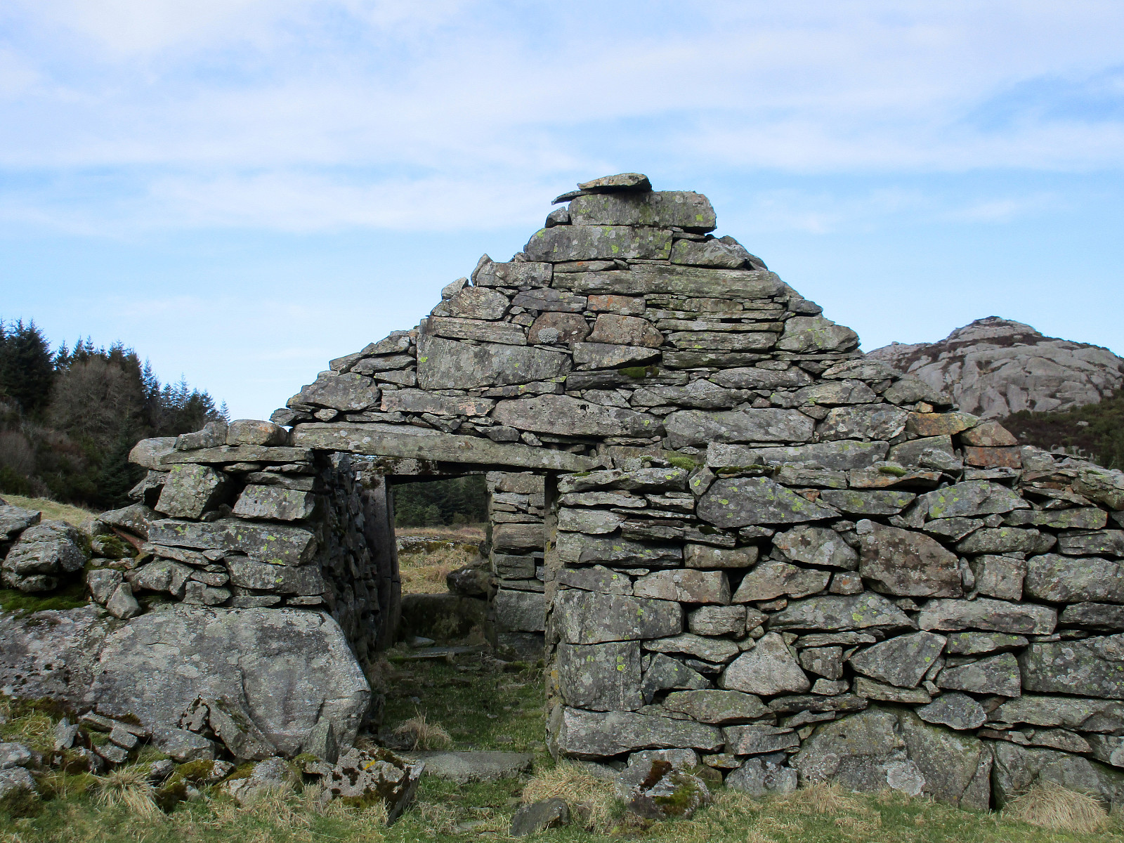
 We took road 555 towards Sotra and then further south to Sund. At the Stranda school we parked, starting our hike from there. We first followed a well-visible path over Lamhusfjellet in order to get into Kleppadalen. Also there, the path was easy to follow and we continued along it into the direction of Førdesveten. From Kleppadalen, we then ascended in northeastern direction towards a saddle, where another path comes down from Ramnaberget in the southeast. Instead of immediately continuing towards Førdesveten, we decided to quickly ascend Storevarden (in the northwest of the saddle). There were no steps to see in the snow, but proceeding to the top was nonetheless quite OK. At Storevarden, one can appreciate an impressive stone wall that probably was built to confine sheep towards >>>
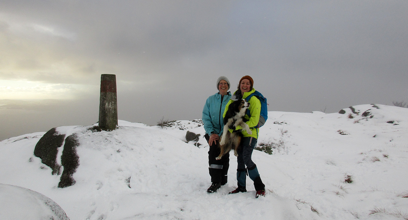
Snow-covered Liatårnet from Li
- Dato:
- 27.01.2019
- Turtype:
- Fjelltur
- Turlengde:
- 2:15t
- Distanse:
- 4,8km
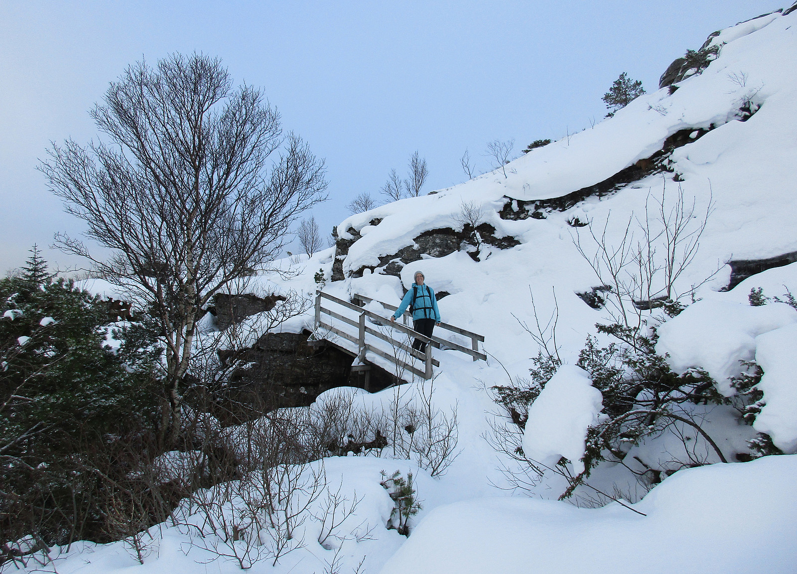
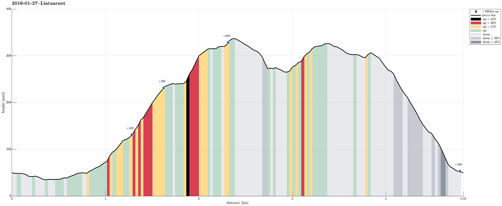 Considering the snow-covered landscape outside and comparably good weather, it was not too difficult to decide for a nice Sunday hike. We took our car towards the west (Sotra) and there to Li (on the east-side of Liatårnet). Near Haugane, we parked and continued along Liaskjervegen walking until we came to Hola, where we found Hølo (a short road up to the west from F206). Pretty much at the top end of this short road, we then found the path to Liatårnet (and were positively surprised that it was easy to find!). Since someone had gone there already, it was even easy to step up the snow-covered path. Furthermore, we got the impression that rather recently a substantial effort must have been put into this path (with a few signs here and there, a proper stone bridge across a small stream, >>>
Olsokfjellet, Damgårdsfjellet, and Gravdalsfjellet
- Dato:
- 19.01.2019
- Turtype:
- Fjelltur
- Turlengde:
- 2:00t
- Distanse:
- 6,1km
 We started near Betanien hospital in upper Fyllingsdalen and walked upwards into Nordnæsdalen. A little north of the sports plain at Nordnæsdalen, we found the path to the right (east), which leads up to Olsokfjellet. Half way up, when leaving the trees behind, we enjoyed a few nice views towards the south and over Fyllingsdalen. From the top of Olsokfjellet, we connected to Damsgårdsfjellet. After crossing Damsgårdsfjellet southeast--northwest, we descended into Skaret (icy!) before continuing into the direction of Gravdalsfjellet from there (mostly westwards, first). Finding all the paths in the snow without any difficulties, we quickly connected to Gravdalsfjellet. At the top of Gravdalsfjellet, we again enjoyed some nice views! :-) Descending in southern direction from there, >>>
Brakafjellet etc.
- Dato:
- 13.01.2019
- Turtype:
- Fjelltur
- Turlengde:
- 4:00t
- Distanse:
- 10,6km
 We expected a few hours of nice weather and thus left home before lunch to get started.
Also this time , our plan was to hike some not so often visited tops in Sund kommune. We took road 555 to Sotra and then further to the south until we came to a small place called Vorland. There, we parked and started our hike along Gjerdevegen (in eastern direction). Soon behind the last house at Gjerdevegen we crossed over some wet terrain (still in eastern direction), in order to connect to a simple path that then continues in northeastern direction (towards Kleiva). At Kleiva, we departed from the trail and continued in northeaster direction through a little valley. We continued through a trough into the direction of Djupeskarvatnet (all this without a path). At Djupeskarvatnet, we connected to another simple >>>
We expected a few hours of nice weather and thus left home before lunch to get started.
Also this time , our plan was to hike some not so often visited tops in Sund kommune. We took road 555 to Sotra and then further to the south until we came to a small place called Vorland. There, we parked and started our hike along Gjerdevegen (in eastern direction). Soon behind the last house at Gjerdevegen we crossed over some wet terrain (still in eastern direction), in order to connect to a simple path that then continues in northeastern direction (towards Kleiva). At Kleiva, we departed from the trail and continued in northeaster direction through a little valley. We continued through a trough into the direction of Djupeskarvatnet (all this without a path). At Djupeskarvatnet, we connected to another simple >>>
Wet Løvstakken
- Dato:
- 06.01.2019
- Turtype:
- Fjelltur
- Turlengde:
- 1:45t
- Distanse:
- 5,2km
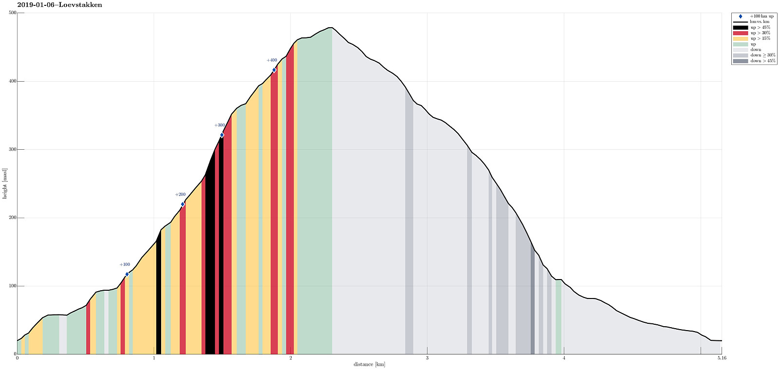 Even though the clouds were hanging really low and even though it was as wet outside as it looked from inside (very!), we still decided to get some fresh air. We chose Løvstakken, but wished to hike it from Krambua and long a trail that we wished to explore. We parked near the BoA sports shop and after a few "wild meters", we were ready to walk up Grønnestølen (along Grønnestølensveien first, then further up parallel to a little stream that comes down in the south of Grønnestølen. Ascending on the right (eastern) side of this stream, we continued further up along a nice (and quite steep) path (though Dalen). At about 250mosl, we briefly lost our path, but managed to reconnect to it soon after. From there, then, it was pretty straight-forward to further ascend to Løvstakken >>>
Tveitafjellet
- Dato:
- 01.01.2019
- Turtype:
- Fjelltur
- Turlengde:
- 1:30t
- Distanse:
- 4,1km
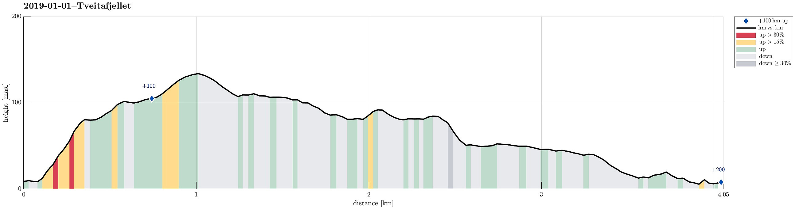 In order to get some fresh air, we disregarded the unfavorable weather conditions (rather strong storm, intermixed with some precipitation) and headed towards Sotra. The bridge (Sotrabrua) was guarded on both sides, because of the strong winds, but we could still cross over. On Sotra, we continued along road #555 towards Fjell and from there further south, coming by Dala and Hammarsland. At Tveita, we then started to look out for a spot, where we could park, but continued to Eide just a bit further south to actually find a suitable place along the road. Sine we had planned to go up Tveitafjellet first, we first walked a bit back along the road (in northern direction) until we found a good spot to enter Eidesdalen, just southwest of Tveitafjellet. Only a few steps into this valley, however, >>>
Knappen
- Dato:
- 30.12.2018
- Turtype:
- Fjelltur
- Turlengde:
- 1:00t
- Distanse:
- 4,1km
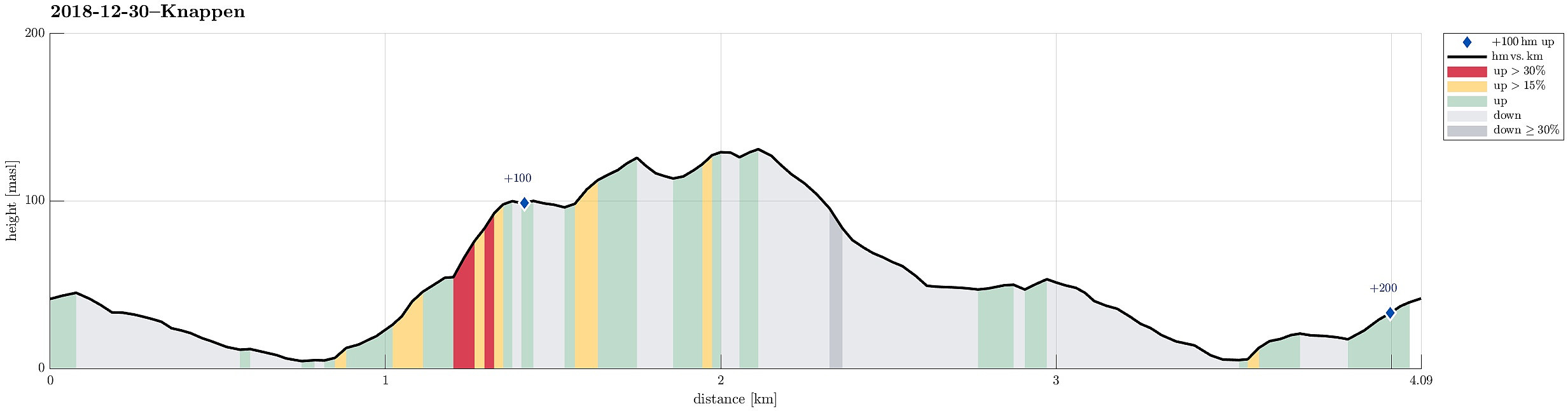 We only had a bit of time to get some fresh air and thus decided to do Knappen, once again. :-) We started from Varden, descended to Bjørgeveien first, before then using Sandeidbrotet to connect to a path that would lead us further up and towards Knappen. Once up on the heights (still in the very north of Knappen), we this time followed a minor (and wet) path more towards the northeastern side of the "Knappen-plateau" (than the more usual path on the western side). Halfway along this path, however, we decided that we would still cross over to the "top" of Eldtona, before continuing further to Knappen. Once on Knappen, we this time chose the path leading (more or less) directly down to Knappatjørna (in eastern direction). Before actually getting all the way down, however, >>>
