Arkiv - dato
Arkiv - aktivitet
-
Annen tur (1)
- Kajakkpadling (1)
-
Annen vintertur (4)
- Trugetur (4)
- Fottur (740)
-
Skitur (4)
- Fjellskitur (4)
-
Sykkeltur (137)
- Blandet sykling (51)
- Gatesykling (9)
Arkiv - Etter geografi
"Peakbookvenner"


Lister jeg samler etter
-
Bergen ≥ 50m pf. og ≥ 100 m.o.h.
(87/89)
 97%
97% -
Most dominating tops of the Bergen peninsula
(68/75)
90%
-
Utvalgte topper og turmål i Bergen
(316/350)
90%
-
Alle topper i Bergen
(357/398)
89%
-
Opptur Bergen
(100/113)
88%
-
De syv fjell rundt Bergen
(6/7)
85%
-
Sund ≥ 50m pf.
(14/18)
77%
-
Os ≥ 50m pf.
(25/34)
73%
-
Søyler (fastmerker) i Bergen
(68/100)
68%
-
Fjell ≥ 50m pf.
(21/32)
65%

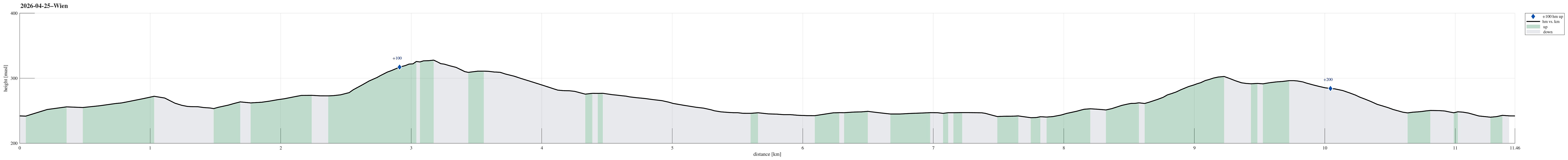
Through Wien to Donaukanal
- Dato:
- 26.04.2026
- Turtype:
- Gatesykling
- Turlengde:
- 1:00t
- Distanse:
- 13,2km
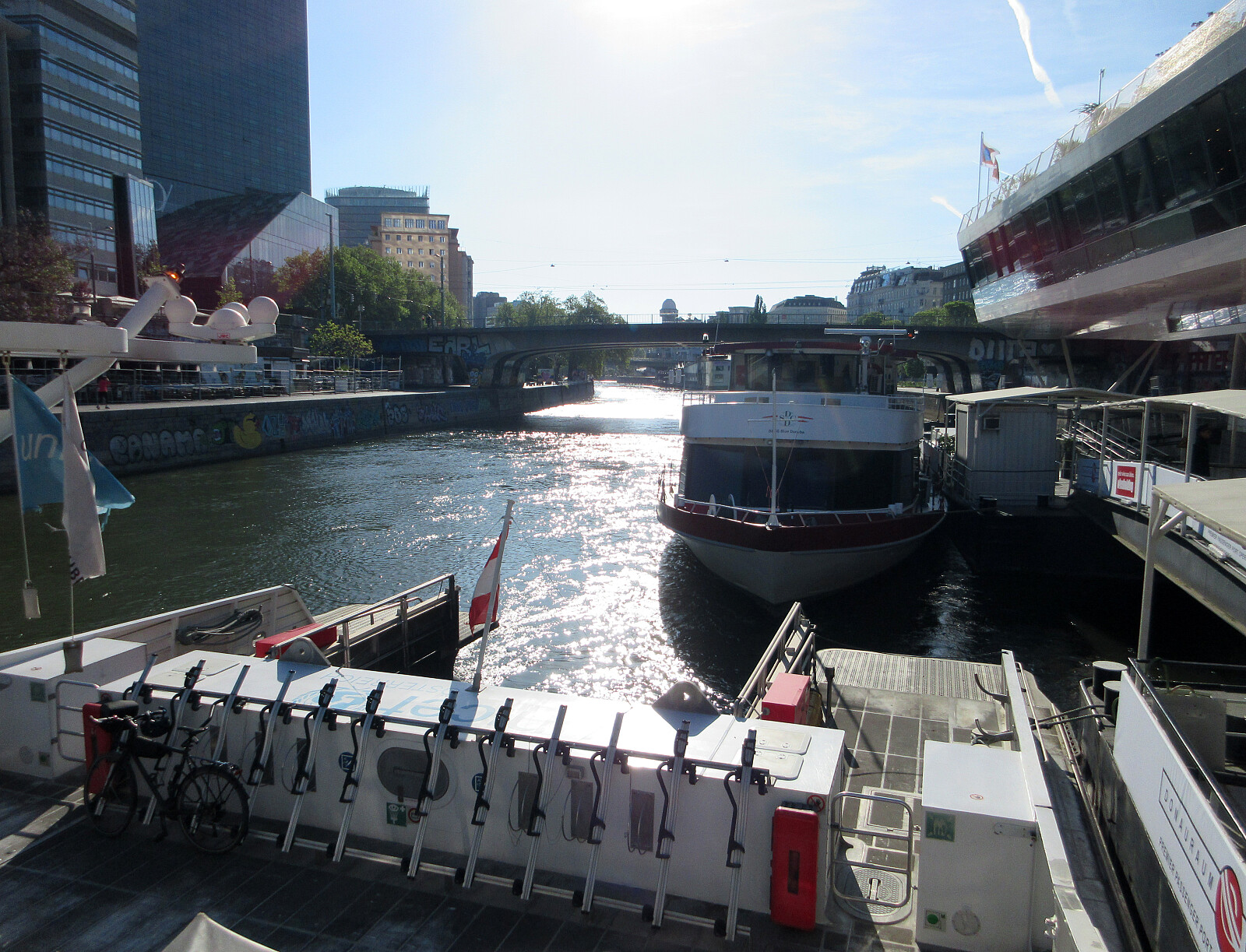 Main goal for this day was to get from Vienna to Smolenice (partly by boat, partly by bike). To first get to the boat (TwinCityLiner) in Vienna, I needed to bridge some 13km by bike in the early morning, first. Nothing special about the bike-route, though, to report.
Selected photos are available as Google photo album .
The TwinCityLiner is an interesting alternative option to get from Vienna to Bratislava (or the other way around).
Main goal for this day was to get from Vienna to Smolenice (partly by boat, partly by bike). To first get to the boat (TwinCityLiner) in Vienna, I needed to bridge some 13km by bike in the early morning, first. Nothing special about the bike-route, though, to report.
Selected photos are available as Google photo album .
The TwinCityLiner is an interesting alternative option to get from Vienna to Bratislava (or the other way around).
Wotruba Church and Hörndlwald
- Dato:
- 25.04.2026
- Turtype:
- Blandet sykling
- Turlengde:
- 2:00t
- Distanse:
- 11,5km
 Just a short bike-ride to visit the Wotruba Church in the southwest of Vienna, followed by a nice (short) walk through Hörndlwald.
Selected photos are available as Google photo album .
There's a useful page about the Wotruba Church on Wikipedia .
Just a short bike-ride to visit the Wotruba Church in the southwest of Vienna, followed by a nice (short) walk through Hörndlwald.
Selected photos are available as Google photo album .
There's a useful page about the Wotruba Church on Wikipedia .
To Åsane, and back
- Dato:
- 19.04.2026
- Turtype:
- Gatesykling
- Turlengde:
- 3:00t
- Distanse:
- 55,1km
 The main plan for the day was to visit the textile factor museum in Salhus. To get there, we had planned to take a historic bus from Åsane terminal. To get to Åsane, we used our bikes. Nothing special to report about the bike-trip, though (we biked the same route there and back, using the main bike route around Eidsvågsneset).
See also the related FB-page Hiking around Bergen, Norway .
The main plan for the day was to visit the textile factor museum in Salhus. To get there, we had planned to take a historic bus from Åsane terminal. To get to Åsane, we used our bikes. Nothing special to report about the bike-trip, though (we biked the same route there and back, using the main bike route around Eidsvågsneset).
See also the related FB-page Hiking around Bergen, Norway .
Short round around Varden
- Dato:
- 18.04.2026
- Turtype:
- Spasertur
- Turlengde:
- 0:45t
- Distanse:
- 2,1km
 Just an evening walk around Varden, including a short visit to Gjeddevatnet.
See also the related FB-page Hiking around Bergen, Norway .
Just an evening walk around Varden, including a short visit to Gjeddevatnet.
See also the related FB-page Hiking around Bergen, Norway .
To Arboretet in Milde, and back
- Dato:
- 12.04.2026
- Turtype:
- Blandet sykling
- Turlengde:
- 2:00t
- Distanse:
- 29,1km
 Just a nice bike-ride to/from Arboretet in Milde. On our way back, we decided to take a slightly different route, following Grimseidvegen, towards the northeast, before finding a connection towards Skage through Skageskogen passing by Kolhushaugen. From Skage, we then continued along Håvardstunvatnet and Skranevatnet. Via Søvik, we eventually made it back onto usual tracks.
See also the related FB-page Hiking around Bergen, Norway .
Just a nice bike-ride to/from Arboretet in Milde. On our way back, we decided to take a slightly different route, following Grimseidvegen, towards the northeast, before finding a connection towards Skage through Skageskogen passing by Kolhushaugen. From Skage, we then continued along Håvardstunvatnet and Skranevatnet. Via Søvik, we eventually made it back onto usual tracks.
See also the related FB-page Hiking around Bergen, Norway .
Tysnessåta from Myrdal
- Dato:
- 11.04.2026
- Turtype:
- Fottur
- Turlengde:
- 3:45t
- Distanse:
- 6,9km
 The idea was to make a nice hike on a nice day, which would (1) bring us up to enjoy some nice views and (2) avoid significant amounts of snow, if possible (well, well). We took the ferry from Halhjem to Våge and then drove around and up to Myrdal (already at about 195masl). After parking near Storåkerhølen, a bit north of Myrdal, we started our hike first on a tractor road across Myrdal, before getting into the real hike from the "second" parking place south of Myrdal. From there, one can now (since 2024) find a "Sherpasti" with numerous impressive rock steps that are laid down for large stretches of the ascent along Steinelva. This way, one can "simply" step up these stone steps and reach the heights of Tysnessåta quickly (one still needs to make about >>>
Exploring Skiparvika and Skjoldabukta
- Dato:
- 06.04.2026
- Turtype:
- Blandet sykling
- Turlengde:
- 4:00t
- Distanse:
- 32,6km
 Just a nice bike trip around Nordåsvatnet (with a bit of exploration near Skjoldabukta). In the southwest of Nordåsvatnet, we followed a "side-line", which brought us to Skranevatnet and Håvardstunvatnet, before passing also by Skeievatnet (then in the south of Nordåsvatnet). After thereafter cycling around Apeltunvatnet, we arrived at Skjold, where we left the bikes behind for a short walk to Skiparvika and Skjoldabukta. On our way back, we traversed Nybøvegen before reconnecting with more usual paths. Just near Hopsbukta, we also included a short detour along Nordahl Griegs vei, before then following the standard route back.
See also the related FB-page Hiking around Bergen, Norway .
Just a nice bike trip around Nordåsvatnet (with a bit of exploration near Skjoldabukta). In the southwest of Nordåsvatnet, we followed a "side-line", which brought us to Skranevatnet and Håvardstunvatnet, before passing also by Skeievatnet (then in the south of Nordåsvatnet). After thereafter cycling around Apeltunvatnet, we arrived at Skjold, where we left the bikes behind for a short walk to Skiparvika and Skjoldabukta. On our way back, we traversed Nybøvegen before reconnecting with more usual paths. Just near Hopsbukta, we also included a short detour along Nordahl Griegs vei, before then following the standard route back.
See also the related FB-page Hiking around Bergen, Norway .
To Bergen and back
- Dato:
- 04.04.2026
- Turtype:
- Blandet sykling
- Turlengde:
- 1:30t
- Distanse:
- 25,0km
 Just a nice evening bike-trip to Bergen (and back).
See also the related FB-page Hiking around Bergen, Norway .
Just a nice evening bike-trip to Bergen (and back).
See also the related FB-page Hiking around Bergen, Norway .
Round around Fyllingsdalen
- Dato:
- 03.04.2026
- Turtype:
- Blandet sykling
- Turlengde:
- 4:00t
- Distanse:
- 27,5km
 With a prediction of rain in the early afternoon, we decided to just cycle a little (towards Bergen and back), instead of aiming for a mountain top. First, we headed northwards along Bjørgeveien. Instead of cycling directly to Bjørndalen, however, we decided to make a simple detour around Bjørndalspollen, taking advantage of the little bridge at Hetlevikstraumen. At Loddefjord, we turned right and continued towards Laksevåg on the southeasern side of Lyderhorn (along Liavatnet). In the north of Holefjellet, we then parked our bikes for a few minutes to walk up to Noven and take a look at the historic relics from WWII there. Especially in times, when war seems to become "normal" again, it's moving particularly to be reminded of the major catastrophy that unfolded when a four-digit >>>
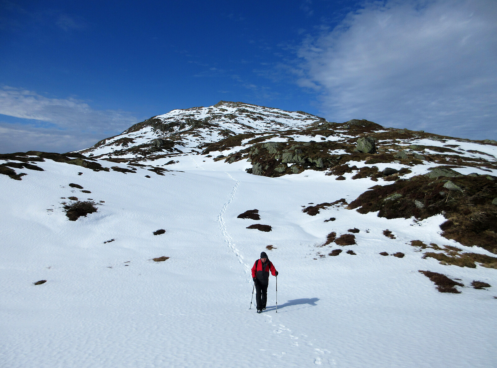
Høgstefjellet and Tellevikafjellet
- Dato:
- 02.04.2026
- Turtype:
- Fottur
- Turlengde:
- 4:00t
- Distanse:
- 9,4km
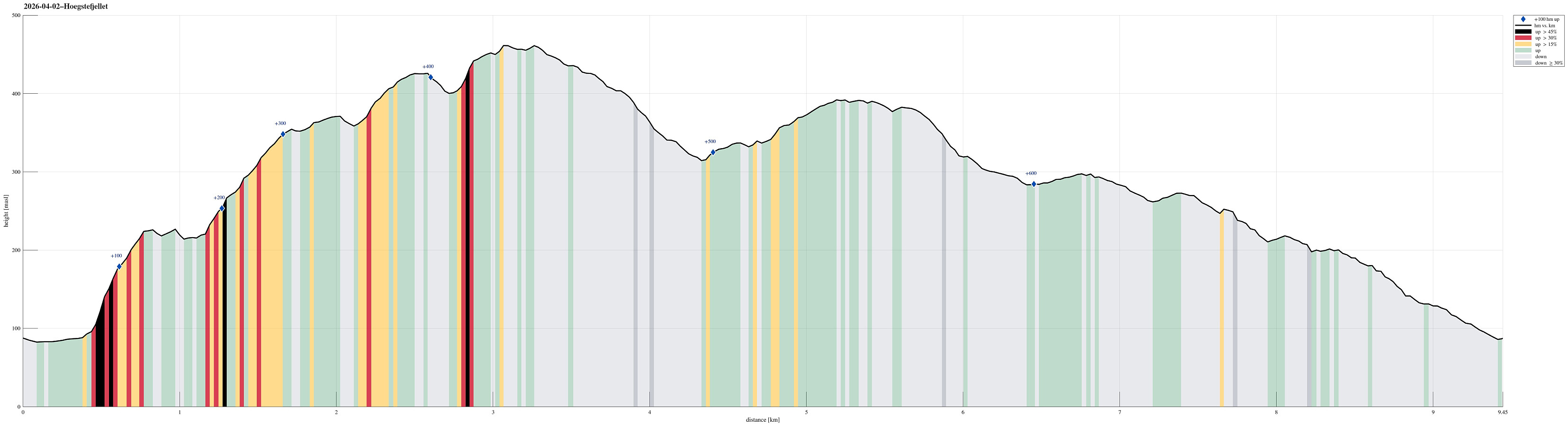 We expected a nice day and wished to make a nice hike without getting into too deep (wet) snow. The round around Baugtveitstemma, including Høgstefjellet and Tellevikafjellet, seemed just right. We found a place to leave the car behind near Salhusvegen, where one turns to towards Hitland and Baugtveit (further up the road). The original plan was to head eastwards, first, to get to a trail, which leads up to Huseberget from Salhusvegen. One from Hitland, however, was determined to avoid us going there (because of some sheep on the eastern side of Hitland). This required making up a plan B, which then basically was to ascend to Huseberget from the west (instead of from the south). Without having prepared this carefully at home, first, however, and knowing (and seeing) how steep Huseberget >>>
