Arkiv - dato
Arkiv - aktivitet
-
Annen tur (1)
- Kajakkpadling (1)
-
Annen vintertur (4)
- Trugetur (4)
- Fottur (740)
-
Skitur (4)
- Fjellskitur (4)
-
Sykkeltur (137)
- Blandet sykling (51)
- Gatesykling (9)
Arkiv - Etter geografi
"Peakbookvenner"


Lister jeg samler etter
-
Bergen ≥ 50m pf. og ≥ 100 m.o.h.
(87/89)
 97%
97% -
Most dominating tops of the Bergen peninsula
(68/75)
90%
-
Utvalgte topper og turmål i Bergen
(316/350)
90%
-
Alle topper i Bergen
(357/398)
89%
-
Opptur Bergen
(100/113)
88%
-
De syv fjell rundt Bergen
(6/7)
85%
-
Sund ≥ 50m pf.
(14/18)
77%
-
Os ≥ 50m pf.
(25/34)
73%
-
Søyler (fastmerker) i Bergen
(68/100)
68%
-
Fjell ≥ 50m pf.
(21/32)
65%

Jubiläumswarte and Mahnmal für die Opfer vom Spiegelgrund
- Dato:
- 25.10.2025
- Turtype:
- Blandet sykling
- Turlengde:
- 3:00t
- Distanse:
- 32,8km
 I used my bike to visit the northwest of Vienna, biking first there, before eventually making a round to/from Jubiläumswarte on foot. One the way back, I then passed by the Mahnmal für die Opfer vom Spiegelgrund (memorial commemorating the victims at Spiegelgrund) at night, seeing the 772 steles lit for the first time. Clearly, it is very moving to visit this memorial at night!
Selected photos are available as Google photo album .
See also the related FB-page Hiking around Bergen, Norway .
Several other sites, including one at geschichtewiki.wien.gv.at and the one at gedenkstaettesteinhof.at remind of the grim history of Steinhof.
I used my bike to visit the northwest of Vienna, biking first there, before eventually making a round to/from Jubiläumswarte on foot. One the way back, I then passed by the Mahnmal für die Opfer vom Spiegelgrund (memorial commemorating the victims at Spiegelgrund) at night, seeing the 772 steles lit for the first time. Clearly, it is very moving to visit this memorial at night!
Selected photos are available as Google photo album .
See also the related FB-page Hiking around Bergen, Norway .
Several other sites, including one at geschichtewiki.wien.gv.at and the one at gedenkstaettesteinhof.at remind of the grim history of Steinhof.
Back to Austria via Sella Nevea (from Moggio)
- Dato:
- 22.10.2025
- Turtype:
- Sykkeltur
- Turlengde:
- 7:30t
- Distanse:
- 75,3km
 The plan for the fourth (and last) day of our four-days bike ride through the Julian Alps was to bike back to Austria from Moggio. Again, we started relatively early in Moggio to have enough time for the roughly 75km back (including the Selle Nevea mountain pass). This time, we were updated enough to understand that parallel to the main road (SS13) through the valley of Fiume Fella one can find the Alpe-Adri cycling path, which is using an abandoned train line! Using this cycling path, we nicely made it to Chiusaforte without any road stress! :-) Also, we could enjoy some nice sights along the way, including Ponte Peraria and several tall waterfalls. In Chiusaforte, we then said "Good bye!" to the cycling path and entered Val Raccolana towards Sella Nevea further in the east. While it was not raining, the clouds were >>>
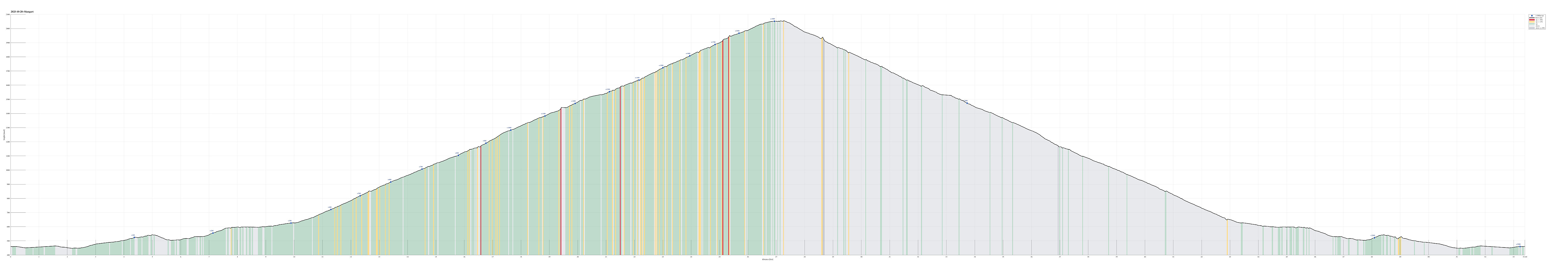
Through Val Resia to Moggio (from Bovec)
- Dato:
- 21.10.2025
- Turtype:
- Sykkeltur
- Turlengde:
- 6:00t
- Distanse:
- 46,0km
 The plan for the third day of our four-days bike ride through the Julian Alps was to bike from Bovec to Moggio di Sotto via Val Resia. The weather forecast predicted rain throughout the day and it was right: it rained continuously. We first biked from Bovec down to Žaga, where we turned towards the west (and upwards again). Following the very nice mountain road towards the border between Slovenia and Italy, we enjoyed the fact that hardly any cars were on the same street. Instead, we got to see several fire salamanders that likely enjoyed the rain! :-) Before actually crossing over the border, we had to get over a small prelude saddle (where previously the Slovenian border control was?). From there, it was then a short stretch down to (and over) the Učja river. Once on the other, northern side, we eventually crossed the border >>>
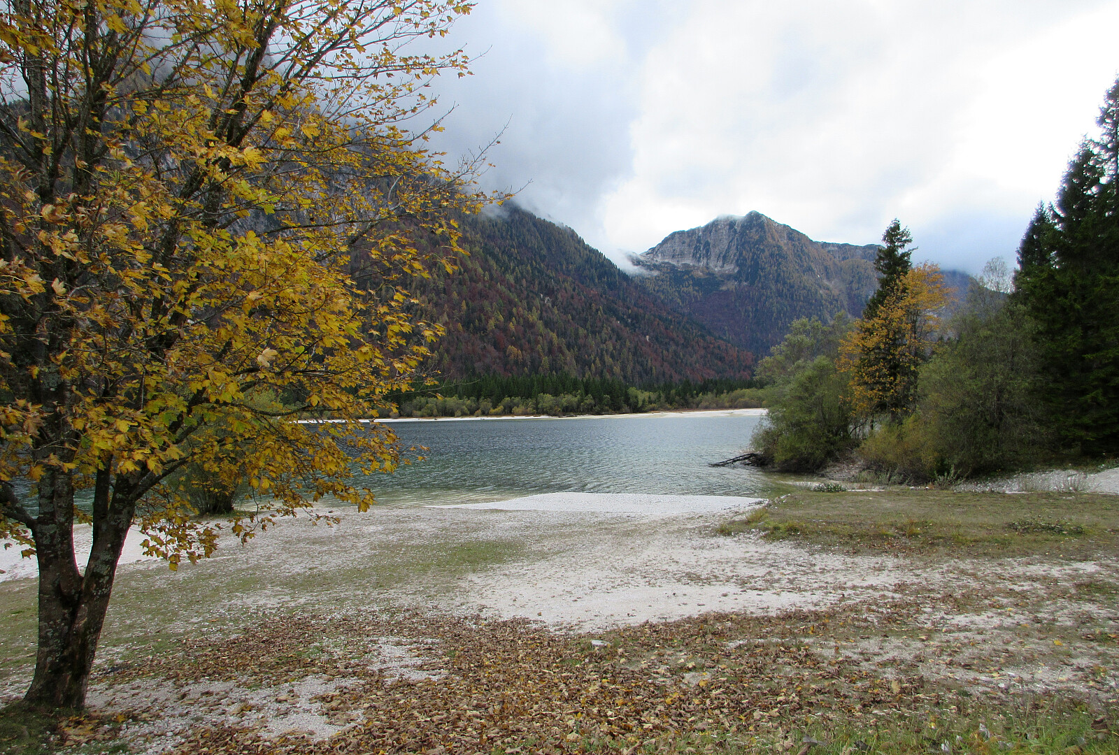
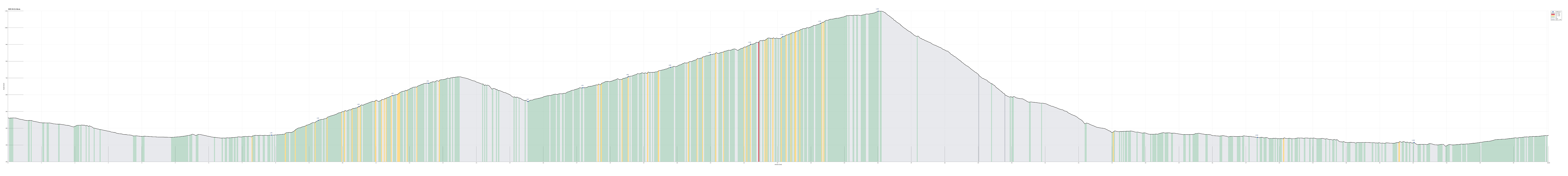
Up to the Mangart saddle, from/to Bovec
- Dato:
- 20.10.2025
- Turtype:
- Sykkeltur
- Turlengde:
- 7:00t
- Distanse:
- 53,4km
 The idea for the second day of our four-days bike ride through the Julian Alps was to ascend to Mangart from Bovec and then return back to Bovec. The weather report was not 100% promising, predicting rain for the afternoon. It was very clear to us that attempting a very steep mountain road in wet and cold conditions would not be wise at all. To thus account for the weather uncertainy, we also had made a backup plan: ride up to Predel, instead, and then back to Bovec from there. We started from Bovec at around 8h30 and quickly hit the road northwards. Soon we passed the junction, where one could follow the road through the Soča valley, eventually up to Vršič, which we had come down the day before. This day, we instead continued further upwards into the Koritnica valley. A bit more than 4km into our ride, we then inspected Fort >>>
From Erlendorf to Bovec via Wurzenpaß and Vršič
- Dato:
- 19.10.2025
- Turtype:
- Sykkeltur
- Turlengde:
- 7:00t
- Distanse:
- 60,5km
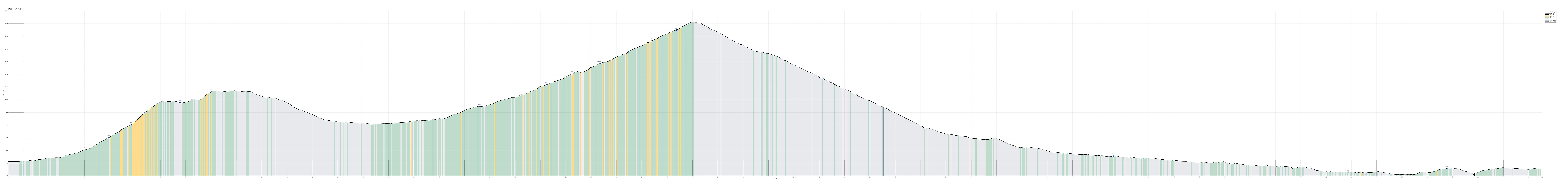 On the first (first real) day of our four-days bike ride through the Julian Alps , we aimed at biking from Erlendorf to Bovec over Wurzenpaß and Vršič. Starting at about 8h30 in the morning in Erlendorf, we headed for the street that leads up to Wurzenpaß immediately. After only about half a kilometer, it became clear that cycling up to Wurzenpaß would be harder than originally anticipated (the rather naive, initial idea was that Wurzenpaß would serve as a quick and not-too-hard warm-up exercise before going for the real pass over Vršič). Even though it was "only" about 500 height meters up from Erlendorf, the challenge was in the slopes, which topped out at about 18% (very steep for cycling indeed)! On Wurzenpaß, we stopped to look at an old tank right next to the road, which reminds visitors of WWII and the time >>>
Erlendorf-Arnoldstein and back
- Dato:
- 18.10.2025
- Turtype:
- Sykkeltur
- Turlengde:
- 2:00t
- Distanse:
- 13,8km
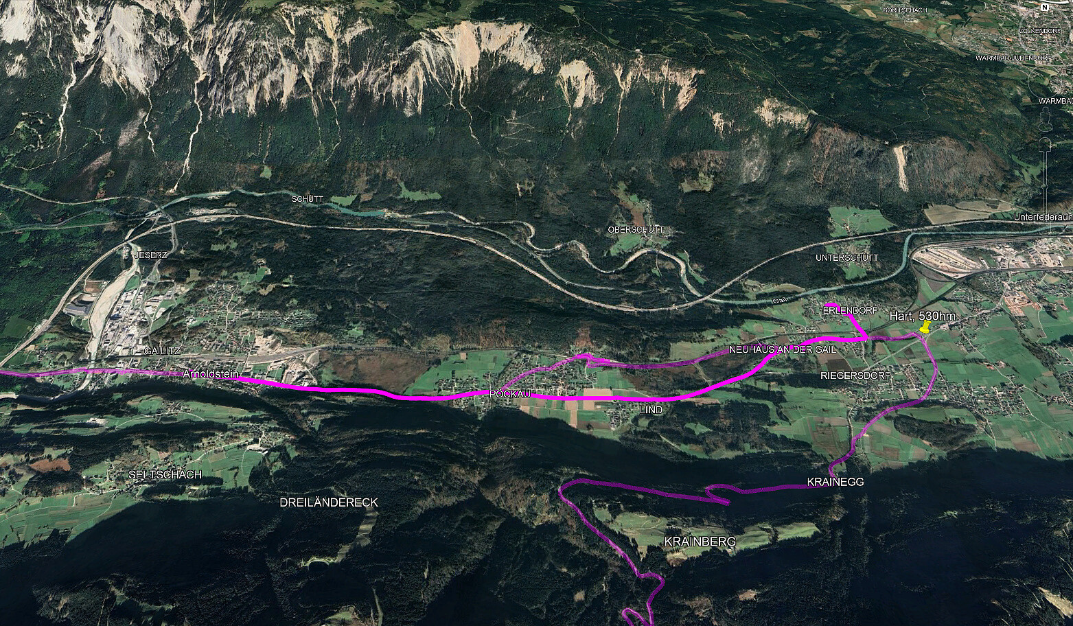 On the eve of our four-days bike ride through the Julian Alps , we arrived rather late in Erlendorf. To fill up some energy, not at the least for the coming day, we cycled over to Arnoldstein for some nice dinner. This short evening ride also served well as a test of the rental bike, which one of us had to use for these days.
See also the related FB-page Hiking around Bergen, Norway .
See also another page about this four-(five-)days bike trip .
On the eve of our four-days bike ride through the Julian Alps , we arrived rather late in Erlendorf. To fill up some energy, not at the least for the coming day, we cycled over to Arnoldstein for some nice dinner. This short evening ride also served well as a test of the rental bike, which one of us had to use for these days.
See also the related FB-page Hiking around Bergen, Norway .
See also another page about this four-(five-)days bike trip .
Liatårnet from Fjellavegen via Fjellasåta
- Dato:
- 12.10.2025
- Turtype:
- Fottur
- Turlengde:
- 4:00t
- Distanse:
- 7,4km
 We parked south of Fjell along Søre Fjellavegen and started our hike by aiming at Fjellasåta via Rindane. Basically at the saddle, where Søre Fjellavegen starts to descend again towards the south, we found a very basic trail (or something like that), which brought us well up and onto Rindane (towards the east). Even though this trail (or "trail") was not always immediately obvious, we still made it quickly and easily to Fjellasåta (Kannikahaugen). From there, and instead of following the north-south oriented trail across Fjellasåta, we proceeded further eastwards (towards the southern end of Gyravatnet). When down at Festningsvegen, we did not have to search long before we found a little opening in the thick valley forest. This opening connected to a simple "trail" >>>
Lyderhorn from Kjøkkelvikveien
- Dato:
- 05.10.2025
- Turtype:
- Fottur
- Turlengde:
- 2:00t
- Distanse:
- 4,7km
 We parked close to the Kjøkkelvikveien-Nedbergeveien junction and first walked a bit along Kjøkkelvikveien to find a good place for starting our ascent towards Stemmebakkane and Høgenuten. Opposite to Fæsterveien, we then found a narrow access road, leading up to the house with number 105. After the second hairpin curve up the rather steep mountain side, we then followed a simple trail into the forest (and further upwards). Even though there's no trail to be seen on Norgeskart for this part, one still can find simple hiking trails "all the way up" to Stemmebakkane and Høgenuten. From up there, one also then can enjoy some nice views. A bit south of Høgenuten, one then joins the main trail to Lyderhorn. After making it "all the way up" to Lyderhorn (not so much >>>
City walk through Delft
- Dato:
- 03.10.2025
- Turtype:
- Spasertur
- Turlengde:
- 2:30t
- Distanse:
- 9,2km
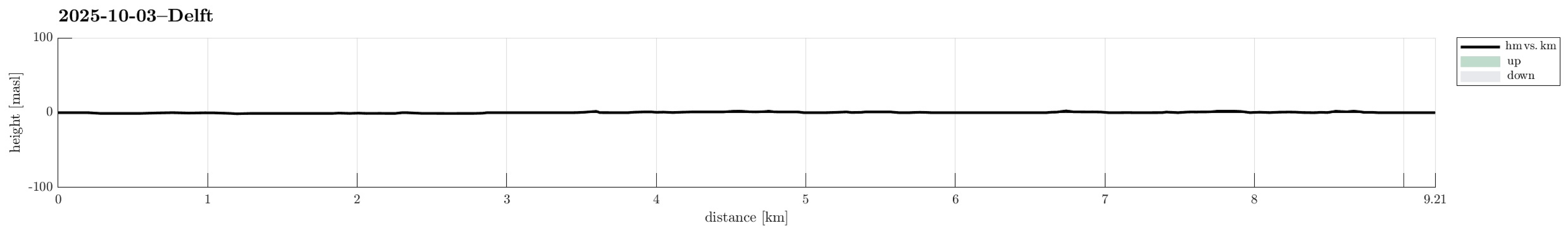 Having a bit of extra time on my hand, I decided to explore Delft a little (despite the clearly rainy weather). This brought me both to the campus of TU Delft, as well as into the center of Deft (twice), including Oude Delft, Markt, Beestenmarkt, etc. :-)
Selected photos are available as Google photo album .
See also the related FB-page Hiking around Bergen, Norway .
Having a bit of extra time on my hand, I decided to explore Delft a little (despite the clearly rainy weather). This brought me both to the campus of TU Delft, as well as into the center of Deft (twice), including Oude Delft, Markt, Beestenmarkt, etc. :-)
Selected photos are available as Google photo album .
See also the related FB-page Hiking around Bergen, Norway .
