Arkiv - dato
Arkiv - aktivitet
-
Annen tur (1)
- Kajakkpadling (1)
-
Annen vintertur (4)
- Trugetur (4)
- Fottur (740)
-
Skitur (4)
- Fjellskitur (4)
-
Sykkeltur (137)
- Blandet sykling (51)
- Gatesykling (9)
Arkiv - Etter geografi
"Peakbookvenner"


Lister jeg samler etter
-
Bergen ≥ 50m pf. og ≥ 100 m.o.h.
(87/89)
 97%
97% -
Most dominating tops of the Bergen peninsula
(68/75)
90%
-
Utvalgte topper og turmål i Bergen
(316/350)
90%
-
Alle topper i Bergen
(357/398)
89%
-
Opptur Bergen
(100/113)
88%
-
De syv fjell rundt Bergen
(6/7)
85%
-
Sund ≥ 50m pf.
(14/18)
77%
-
Os ≥ 50m pf.
(25/34)
73%
-
Søyler (fastmerker) i Bergen
(68/100)
68%
-
Fjell ≥ 50m pf.
(21/32)
65%

Knappen
- Dato:
- 29.09.2024
- Turtype:
- Spasertur
- Turlengde:
- 0:45t
- Distanse:
- 4,7km
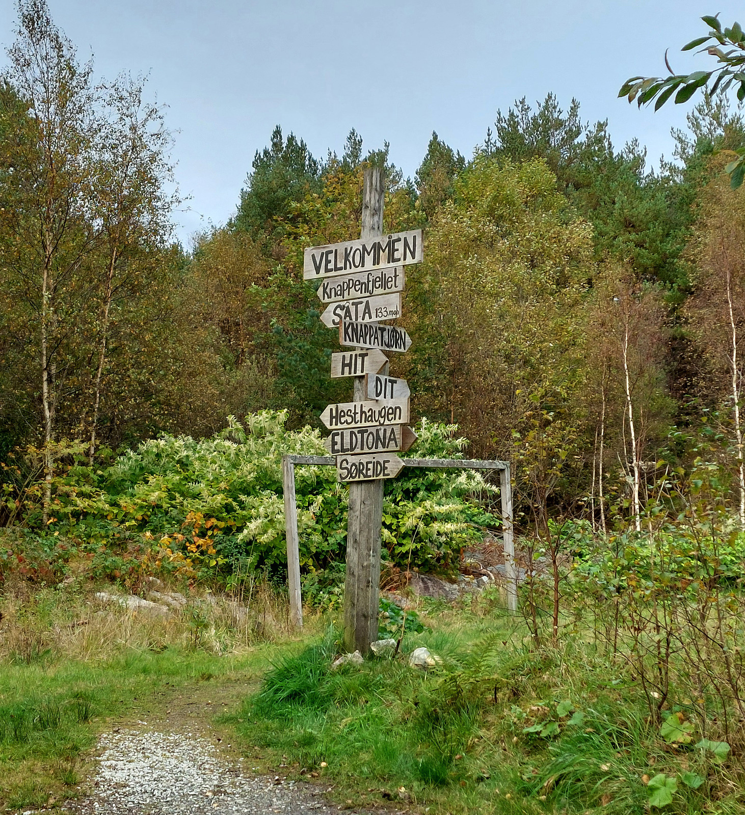 Instead of doing something larger and longer, we "ended up" making a short excursion to Knappen, only. Short, but nice! :-)
See also the related FB-page Hiking around Bergen, Norway .
Petter Bjørstad has a useful page about Knappen .
Web page UT.no from the Norwegian Trekking Association recommends another hike to Knappen .
Instead of doing something larger and longer, we "ended up" making a short excursion to Knappen, only. Short, but nice! :-)
See also the related FB-page Hiking around Bergen, Norway .
Petter Bjørstad has a useful page about Knappen .
Web page UT.no from the Norwegian Trekking Association recommends another hike to Knappen .
Nancy, Zinnerbach
- Dato:
- 21.09.2024
- Turtype:
- Spasertur
- Turlengde:
- 1:30t
- Distanse:
- 4,2km
 I wished to explore the area of Nancy, not far from Kraslice/Graslitz. I parked at the moderately large parking lot in Nancy and then walked -- first along the road, then up the forest road that extends in parallel to Zinnerbach. Once "up on the heights", or so, I turned around, also since I did not have more time, and walked back the same route.
Selected photos are available as Google photo album .
See also the related FB-page Hiking around Bergen, Norway .
I wished to explore the area of Nancy, not far from Kraslice/Graslitz. I parked at the moderately large parking lot in Nancy and then walked -- first along the road, then up the forest road that extends in parallel to Zinnerbach. Once "up on the heights", or so, I turned around, also since I did not have more time, and walked back the same route.
Selected photos are available as Google photo album .
See also the related FB-page Hiking around Bergen, Norway .
Bulandet by bike (and Høgkletten)
- Dato:
- 08.09.2024
- Turtype:
- Blandet sykling
- Turlengde:
- 5:00t
- Distanse:
- 31,5km
 We got onto our bikes on Værøyna and headed westwards into the direction of Bulandet along Nordsjøvegen. After crossing over several bridges, we made our first stop on Gjørøyna to take a look at "Ro" by artist Geir Hjetland. From there, we continued further southwestwards until we "hit" the end of the road at Halsøy. There, we stepped up to Slotteholmen to enjoy some views. We then biked over to Nikkjøyna and from there further to Hellersøyna, where we walked a little bit southwards to see the sculpture of Berte and Hansine. Then, we biked back to Værøyna (along the same road that we had taken to Bulandet, i.e., Nordsjøvegen). At Værøyna, we had a brief discussion and decided that only one of us would also include the short hike up to Høgkletten. I thus >>>
Instenova and Ytstenova on Alden
- Dato:
- 07.09.2024
- Turtype:
- Fottur
- Turlengde:
- 4:00t
- Distanse:
- 6,2km
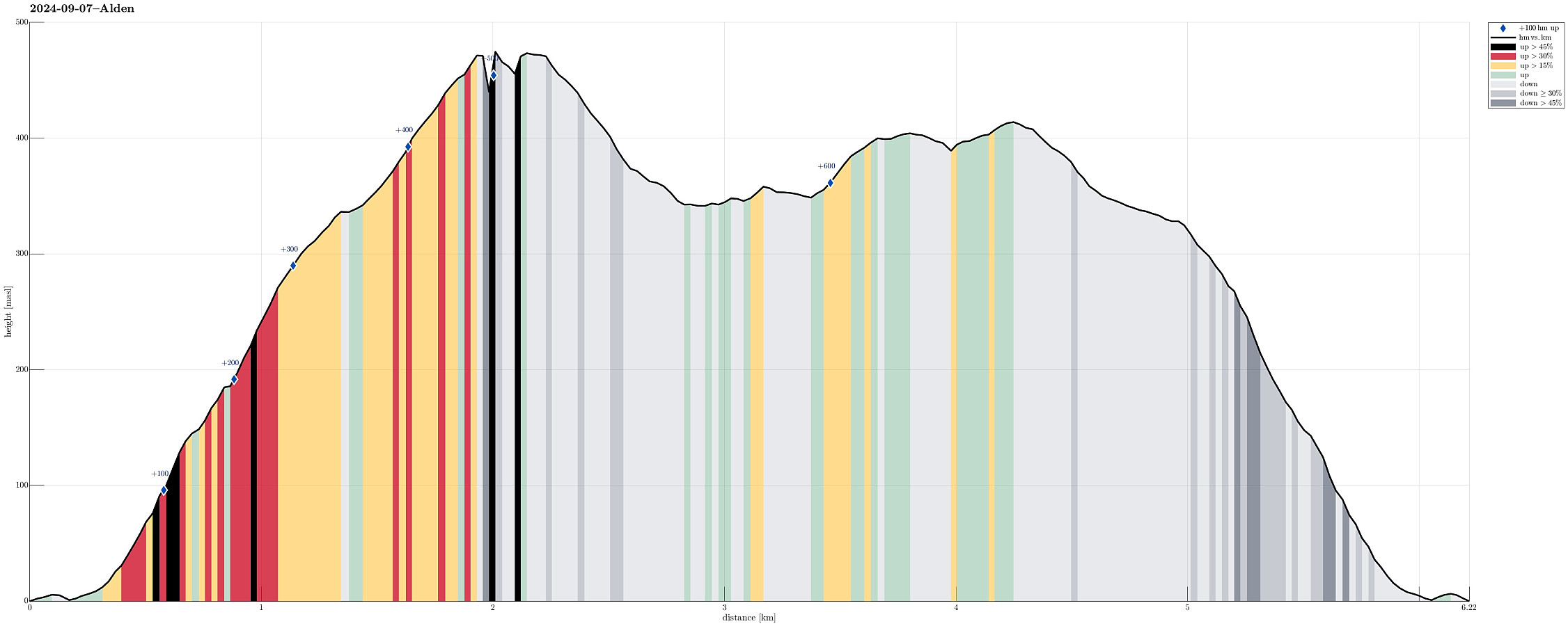 We had stayed on Værøyna over night and then could borrow a small boat to get over to Alden. We "parked" the boat at the main quay in Aldevågen and started our hike from there. Following the one trail that leads up to the top(s) of Alden, we made quick progress -- the terrain is very steep, but the trail is very good and easy to step up. Once up to about 300 masl, we headed towards the hightest peak on Alden, Instenova, in the East of the island. Following the main trail, we could nicely make it to the top without any difficulties. Clearly, one gets lots of great views from the heights on Alden -- very nice! :-) After our visit to Instenova, we then wished to also see "the other top", Ytstenova, on Alden. To get there, we crossed over the heights, passing by the >>>
Bike-hiking Landåsfjellet and more
- Dato:
- 01.09.2024
- Turtype:
- Blandet sykling
- Turlengde:
- 4:00t
- Distanse:
- 37,5km
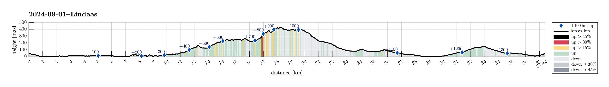 Somehow, I thought that this Sunday was the day for visiting Nattlandsfjellet and checking out the view-point right above the tunnel of Nye Sædalsveien. I got onto my eBike and biked around the south of Bønes, following the north shore of Nordåsvatnet. This brought me to Gamlehaugen, where I decided to interrupt my bike-trip for a short exploration of the area around the King's house. My first goal there was to get up to the small hill in the southeast of the mansion. I first thought that there would be a way to get there "directly", just to find that this little hill has some rather steep cliff on its west-side -- not high, but high enough to be an obstacle. Walking around, however, brought me to a path that -- while apparently not much used -- lead me easily and conveniently >>>
