Arkiv - dato
Arkiv - aktivitet
-
Annen tur (1)
- Kajakkpadling (1)
-
Annen vintertur (4)
- Trugetur (4)
- Fottur (740)
-
Skitur (4)
- Fjellskitur (4)
-
Sykkeltur (137)
- Blandet sykling (51)
- Gatesykling (9)
Arkiv - Etter geografi
"Peakbookvenner"


Lister jeg samler etter
-
Bergen ≥ 50m pf. og ≥ 100 m.o.h.
(87/89)
 97%
97% -
Most dominating tops of the Bergen peninsula
(68/75)
90%
-
Utvalgte topper og turmål i Bergen
(316/350)
90%
-
Alle topper i Bergen
(357/398)
89%
-
Opptur Bergen
(100/113)
88%
-
De syv fjell rundt Bergen
(6/7)
85%
-
Sund ≥ 50m pf.
(14/18)
77%
-
Os ≥ 50m pf.
(25/34)
73%
-
Søyler (fastmerker) i Bergen
(68/100)
68%
-
Fjell ≥ 50m pf.
(21/32)
65%

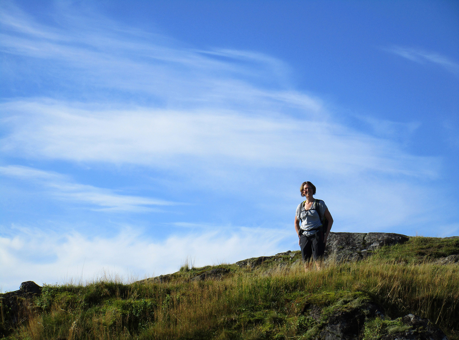
Hausdalshorgi (and Austefjellet) from Hausdalen
- Dato:
- 06.10.2019
- Turtype:
- Fottur
- Turlengde:
- 5:00t
- Distanse:
- 11,0km
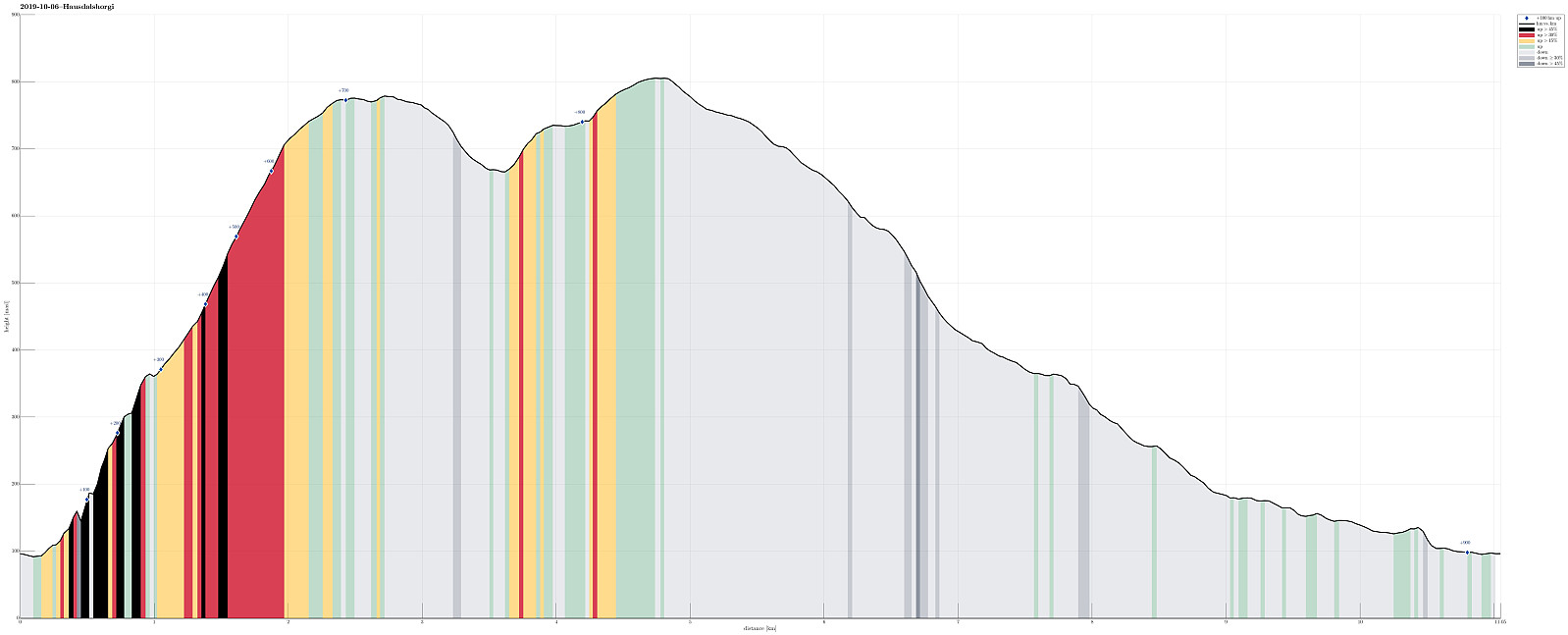 After completing a rather adventurous hike up and down Møsnuken the day before, we were ready for a new adventure! :-) For years, already, we were wondering whether one could hike Hausdalshorgi from "the bottom of" Hausdalen, also. After studying the map carefully, we decided to give this a try. It had appeared quite doable to hike up the southwestern ridge of Hausdalshorgi, at least from the tree line at about 350mosl. The major remaining question then was about how to get up to this point (N60°20′05″, E5°31′15″). The maps suggests one approach via Askestølen (hiking up a forest road from Samdal first and then continuing in the direction of Bjøllebotn). Since this would require a bit of hiking on roads (first along Hausdalsvegen, then along Lundagotnene), we wondered whether a more direct approach from Hausdalsvegen >>>
Møsnuken from Gåssand
- Dato:
- 05.10.2019
- Turtype:
- Fottur
- Turlengde:
- 5:00t
- Distanse:
- 12,5km
 Møsnuken is very much worth a visit, not only for those who live in or around Osøyro. Usually, one would approach Møsnuken from the west (via Tyssdalen), or via Borgafjellet from Os. Less common is the approach from the north, i.e., from Gåssand. Some longer time back, we already tried this once, but failed (we had ended up at the northern side of Krokavatnet and did not see any reasonable way to get over it). So we decided to give this adventure another try! :-) Taking E39 southwards from Bergen, we turned left in Søfteland (where there's a sign towards Gåssand). As soon as one crosses Oselva one continues on the relatively narrow road Gåssandvegen in northeastern direction. After passing through a small valley (Lona) between Raudlifjellet (on the left) and Åsen (on the right), >>>
Sauafjellet from Rolvsvåg
- Dato:
- 29.09.2019
- Turtype:
- Fottur
- Turlengde:
- 4:00t
- Distanse:
- 8,3km
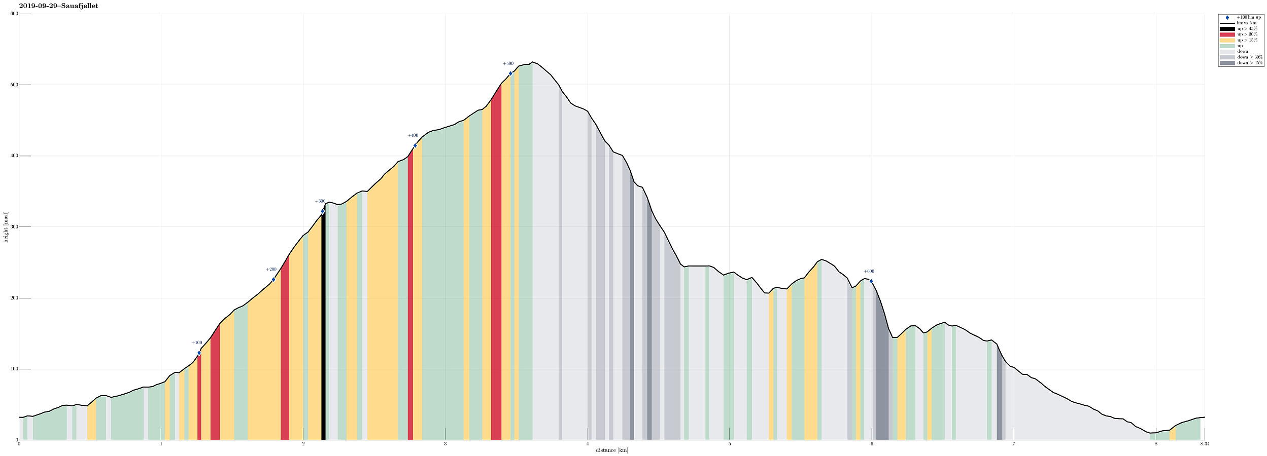 For a long time, we had set Sauafjellet aside, keeping it for "another day". Today, we decided to give Sauafjellet a try. To make this a proper hike, we discussed several variants, eventually arriving at the plan to approach Sauafjellet from its south (from Rolvsvåg). Driving northwards on the western side of Samnangerfjorden (following road 579), we parked where Setravegen meets Solbjørgvegen and started our hike along Setravegen until we had passed the industrial area at Rolvsvåg. There we found a forest road that rounds Raudsteinshaugen before then leading northwards into the direction Øykjadalen. At about 110mosl, where the forest road ascends on the eastern side of the valley, we left the forest road and continued upwards to reach the ridge in the east of Øykjadalen, >>>
Quick round-trip over Løvstakken
- Dato:
- 28.09.2019
- Turtype:
- Fottur
- Turlengde:
- 1:15t
- Distanse:
- 3,3km
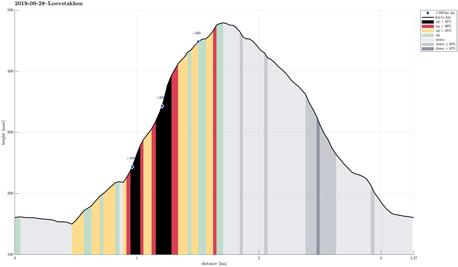 Aiming at something short, we decided to visit Løvstakken. To make this a bit interesting, we decided to park near Storavatnet at Krohnegården and then aim for the "diretissima" to Løvstakken (from Rosenlundveien). The new piece of this connection was the part between Storavatnet/Krohnegården, leading up to Rosenlundveien directly from Storavatnet (via Bustingen). Trying this connection for the first time, we found out that it's easy to find and straight-forward to follow: after first stepping up along the little road, which is serving two or three houses up there, one finds a trail at about 175mosl, which then connects to Rosenlundveien just a few meters from where the "diretissima" trail to Løvstakken starts. Definitely a good find, easing the hiking of a short >>>
Veten i Åsane
- Dato:
- 22.09.2019
- Turtype:
- Fottur
- Turlengde:
- 3:45t
- Distanse:
- 9,5km
 Since time was limited, we chose a hike not too far from Bergen and not long a hike, neither. Since we had talked about Veten (Veten i Åsane), we decided that we would hike it, once again. To add a bit of variation, however, we chose to approach it from the north, this time. We thus took the car from Bergen via Åsane along the E39 (into the direction of Knarvik). Before approaching the bridge, north of Åsane, however, we turned right onto road 5346 that leads to Steinstø. Shortly after, we turned left again and onto a narrow road that brings one to Hordvik. There, near Hordvik kindergarden, we parked and started our hike (in southern direction). We first followed a small road, right next to a little stream that comes down from Veten (on its eastern side), until we crossed E39 by >>>
Brøknipa from Skaftå
- Dato:
- 21.09.2019
- Turtype:
- Fottur
- Turlengde:
- 6:15t
- Distanse:
- 15,7km
 We took the car from Bergen to Osterøy (first along E16, then across the bridge). Right after crossing the bridge, we turned right (into the direction of Bruvik). Following Bruvikvegen, we soon after arrived at Skaftå, where we parked next to the road. We then walked a few meters in order to get started with our hike up to Brøknipa. When checking the information board at the beginning of the hike (right next to Bruvikvegen), we detected a dotted line that suggested that one could hike up directly to Utegardsnipa (instead of first going along Skaftådalen to Stølane before then turning back and up to the ridge that leads to Utegardsnipa). We thus adapted our plans to try out this route. We started "the usual way" (towards Skaftådalen), but at about 100mosl we found a little >>>
Gråsida from Gjelle to Hornaberg
- Dato:
- 08.09.2019
- Turtype:
- Fottur
- Turlengde:
- 6:45t
- Distanse:
- 19,6km
 Expecting nice September weather, we planned for a slightly longer hike, crossing Gråsida near Voss from one side to the other. In order to arrange for this, we agreed to coordinate this hike with friends, who would do the same hike, but in the other direction. The idea was to then exchange car keys at the meeting point so that each party could pick up a car at the end of the hike and drive back to Bergen. Our direction meant to start at Gjelle (south of Vossavangen) and to cross Gråsida towards Hornaberget in Bergsdalen. According to the plan, our friends started at Hornaberget and aimed for Gjelle, where we had parked our car (we had first taken road #5394 from Vossavangen towards Gjernes, before then driving up Giljavegen until we parked at about 285mosl, where a gravel road starts >>>
Fanafjellet from Rød
- Dato:
- 07.09.2019
- Turtype:
- Fjelltur
- Turlengde:
- 3:00t
- Distanse:
- 5,8km
 We had a bit of time and thinking, that even a small hike nearby could be nice, we headed for Fana and Fanafjellet (south of Bergen). At Fana, we then turned right and followed road #546 (in the direction to Krokeide, where the ferry to Austevoll leaves). The plan was to start from Rød and to find a trail up to Fanafjellet that four years earlier was the end of another hike near Krokeide . We thus parked near Rødshella and walked towards the place, where we assumed that the trail would come down. Passing by house #424 instead of house #422, we missed this trail-head by a few meters. Following some minor path through the forest, then, and following the rather step mountain-side there in southern direction, we ended up in the west of Rødsaksla instead. At about 80mosl, we first enjoyed a nice view over Fanafjorden, >>>
Drangsfjellet with Høgelikampen
- Dato:
- 31.08.2019
- Turtype:
- Fjelltur
- Turlengde:
- 3:00t
- Distanse:
- 6,6km
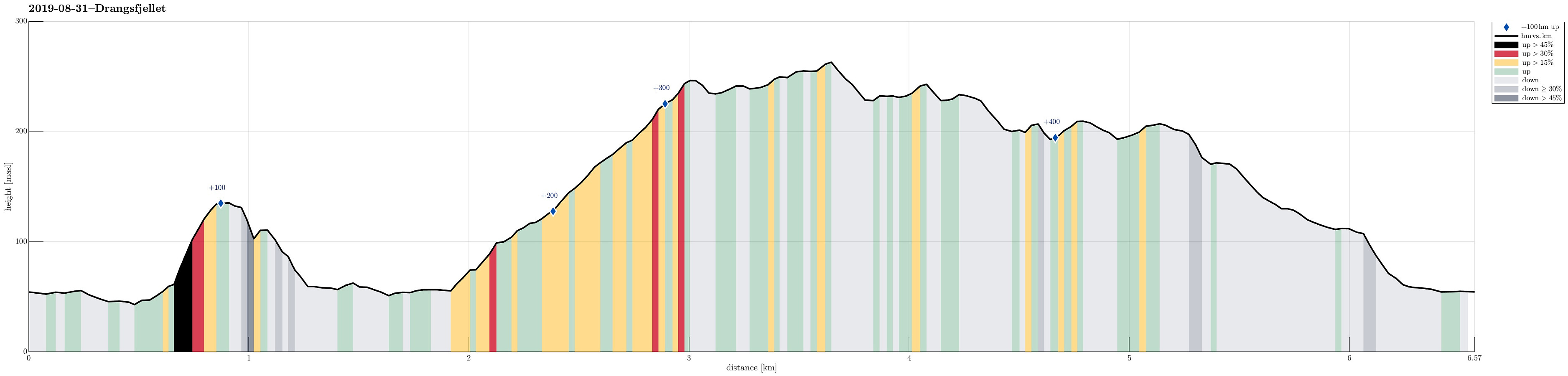 We left Bergen towards the south, passing by Fana and driving over Fanafjellet (road #5158). Near Sørstraumen, where road #5156 leaves to the left (in eastern direction), leading to Lyseklosteret before continuing towards Ulven, we turned right, following along the coast of Seiasundet. South of Søvik, where the road leads away from the sea, we then took a sharp turn to the right (towards Drange). Before getting to Drange (and just before getting to Langavatnet), we parked the car right next to the road. Instead of starting our hike into the forest from there, however, we first followed the road a bit further (to Indre Drange, actually). There, we found a good place to leave the road and start our first ascent (up to Fjærhovda). While it was not difficult to find our way up there, one >>>
Blægja
- Dato:
- 29.07.2019
- Turtype:
- Fottur
- Turlengde:
- 7:00t
- Distanse:
- 10,1km
 After day #5 of our five days hike through Breheimen , we decided to a "bonus hike". After driving mostly westwards from Breheimen, we stayed in Førde for the night (our goal was to hike up Blægja the next day). The next morning, after driving further westwards from Førde, following road #609 along the southern coast of Førdefjorden, we parked between Hestvika and Rørvika near an information board, right next to the road. After walking down the road for a short stretch, we easily found the trail-head, leading southwards from the road. After first following a forest road for a short distance, the trail leaves to the right and into the forest (once you find it, it's then easy to follow). The path leads upwards, through the forest, staying on the eastern side of a valley, where water from Nipevatnet and Tobbedalsvatnet >>>
