Heihillerhornet, Kjerringafjellet, and Ottanosi (26.04.2025)

| Startsted | Bygdastølen P (340moh) |
|---|---|
| Sluttsted | Bygdastølen P (340moh) |
| Turtype | Fottur |
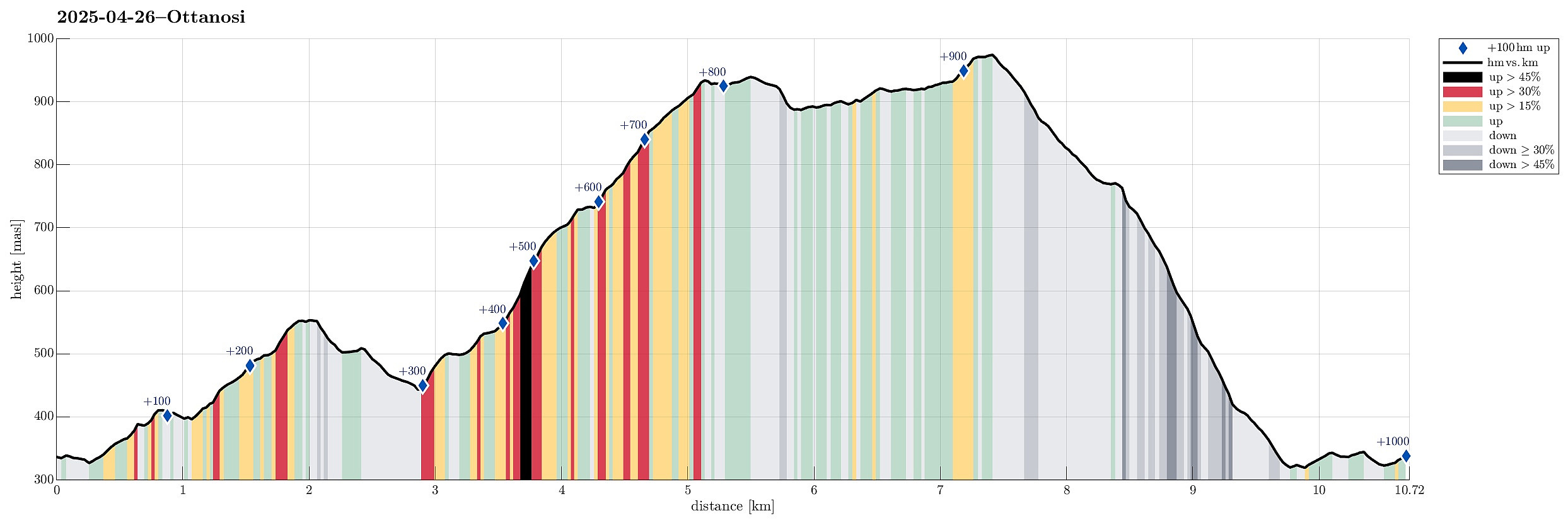
| Turlengde | 5t 30min |
| Distanse | 10,7km |
| Høydemeter | 994m |
| GPS |
|
| Bestigninger | Heihillerhornet (558moh) | 26.04.2025 |
|---|---|---|
| Kjerringafjell (938moh) | 26.04.2025 | |
| Ottanosa (976moh) | 26.04.2025 | |
| Andre besøkte PBE'er | Bygdastølen P-plass (340moh) | 26.04.2025 |
| Minnetavle "Vi møtes på Kafeen" (925moh) | 26.04.2025 |
Trip Summary
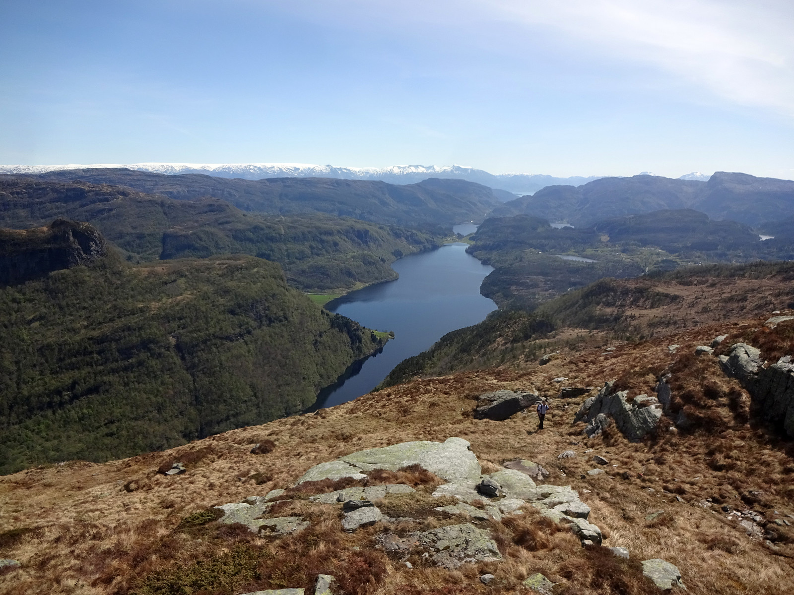
We expected nice weather and thus planned for a nice hike! :-) We took the ferry from Hatvik near Os in the south of Bergen to Venjaneset in Fusa. From there, we first drove to Eikelandsosen and then to Holdhus, where we left road 48 to get up to the parking place at Heihillervegen (one pays some road fee for driving up there: NOK 75 plus about the same amount "on top" for "lagring og oppslag" as well as for "fakturagebyr"). Our first goal was to hike up to Heihillerhornet and so we "retreated" from the parking place a short stretch along the road to the place, where the trail starts (there's a sign, also). After first finding the trail head, we still managed to get off the trail within only meters from the road! :-) Instead of heading further eastwards, first, we immediately started to head northwards (into the direction of Heihillerhornet). Soon, however, it became clear, that some cliffs were between us and the top, which even weren't easy to "just walk around". We thus gave in to this particularity of the environment, there, and took our detour towards the East, where we eventually got back on the trail. While our off trail route for sure was no short cut, it still was nice to walk along (right underneath) some pretty spectacular cliffs! :-) Back on the trail, thoughl it certainly became nice and easy, again, to make progress towards the (first) top, Heihillerhornet. Up there, we then could enjoy some very nice views, already, including such to Kjerringafjellet (our hiking goal #2) and Ottanosi (goal #3). To continue to the saddle from which we wished to start our ascent to Kjerringafjellet, we then walking "diagonally" in (roughly) northeastern direction. Once at the saddle (near Søprleitet), we then needed a short southwards detour to get up to the southern ridge of Kjerringafjellet. Once up there, however, making further progress was nice and easy (first without a trail, though). At about 570 masl, we then connected to the marked trail up to Kjerringafjellet. Following this nicely marked trail then helped a lot to find the right spots for ascending this southern ridge of Kjerringafjellet, which, in several places, is characterized by some significant steps in the terrain, amounting to cliffs that cannot be reasonably traversed in many places. Given the nice trail, however, all of this became just nice (yes, it's a bit steep in places, but without any real difficulties). Not only from the top of Kjerringafjellet, but already from many places during the ascent, we enjoyed wonderful views in many directions! After a nice, short lunch break on Kjerringafjellet, we then continued into the direction of Ottanosi. First, we had to get down to the connecting saddle, which actually was quite a bit of fun on the snow! :-) Then it was mostly just walking over the heights of Ottanosi to get to its top. Before reaching the highest point, however, we briefly looked at the plate, which now can be found there to remember an attempt near the end of WWII to sabotage submarine activities in Bergen. Not far from there, we then reached the top of Ottanosi, enjoying more great views also from there, obviously. :-) Down from Ottanosi, and back to our car, we then followed the main trail, which also is nicely marked. This is quite helpful, again, since at several places some substantial cliffs could also make the descent difficult. Right south of Vindestegtjørna, for example, one finds a short section that is covered by metal stairs (with some firmly mounted rope to hold on to). Within not too long, we made it down to Bjørndalstølen and from there down to Åreidselva. After crossing over the stream, using a convenient bridge, we then only had to walk back the forest road. Back at the car, we shared our satisfaction with the nice weather and the nice hike! :-)
Photos
Selected photos are available as Google photo album.
Useful Resources
See also the related FB-page Hiking around Bergen, Norway.
Petter Bjørstad has a useful page about Ottanosi and also web page WestCoastPeaks.com provides useful information about Ottanosi, Kjerringafjellet, and Heihillerhornet.
Web page UT.no from the Norwegian Trekking Association recommends a direct hike to Ottanosa.

Kommentarer