Gulltjørna from Risnes (18.06.2023)

| Startsted | Risnesvegen (60moh) |
|---|---|
| Sluttsted | Risnesvegen (60moh) |
| Turtype | Fottur |
| Turlengde | 3t 00min |
| Distanse | 6,6km |
| Høydemeter | 688m |
| GPS |
|
| Bestigninger | Ramfjellet (428moh) | 18.06.2023 |
|---|
Trip Summary
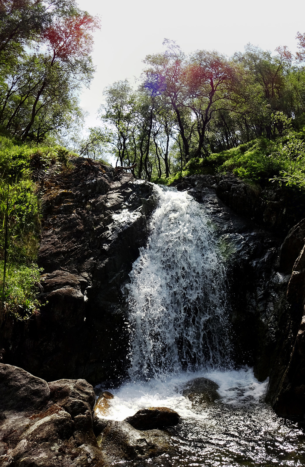
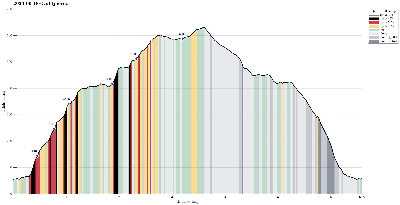
We liked the idea to paying Gulltjørna another visit and we also liked the idea to do it, again, from the north. Following E16 into the east of Bergen, we left the main road near Romslo in order to connect to the old, narrow road that would bring us closer to Risnes. We found a spot where we could park alongside the road just a short stretch before actually getting all the way to Risnes. From there, we walked first for a short stretch along the road in order to get to our starting point of the actual hike. Right next to the bridge over the stream that comes down there through Risnes, we saw that one could use the steps of the water processing building there to get a bit further up (and away from the road). Where the stairs end, however, one needs to revert to actual hiking (there it's more like stepping steeply upward through the forest). Even though quite a bit steep there, it was no problem to ascend some 50 height meters before the terrain gets a little less steep. In wet conditions, however, it may be too steep there, maybe. Once at about 125masl, however, making further progress was easier (and more like normal hiking, also). Some approximately 50 additional height meters further up, we even connected to something that also could be called a simple trail. Following this trail (or "trail") further upwards along the western hillside of Krånuken was then nice and it was not too difficult to actually find the trail. Above some 250masl, the terrain gets steeper, again, and it is helpful to not loose the trail there, which is following kind of a ledge in the hillside. This brings on up to about 350masl and a nice little waterfall, where one can then also cross over the stream conveniently. Note that this waterfall is above the much bigger one, which is about 50 height meters further below. There, as it seems, the terrain is too steep to make any reasonable attempt to cross over to the western side of the stream. Up at the small waterfall, however, this is nice and easy, and also making further progress on the other side (up through the forest to some heights at about 400masl) is straight-forward. At about 400masl, then, the forest opens up for a wet (and comparably flat) area in the west of the stream. Walking around this wet are (in its west), we got close to the stream, again. There, we thought that it was necessary to gain some additional height meters and thus we ascended to another small height (this one at about 485masl) in the northwest of the stream. From there, it was then first kind of flat into the valley, again, before we used the open area where minor streams come down from the west to make the still missing height meters. Once up to about 600masl, we then had Gulltjørna right in front of us, with just a minor walk along the hillside away. We then enjoyed a nice break at Gulltjørna. Soon, however, we started to think about the possibility of later facing some weather change (with a chance for thunders and lightnings). Thus, we did not stay at Gulltjørna all too long, but instead started our descent back to Risnes rather soon. We first ascended to the northeastern ridge of Gråfjellet in the northwest of Gulltjørna, before then descending along this ridge towards Ramfjellet. The goal was to find a connection to Risnesrinden (and to descend it then to Risnes). This time, we were determined to actually find this connection (a not get diverted to the steep left of the ridge has we had experienced the other time that we descended from Ramfjellet). After passing by the cabin in the northeast of Ramfjellet, we descended to about 315masl, where we checked the map! Well possible that we would have been "tricked" again by the terrain there, thinking that we had already connected to Risnesrinden. Instead, however, we found a way to get around the cliffs between 275 and 300 masl that leads "around the corner" and then "diagonally down" in southern direction. This way, we made it well to Risnesrinden. The more we then descended Risnesrinden, the more we had an impression to step down a simple trail, also. Soon after, we then arrived at the road Risnesvegen, again, and walking back to the car took only a few additional minutes. While we never really had the impression that the thunders that we heard were anywhere near, we still were satified that we had avoided any "funny" weather experiences while on higher grounds near Gulltjørna!
Photos
Selected photos are available as Google photo album.
Useful Resources
See also the related FB-page Hiking around Bergen, Norway.

Kommentarer