Stongfjellet and Skolmen (15.04.2023)

| Startsted | Hovdavegen (245moh) |
|---|---|
| Sluttsted | Hovdavegen (245moh) |
| Turtype | Fottur |
| Turlengde | 4t 30min |
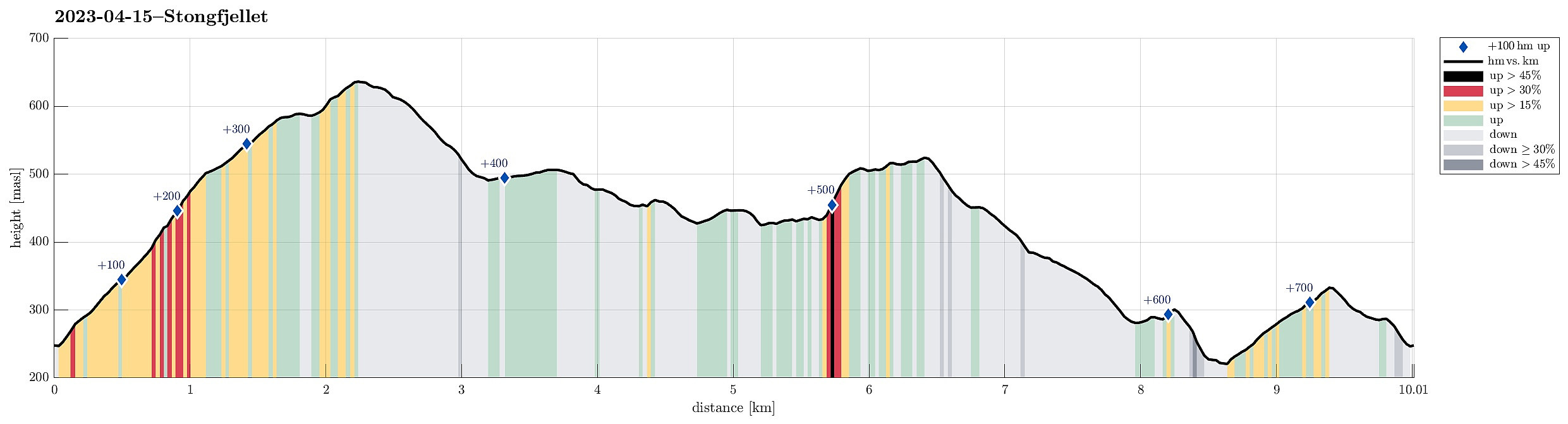
| Distanse | 10,0km |
| Høydemeter | 728m |
| GPS |
|
| Bestigninger | Skolmen (528moh) | 15.04.2023 |
|---|---|---|
| Stongfjellet (640moh) | 15.04.2023 | |
| Andre besøkte PBE'er | Hovdavegen parkeringslomme (244moh) | 15.04.2023 |
Trip Summary
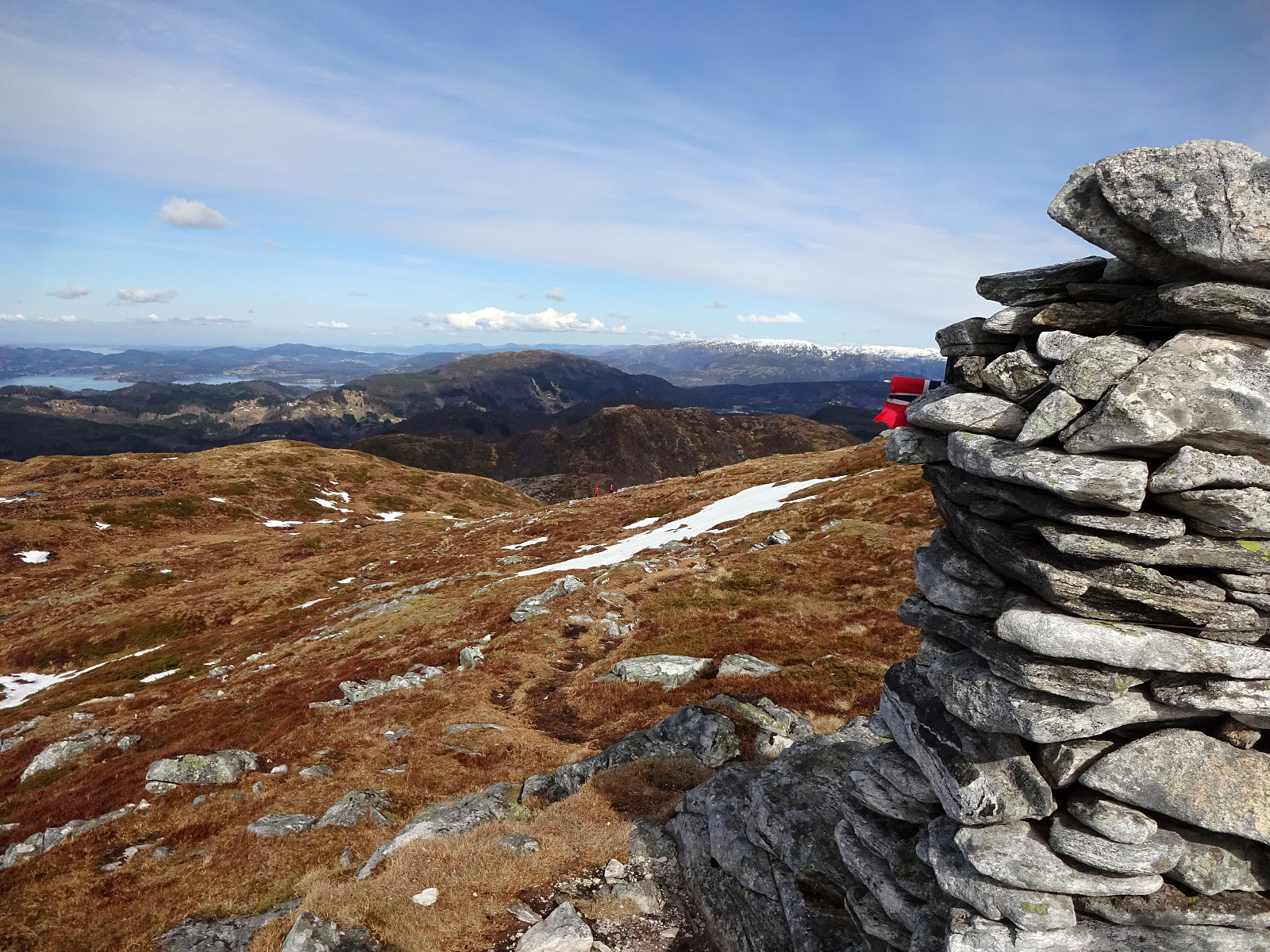
We first had considered Høgafjellet on Osterøy, but since we expected -- probably for good reasons -- quite a bit of snow on Høgafjellet, we eventually decided against Høgafjellet. Since we already thought about Osterøy, we chose Stongfjellet, instead. To get there, we drove to Osterøy (via the bridge to Osterøy), continuing through the tunnel on Osterøyvegen. At Gongerinden, we left Osterøyvegen, heading towards Gjerstad on Gjerstadvegen. Once through Gjerstad (and crossing over the stream), we continued via Solbjørg and Solbjørgsdalen. We then took Hovdavegen, passing by Låstadvatnet in its south and continuing further upwards in southeastern direction. Very close to the saddle, before reaching Hovdo at the end of the road, we parked right next to the trail-head. From Hovdavegen, we then followed the trail up to Stongfjellet, passing by Bergsfjellet, Grassdalen, and Midtstølen on our way up. Stongfjellet, even though not really high, offers beautiful views in all directions! After enjoying ourselves for a short break on Stongfjellet, we continued our hike (next goal: Skolmen). Since the northern/northeastern side of Stongfjellet is a bit steep (and since we correctly expected quite some snow there, also), we decided to walk down the southeastern ridge of Stongfjellet (into the direction of Geitrheimssetret). Once down enough, we left the trail, "turned around", and entered Lonadalen from the south. To get further north (and eventually up to Skolmen), we decided to stay on the western side of Lonadalen, eventually getting through Fagerstølsvatnet (in the east) and Byheimsvatnet (in the west). Even though this hike along Lonadalen was mostly without a trail, it was easy-going and nice! Crossing the stream that connects Fagerstølsvatnet and Byheimsvatnet, we continued to Fagerstølen, where we enjoyed a nice lunch break. From Fagerstølen and up to Skolmen, we first ascended steeply (and first also without a real trail), before then reconnecting with the trail that comes up from further south west of Fagerstølsvatnet. From Skolmen, we then took a simple trail down its southern ridge (towards Svabotn). Once down to 450masl, and then starting to cross over Svaena, it was not that clear where the trail is. Eventually, we could still find it (again) and get down to the spot (west of Byheimsvatnet), where one can cross over the stream through Svabotn. Hiking further down (through Steindalen) was then straight-forward. Near Antunkvilet, we then cut through towards Kleivane, then descending towards Hagebø. Instead of stepping out and onto the road at Hagebø, we entered the valley that leads up in southern direction (kind of parallel to road Hovdavegen) in the west of Oksli. After crossing over the saddle, we headed towards the trail that we initially had taken up to Stongfjellet. At about 285masl, however, we met a fence (with barbwire on top!) that did not look easy enough to cross. Thus, we followed the fence westwards until we found a spot, where crossing it was easy. Then, it was just a few meters until we met the trail, taking it then down to the road and our car. All in all, a very nice spring hike! :-)
Photos
Selected photos are available as Google photo album.
Useful Resources
See also the related FB-page Hiking around Bergen, Norway.
Petter Bjørstad has a useful page about Stongfjellet and also web page WestCoastPeaks.com provides useful information about Stangfjellet.
Web page UT.no from the Norwegian Trekking Association recommends the same way up to Stongfjellet.

Kommentarer