Gaustadfjellet, Litlafjellet, Bårafjellet, Øyjordsfjellet (04.09.2022)

| Startsted | Ådlandsvegen (45moh) |
|---|---|
| Sluttsted | Ådlandsvegen (45moh) |
| Turtype | Fottur |
| Turlengde | 6t 30min |
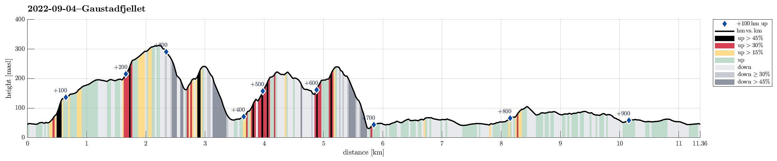
| Distanse | 11,4km |
| Høydemeter | 917m |
| GPS |
|
| Bestigninger | Borefjell (227moh) | 04.09.2022 |
|---|---|---|
| Gaustadfjellet (316moh) | 04.09.2022 | |
| Litlafjellet (245moh) | 04.09.2022 | |
| Øyjordsfjellet (243moh) | 04.09.2022 |
Trip Summary
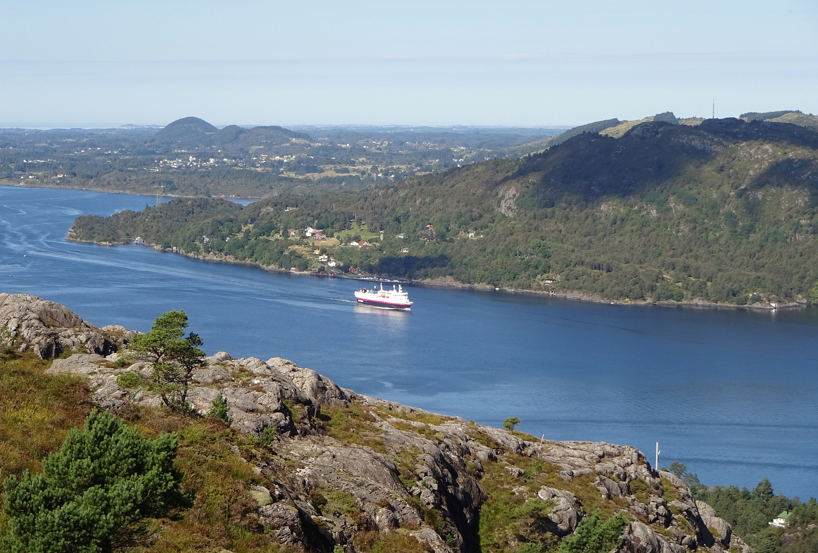
Looking forward to a nice day, we decided to pay Gaustadfjellet on Holsnøy a visit. To get there, we crossed Krossnessundet right after driving over Nordhordlandsbrua, north of Bergen. Then, we followed road 5310 northwestwards, kind of parallel to Radfjorden on our right side. Since we wished to start our hike from the southeast, traversing all of Gaustadfjellet (and further), we first needed to find a proper parking place along Ådlandsvegen. After a bit of back and forth, we managed to park properly along this rather narrow road. We then followed a not really well visible trail to the southern ridge of Gaustadfjellet (Storhøyden). From there, then, we could use a nice trail that extends over most of this ridge. It's actually a very nice alternative to the otherwise shorter ascent to Gaustadfjellet from the northeast, offering nice views, predominantly towards the northeast, across Radfjorden, and towards the southwest, across Holsnøy. Soon we had arrived on the top of Gaustadfjellet, enjoying the wonderful all-around views from there (including some nice views towards Eldsfjellet, also). From Gaustadfjellet, our goals was to continue further in northwestern direction; first towards Litlafjellet. In order to get there, one needs to descend into Litlaskaret, first, before then ascending to Litlafjellet on the other side. The western side of Gaustadfjellet is quite a bit steep and one needs to watch out for a good route to get down there. Looking carefully, however, will reveal some markers that ease the process of finding a suitable route down. Up to Litlafjellet on the western side of Litlaskaret, then, is easy, again, following a proper trail. From Litlafjellet, the goal was then to continue to Bårafjellet. Both descending from Litlafjellet and ascending to Bårafjellet can be done on proper trails (it is a bit steep, though, so slippery conditions may pose some challenges). Once on Bårafjellet, we still wished to do one more top, Øyjordsfjellet. From Bårafjellet, one can follow a nice trail (mostly in northern direction), which eventually leads down to Øyjordi in the northeast of Bårafjellet. After first following this trail, we then turned left and continued towards Øyjordsfjellet without a trail. Ascending via the northeastern side of Øyjordsfjellet was not problematic at all, just without a trail. Once on Øyjordsfjellet, though, our hike started to develop into a little adventure. Our idea was to head back to the car on the southwestern side of all the tops which we had traversed, not on the northeastern side, where the street (Ådlandsvegen) is. That's all fine, but descending directly from Øyjordsfjellet (in southwestern direction) turned out to be more difficult than what really was fully pleasant. Especially the lower half of this descent turned out to be significantly steep, requiring a bit of back and forth, as well as the use of our hands, to actually make it down into the valley below. There, where also a power line is passing by the tops in the northeast, we first found ourselves in a bit of a "jungle". It only took us a couple of minutes, however, to get on top of the "jungle", again. We then also found a trail (or a "trail", maybe) on Mjåvatsrinden, which we then followed into the direction of Litlafjellet, passing by Bårafjellet on our left. Near Litlafjellet, we reconnected (for a short stretch, only) with the trail that we had taken from Litlafjellet to Bårafjellet. After only a few meters, however, we left this trail, again, following another one that leads down to Kvernavatnet. Passing by this lake, then, on its northeastern side, lead us further southeastwards, towards Åsen. Following "our" trail further, half the way up to Åsen, on its southwestern side, we connected to Gaustadstigen, in the southeast of Åsen, where we considered to "cut" across Dalen to get back to the car. Instead, we followed "our" trail even further in southeastern direction until we stepped out on Ådlandsvegen, which we then followed back north to the car. All in all, this hike was a bit more demanding than originally expected. But visiting Gaustadfjellet (and its "sister tops" in the northwest of Gaustadfjellet) is definitely a very nice hiking opportunity with lots of great views!
Photos
Selected photos are available as Google photo album.
Useful Resources
See also the related FB-page Hiking around Bergen, Norway.
Web page WestCoastPeaks.com provides useful information about Øyjordsfjellet, Borefjellet, Litlefjellet, and Gaustadfjellet and also Petter Bjørstad has a useful page about Gaustadfjellet and a useful page about Øyjordsfjellet.
Web page UT.no from the Norwegian Trekking Association recommends a similar hike.

Kommentarer