Nice hike around Hisdalsvatnet (09.10.2021)

| Startsted | Krokeide (45moh) |
|---|---|
| Sluttsted | Krokeide (45moh) |
| Turtype | Fottur |
| Turlengde | 4t 45min |
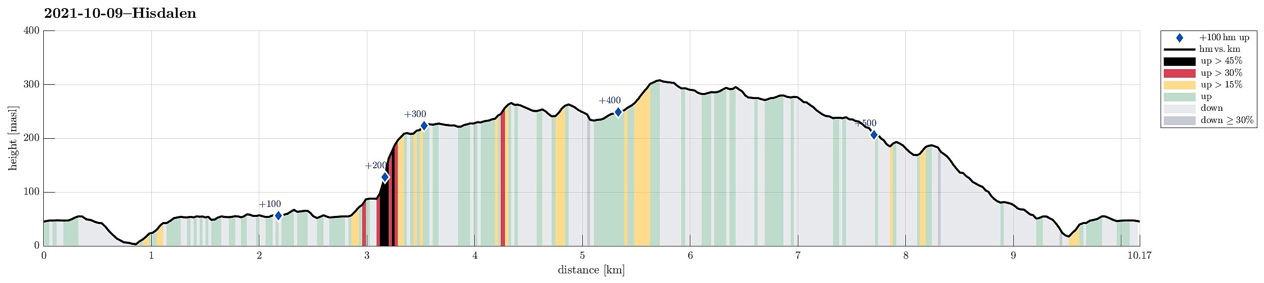
| Distanse | 10,2km |
| Høydemeter | 579m |
| GPS |
|
| Bestigninger | Folldalshaugane (300moh) | 09.10.2021 |
|---|---|---|
| Lyseskarfjellet (313moh) | 09.10.2021 | |
| Storemunken (191moh) | 09.10.2021 | |
| Tverrfjellet (268moh) | 09.10.2021 | |
| Andre besøkte PBE'er | Storemunken utsiktspunkt (189moh) | 09.10.2021 |
Trip Summary
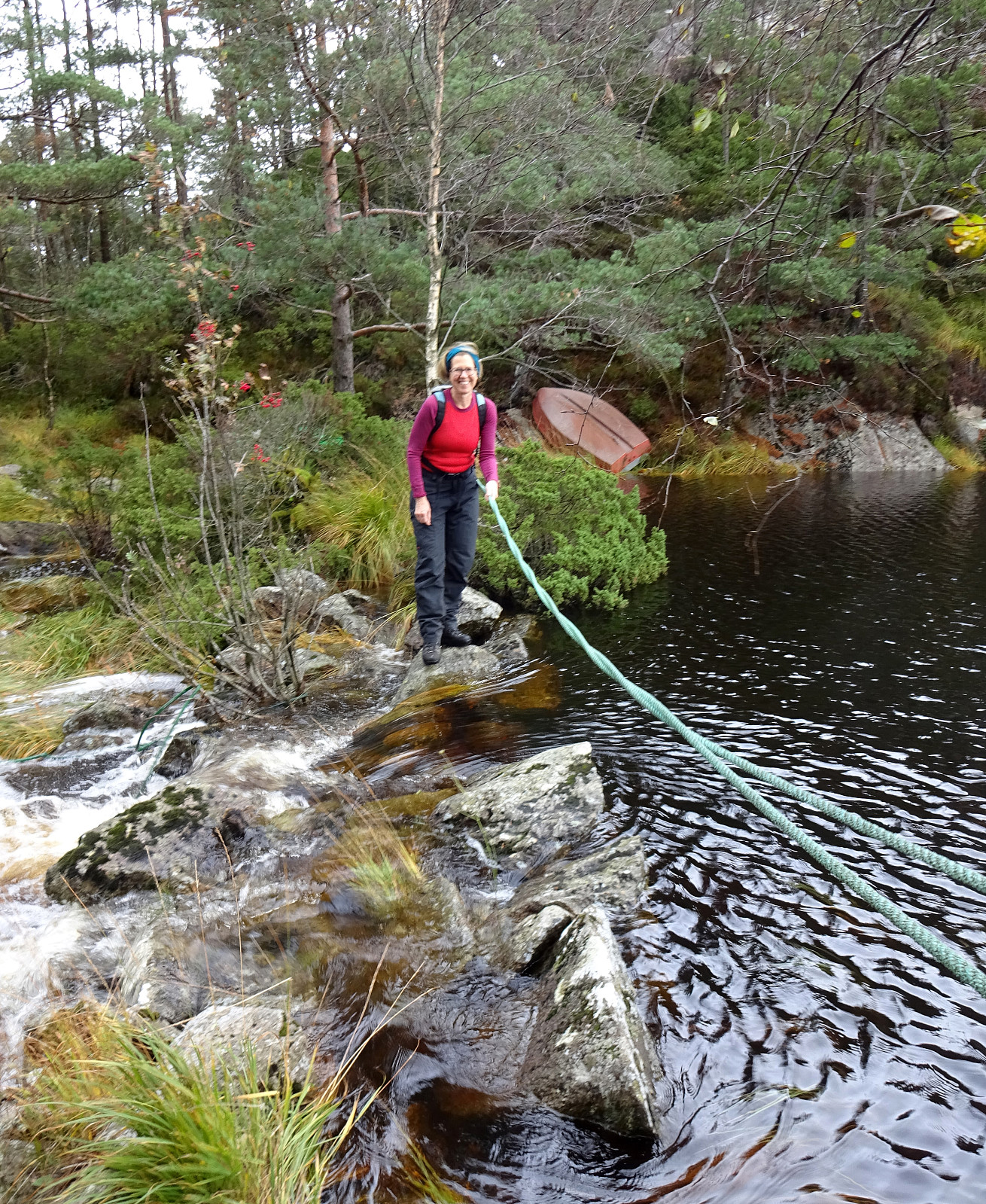
The weather forecast was OK and it looked like there was a good opportunity for a nice hike in the neighborhood. For a longer time already, the Hisdalen nature reserve had (silently) recommended itself and so we decided to pay this somewhat separated part of Bergen ("separated" in the sense that it's kind of "behind the hills of Fanafjellet") a visit. We took the car via Fana to Krokeide, where we parked next to the road (near the saddle before one drives down to the ferry terminal at Krokeide). We then walked (first along a minor road) into the direction of Austrevågen (in eastern direction), before continuing along the forest road towards the southwestern end of Hisdalsvatnet. There, our goal of crossing the stream out of Hisdalsvatnet was challenged by the large volume of water that rushed down from there into the direction of Austrevågen in western direction. Luckily, someone had mounted a rope across the stream there. While still there was little chance to cross over without stepping right into the stream, at least one could hold on to the rope, thus minimizing the chances for being washed away with the water! :-) Once on the other side, we found a minor "trail" and following it, we made good progress in eastern direction along the southern shore of Hisdalsvatnet. After passing by all of Hisdalsvatnet, we continued a little further (right next to the stream) into Hisdalen (until we were somewhat close to Kampen, then in the east of us). There, we left the valley, first into the direction of Storamyra between Insta Ospevikfjellet and Kampen. When studying the map up front at home, we got the impression that ascending to Kampen from Storamyra could be possible, while we also had seen that this side of Kampen (as also others!) is quite steep in many places. Approaching Kampen, we then quickly saw that significant portions of this hill-side actually are cliffs that we impossible to scale (without climbing gear, at least). Still, we had the impression that in between the cliffs a possibility for an ascent remained possible. We thus gave it a try and started to step up with cliffs to the left as well as to the right. Some 25 height meters up through the forest, we then faced the first (minor challenges), with a few stretches where we (a) had to explore a bit in order to find a route (a bit of back-tacking included) and (b) needed to use our hands in addition (as well as good bit of care, also) to sneek through the more difficult sections and continue further upwards. Approximtely 25 height meters further up, however, the terrain became easier again and eventually our ascent to Kampen became easy and enjoyable on this upper stretch. In fact, one can enjoy some nice views (down to Brattholmen and across) from Kampen, when finding the right spot with a "window" between the trees. From Kampen, we then continued across Stokkfjellet into the direction of Tverrfjellet (all that nice and easy, while without a trail, though). From Tverrfjellet, we then headed into the direction of Lysekarfjellet (via Midtfjellet). While it is fully possible to find a suitable passage from Tverrfjellet to Midtfjellet and from there to Lysekarfjellet, one also can meet some steeper sections that require a bit of walking a round them (the northern side of Tverrfjellet, for example, is quite steep). From Lysekarfjellet, we then headed back towards Krokeide, following some trails over the "high ridge" of Fanafjellet. After passing over Folldalshaugane along this return walk, we opted for the tail across Skarafjellet even though the main trail (now Jubileumsstien!) follows a somewhat more northern route. Walking furhter down (also over Brattebergshaugen), we reconnected with Jubileumsstien in the vicinity of Storemunken. There, instead of immediately continuing further downwards along Jubileumsstien, we first include Storemunken and the look-out point there. Then, we "just" followed Jubileumsstien down and back to our car along road Austrevågen. The nature reserve Hisdalen is somewhat a "forgotten" gem in the south of Fanafjellet and one really gets the impression that nature is "left alone" there quite a bit -- definitely a worthwhile goal for a hike not far from Bergen!
Photos
Selected photos are available as Google photo album.
Useful Resources
See also the related FB-page Hiking around Bergen, Norway.
Web page WestCoastPeaks.com provides useful information about Lyseskarfjellet and Høgeåsen and also Petter Bjørstad has a useful page about Fanafjellet.
On Bergentopp 200 there is a page (in Norwegian) about Lyseskarfjellet.
Web page UT.no from the Norwegian Trekking Association recommends the first stretch of Jubileumsstien across Fanafjellet.

Kommentarer