Liatårnet from Fjell Festningen (30.12.2020)

| Startsted | Søre Fjell (40moh) |
|---|---|
| Sluttsted | Søre Fjell (40moh) |
| Turtype | Fottur |
| Turlengde | 4t 00min |
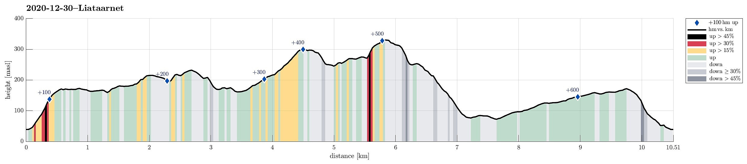
| Distanse | 10,5km |
| Høydemeter | 632m |
| GPS |
|
| Bestigninger | Liatårnet (341moh) | 30.12.2020 |
|---|---|---|
| Skitnafenet (239moh) | 30.12.2020 | |
| Andre besøkte PBE'er | Kanontårnet (Fjell Festning) (175moh) | 30.12.2020 |
Trip Summary
Even though it was already a little later on the day (not a great lot of daylight left), we still wished to make a nice hike somewhere in the neighborhood. We then arrived at the following: first, we would ascend to Fjell Festningen (from Søre Fjell), then walk over to Pyttane and Liatårnet, before eventually returning via Fjell Festningen, again. And so we did it. :-) After using road 555 from Bergen towards Sotra (in western direction), we turned left (southwards) on Sotra, arriving in Fjell soon after that. Continuing along road 560 further southwards (from Fjell for about half a kilometer), we soon came to Søre Fjell, where we found a parking place right next to the road. From there, we followed a properly marked trail (in eastern direction), ascending to Fjell Festningen within short time. After exploring Fjell Festningen a little bit, we continued along a simple road (into the direction of Klakkane, i.e., in northeastern direction). Before actually getting to Klakkane, we left this road, heading more in eastern direction from there. After passing the power line, which runs north-south there, we connected with a trail that would lead further into the direction of Vardafjellet. Instead of actually going "all the way" to the "highest top" of Vardafjellet, we turned into a more southeastern direction once we had ascended to the ridge in the south of Vardafjellet (in order to continue further eastwards in the south of Bildøyvatnet). In the south of Bildøyvatnet, we then reconnected with the trail, which there heads upwards (in eastern direction), just north of Skitnafenet. Instead of further following this trail, however, we decided to "ascend" all the way up to Skitnafenet and enjoy the view from up there! :-) From Skitnafenet, we then descended into the direction of Lantafjellvatnet. Before getting there, we climbed a minor cliff (in the middle between Skitnafenet and Lantefjellvatnet). Thereafter, we desceded first further (in eastern direction, passing by Lantefjellvatnet in its north), before reconnecting with the trail that then lead us to the access road of Pyttane. Once on this access road, we first followed it (overall in southern direction) through a few of its turns (up to about 230mosl). There, then, instead of further walking up the road, we left it (to the right, i.e., in southwestern direction) and continued along the northern ridge of Pyttane. After ascending to about 300mosl, we turned a bit more westwards in order to access a nice look-out point there (some 250m in the northwest of the northern tower of Pyttane). There, we then had the idea to skip the final stretch up to the towers of Pyttane and instead connect to Liatårnet via Pyttavatnet (in the west of Pyttane). Due to the rather steep western flank of Pyttane and the fact that we hadn't studied the terrain on the map ahead of time, we weren't entirely sure whether this connection actually would be possible. But after first finding a suitable place for the descend down to Pyttavatnet, we regained all optimism that also the further continuation would be possible. We rounding Pyttavatnet in its northwest, we walked along Brendhelleren (on its eastern side) to get to Tårnavatnet. Passing by Tårnavatnet (also on its western side), we then reconnected with the tail that leads from Pyttane to Liatårnet. Completing the (for a while steep) ascend to Liatårnet was then easy from there. After enjoying the views from Liatårnet for a moment, we continued our hike (also to avoid getting too much into the dark later). Instead of taking the main trail down (first northwards from Liatårnet, then taking a sharp turn back towards the southwest, descending below the steep western side of Liatårnet), we continued southwards from Liatårnet (into the direction of Høgafjellet), followed by a steep (but very nicely possible) descent at the south end of Liatårnet. Instead of continuing along this trail then (which would have brought us to Høgafjellet), we turned right, i.e., in northwestern direction (without a trail). This brought us back to the main trail up and down Liatårnet (in its west). We then took this trail down (south of Litlatårnet) to the road that connects to a shooting range a little further north (north of Litlatårnet). We then walked this road out (in western direction), crossing also over Ytsta Elva, before turning right (in northern direction) in order to connect back to Fjell Festningen. After passing by Gyravatnet (in its west), we got up to Kanontårnet (again), but this time from its southeastern side. We then enjoyed a little snack at Kanontårnet, enjoying the nice evening there. When then descending the same trail that we first had taken up there, a headlight became nicely useful due to the darkness. All in all, we really enjoyed this hike quite a bit -- maybe in particular the discovery of this north-south connection underneath the western cliff of Pyttane.
Photos
Selected photos are available as Google photo album.
Useful Resources
See also the related FB-page Hiking around Bergen, Norway.
Web page WestCoastPeaks.com provides useful information about Liatårnet
and also Petter Bjørstad has a useful page about Liatårnet.

Kommentarer