Livarden and Slettegga from Bontveit (31.10.2020)

| Startsted | Bontveit (305moh) |
|---|---|
| Sluttsted | Bontveit (305moh) |
| Turtype | Fottur |
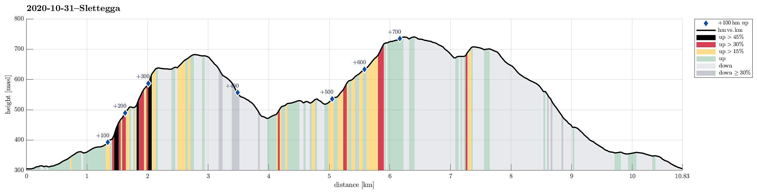
| Turlengde | 3t 30min |
| Distanse | 10,8km |
| Høydemeter | 780m |
| GPS |
|
| Bestigninger | Livarden (683moh) | 31.10.2020 |
|---|---|---|
| Nobbane (711moh) | 31.10.2020 | |
| Slettegga (742moh) | 31.10.2020 | |
| Tverrmeisa (541moh) | 31.10.2020 | |
| Andre besøkte PBE'er | Bjørnastølen (376moh) | 31.10.2020 |
| Bontveit parkering (304moh) | 31.10.2020 | |
| Domus Medica (353moh) | 31.10.2020 | |
| Fjellro (privat) (380moh) | 31.10.2020 | |
| Hjelpekorpshytten (363moh) | 31.10.2020 | |
| Livarden Bautastein (635moh) | 31.10.2020 | |
| Vinterlund (privat) (335moh) | 31.10.2020 | |
| Tollhaug (privat) (358moh) | 31.10.2020 |
Trip Summary
Expecting a couple of nice hours on this Saturday, we planned for a hike that was still on our "to-do list". Specifically, the idea was to combine an ascent to Livarden with one to Slettegga, connecting both via the saddle at Rambjørgvatnet. To do so, and to make this a nice round, we aimed at starting from Bontveit, ascending Livarden from there first (mostly without any trail), visiting Krokvatnet on our way, and then hike over to Slettegga. From there, our plan was to then return to Bontveit via Nobbane. And so we did it. :-)
Livarden
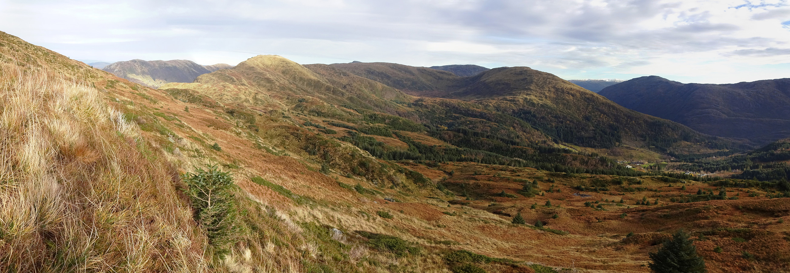
Leaving Bergen southwards along E39, we turned left at Kalandsvatnet to drive road 5162 all the way up to Bontveit. At the highest point of this road (about 300mosl), before it starts winding down to Hausdalen in the south, we parked along with quite a few other cars (the usually quite large parking spot there was "well-used"). While we did see a sign, suggesting the minor road, which extends in northeastern direction from there, as the way to Livarden (which it does, but via Langemyrskaret and Rambjørgvatnet), we followed our original plan to ascent Livarden via Ramslia. To do so, we first followed some minor roads, connecting the farms at the upper end of Bontveit, leading (not considering its many bends) mostly in western direction. While ascending gently (still along this minor road) on the western side of Bontveit, we enjoyed some nice views into the direction of Hausdalshorgi and Sveningen. Before actually getting to Sandgotebekken (and after a rather pronounced turn to the right), the road splits and we took the branch that extend further in northern direction (and upwards). At about 400mosl, we came to another "junction", meeting another forest road that extends "horizontally" across Ramslia (southwest--northeast). More or less exactly at this junction, we then decided to finally leave the road and continue (steeply upwards) across Ramslia (in northwestern direction, basically "direttissima" towards Livarden). With proper hiking boots and some minimal physical preparedness, this ascent is well possible. Roughly 100 height meters higher, one steps out of the forest and onto some intermediate flats south of Revura. This area is pretty wet, but really lovely to visit, including the views towards Slettegga! We then continued our ascent on the other side, still more or less along the direttissima and a bit more than 100 height meters higher, we came to Krokvatnet, a nice little lake only about 50 height meters below the top of Livarden. We then rounded Krokvatnet on its eastern side to continue further up towards Livarden on its northern side. Interestingly, we then "found" a pretty large memorial stone in the very north of Krokvatnet, dedicated to skier and mountain main Johannes Dyngeland. Clearly, those who erected this stone (in 1968) had chosen a particularly lovely place for it (a web page related to orienteering mentions that Johannes Dyngeland apparently liked Krokvatnet and often enjoyed a short break there)! From there, it was then only a few minutes to complete our ascent to Livarden.
Slettegga
On our way up, we had used a trail for the last meters, and found that it was very muddy. We thus decided to descend (into the direction of Slettegga) without a trail, at least first. We thus first walked a bit across the ridge (in northern direction), before then turning eastwards (and downwards) into the direction of Rambjørgvatnet. At about 600mosl, we then joined the trail again, continuing along it downwards until we arrived in the saddle just south of Rambjørgvatnet. Once there, we agreed to include Tverrmeisi (just a bit left of the trail to Slettegga). At Vindhaugane, we thus left the trail and ascended (across a short, steep stretch right north of a rescue box that is installed there, also) to Tverrmeisi (these "in-between" hills are not very high, but offer some nice views into norther direction). After looking down to Haukelandsvatnet and across it to Vidden on the other side, we connected back to the trail and continued our ascent to Slettegga. The ascent to Slettegga is straight forward and well marked (Rett Vest trail), making use of all of the several southward ridges of Slettegga, one after the other. :-) What was interesting, this time, was that some pretty strong winds had come up and, at times, walking straight was not fully trivial! :-) For a moment, we even discussed a possible turn-around (due to the strong winds). We did, however, continue and soon later we had arrived at the top of Slettegga. Walking the short stretch towards "the edge" (Slettegga's northwestern flank is really steep!), we got to enjoy some fantastic views across Haukeland and towards the mountains "on the other side", including Skåldalsfjellet in the north.
Back via Nobbane
Due to the strong winds, we did not stay on Slettegga very long (we just enjoyed one pear each -- a nice treat on top of Slettegga!). Instead, we continued along the trail (the one one the southeastern side of the ridge) in order to get over to Nobbane near the saddle. Staying on the trail, we then crossed over a bit north of the saddle. At about 675mosl (and right at a nice cairn), we turned right (and southwards) at the crossing of two trails (the one which we had taken from Slettegga and the one coming up from Katladalen in the north). While our "new" trail, now leading southwards, indeed was the right one, a short detour in southeastern direction was "necessary" to include the actual "top" of Nobbane (with some nice view over Dyrdalen). From there, then, it was "just" down the ridge, following the trail. At about 460mosl, the trail from Dyrdalen joins (from the left, i.e., from the east). After crossing the waters coming down Storlikråa, the trails leads further down, passing by Bjørnastølen at about 375mosl. Soon after, the trail turns into a forest road, and a little further down, one gets back out to the "main road" right at the parking place.
Photos
Selected photos are available as Google photo album.
Useful Resources
See also the related FB-page Hiking around Bergen, Norway.
Petter Bjørstad has a useful page about Livarden and also web page WestCoastPeaks.com provides useful information about Livarden and Slettegga.
Web page UT.no from the Norwegian Trekking Association recommends a the hike with trail from Bontveit to Livarden.

Kommentarer