Austlendingen (11.10.2020)

| Startsted | Parkering Austlendingen (90moh) |
|---|---|
| Sluttsted | Parkering Austlendingen (90moh) |
| Turtype | Fottur |
| Turlengde | 4t 30min |
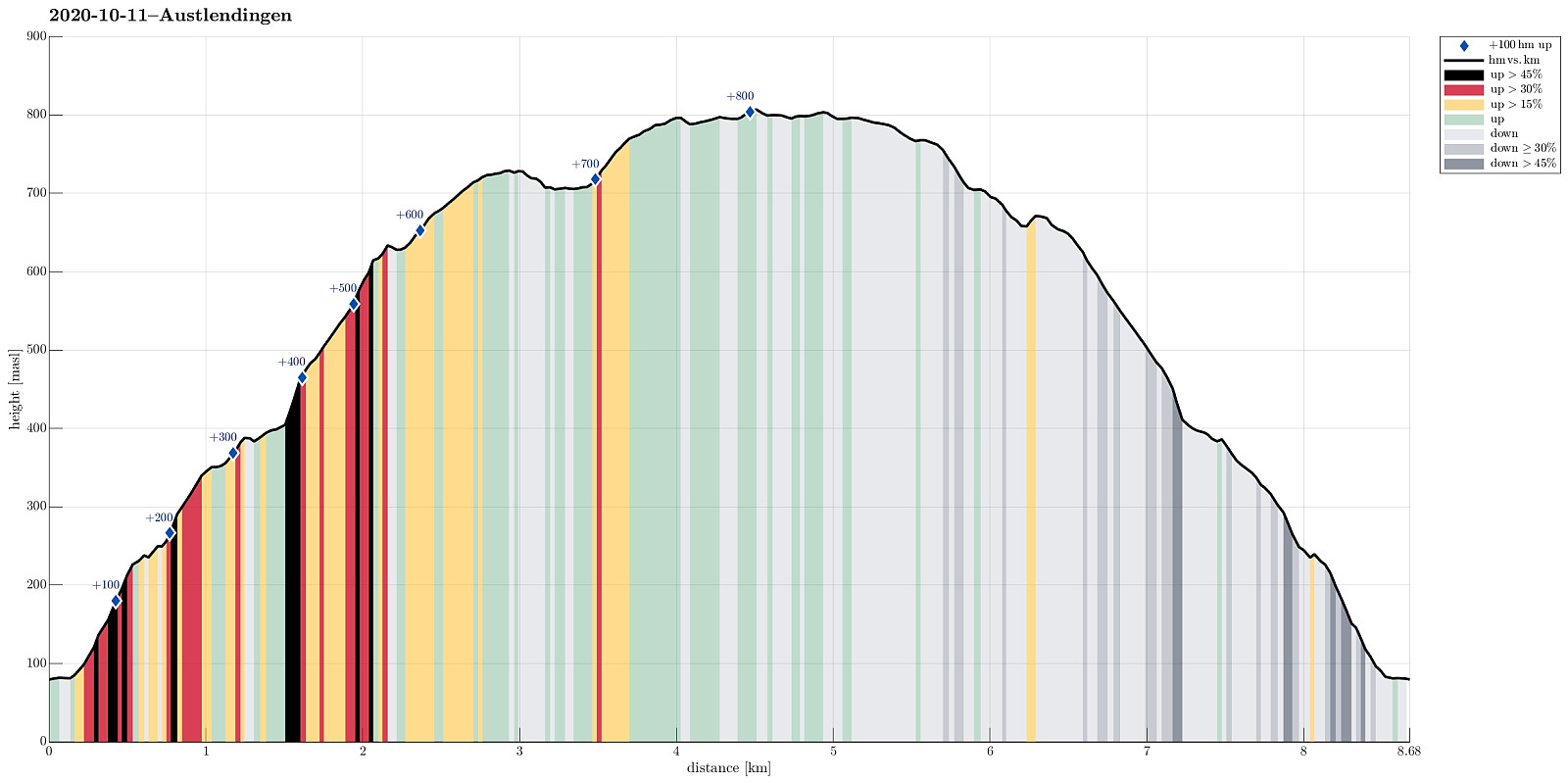
| Distanse | 8,7km |
| Høydemeter | 848m |
| GPS |
|
| Bestigninger | Austlendingen (812moh) | 11.10.2020 |
|---|---|---|
| Nipefjellet (735moh) | 11.10.2020 | |
| Andre besøkte PBE'er | Austlendingen p-plass (90moh) | 11.10.2020 |
Trip Summary
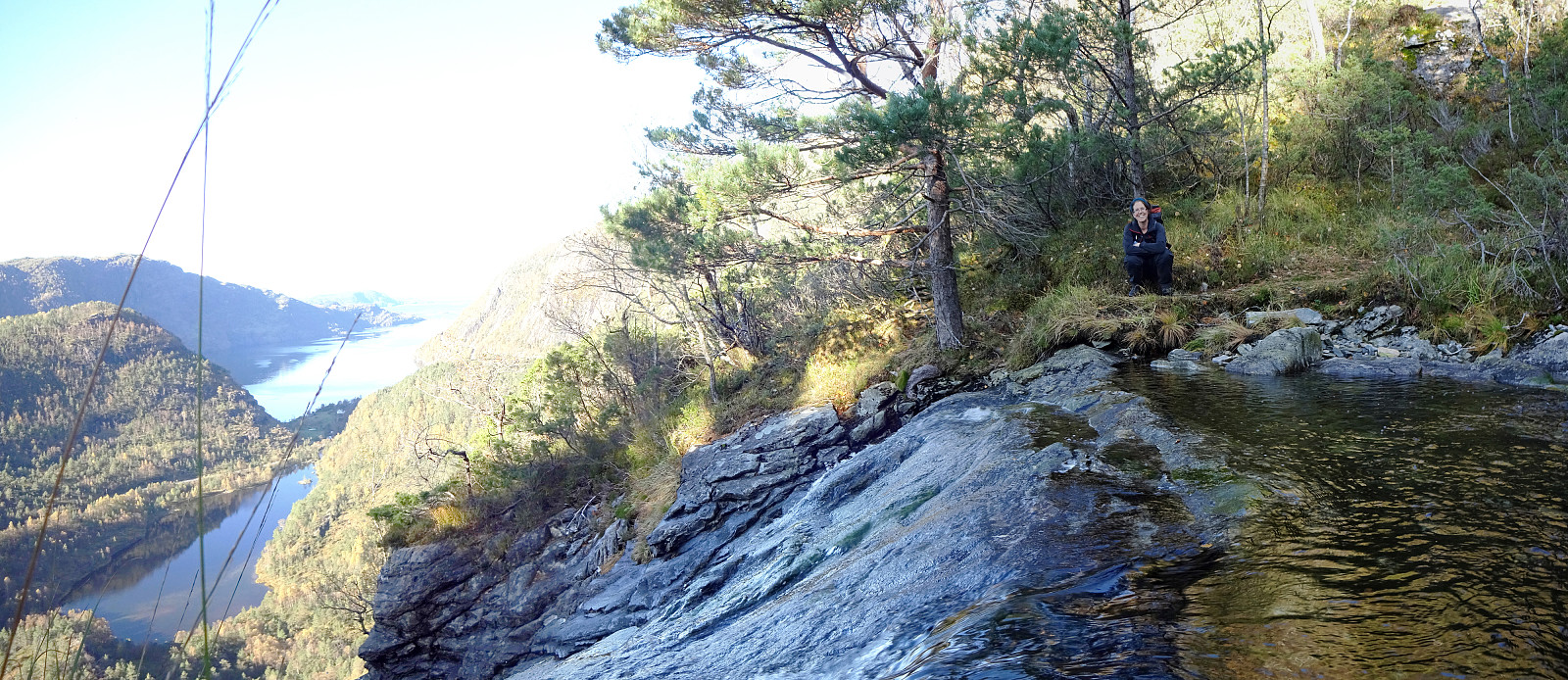
We left Bergen on E39 towards the north (Knarvik) and continued further on E39 in northeastern direction (north of Osterfjorden) after having past Knarvik. Right before we would have entered the long Eikefettunnelen, we turned left (onto road 570) and parked only meters after leaving road E39. Our main goal of the day was Austlendingen and we had thought to start along the main trail there, which starts just meters west of the entry to Eikefettunnelen (on the southern side of road E39). Our plan, as prepared at home, was to attempt a round (off trail up, on the main trail down), but when we came to the trail head, we encoutered a pretty bold sign informing everyone about the ongoing hunting period and that hikers should stay on marked trails. After a little bit of consideration, we decided to cancel the off-trail ascent and instead go (almost) the same route up and down. Following the main trail (easy to find!), we crossed Stegafossen shortly after starting our hike. From there on, the tail stays on the northern side of Stegabotnen, Svartebotnen, and Godbotnen (all the way up, basically). At almost 400mosl, we made the very short extra-ascent to Hujingahogen, enjoying some views into the direction of Austfjorden. We then continued along the main trail until we were in the northwest of Svartebotnen. There, we decided to continue "parallel to the main trail" (in order to get up to Nipefjellet first). While we could have deviated from the main trail a little later, also, and thereby avoid some slightly steeper terrain, we still made it up the southwestern slope of Nipefjellet without any difficulties. This also proided us with additional views into the direction of Austfjorden (which are not so much to enjoy when staying on the main trail). After standing on Nipefjellet for a short moment, we aimed at continuing towards Austlendingen (in northeastern direction). The northeastern side of Nipefjellet, however, is much steeper than its west-facing side, and getting down there -- even though it's only a few meters -- is non-trivial. We thus decided to surround Nipevatnet in its north, instead, heading towards Austlendingen via a ridge in parallel to the main trail (north of it). All this was easy-going and very enjoyable on this beautiful autumn day. A short while later, we arrived at Austlendingen with its rather big cairn. Instead of making a break there, we continued for a short stretch further into northeastern direction until we came to Skavelen, where one starts to get views down (in eastern direction). Finding a very nice spot there, in the shadow of the winds while exposed to the sun, we enjoyed a short break as well as the views. Back we then walked along the main trail, passing Nipefjellet in its east. All in all, this hike was wonderful not at the least because of the excellent autumn weather -- really very nice! :-)
Photos
Selected photos are available as Google photo album.
Useful Resources
See also the related FB-page Hiking around Bergen, Norway.
Petter Bjørstad has a useful page about Austlendingen and also web page WestCoastPeaks.com provides useful information about Austlendingen.
Web page UT.no from the Norwegian Trekking Association recommends basically the same hike.

Kommentarer
Do not "respect" BAD signs!
Skrevet av petter 19.02.2021 21:00In the mountains of Norway, a person doing legal hunting must be careful and avoid ANY potential conflict with hikers. This responsibility rests with the hunter. To use common sense is always smart, but one should not feel that a trail is necessary. You can and should hike wherever you like!!
Re: Do not
Skrevet av HHauser 22.02.2021 09:54Quite obviously, I was "not amused" by that indeed bold sign and thought that it was an infringement. My original plan was to ascend via Kjellrusten (and then go back down along the main trail). Maybe on another day...