Arkiv - dato
Arkiv - aktivitet
-
Annen tur (3)
- Kajakkpadling (3)
- Fottur (1747)
-
Kjøretur (9)
- Biltur (9)
-
Skitur (109)
- Fjellskitur (65)
- Langrennstur (44)
-
Sykkeltur (107)
- Blandet sykling (25)
- Gatesykling (82)
Lister jeg samler etter
-
Utvalgte topper og turmål i Bergen
(332/333)
 99%
99% -
Alle topper i Bergen
(379/386)
98%
-
Kvam ≥ 100m pf.
(41/44)
93%
-
Opptur Hordaland
(143/159)
89%
-
Voss ≥ 100m pf.
(86/98)
87%
-
Stasjoner på Bergensbanen
(28/36)
77%
-
Hordaland ≥ 100m pf.
(593/863)
68%
-
Ulvik ≥ 100m pf.
(26/38)
68%
-
Jondal ≥ 100m pf.
(15/23)
65%
-
Dagsturhyttene i Vestland
(33/61)
54%
-
Sunnhordland PF >= 100m
(100/186)
53%
-
DNT-hytter i Hordaland
(22/45)
48%
-
Hordaland: Hardanger PF>=100m
(170/359)
47%
-
Kvinnherad ≥ 100m pf.
(36/79)
45%
-
Sogndal ≥ 100m pf.
(23/81)
28%
-
DNT-hytter i Sogn og Fjordane
(8/47)
17%
-
Eidfjord ≥ 100m pf.
(6/42)
14%
-
Etne ≥ 100m pf.
(7/51)
13%
-
Ullensvang ≥ 100m pf.
(19/153)
12%
-
Opptur-topper i Sogn og Fjordane
(17/177)
9%

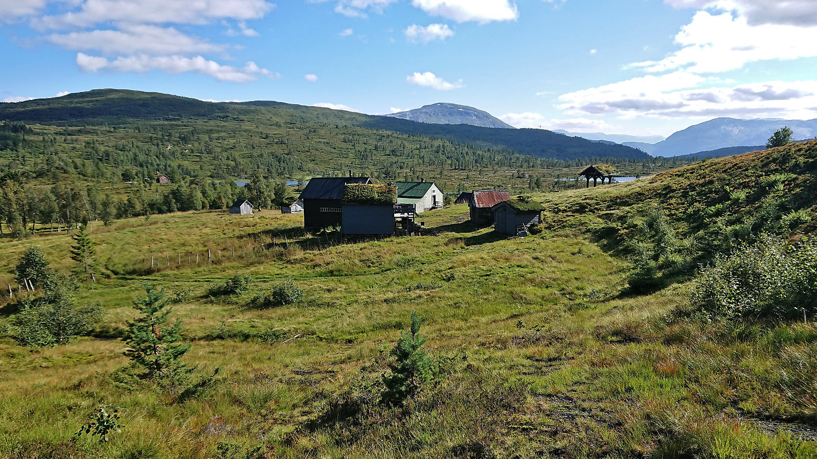
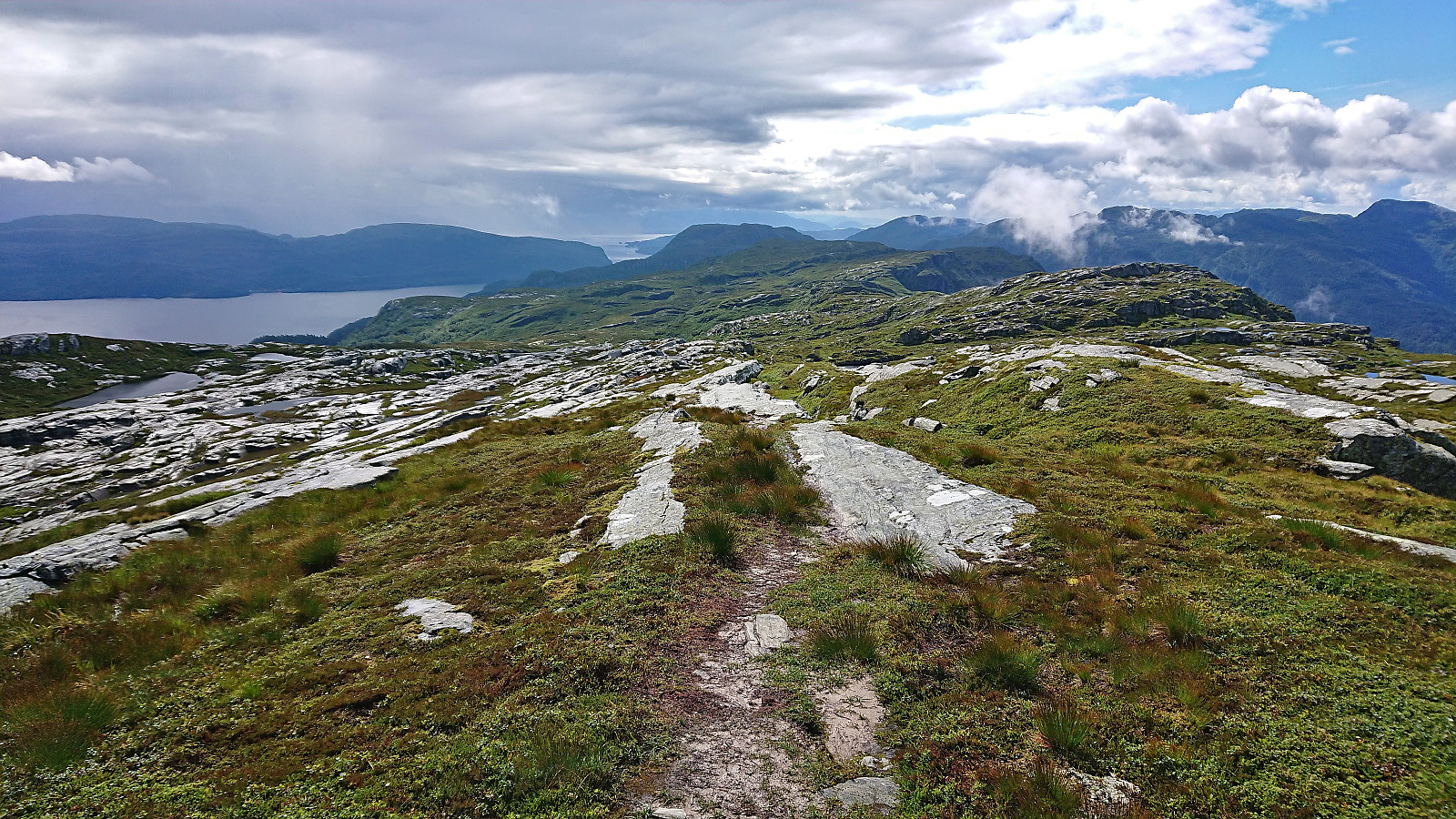
Skorseteggi and Kolingseggi from Oppheimsvatnet to Kløve
- Dato:
- 22.10.2022
- Turtype:
- Fjelltur
- Turlengde:
- 5:10t
- Distanse:
- 19,0km
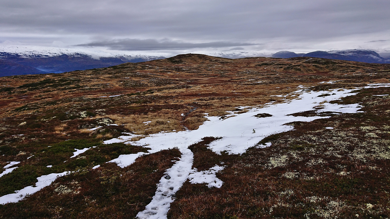 I started by taking the train to Voss with the plan to continue on the bus to Framnes at the western end of Oppheimsvatnet. Due to signaling problems in the tunnel between Bergen and Arna the train ended up arriving 15 minutes late at Voss, but thankfully I still managed to catch the bus heading for Gudvangen. In fact, there were two buses as apparently the tourist season was not quite over.
After getting off the bus at Framnes, I walked back along the main road for about 200 meters (on a broad sidewalk) to cross the bridge to the south side of Oppheimsvatnet where I continued south along Langedalsvegen (the second exit to the right) until locating the marked trailhead for Lemme. The first 100 meters or so consisted of a new tractor road where the earth/mud had not quite set yet, but then changed >>>
I started by taking the train to Voss with the plan to continue on the bus to Framnes at the western end of Oppheimsvatnet. Due to signaling problems in the tunnel between Bergen and Arna the train ended up arriving 15 minutes late at Voss, but thankfully I still managed to catch the bus heading for Gudvangen. In fact, there were two buses as apparently the tourist season was not quite over.
After getting off the bus at Framnes, I walked back along the main road for about 200 meters (on a broad sidewalk) to cross the bridge to the south side of Oppheimsvatnet where I continued south along Langedalsvegen (the second exit to the right) until locating the marked trailhead for Lemme. The first 100 meters or so consisted of a new tractor road where the earth/mud had not quite set yet, but then changed >>>
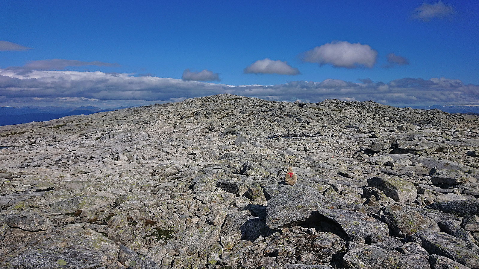
Store and Vetle Finsenuten from Finse 1222
- Dato:
- 30.09.2022
- Turtype:
- Fjelltur
- Turlengde:
- 2:47t
- Distanse:
- 9,9km
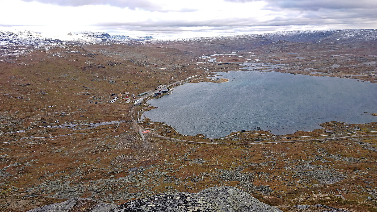 On the way back from a conference in Sundvollen , I stopped at Finse with the plan to go hiking both Friday afternoon and Saturday morning before completing the train ride back to Bergen. Less than 15 minutes after checking in at Finse 1222 I had therefore changed into hiking gear and was on my way to Store Finsenuten . The sun was shining, but a strong cold wind from the southeast made it anything but warm.
After crossing the tunnel covering the railroad tracks, I continued north along a weak trail before heading off-trail up Finseskaret. South of the summit I came across a trail marked with small cairns that I could follow all the way to the large cairn at the highest point of Store Finsenuten. Great views from the summit, but with the strong wind almost making it difficult to stand upright, and the sun now having disappeared behind the clouds, >>>
On the way back from a conference in Sundvollen , I stopped at Finse with the plan to go hiking both Friday afternoon and Saturday morning before completing the train ride back to Bergen. Less than 15 minutes after checking in at Finse 1222 I had therefore changed into hiking gear and was on my way to Store Finsenuten . The sun was shining, but a strong cold wind from the southeast made it anything but warm.
After crossing the tunnel covering the railroad tracks, I continued north along a weak trail before heading off-trail up Finseskaret. South of the summit I came across a trail marked with small cairns that I could follow all the way to the large cairn at the highest point of Store Finsenuten. Great views from the summit, but with the strong wind almost making it difficult to stand upright, and the sun now having disappeared behind the clouds, >>>
Skamdalshorgi, Tinden and Grønahorgi
- Dato:
- 18.09.2022
- Turtype:
- Fjelltur
- Turlengde:
- 8:34t
- Distanse:
- 29,4km
 Ever since I ran out of time three weeks ago , it felt like I had some unfinished business in Granvin. At the first opportunity I therefore once again took the train to Voss and the bus to Bulkokrysset with the plan to finally ascend Skamdalshorgi . My plan almost got off to a bad start though, as the bus from Voss for some reason did not leave the main road for the detour around Tunsbergtunnelen, thus skipping the bus stop at the start of Bulkovegen that I had gotten off at last time. But thankfully I realized this change just in time and managed to get off the bus before it actually went through the tunnel.
With this initial scare out of the way, I walked the short distance to the start of Bulkovegen and proceeded to follow it south to the unmarked trailhead for Skamdalshorgi just north of the summit. (Note that while most of the parking >>>
Ever since I ran out of time three weeks ago , it felt like I had some unfinished business in Granvin. At the first opportunity I therefore once again took the train to Voss and the bus to Bulkokrysset with the plan to finally ascend Skamdalshorgi . My plan almost got off to a bad start though, as the bus from Voss for some reason did not leave the main road for the detour around Tunsbergtunnelen, thus skipping the bus stop at the start of Bulkovegen that I had gotten off at last time. But thankfully I realized this change just in time and managed to get off the bus before it actually went through the tunnel.
With this initial scare out of the way, I walked the short distance to the start of Bulkovegen and proceeded to follow it south to the unmarked trailhead for Skamdalshorgi just north of the summit. (Note that while most of the parking >>>
Såta and Bjørgaknausen from Moseheia
- Dato:
- 04.09.2022
- Turtype:
- Fjelltur
- Turlengde:
- 2:52t
- Distanse:
- 10,2km
 After visiting Borninolten (plus Gråfjellet for Fjellsamleren (Endre Myrdal Olsen) ), we drove the short distance to Moseheia where we parked at an unmarked trailhead after first passing through a gate. Unlike the earlier gate at Skarvastølsvegen, this gate did not say anything about limited access, but the parking lot itself was intended for the cabin owners only. There was however plenty of free spaces and we therefore took the chance to leave the car there for our short hike to Såta .
While the trailhead was unmarked, we would soon come across colored trail markers and the trail was, at least initially, of good quality. The trail forked twice and each time we continued on the option heading up Bergsskaret. But when the trail turned weaker and started descending, we instead simply headed off-trail across Brunane towards Såta.
This required a bit of >>>
After visiting Borninolten (plus Gråfjellet for Fjellsamleren (Endre Myrdal Olsen) ), we drove the short distance to Moseheia where we parked at an unmarked trailhead after first passing through a gate. Unlike the earlier gate at Skarvastølsvegen, this gate did not say anything about limited access, but the parking lot itself was intended for the cabin owners only. There was however plenty of free spaces and we therefore took the chance to leave the car there for our short hike to Såta .
While the trailhead was unmarked, we would soon come across colored trail markers and the trail was, at least initially, of good quality. The trail forked twice and each time we continued on the option heading up Bergsskaret. But when the trail turned weaker and started descending, we instead simply headed off-trail across Brunane towards Såta.
This required a bit of >>>
Høgahorgi, Horganipen and Steinsethorgi
- Dato:
- 27.08.2022
- Turtype:
- Fjelltur
- Turlengde:
- 8:26t
- Distanse:
- 31,3km
 For the third weekend in a row I returned to Voss, but this time on my own and not as part of an organized hike. I started by taking the train to Voss and the bus towards Granvin, getting off at Bulkokrysset. From there I followed the road up to the large parking lot at Madshaugen where I easily located the unmarked trailhead for Høgahorgi . Note that Høgahorgi is also referred to as Nesheimshorgi, where Nesheimshorgi seems to refer to the whole mountain while Høgahorgi to the highest point.
The initial trail quality was very good, but this only lasted until passing the first cabin. After that the trail turned wet and muddy, and I quickly gave up keeping my feet dry. I soon came across another hiker and took the chance to ask for some trail advice, where the most important was to make sure to visit Horganipen for the best >>>
For the third weekend in a row I returned to Voss, but this time on my own and not as part of an organized hike. I started by taking the train to Voss and the bus towards Granvin, getting off at Bulkokrysset. From there I followed the road up to the large parking lot at Madshaugen where I easily located the unmarked trailhead for Høgahorgi . Note that Høgahorgi is also referred to as Nesheimshorgi, where Nesheimshorgi seems to refer to the whole mountain while Høgahorgi to the highest point.
The initial trail quality was very good, but this only lasted until passing the first cabin. After that the trail turned wet and muddy, and I quickly gave up keeping my feet dry. I soon came across another hiker and took the chance to ask for some trail advice, where the most important was to make sure to visit Horganipen for the best >>>
Vossamarsjen 2022 + Hjortahorgi and Skjemmehorgi
- Dato:
- 20.08.2022
- Turtype:
- Fjelltur
- Turlengde:
- 7:09t
- Distanse:
- 29,8km
 Vossamarsjen is a yearly hike organized by the Norwegian Trekking Association , or more specifically Voss Utferdslag , starting from Hodnaberg and following the T-marked trail via Torfinnsheim , Timaglaset , Gråsidetoppen and Roset , before ending up at Gjelle. After last year's success of combining Vossamarsjen with visits of Skorane, Nansenbu and Torfinnshorgi , I decided to have another go, but this time making an even longer detour and instead including a visit of Hjortahorgi .
After getting up very early on the Saturday morning, I took the train to Voss, where I almost missed the last organized bus to Hodnaberg due to the train leaving twenty minutes late from Bergen. The bus arrived at Hodnaberg just after half past nine and I was finally ready to start hiking. I started by following the standard route via the three first check points at Torfinnsheim, Dalsgrovi and Timaglaset, but instead of continuing northeast to the fourth checkpoint at Gråsidetoppen, I turned south along the marked trail to Nansenbu.
Vossamarsjen is a yearly hike organized by the Norwegian Trekking Association , or more specifically Voss Utferdslag , starting from Hodnaberg and following the T-marked trail via Torfinnsheim , Timaglaset , Gråsidetoppen and Roset , before ending up at Gjelle. After last year's success of combining Vossamarsjen with visits of Skorane, Nansenbu and Torfinnshorgi , I decided to have another go, but this time making an even longer detour and instead including a visit of Hjortahorgi .
After getting up very early on the Saturday morning, I took the train to Voss, where I almost missed the last organized bus to Hodnaberg due to the train leaving twenty minutes late from Bergen. The bus arrived at Hodnaberg just after half past nine and I was finally ready to start hiking. I started by following the standard route via the three first check points at Torfinnsheim, Dalsgrovi and Timaglaset, but instead of continuing northeast to the fourth checkpoint at Gråsidetoppen, I turned south along the marked trail to Nansenbu.
Bjørndalshesten and Storebrekkuna from Voladammen to Afdal
- Dato:
- 14.08.2022
- Turtype:
- Fjelltur
- Turlengde:
- 7:41t
- Distanse:
- 24,7km
 This Sunday I joined a hike organized by the Norwegian Trekking Association , more specifically Voss Utferdslag , from Voladammen to Afdal. Or rather I mainly joined the bus transportation at the start and end of the hike, as I had in advance gotten the OK to head off on my own in order to visit a couple of new summits in the area. After getting up very early in the morning, I therefore took the train to Voss where I joined up with the rest of hikers just before 09:00.
The drive up the winding gravel road from Brekkhus to Voladammen was described as an attraction in itself by Voss Utferdslag, which was even more true when done in a large bus with lots of narrow turns and two small tunnels that had to be traversed before reaching the parking lot next to the dam . Here I left the rest of the group and continued northwest on my own looking for the trail to Kvitanosi .
At first I struggled >>>
This Sunday I joined a hike organized by the Norwegian Trekking Association , more specifically Voss Utferdslag , from Voladammen to Afdal. Or rather I mainly joined the bus transportation at the start and end of the hike, as I had in advance gotten the OK to head off on my own in order to visit a couple of new summits in the area. After getting up very early in the morning, I therefore took the train to Voss where I joined up with the rest of hikers just before 09:00.
The drive up the winding gravel road from Brekkhus to Voladammen was described as an attraction in itself by Voss Utferdslag, which was even more true when done in a large bus with lots of narrow turns and two small tunnels that had to be traversed before reaching the parking lot next to the dam . Here I left the rest of the group and continued northwest on my own looking for the trail to Kvitanosi .
At first I struggled >>>
Storåsen/Ljonesåsen from Innstrandavegen
- Dato:
- 05.08.2022
- Turtype:
- Fottur
- Turlengde:
- 1:04t
- Distanse:
- 4,8km
 After visiting Daurmålsegga , I took a short bus ride to Ljones for a quick visit of Storåsen/Ljonesåsen . Previous reports talk about having to bypass a fox fur farm to get to the summit, see for example elbow (Vegard Magnussen) 's report here . The fox farm was however apparently shut down in 2020 and I therefore hoped that I could simply follow the road all the way to the summit, which turned out to be the case. After passing a couple of houses, including green houses, I arrived at the opened gates to the empty fox farm and could simply pass through, out the open gates at the other side, and continue south and then north on the tractor road.
The road split just before reaching the summit from where a smaller road and later trail could be followed south towards the summit. Only a final few meters off-trail was then required to reach the highest point. >>>
After visiting Daurmålsegga , I took a short bus ride to Ljones for a quick visit of Storåsen/Ljonesåsen . Previous reports talk about having to bypass a fox fur farm to get to the summit, see for example elbow (Vegard Magnussen) 's report here . The fox farm was however apparently shut down in 2020 and I therefore hoped that I could simply follow the road all the way to the summit, which turned out to be the case. After passing a couple of houses, including green houses, I arrived at the opened gates to the empty fox farm and could simply pass through, out the open gates at the other side, and continue south and then north on the tractor road.
The road split just before reaching the summit from where a smaller road and later trail could be followed south towards the summit. Only a final few meters off-trail was then required to reach the highest point. >>>
Daurmålsegga from Oma via Raudkleiv
- Dato:
- 05.08.2022
- Turtype:
- Fjelltur
- Turlengde:
- 3:42t
- Distanse:
- 13,2km
 After two unsuccessful attempts at joining a DNT -organized hike across Daurmålsegga from Bolstad to Mundheimsdalen, once cancelled due to bad weather and once COVID restrictions got in the way, I decided to not wait any longer and go ahead on my own. Following the whole ridge would however not be possible and I would instead simply start from Oma and return the same way.
I started by taking the bus to Oma and following the road up to the trailhead at Halvgjenge p-plass , from where I followed the standard marked route via Raudkleiv to the summit of Daurmålsegga. Tractor road almost all the way to Raudkleiv and an easy to follow trail from there all the way to the top, with only a small bit of easy scrambling to reach the summit cairn.
As got to the summit a dense fog had appeared and thus there were next to no views. I decided to wait >>>
After two unsuccessful attempts at joining a DNT -organized hike across Daurmålsegga from Bolstad to Mundheimsdalen, once cancelled due to bad weather and once COVID restrictions got in the way, I decided to not wait any longer and go ahead on my own. Following the whole ridge would however not be possible and I would instead simply start from Oma and return the same way.
I started by taking the bus to Oma and following the road up to the trailhead at Halvgjenge p-plass , from where I followed the standard marked route via Raudkleiv to the summit of Daurmålsegga. Tractor road almost all the way to Raudkleiv and an easy to follow trail from there all the way to the top, with only a small bit of easy scrambling to reach the summit cairn.
As got to the summit a dense fog had appeared and thus there were next to no views. I decided to wait >>>
Sveindalsnuten, Blåkoll, Flatafjellet and Kiellandbu
- Dato:
- 24.06.2022
- Turtype:
- Fjelltur
- Turlengde:
- 6:55t
- Distanse:
- 20,0km
 After spending all of the previous Saturday at work, it was in easy choice to take the following Friday off when the weather forecast for Bergen predicted blue skies and close to 30 degrees. Three other colleagues were quickly convinced to join and we settled on ascending to Kiellandbu from Hodnaberg, with my own goal of also visiting at least a couple of new summits in the area.
We parked next to the power station at Hodnaberg and started by following the gravel road south. After a short steep incline, we left the gravel road and continued on the marked trail to Kiellandbu, enjoying the excellent views along the river. Before reaching Nedre Kvålsdalstjørni, we decided to split into two pairs, given that it was only me and one other colleague that were interested in a slightly longer hike that also >>>
After spending all of the previous Saturday at work, it was in easy choice to take the following Friday off when the weather forecast for Bergen predicted blue skies and close to 30 degrees. Three other colleagues were quickly convinced to join and we settled on ascending to Kiellandbu from Hodnaberg, with my own goal of also visiting at least a couple of new summits in the area.
We parked next to the power station at Hodnaberg and started by following the gravel road south. After a short steep incline, we left the gravel road and continued on the marked trail to Kiellandbu, enjoying the excellent views along the river. Before reaching Nedre Kvålsdalstjørni, we decided to split into two pairs, given that it was only me and one other colleague that were interested in a slightly longer hike that also >>>
