
From Erlendorf to Bovec via Wurzenpaß and Vršič (19.10.2025)

Written by HHauser (Helwig Hauser)

| Start point | Erlendorf (510m) |
|---|---|
| Endpoint | Bovec (460m) |
| Characteristic | Bike trip |
| Duration | 7h 00min |
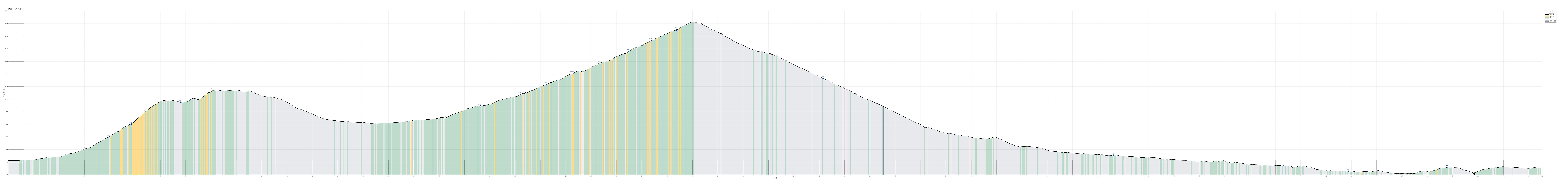
| Distance | 60.5km |
| Vertical meters | 1,983m |
| GPS |
|
| Visits of other PBEs | Austro-Hungarian Military Cemetery (440m) | 19.10.2025 |
|---|---|---|
| Golobar Telpher Line (430m) | 19.10.2025 | |
| Great Soča Gorge (470m) | 19.10.2025 | |
| Prisank view (1,366m) | 19.10.2025 | |
| Supca viewpoint (1,375m) | 19.10.2025 | |
| Tank T-34-85 (1,070m) | 19.10.2025 | |
| Vrsic parking (1,611m) | 19.10.2025 | |
| Wurzenpaß (1,073m) | 19.10.2025 |

Trip Summary
On the first (first real) day of our four-days bike ride through the Julian Alps, we aimed at biking from Erlendorf to Bovec over Wurzenpaß and Vršič. Starting at about 8h30 in the morning in Erlendorf, we headed for the street that leads up to Wurzenpaß immediately. After only about half a kilometer, it became clear that cycling up to Wurzenpaß would be harder than originally anticipated (the rather naive, initial idea was that Wurzenpaß would serve as a quick and not-too-hard warm-up exercise before going for the real pass over Vršič). Even though it was "only" about 500 height meters up from Erlendorf, the challenge was in the slopes, which topped out at about 18% (very steep for cycling indeed)! On Wurzenpaß, we stopped to look at an old tank right next to the road, which reminds visitors of WWII and the time of the cold war. On the southern, Slovenian side of Wurzenpaß, we then cycled down to Podkoren, before continuing to Kranjska Gora on a nice cycling path parallel to the main road. From Kranjska Gora, we then started our second (and longer) ascent, up to Vršič. We first entered the rather beautiful (and also quite tourity!) lower section of river Pišnica, coming by also the Pišnica waterfall. As soon as we had passed by the last houses of Jasna / Kranjska Gora, we entered the Triglav National Park, following the road further up the Pišnica valley (on its western side). Further south, when reaching a height of about 1000masl, the road then ascends into a valley that's in the northwest of Prisank (whereas the main valley extends more towards the northeast of Prisank). From there, it's then still about 600 height meters further up, before one reaches the saddle point at Vršič. It does take some time, but cycling up this mountain road from Kranjska Gora is really nice (even though the area is apparently very popular among tourists, resulting in quite a number of cars -- still, all the traffic was slow and cautious when we were there! :-)). Once on Vršič, we first enjoyed a nice, short break, before then heading further southwards (into the Soča / Isonzo valley). At the Supca viewpoint, we made a short stop, and then we took the main hairpin curves down to the Soča. Next, we passed through Trenta, heading further out the Soča valley. Quite a bit further out the valley, we then stopped to see the Great Soča Gorge, which really is an interesting formation to look at (at this place, the Soča river is carved deeply into the surrounding rocks, forming a really impressive, narrow gorge)! Yet another stretch down the road, we stopped again; this time to inspect what's left of the Golobar Telpher Line (originally built to support one of the many war efforts in this valley; later used to bring down logs from the forest high up the steep slopes next to the Soča river). The last stop before eventually reaching Bovec, the target location of this day's ride, was to visit a large cemetery in the northeast of Bovec, where over 500 soldiers from the Austro-Hungarian army are buried, fallen in the 12th Isonzo battle of WWI. From there, it was then not far to cycle over and into Bovec, where we had a room to stay for two nights.
Photos
Selected photos are available as Google photo album.
Useful Resources
See also the related FB-page Hiking around Bergen, Norway.
See also another page about this four-(five-)days bike trip.


User comments