
Valesåta, Trollevassnibba, Monsvarden, Målefjellet (15.11.2024)

Written by HHauser (Helwig Hauser)

| Start point | Tittelsnesvegen (45m) |
|---|---|
| Endpoint | Tittelsnesvegen (45m) |
| Characteristic | Hike |
| Duration | 4h 00min |
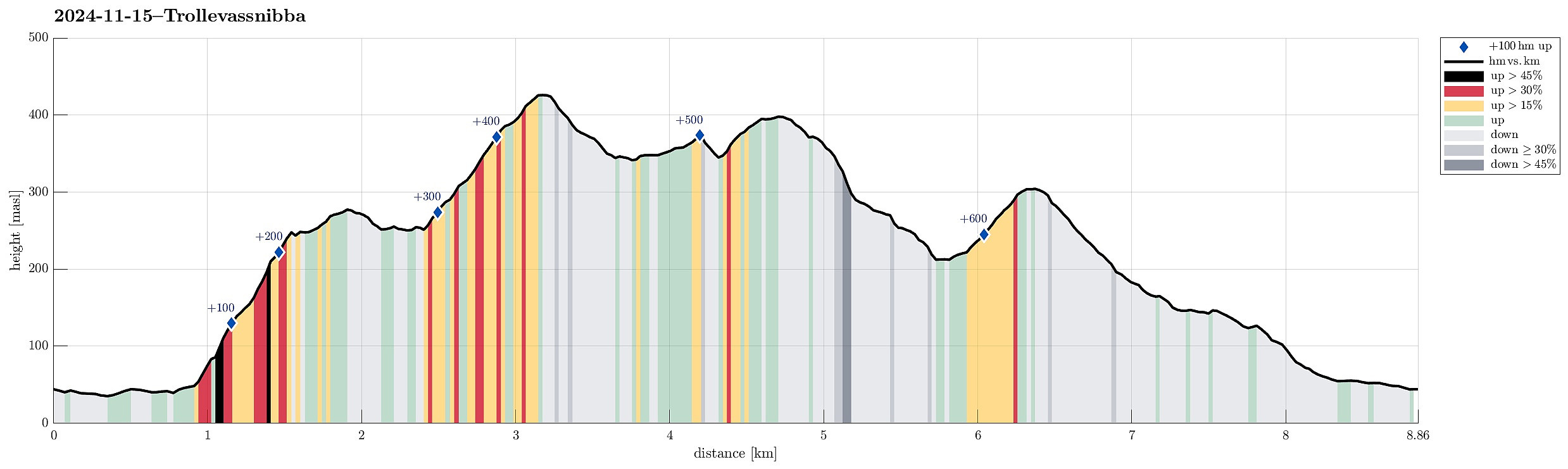
| Distance | 8.9km |
| Vertical meters | 675m |
| GPS |
|
| Ascents | Monsvarden (401m) | 15.11.2024 |
|---|---|---|
| Målefjell (307m) | 15.11.2024 | |
| Trollevassnibba (431m) | 15.11.2024 | |
| Valesåta (280m) | 15.11.2024 |
Trip Summary
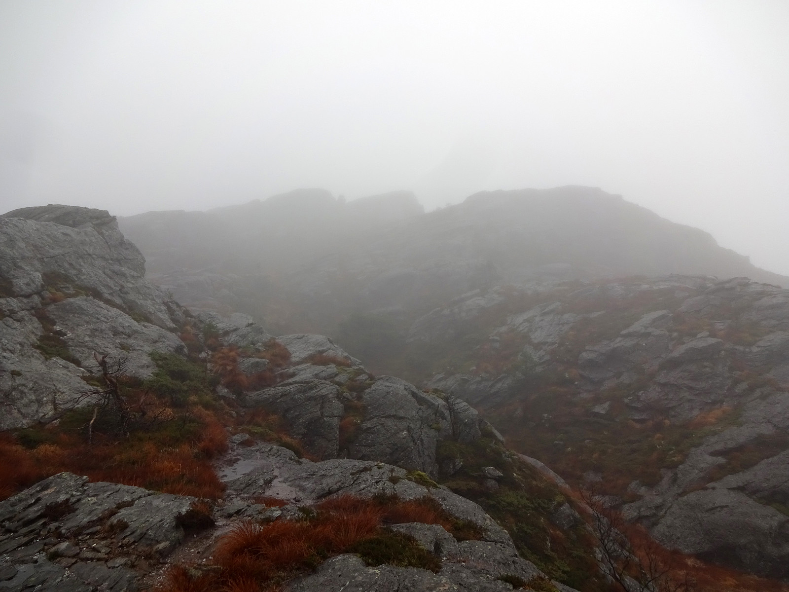
We had left Bergen early on this Friday to still use some daylight time for a hike on Sveio. Right after using the under sea tunnel from Stord, we turned onto Tittelsnesvegen (in a way to head "back" north, but now above the tunnel). Near Valevåg Camping (on the left side of the street) we found a spot to park (on the right side of the street) and started our hike from there. We first continued along Tittelsnesvegen northwards, passing by Valevåg Camping on the left, until we came to the place, where Tittelsnesvegen forks off to the right. Following now this part of Tittelsnesvegen for about two thirds of a kilometer, we got to the trail head on the right of the road. From there, we used a well-marked trail relatively steeply upwards to get up to a ridge in the south of Valesåta. Just a few minutes later, we arrived at the saddle between Valesåta in the northwest and Trollevassnibba in the southeast. On the saddle, one can choose between trails in different directions and we turned left there first to visit Valesåta (really not far from that saddle). On Valesåta we even got to see a bit (down to Valevåg). While we still hoped that Trollevassnibba would offer even more exciting views, it later turned out that our view from Valesåta should remain the best for the day. :-) After returning to the saddle, we then continued into the direction of Trollevassnibba. The trail leads into Trollavassdalen, first. Basically as soon as one gets into this valley, there's another point, where the trail to Trollevassnibba forks off to the left. This leads one across the valley to its eastern side, where one gets onto a nice rock ramp that leads steadily upwards into the direction of Trollevassnibba. This trail is (in principle) easy to follow -- just at the very end, we ended up a bit to much west so that we finished the last meters of the ascent without a trail to the top (not difficult). At Trollevassnibba, we found ourselves within a thick cloud, also with quite a bit of wind -- these circumstances did not invite us to enjoy a long lunch break at the top. Instead, we almost immediately started to discuss our way down again. In principle, we wished to get down in a southward direction, but given the wet and steep terrain without any trail south of the top of Trollevassnibba, we decided to instead "go around". This meant that we first descended in eastern direction (with a trail) until we came into the valley north of Ølestjørna. We then walked southward in this valley, taking the first trail towards the right/west that became visible (not far from Ølestjørna). This trail brought us into another valley in the southwest of Ølestjørna. A bit down this other valley, though, we decided that we actually needed to be significantly further west and thus left the trail (that would lead further down the valley) and ascended upwards and out of the valley towards the west. The terrain was easy to step over there, even though there was no trail. Surrounding the southern-most heights of Trollevassnibba this way (in southwestern direction), we arrived at the eastern-most end of the hills in the south of Trollvatnet. Heading further west (without a trail), we quickly connected to the valley south of Trollvatnet, where also a major power line is. Walking this valley up (in southern direction) brought us to the saddle in the east of Monsvarden. We discussed briefly, whether to continue "straight down" Vassdalen in the south, or to also include a visit to Monsvarden (not that we really expected any views within the clouds, though). We quickly agreed that including also Monsvarden was all too tempting and thus we left the trail at the saddle and found a very reasonable connection to the top of Monsvarden. There, the question then was whether to get back into Vassdalen, or to follow the ridge in the south of Monsvarden. In principle, we thought that making it back down into Vassdalen would be very reasonable (and using the trail there), but when stepping down the ridge southwards from Monsvarden, looking out for a good opportunity to get down in to Vassdalen on our left, it always looked either too steep or a bit too much like a bush war. Since following the ridge was quite doable, instead, we did so. After about 50 height meters dow the ridge, we basically had missed our chance to get down to Vassdalen -- instead, we focussed on getting further down in southward direction. Mostly this worked out fine, only occasionally we had to get through some juniper bushes -- one could say that our attempt to avoid a bush war down into Vassdalen ended up with an off-trail ridge-descent from Monsvarden that nonetheless included a few minor bush battles. Most important, though, was to find a save way down -- especially given the quite steep southwestern side of Monsvarden. With a bit of "left and right" (on both sides of the ridge) we made it down to about 250 masl. About there, we were expecting an opportunity to cross over the ridge and get down into the valley in the southwest (with a stream that comes down from Vassdalstjørna). Somehow, we found a way to do so and down in the valley we then connected with another trail. This trail brought us swiftly to the point, where another trail leads up to Målefjellet (a bit further south). Since we still were in good hiking spirits, we quickly included the ascent to Målefjellet, also. Since we descended from Målefjellet using the same trail, again, we came back to the same point. From there, it was then just to follow a tractor road down to Tittelsnesvegen. Walking back to the parked car along Tittelsnesvegen was then quick and easy. While the weather did not really enable great views, we still enjoyed the hike and getting out into some fresh air. Needless to mention that we did not meet a single other hiker throughout the hike. :-)
Photos
Selected photos are available as Google photo album.
Useful Resources
See also the related FB-page Hiking around Bergen, Norway.
Petter Bjørstad has a useful page about Trollevassnibba and also web page WestCoastPeaks.com provides useful information about Trollvassnibba.
Web page UT.no from the Norwegian Trekking Association recommends a similar hike.


User comments