
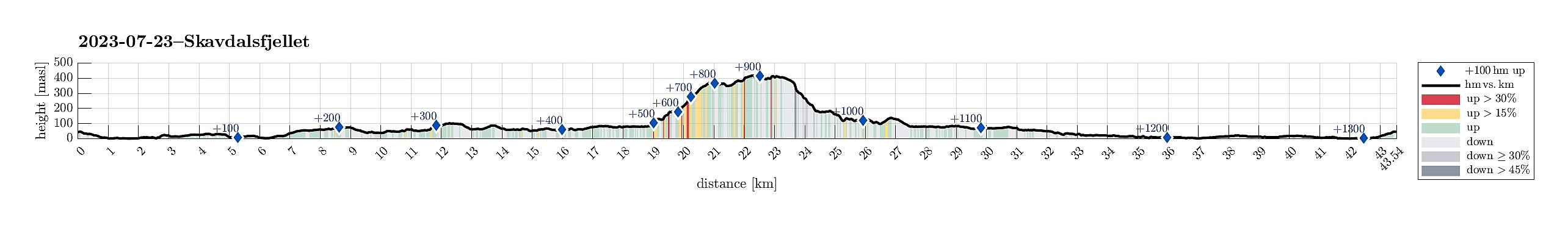
Bike-hiking Skavdalsfjellet (and some additional hills) (23.07.2023)

Written by HHauser (Helwig Hauser)

| Start point | Varden (45m) |
|---|---|
| Endpoint | Varden (45m) |
| Characteristic | Bike trip - mixed |
| Duration | 6h 00min |
| Distance | 43.6km |
| Vertical meters | 1,347m |
| GPS |
|
| Ascents | Barkahaugane (159m) | 23.07.2023 |
|---|---|---|
| Flåfjellet, Bergen (418m) | 23.07.2023 | |
| Kattuglefjellet (134m) | 23.07.2023 | |
| Kattuglehaugane (188m) | 23.07.2023 | |
| Limesbrotet (183m) | 23.07.2023 | |
| Preståsen (129m) | 23.07.2023 | |
| Søre Skavdalsfjellet (420m) | 23.07.2023 | |
| Skjoldhøgda (104m) | 23.07.2023 | |
| Stordalsfjellet (376m) | 23.07.2023 | |
| Storåsen på Skjold (91m) | 23.07.2023 | |
| Visits of other PBEs | Ljoselva foss ved Limesbrotet (125m) | 23.07.2023 |
| Myrdal parkering (80m) | 23.07.2023 | |
| Myrdalshuk (83m) | 23.07.2023 | |
| Skjold søyle (92m) | 23.07.2023 |
Trip Summary
While the hike to and on Skavdalsfjellet was nice, I'd recommend some healthy scepticism/care regarding this brilliant idea to descend via Kattuglehaugane, Barkahaugane, Kattuglefjellet, and Preståsen! Also, it's worth mentioning that these 50+ steep height meters from the uppermost part of the ridge across Barkehushaugane clearly require some special care -- even though all of this is marked as a trail on some maps, it's recommended to first try this route upwards.
Due to some unfortunate illness, this excursion was without the usual company. The idea was to first ride my eBike to a suitable starting point and then do a hike from there. Also, I thought to make a hike, which we quite likely would not do together (parts of the planned hike were predicted to be more like a bush war than anything else*), ending up at the area in the northeast of Myrdalsvatnet with its smaller (and honestly speaking also not terribly exciting) hills (Kattuglehaugane, Barkahaugane, Kattuglefjellet, and Preståsen). I also thought to visit two small hills in Skjold (Skjoldhøgda and Storåsen), since they were along my route to Myrdalsvatnet (and since I thought that I'd never visit them otherwise anyway).
Skjoldhøgda and Storåsen
Biking around Søråsen, I made my way to Skjold. Finding a good route up to Skjoldhøgda was the first small challenge and I had to reroute once to actually make it. What an effort for this hill?! :-) While on Skjoldhøgda, I also stepped up to Skjold søyla (in the north of Skjoldhøgda), just to find this not very pleasant (the area looks more like part of a garden even though there's a narrow stretch that appeared OK to use. Even though the view is quite nice from there, I still returned to my bike quickly. I then visited Skjoldhøgda and I can easily say that this hill is one of the least interesting hills that I ever visited (and I clearly visited many hills by now and I usually come with quite some appreciation for hills in general!). I then found my way to the other side of Apeltunvegen to get up to Storåsen. Following Tranevegen brought me very close and stepping up to this hill was a matter of very few minutes. One could argue for Storåsen to be nicer than Skjoldhøgda, but that doesn't say much. One conclusion, however, is that also this hill will not see me any time soon again. Having done what I had planned at home (Skjoldhøgda and Storåsen), I was ready to my actual hike from Myrdalsvatnet.
Limesbrotet
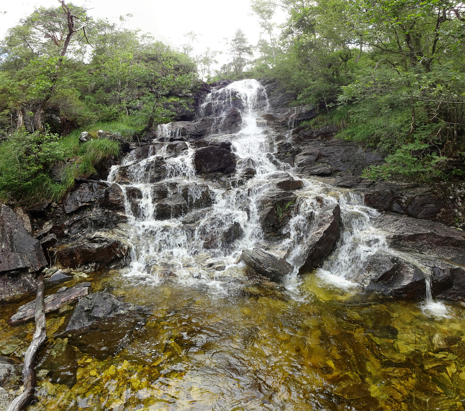
I found a nice way to cycle by Tranevatnet, then underneath E39, followed by a descent down Lilletveitvegen. Soon later I was near Birkelandsvatnet, where I wished to find a connection to Birkelandsbotn in the south of Birkelandsvatnet. While I somehow had overlooked this when studying the map at home, I then easily found a gravel trail. Following this gravel trail, I made it swiftly to Birkelandsbotn (the last few meters up to Birkelandsbotn I had to push my bike, though, so this gravel trail is not 100% for bikes, I'd say). Following then Totlandsvegen for just a short stretch, I arrived at Myrdalsvatnet. Following the gravel road in the southeast of Myrdalsvatnet, I quickly made it to the bridge over Ljoselva, just a few meters from Myrdalshuk. I left my bik behind and started hiking from there, first passing by Myrdalshuk in order to get up to the small hill in the northeast of it (there's a simple trail almost all the way up, so this stretch of this hike as easy-going!). Crossing of this small hill (south to north), I approached a nice waterfall (of Ljoselva) that is in the southeast of Limesbrotet. I took a few pictures and then continued (still on the southeastern side of Ljoselva). Following another simple trail (or so), I quickly made it up to about 150masl (right above the waterfall). There, I had planned to cross over Ljoselva to ascend to Limesbrotet from the east. While I had to manage quite a bit of vegetation on this stretch, ascending to Limesbrotet this way was not really difficult and within a few minutes, I was up there, enjoying some nice views towards the south.
Skavdalsfjellet
While on Limesbrotet, I thought that actually this Sunday was too nice to not include at least one nice mountain, also. I thus decided to aim at Skavdalsfjellet from there. Heading first northeast (parallel to Ljoselva in the southeast) and without a trail, I quickly connected to the main trail towards Furedalen. Once at about 215masl, I then took the trail that leads up to Stordalsfjellet (in northwestern direction). Following this trail up to the top of Stordalsfjellet was then straight-forward and nice! Once on Stordalsfjellet, I developed the idea to make a round around the small lakes on Skavdalsfjellet (in CCW direction). I thus left the trail at Stordalsfjellet and traversed the heights in the east of Stordalsfjellet in order to get "to the other side" (to the east-side of Skavdalsfjellet). This worked out without difficulties and within a short time, I was back on a trail (now on the east-side of Skavdalsfjellet). I followed this trail northwards and ended up on the highest point of Skavdalsfjellet (even though it's not really easy to say, when up there, which of the many hills of Skavdalsfjellet is in fact the highest). There, I started by route back with the next goal being Flåfjellet in the northwest of Skavdalsfjellet. After taking some pictures from Flåfjellet, I wished to get down towards Kattuglehaugane (yes, why there?!). I knew that one could do that via the saddle between Flåfjellet in the north and Stordalsfjellet in the south (and then down Fjellklova and into Skavdalen). I also had seen that the map shows a trail (just on course resolution, though) that leads across Barkehushaugane in the northwest of Skavdalen. The "thing" with this trail is that there are some 50+ height meters (between 315masl and 375masl) that look like overly steep -- both in photos as well as on the map. With all my respect to this steep stretch of this route, I thought to simply check it out and see. I followed the cairns from Flåfjellet (in southwestern direction, north of and high above Fjellklova). At about 375masl, I got close to the steep part, enjoying some very nice views from up there. I did not see any further trail-indications after the last cairn (up on the heights), which added to my suspicion that maybe I would have to return and back up to the saddle in the east of Fjellklova anyway. Meter by meter down the terrain got steeper and soon I had to use my hands to make sure that I'd not get down much faster than what I had planned. Getting closer to a cliff that clearly wouldn't work (not for me, at least), I had to choose, whether to continue further to the south, or further to the northwest. I chose the latter and a few minutes later I got to look down to where I quite likely could continue my excursion in a more regular fashion. Still, I had some 10 or 20 height meters to get down (and the terrain there is clearly not easy). After a bit of climbing, though, I arrived at the upper end of the ridge across Barkehushaugane. Relieved that I did not hurt myself unnecessarily, I continued, finding the trail again! :-) I even passed a sign that could be interpreted that maybe the more southern route would have been easier. All in all, it would have been much smarter to first try this route upwards. After first knowing the ascent, it's then much easier to also descend such a steep section, of course.
Kattuglehaugane, Barkahaugane, Kattuglefjellet, and Preståsen
Following the trail across Barkehushaugane, I quickly got down to about 225masl (where also the power lines crosses over Barkehushaugane). There, instead of continuing further down along the trail, I descended into Skavdalen (this stretch was steep and not 100% easy -- due to vegetation which at times made it hard to see where one would step down to next -- but not really a problem, neither). Still, one probably needs some good reason for leaving the trail for this descent. :-) I then crossed Skavdalen, stepping up to the heights in the northeast of Kattuglehaugane. That's about the place, where the questionable part of this hike really started. :-) Stepping through quite a bit of not always "friendly" vegetation to get to Kattuglehaugane was not really a problem, but clearly not big fun, neither. Stepping down from Kattuglehaugane to Barkahaugane followed this pattern (non-trivial stepping through quite a bit of vegetation, not the most fun). From Barkahaugane, I then had thought to continue to Kattuglefjellet (as if I did not have enough). The southwestern side of Barkahaugane is quite steep, but descending there was still possible (requiring a bit of care, though). Getting up to Kattuglefjellet was then not too difficult. The connection from Kattuglefjellet to Preståsen, however, was likely the least enjoyable, then. Especially before stepping out onto the trail, that comes across a bit northeast of Preståsen, this part of this hike turned out to be a classical bush war (I usually tolerate quite a bit of such a bush war before getting uneasy -- on these meters, in the south of Kattuglefjellet, I really questioned my route seriously). As soon as I was on the trail in the northeast of Preståsen, the continuation was easy. Getting onto Preståsen and back down was then mostly on trail. Unfortunately, there are no views from the top of Preståsen (due to some rather thick forest). Using one of the trail down from Preståsen, I got to the gravel road that makes a rather large loop in the south of Skavdalsfjellet. Choosing the norther part of this loop, I then walked back to my bike along this gravel road. My bike ride back home was then without any further excursion -- my legs signaled that they had done enough for the day. :-)
Photos
Selected photos are available as Google photo album.
Useful Resources
See also the related FB-page Hiking around Bergen, Norway.
Petter Bjørstad has a useful page about Skardalsfjellet and also web page WestCoastPeaks.com provides useful information about Skardalsfjellet.
Web page UT.no from the Norwegian Trekking Association recommends [URL|a similar hike].
Footnote
- Yes, you very well may wonder "Why such a hike?!" -- a 100% reasonable thought! :-)


User comments