Barmaneset on Algrøyna (13.08.2022)

Written by HHauser (Helwig Hauser)

| Start point | Nordre Øyavegen (15m) |
|---|---|
| Endpoint | Nordre Øyavegen (15m) |
| Characteristic | Hike |
| Duration | 3h 00min |
| Distance | 6.8km |
| Vertical meters | 303m |
| GPS |
|
| Visits of other PBEs | Algrøyna parkering (20m) | 13.08.2022 |
|---|---|---|
| Langtrotten (22m) | 13.08.2022 | |
| Trollskogen (15m) | 13.08.2022 |
Trip Summary
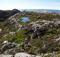
A nice summer day invited us to redo one of our well liked hikes on Algrøyna: to Barmaneset and back. Parking in the east of the little village on Algrøyna, along Nordre Øyavegen, we first followed the street a little further, before turning to the left and onto Kongvikvegen. Once passed Jonsokhaugen, we left the road, rounding a farm house on the way down to the innermost end of Kungvika. There, we "crossed over" to the southern side in order to end up on Barmaneset, not on Smalaneset, north of Barmaneset. Walking out to Barmaneset is then easy, following a proper trail. Once at the western end of the trail, we continued a bit further out towards Langtrotten, which always impresses with its wild nature. On the way back, we then followed "the other trail", a little further south, in order to surround Storavatnet in its south. After enjoying a nice break at Storavatnet, we briefly explored Trollskogen in the east of the lake, before walking back to where we had started. All in all, Algrøyna is really a very nice island for not too long hikes, offering both lovely and wild impressions from nearby the North Altantic.
Photos
Selected photos are available as Google photo album.
Useful Resources
See also the related FB-page Hiking around Bergen, Norway.
Web page UT.no from the Norwegian Trekking Association recommends a similar hike.


User comments