
Wet Litlesotra (very wet!) (25.03.2017)

Written by HHauser (Helwig Hauser)

| Start point | Vågo (5m) |
|---|---|
| Endpoint | Vågo (5m) |
| Characteristic | Hillwalk |
| Duration | 3h 00min |
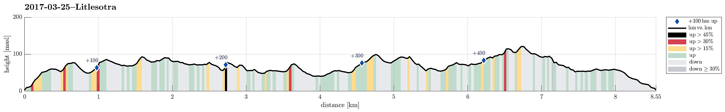
| Distance | 8.5km |
| Vertical meters | 491m |
| GPS |
|
| Ascents | Botlanipene SØ (123m) | 25.03.2017 |
|---|---|---|
| Botlenipa (124m) | 25.03.2017 | |
| Burdalsfjellet (102m) | 25.03.2017 | |
| Storanipa, Litlesotra (81m) | 25.03.2017 | |
| Ørnareiret, Litlesotra (89m) | 25.03.2017 |
Trip Summary
I took the car along road #555 towards the west from Bergen, crossing the Sotra-bridge to Litlesotra. There, I continued to Straume (where also the Sator Center is), and followed the small road #209 towards the north from there. I passed the places, where one could drive to Foldnes and to Anglavik, later, and arrived in a small place called Vågo shortly after.
Stornipa and Ørnareiret
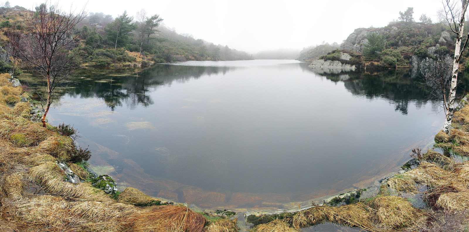
I left the car in Vågo and started my hike in southern direction. Very soon, I had to leave the path, which I had started on, and continued through the wild (as expected from studying the map in advance). The first (nearby) target was Storanipa, just south of Vågo. On its western side, there are steep cliffs, but ascending to it from any of the other directions is straight forward. Next, I had already planned to cross over (in south-eastern direction) to Ørnareiret. Also this (small) top has a very steep cliff-side in the west. Accordingly, it was not so clear, how to really get up there (even though the top is only 90mosl high!). After a bit of checking, I managed to climb up, but it was not 100% easy (in particular, also, given the very wet conditions). From up there, I continued in south-eastern direction, coming down to a small lake (without a name?). I passed this small lake on its western side, before continuing further in south-eastern direction.
Extra-loop to Knarvik
A little east of Steinsfjellet, I connected to a gravel road, which connects Foldnes Kyrkje (in the south-west) with Hjelteryggegn (in the north-est). I walked a little bit along this gravel road (in eastern direction) until I found the place, where a path leaves to the south. I followed this path, surrounding Lyklavatnet on its southwestern side, and continuing in south-eastern direction until I came to Skjendalen. There, I first walked a bit to the east until I came close to the street (to Hjelteryggen). I then turned around and decided to walk around Storavatnet (south of if). Walking along Storavatnet on its eastern side was OK until I came close to the main road (#555). I managed to get down to the road, but couldn't see, then, how to get past the buildings there in order to continue along Storavatnet. I first tried to do so by crossing under road #555 and walking a bit westwards on its southern side, but didn't really see, then, how to get back to its northern side (and Storavatnet). After walking back, I then found a way (between the houses), which brought me back on a simple path that continued along Storavatnet. This path then brought me to the dam, which holds back Storavatnet on its southwestern side. Crossing the dam, I found myself on an easy-to-find path up to Burdalsfjellet and from there further northwards. Instead of simply staying on the path, I included a small top between the path and the gravel road. First, I thought that it maybe would be possible to connect directly to the gravel road, but then I found the terrain to steep to continue. Thus, I got back on the path over Burdalsfjellet and followed it further, crossing over the dam, holding back Odavatnet / Magnusvatnet. This brought me back to the path, which I had taken to Skjendalen, and I followed it back to the gravel road.
Botlanipene
Once on the gravel road, I followed it until I got close to the first houses of Hjelteryggen. There, I turned left and started to head northwards (kind of "in parallel to Hjelteryggen"). I found a way to ascend to Botlanipene (not high neither), before I decided that it was time to get back to the car. I managed to get down from Botlanipene on the northwestern side (a bit steep, but OK), before turning left and westwards. I descended a bit, but then understood that another cliff (above Langavatnet) was making a further descent impossible. Instead, I followed a narrow step along the hill (in northwestern direction). After having rounded the hill (on my right), I found a narrow gully, which led downwards. This way, I ended up in the northern end of Langavatnet. I followed the water, which runs down from Langavatnet to Kvernavatnet, und found a simple path after a while (in Goddalen). This path led me past Kvernavatnet (on its southern side) and further into the direction of Vågo. Not long after, I was back to the car.
Conclusion
Hiking Litlesotra is kind of strange. On the one hand, there is this somewhat extended area with (almost) untouched nature. Traversing this area, even without paths, is possible, but not completely easy (even though there are no high mountains whatsoever on Litlesotra, you still come to steep cliffs that require creative solutions). On the other hand, it is clear that comparably many people are at least nearby (I met several other, walking their dogs along the gravel road, for example). And then, this hike was so very wet. Throughout the 3h "in the wild" it was basically raining all the time. Not only that this hike was basically walking in water, also everything else ended up completely soaked. Also an experience! :-)
Photos
Selected photos are available as Google photo album.
Useful Resources
See also the related FB-page Hiking around Bergen, Norway.


User comments