Archive - Date
Archive - Activity
- Bike trip (2)
-
Climbing (8)
- Alpine climbing (7)
- Mixed climbing (1)
-
Other trip (1)
- Expedition (1)
-
Other winter trip (10)
- Snowshoe trip (10)
-
Ski trip (49)
- Randonnée/Telemark (49)
-
Trip by foot (228)
- Alpine trip (57)
- Hike (69)
- Hillwalk (89)
- Jogging (11)


Collected lists
-
Romsdal ≥ 100m pf.
(134/301)
 44%
44% -
Sunnmøre ≥ 100m pf.
(78/531)
14%
-
Norges 1000 største fjell målt i primærfaktor
(52/1000)
5%

Nasjonaldagstur til Straumshornet i Sykkylven
- Date:
- 17.05.2026
- Characteristic:
- Hillwalk
- Duration:
- 4:48h
- Distance:
- 8.1km
Rundtur fra Jordalsvatnet
- Date:
- 03.05.2026
- Characteristic:
- Hike
- Duration:
- 4:34h
- Distance:
- 13.4km
På løpetur med Dag i byfjellene i Bergen
- Date:
- 01.05.2026
- Characteristic:
- Jogging
- Duration:
- 3:58h
- Distance:
- 23.0km
Fjelltur til Frænavarden med Sol
- Date:
- 18.10.2025
- Characteristic:
- Hillwalk
- Duration:
- 4:32h
- Distance:
- 13.7km
 Min eldste datter flyttet til Molde for noen år siden, og det har gitt meg muligheten til å bli litt kjent med Moldemarka og Moldefjellene, når jeg er i Molde og besøker henne. Denne lørdagen bestemte vi oss for å gå opp til Frænavarden [589 m.o.h.], og la i vei innover i Moldemarka. Vi kunne saktens ha kjørt ut til Fjellbrudammen Parkering, og fått en litt kortere vei inn til Frænavarden, men min datter bor ganske tett inntil Moldemarka noe lengre inne (i Nordbyen), så vi valgte å gå derfra.
Vi fulgte en fin grusvei (bilde #1) innover i marka omkring 2 og en halv kilometer, og kom så til skiltet på bilde #2. Her tok vi til venstre, og fulgte en sti som gikk gjennom litt myrlendt terreng de første ca. 100 meter, men som så førte opp på nordøstryggen av Moldeheia, hvor det >>>
Min eldste datter flyttet til Molde for noen år siden, og det har gitt meg muligheten til å bli litt kjent med Moldemarka og Moldefjellene, når jeg er i Molde og besøker henne. Denne lørdagen bestemte vi oss for å gå opp til Frænavarden [589 m.o.h.], og la i vei innover i Moldemarka. Vi kunne saktens ha kjørt ut til Fjellbrudammen Parkering, og fått en litt kortere vei inn til Frænavarden, men min datter bor ganske tett inntil Moldemarka noe lengre inne (i Nordbyen), så vi valgte å gå derfra.
Vi fulgte en fin grusvei (bilde #1) innover i marka omkring 2 og en halv kilometer, og kom så til skiltet på bilde #2. Her tok vi til venstre, og fulgte en sti som gikk gjennom litt myrlendt terreng de første ca. 100 meter, men som så førte opp på nordøstryggen av Moldeheia, hvor det >>>
Tur til Moldurfjellet i Ytre Sogn
- Date:
- 14.10.2025
- Characteristic:
- Hillwalk
- Duration:
- 3:22h
- Distance:
- 9.6km
 Vi var på tur fra Bergen til Ålesund, jeg og eldste sønnen, og hadde bestemt oss for å stoppe, og ta oss en fjelltur underveis. Været var ikke det beste, og det var synd, for vi hadde plukket oss ut et fjell som ved fine værforhold ville gitt fin utsikt utover Sognefjorden, nemlig Moldurfjellet [844 m.o.h.], ikke så langt fra Høyanger i Ytre Sogn. Etter å ha tatt ferja over fra Oppedal til Lavik, fortsatte vi til Vadheim, for så å ta av og kjøre ut Vadheimsfjorden igjen på motsatte side, og så innover langs Sognefjorden til vi kom til Kyrkjebø. Der forlot vi fylkesveien, og kjørte gjennom et byggefelt, og opp til Helleveien, hvor det var anlagt en brukbart stor parkeringsplass (bilde #1), akkurat der en grusvei oppover i skogen starter.
Skogsveien (bilde #3) tok oss bare ca. >>>
Vi var på tur fra Bergen til Ålesund, jeg og eldste sønnen, og hadde bestemt oss for å stoppe, og ta oss en fjelltur underveis. Været var ikke det beste, og det var synd, for vi hadde plukket oss ut et fjell som ved fine værforhold ville gitt fin utsikt utover Sognefjorden, nemlig Moldurfjellet [844 m.o.h.], ikke så langt fra Høyanger i Ytre Sogn. Etter å ha tatt ferja over fra Oppedal til Lavik, fortsatte vi til Vadheim, for så å ta av og kjøre ut Vadheimsfjorden igjen på motsatte side, og så innover langs Sognefjorden til vi kom til Kyrkjebø. Der forlot vi fylkesveien, og kjørte gjennom et byggefelt, og opp til Helleveien, hvor det var anlagt en brukbart stor parkeringsplass (bilde #1), akkurat der en grusvei oppover i skogen starter.
Skogsveien (bilde #3) tok oss bare ca. >>>
Fjelltur til Eggenibba med Dag
- Date:
- 12.10.2025
- Characteristic:
- Hillwalk
- Duration:
- 3:05h
- Distance:
- 5.0km
 Min sønn og jeg hadde hvert vår ærend i Bergen, men valgte å kjøre sammen sørover; og planla da å ta én fjelltur underveis på vei til Bergen, og én på vei hjem igjen noen dager senere. Jeg har mange ganger kjørt gjennom Våtedalen mellom Byrkjelo og Skei når jeg har vært på vei mellom Nordfjord og Sunnfjord, og har da lagt merke til Eggjenibba, et fjell som fra avstand ser ut til å reise seg midt i dalføret; selv om det rent definisjonsmessig selvsagt er én dal på hver side av fjellet (Våtedalen på vestsida av fjellet, og Øvredalen på østsida).
For ikke å bruke for lang tid på turen (vi skulle tross alt helt til Bergen denne dagen), kjørte vi like opp i Øvredalen, og parkerte på Høgredalsvegen parkering, som ligger 542 m.o.h. Har man bedre tid på seg, er det også >>>
Min sønn og jeg hadde hvert vår ærend i Bergen, men valgte å kjøre sammen sørover; og planla da å ta én fjelltur underveis på vei til Bergen, og én på vei hjem igjen noen dager senere. Jeg har mange ganger kjørt gjennom Våtedalen mellom Byrkjelo og Skei når jeg har vært på vei mellom Nordfjord og Sunnfjord, og har da lagt merke til Eggjenibba, et fjell som fra avstand ser ut til å reise seg midt i dalføret; selv om det rent definisjonsmessig selvsagt er én dal på hver side av fjellet (Våtedalen på vestsida av fjellet, og Øvredalen på østsida).
For ikke å bruke for lang tid på turen (vi skulle tross alt helt til Bergen denne dagen), kjørte vi like opp i Øvredalen, og parkerte på Høgredalsvegen parkering, som ligger 542 m.o.h. Har man bedre tid på seg, er det også >>>
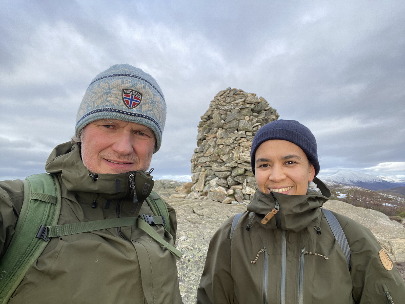
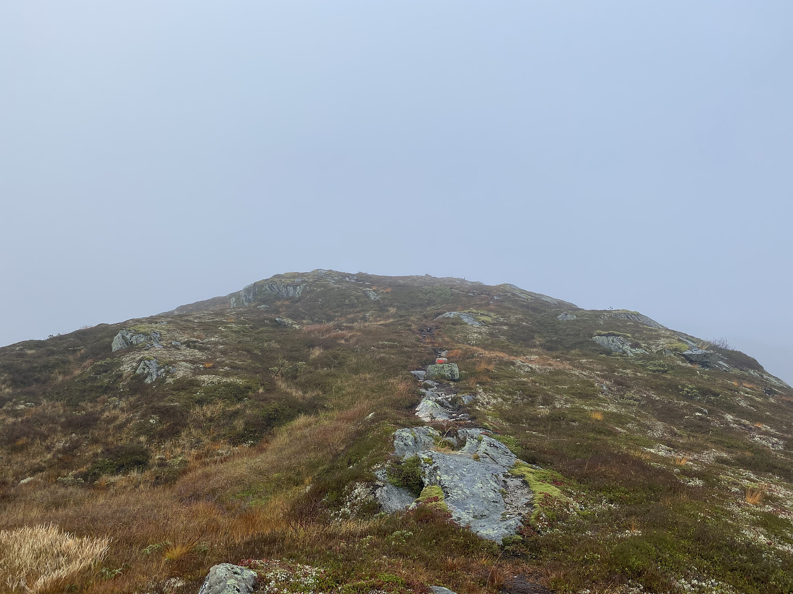
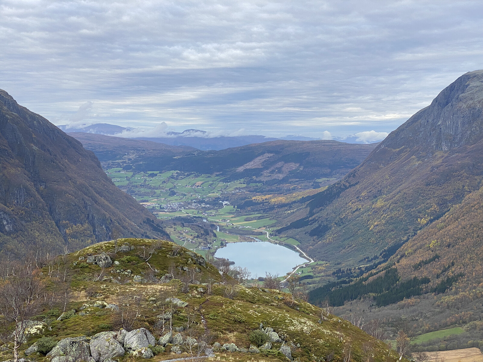
Til Liafjellet med Sol
- Date:
- 04.10.2025
- Characteristic:
- Hillwalk
- Duration:
- 2:57h
- Distance:
- 9.0km
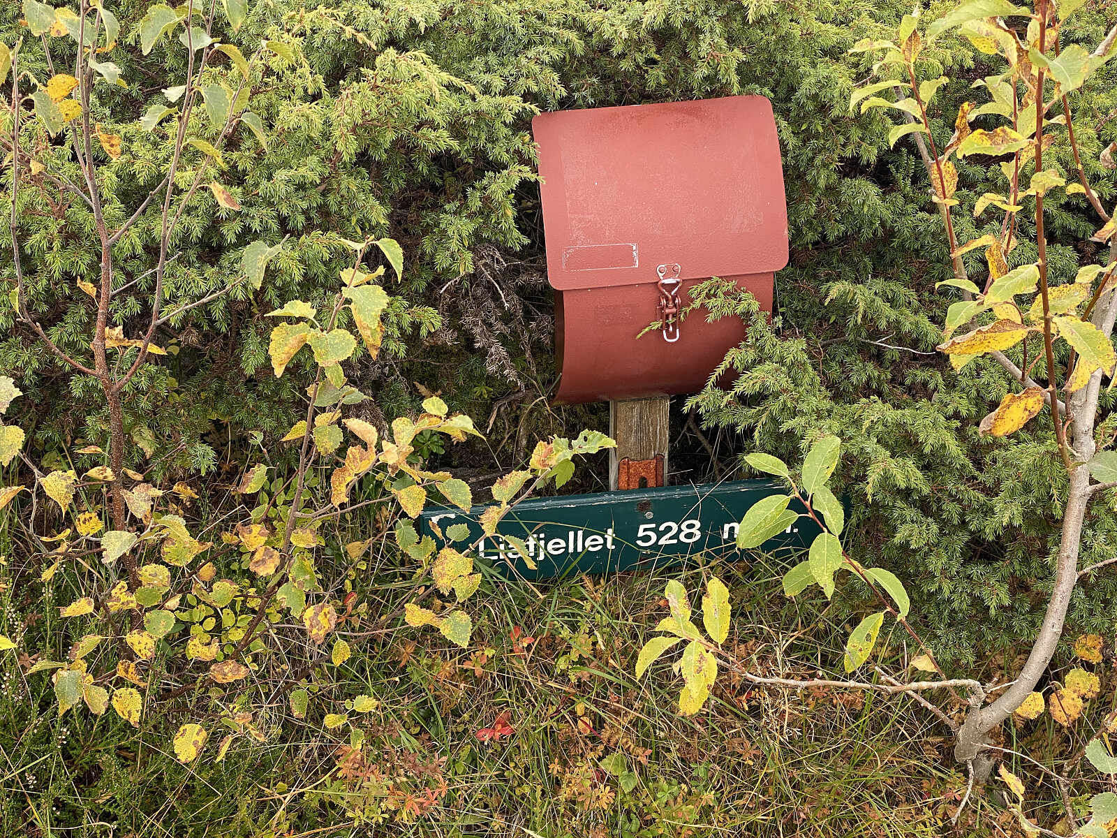 Denne dagen var det jeg og eldste datter som dro på tur sammen. Jeg hadde ikke vært på Liafjellet før, men eldste-sønnen, Dag, hadde fortalt at det var en fin og ikke så lang tur, og han hadde også nevnt at det gikk an å parkere på gamle-veien nedenfor Tøssesvingen, og stort sett følge Liafjellets vestrygg opp til topps. Det nevnte stedet der man kan parkere, er ikke synlig fra riksveien. Da riksveien ble utbedret tidlig på 2000-tallet, ble det anlagt en helt ny sving ca. 30 meter innenfor, og 8 høydemeter ovenfor den gamle Tøssesvingen, slik at veien ikke bare ble utbedret, men svingen også rettet ut en del. Den gamle veien ble imidlertid ikke fjernet, og hvis man tar til høyre like etter svingen (når man kommer kjørende i retning Sjøholt), så er det ikke så vanskelig >>>
