Archive - Date
Archive - Activity
-
Bike trip (137)
- Bike trip - mixed (51)
- Bike trip - road (9)
-
Other trip (1)
- Kayaking (1)
-
Other winter trip (4)
- Snowshoe trip (4)
- Ski trip (4)
- Trip by foot (740)
Archive - Geography
Peakbook-Friends


Collected lists
-
Bergen ≥ 50m pf. og ≥ 100 m.o.h.
(87/89)
 97%
97% -
Most dominating tops of the Bergen peninsula
(68/75)
90%
-
Utvalgte topper og turmål i Bergen
(316/350)
90%
-
Alle topper i Bergen
(357/398)
89%
-
Opptur Bergen
(100/113)
88%
-
De syv fjell rundt Bergen
(6/7)
85%
-
Sund ≥ 50m pf.
(14/18)
77%
-
Os ≥ 50m pf.
(25/34)
73%
-
Søyler (fastmerker) i Bergen
(68/100)
68%
-
Fjell ≥ 50m pf.
(21/32)
65%

Round around Dyrdalsvatnet from Øvstebø
- Date:
- 15.10.2022
- Characteristic:
- Hike
- Duration:
- 4:30h
- Distance:
- 10.1km
 We expected a rather nice autumn day and decided to hike up to Hausdalshorgi, one of our favorite mountains near Bergen. A good way to approach Hausdalshorgi is from Øvstebø, a short way further northeast from Bontveit. The usual route leads first up to Dyrdalsvatnet (parallel to Dyrdalselva, on its northwestern side) and from there further up to Hausdalshorgi, conveniently using a little bridge over Dyrdalselva (when it's not swept away by some floods as a few years back). This time, we wished to explore an alternative approach to Hausdalshorgi, crossing Dyrdalselva already at Øvstebø, then ascending through the forest up to Bjørnaberget, and then further up along a small ridge that extends in northwestern direction from Bjørnaberget. Even though the stretch up to Bjørnaberget is >>>
Lyderhorn from Loddefjord
- Date:
- 11.09.2022
- Characteristic:
- Hike
- Duration:
- 1:30h
- Distance:
- 4.2km
 With only limited time available, we decided to "just" make a short hike to Lyderhorn, exploring a new "corner" of this rather well-known mountain. We started biking to Loddefjord. We then continued up a side road of Lyderhornsveien, which services the power facility a few meters above Loddefjord, right below Skarpafjellet. From there, we first followed the trail that leads up to Grøvledalen, but decided to follow a slightly different route up, first. Soon later, we reconnected with the trail between Skarpafjellet and Lyderhorn. From there, it was then basically up and down Lyderhorn, mostly following trails. On the way back, we then descended towards Loddefjord through Grøvledalen. Nice to explore new routes, even on an often visited mountain like Lyderhorn! :-)
Gaustadfjellet, Litlafjellet, Bårafjellet, Øyjordsfjellet
- Date:
- 04.09.2022
- Characteristic:
- Hike
- Duration:
- 6:30h
- Distance:
- 11.4km
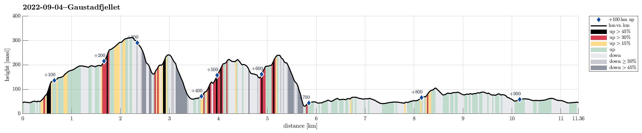 Looking forward to a nice day, we decided to pay Gaustadfjellet on Holsnøy a visit. To get there, we crossed Krossnessundet right after driving over Nordhordlandsbrua, north of Bergen. Then, we followed road 5310 northwestwards, kind of parallel to Radfjorden on our right side. Since we wished to start our hike from the southeast, traversing all of Gaustadfjellet (and further), we first needed to find a proper parking place along Ådlandsvegen. After a bit of back and forth, we managed to park properly along this rather narrow road. We then followed a not really well visible trail to the southern ridge of Gaustadfjellet (Storhøyden). From there, then, we could use a nice trail that extends over most of this ridge. It's actually a very nice alternative to the otherwise shorter ascent >>>
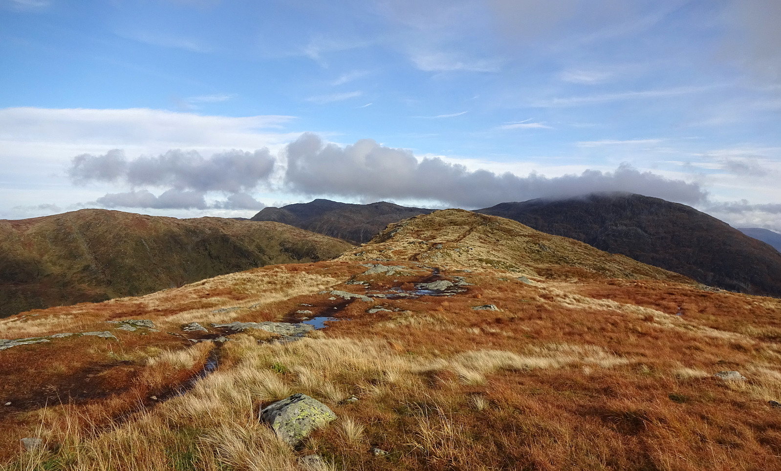
Lyshornet from Lysekloster
- Date:
- 03.09.2022
- Characteristic:
- Hike
- Duration:
- 2:30h
- Distance:
- 7.3km
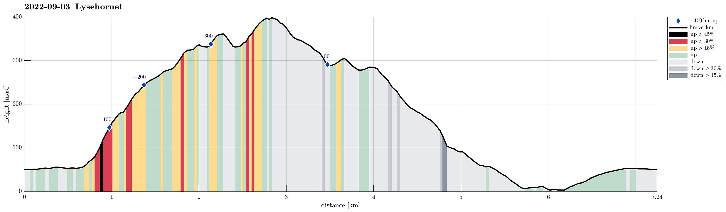 To get some fresh air, we decided to do a simple hike, not far from home: Lyshornet. We parked near Lysekloster and followed the main trail to Lyshornet from there. This lead us up to Lyshornskaret from where a short detour to Vetla Lyshornet was included. After enjoying the day for a moment on Lyshornet, we then started our hike down, following a trail towards the west from the top. This trail leads one down to the service road, which leads up to Ulvvatnet from Lyseklostervegen. Once on this road, it was then to first walk it down, before then following Lyseklostervegen back up to where we had parked. Clearly a nice little round with some nice views from Lyshornet.
Selected photos are available as Google photo album .
See also the related FB-page Hiking around Bergen, Norway .
Petter Bjørstad has a useful page about Lysehornet and also web page WestCoastPeaks.com provides useful information about Lysehornet .
Web page UT.no from the >>>
To get some fresh air, we decided to do a simple hike, not far from home: Lyshornet. We parked near Lysekloster and followed the main trail to Lyshornet from there. This lead us up to Lyshornskaret from where a short detour to Vetla Lyshornet was included. After enjoying the day for a moment on Lyshornet, we then started our hike down, following a trail towards the west from the top. This trail leads one down to the service road, which leads up to Ulvvatnet from Lyseklostervegen. Once on this road, it was then to first walk it down, before then following Lyseklostervegen back up to where we had parked. Clearly a nice little round with some nice views from Lyshornet.
Selected photos are available as Google photo album .
See also the related FB-page Hiking around Bergen, Norway .
Petter Bjørstad has a useful page about Lysehornet and also web page WestCoastPeaks.com provides useful information about Lysehornet .
Web page UT.no from the >>>
Barmaneset on Algrøyna
- Date:
- 13.08.2022
- Characteristic:
- Hike
- Duration:
- 3:00h
- Distance:
- 6.8km
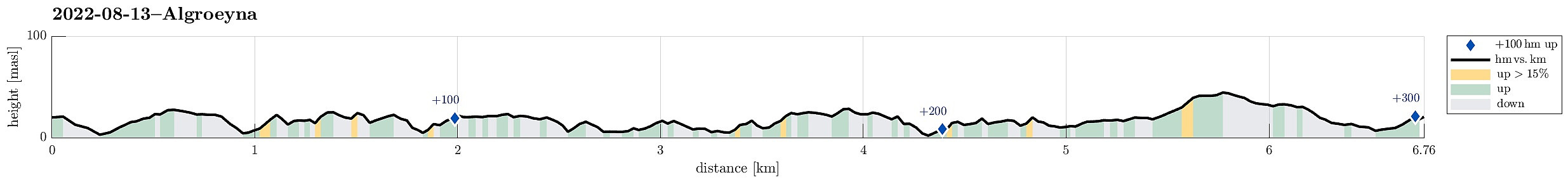 A nice summer day invited us to redo one of our well liked hikes on Algrøyna: to Barmaneset and back. Parking in the east of the little village on Algrøyna, along Nordre Øyavegen, we first followed the street a little further, before turning to the left and onto Kongvikvegen. Once passed Jonsokhaugen, we left the road, rounding a farm house on the way down to the innermost end of Kungvika. There, we "crossed over" to the southern side in order to end up on Barmaneset, not on Smalaneset, north of Barmaneset. Walking out to Barmaneset is then easy, following a proper trail. Once at the western end of the trail, we continued a bit further out towards Langtrotten, which always impresses with its wild nature. On the way back, we then followed "the other trail", a little >>>
Nice summer evening on Skogsøyna
- Date:
- 01.08.2022
- Characteristic:
- Hike
- Duration:
- 3:00h
- Distance:
- 5.9km
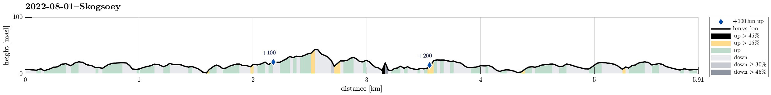 With the prediction of another nice summer day, we headed for Skogsøyna in Øygarden. After driving to Sotra in the west of Bergen, we turn northwards at the roundabout south of Kolltveit and followed road 561 all the way northwards until we turned left (in westward direction) on Ona, then following the minor road 5276 until we crossed the bridge to Skogsøyna. Since all parking places were taken near the trail head, we continued a few meters to Langholmen and parked there next to the road. We then walked the few meters back across the bridge over Langholmsundet to get to the trail head. Following the marked trail out to Skogsøytua is by now really easy (most of the previously wet areas have been covered so that it's now just a nice walk until one gets to the "high point" (at >>>
Hesjadalsnovene from Øyadalen
- Date:
- 21.07.2022
- Characteristic:
- Hike
- Duration:
- 5:00h
- Distance:
- 14.8km
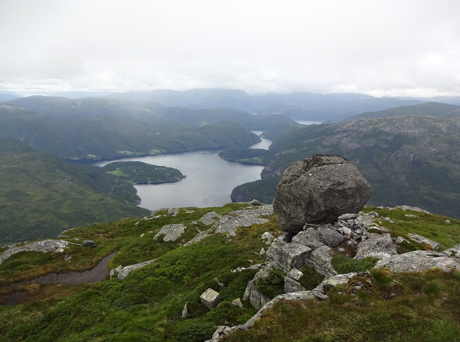 With quite some cloud cover predicted, we decided for a medium-high hike on our way back to Bergen. Driving out Eksingedalen to Eidslandet and then further along Eidsfjorden, we came to Kalland shortly after. Rounding Stamnesfjellet on the road brought us to the narrow road up from Vik to Vikadalen. Turning right right after the bridge over Vikavatnet, we arrived at the lower end of Øyadalen and parked there at a proper parking place. The map had indicated that one could choose from walking into Øyadalen either on its northwestern side, or on its southeastern one. To see it all, we decided to walk into Øyadalen on its northwestern side, first. Given the substantial amounts of rain on the day before, we quickly learned that this would turn into a very (very!) wet hike soon! :-) Yes, >>>
An attempt to Slettefjellet via Eikemostølen
- Date:
- 20.07.2022
- Characteristic:
- Hike
- Duration:
- 2:00h
- Distance:
- 4.4km
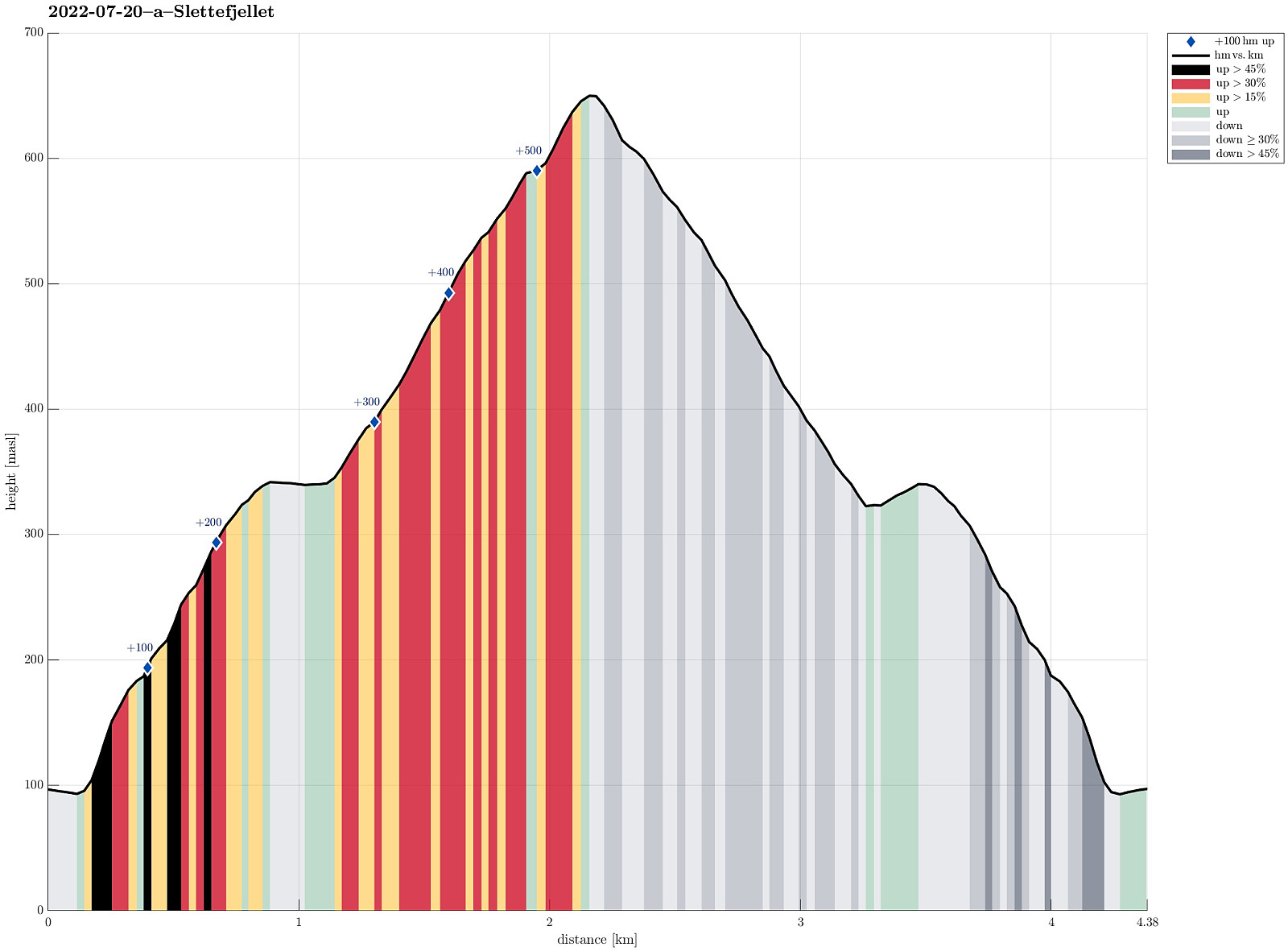 The weather forecast was not really promising, but we decided to still give it a chance. Driving down Eksingedalen and passing by the tunnel to Modalen, we soon came to Treshaugen near Eikemo, where we parked the car right next to the road. We had read up front that we should be able to locate a (steep) trail up to Eikemostølen from there and indeed we could find some blue marks on a couple of trees right next to the road near the northern bend of Ekso (in the northeast of Eikemo). Still, finding the "trail" did then require a lot of imagination (yes, a good number of trees were marked on the way up to Eikemostølen, but the "trail" was hard to see, or not, and partially covered fully with vegetation like high grass or farns). Nonetheless, it was then without major >>>
Saudalsnovi from Flatekvål in Eksingedalen
- Date:
- 19.07.2022
- Characteristic:
- Hike
- Duration:
- 6:00h
- Distance:
- 16.4km
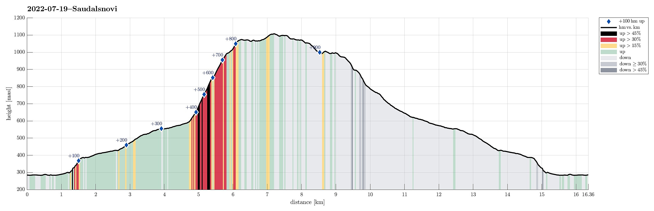 Expecting a nice day, we aimed at Saudalsnovi in the southwest of Lavik in Eksingedalen. We drove to Flatekvål, a short stretch down Eksingedalen from Lavik, and parked at the parking place for the church, Eksingedalen Kyrkje, right next to Eksingedalsvegen. From there, we walked along Sørdalsvegen, passing by the church and crossing over river Ekso close to where Sørdalen comes down on the other, southern side. After crossing the flat spot at Øyna and entering Sørdalen, we came to a few (commercial?) buildings. There, on the back-side of these buildings, we found a simple pedestrians' bridge that lead us over to the other, western side of the Sørdalselvi. There, we quickly found a marked trail that would lead us (steeply) up to the ridge above Furneslii. Once up there, at about >>>
Det Høga Bungane from Haugen
- Date:
- 18.07.2022
- Characteristic:
- Hike
- Duration:
- 2:00h
- Distance:
- 6.5km
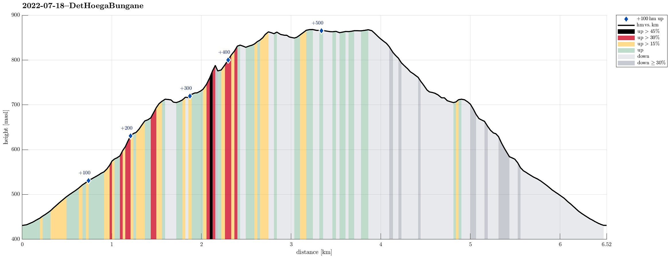 After some driving, we ended up in Lavik, Eksingedalen, in the early evening. We decided that it was still enough time for a short walk and followed a recommendation from one we had talked to in Lavik, driving up to Haugen in Fagerdalen, just northeast of Lavik. From there, we started walking, reaching Lavikstølen at the end of the gravel road leading up there from Haugen. At Lavikstølen, we still wished to include a bit more and so we continued along a trail that leads upwards (in western direction) from Lavikstølen. First, we thought that this trail would lead up to Nipa, just to find out rather quickly that the trail tended more and more into southwestern direction, instead. Once above 700mosl, it became clear that this trail would lead around some pronounced cliffs in the south >>>
