Archive - Date
Archive - Activity
-
Bike trip (120)
- Bike trip - mixed (38)
- Bike trip - road (5)
-
Other trip (1)
- Kayaking (1)
-
Other winter trip (4)
- Snowshoe trip (4)
- Ski trip (3)
- Trip by foot (728)
Archive - Geography
Peakbook-Friends
Snow-covered Liatårnet (via an unusual route)
- Date:
- 25.02.2018
- Characteristic:
- Hillwalk
- Duration:
- 2:00h
- Distance:
- 9.2km
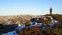
 Very nice hike over snow-covered Liatårnet! We started from the west, followed the road (towards the shooting range), before we then entered one of the main hiking paths to Liatårnet (the main route up from the west). But instead of following this path all the way up, we took a turn to the right (southeast) shortly before reaching the main west-face of Liatårnet (at about 200mosl) and connected to another, not so major path, which leads up to Liatårnet from the south. We then connected to Pyttane, walking through a lovely winter landscape, passing by Tårnavatnet. Instead of then following the main road up/down Pyttane, we continued "along the ridge towards the north" (without a path). One has to look a little, where to go, but it's quite possible (especially with enough >>>
Sauafjellet
- Date:
- 16.12.2017
- Characteristic:
- Hillwalk
- Duration:
- 2:00h
- Distance:
- 4.5km
 We took the car to Sotra and there to Fjæreide (near Knappskog). We parked near the place where seemingly also the bus turns around (more or less in the middle between Fjæreidpollen in the NE and Fjæreidvatnet in the SW). We then walked first for a few meters down the road which leads down to the water (Fjæreidpollen/Smalneset), before then turning left (following a sign from Kyststien). Within short we were in the snow and soon after we departed from the path towards Spjeldsfjellet (our plan was to get up Sauafjellet first). After quickly ascending to Fagrevollen, we connected to a ridge, which leads up to Sauafjellet in western direction. At Sauafjellet, we enjoyed some great views towards the Atlantic! We then decided to head towards Spjeldsfjellet, even though it was clear that >>>
Wet Litlesotra (very wet!)
- Date:
- 25.03.2017
- Characteristic:
- Hillwalk
- Duration:
- 3:00h
- Distance:
- 8.5km
 I took the car along road #555 towards the west from Bergen, crossing the Sotra-bridge to Litlesotra. There, I continued to Straume (where also the Sator Center is), and followed the small road #209 towards the north from there. I passed the places, where one could drive to Foldnes and to Anglavik, later, and arrived in a small place called Vågo shortly after.
I left the car in Vågo and started my hike in southern direction. Very soon, I had to leave the path, which I had started on, and continued through the wild (as expected from studying the map in advance). The first (nearby) target was Storanipa, just south of Vågo. On its western side, there are steep cliffs, but ascending to it from any of the other directions is straight forward. Next, I had already planned to cross over (in >>>
Gardafjellet and Signalen
- Date:
- 11.02.2017
- Characteristic:
- Hillwalk
- Duration:
- 3:00h
- Distance:
- 7.0km
 We took road #555 towards the west of Bergen, crossing Sotrabroen and the tunnel near Kolltveit. Turning left, right afterwards, we continued on road #555 towards Fjell, where we turned right, taking road #559 further westwards. At Ulveset, very near to the school there, we parked and started to hike.
We first followed a small road called Trippevegen in northeastern direction, up to a relatively sharp turn. There, we found the path, which leads further north (instead of following the road, which extends towards the west). We followed this path to a point, which is marked with "Litlestengelen". From there we continued without a path in northeastern direction, heading towards Gardajellet (a bit north of Kvernavatnet). Hiking was all easy (mostly because the ground was conveniently >>>
Nice hike on Vindenes
- Date:
- 04.02.2017
- Characteristic:
- Hike
- Duration:
- 3:00h
- Distance:
- 8.4km
 We drove westwards from Bergen, towards Sotra. After passing through the tunnel under Kolltveit, we turned right at the roundabout, continuing on road #561 in northwards direction. We drove through Knappskog to Ågotnes, where we left the main road at a roundabout, which also is the main entry point to the extended business area at Ågotnes, continuing on Bleivassvegen (again northwards) until we reached Vindenes. There we continued (just for very short) a little bit upwards onto the peninsula (to the northeast) until we found a suitable parking place near Vardhaugen (almost where the bus also turns).
From there, we walked, following first a smaller road that leads northwards a bit to the west from the road along with we had parked. After only a few meters, we passed by a parking spot (just >>>
Signalen
- Date:
- 18.12.2016
- Characteristic:
- Hillwalk
- Duration:
- 0:45h
- Distance:
- 2.7km
 We drove west from Bergen to Sotra and then further to Fjell, where we took the road 559 into the direction of Møvik. At the upper (eastern) end of Møvik, we parked near a supermarket on the northern side of the road (where a small road called Signalvegen leaves towards the right (north).
From there, all this short hike is pretty straight-forward: First, we followed Signalvegen upwards until we came to Signalvatnet (not quite as full as it seemingly seems to be at other times!). We followed the gravel road further until we came to the dam at the western end of Signalvatnet.
There we crossed over, using some wooden stairs that invite to step up to the hillside conveniently. Then, it's just a few steps until one reaches the upper parts of the western end of the Signal-hill. At the "top", >>>
Crossing Høgafjellet from south to north
- Date:
- 27.11.2016
- Characteristic:
- Hillwalk
- Duration:
- 2:30h
- Distance:
- 5.6km
 Since we were two families with one car each, this day, we decided to traverse Høgafjellet (from the south to the north), instead of going a round. We took road 555 from Bergen to the west (across the large Sotra-bridge) and then continued further southwards, passing through Fjell. At about N60.312, E5.082, we left one car at the parking place, from which one can access the ruins of previous fortifications (fjellfestningen). Driving further southwards, we connected then to road 204, which leads to Haganes. Instead of driving all the way to Haganes, however, we stopped at about N60.286, E5.103 and started our hike from there. We first crossed over Storhaugmyra (mostly in eastern direction), getting into a small valley, which leads upwards to Kattatjørna. There, we basically changed direction >>>
Knappskogfjellet
- Date:
- 02.10.2016
- Characteristic:
- Hillwalk
- Duration:
- 2:00h
- Distance:
- 6.4km
 We drove to Sotra and turned right (northwards) after Kolltveittunnelen. We continued on road 561 northwards until we came to Knappskog. There, we turned left and followed a narrow road to Fjæreide. We parked right next to the cross, where one enters Dalane (in southern direction). We first wished to get to a path at the southern end of Dalane, but when we got close, a man (the owner of house #194?) informed us that we were not supposed to continue, but return and aim at another path that connects to Knappskogfjellet on the eastern side of Dalane. About half the path back to the main road, we detected this path and used it to get up above Dalane and towards Knappskogfjellet. Proceeding towards Knappskogfjellet was then straight-forward (partially steep, but easy to climb up). On Knappskogfjellet >>>
Algrøyna, Smalaneset
- Date:
- 03.09.2016
- Characteristic:
- Hillwalk
- Duration:
- 2:30h
- Distance:
- 4.5km
 We drove westwards from Bergen towards the outer islands and stopped at Algrøyna (basically at the very last bus stop, there). From there, we continued into western direction, looking into Nøtevika, first. We then crossed over to the relatively large peninsula of Algrøyna, which lies between Breivika in the north and Kungvika in the south. We followed a well-marked path westwards as soon as we had reached this peninsula, following the northern coastline. Relatively quickly, we proceeded towards the outermost tip of this peninsula, Smalaneset, enjoying many great views already on the way out there. After a short rest, we returned---this time following the southern shore, along Kungvika. Back to the street (Kungvikvegen), we did not have long to go, before we were back to the car. It's >>>
Liatårnet
- Date:
- 13.05.2016
- Characteristic:
- Hillwalk
- Duration:
- 2:00h
- Distance:
- 5.1km
 We parked on the western side of Liatårnet, a few kilometers south of Fjell, where one is also informed about nearby Fjellfestningen. From there, one first follows a paved forrest road towards Liatårnet, passing by Bålesteinen, then turning right. The trail to Liatårnet leave the paved road (to the right) near a shooting arena and right next to a simple building. Then the path leads (more or less) straight up to Liatårnet (easy to find). It was a nice evening, but quite a bit windy (especially on the top)! To get back, we continued from Liatårnet southwards, descending steeply into a wet area about 100 height meters below Liatårnet. In order to get back to the paved road (further down and to the northwest from this place), one needs to look very carefully for a trail (if there >>>


