Archive - Date
Archive - Activity
-
Bike trip (137)
- Bike trip - mixed (51)
- Bike trip - road (9)
-
Other trip (1)
- Kayaking (1)
-
Other winter trip (4)
- Snowshoe trip (4)
- Ski trip (4)
- Trip by foot (740)
Archive - Geography
Peakbook-Friends


Collected lists
-
Bergen ≥ 50m pf. og ≥ 100 m.o.h.
(87/89)
 97%
97% -
Most dominating tops of the Bergen peninsula
(68/75)
90%
-
Utvalgte topper og turmål i Bergen
(316/350)
90%
-
Alle topper i Bergen
(357/398)
89%
-
Opptur Bergen
(100/113)
88%
-
De syv fjell rundt Bergen
(6/7)
85%
-
Sund ≥ 50m pf.
(14/18)
77%
-
Os ≥ 50m pf.
(25/34)
73%
-
Søyler (fastmerker) i Bergen
(68/100)
68%
-
Fjell ≥ 50m pf.
(21/32)
65%

Stendafjellet from the north
- Date:
- 29.10.2022
- Characteristic:
- Hike
- Duration:
- 1:00h
- Distance:
- 2.2km
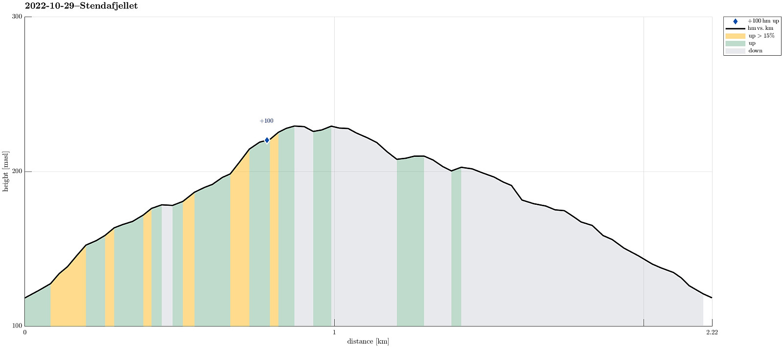 Even though it all looked (and was!) a rainy day, we still wished to get some fresh air. Since we had something else to do nearby, we decided to just quickly include a short detour up and down Stendafjellet (from the north). Driving up Øvre Krohnåsen, we found a spot to park near the playing ground at the upper end of this road. From there, we started our short hike towards the "top" of Stendafjellet, choosing a route through the forest (without a trail). All this was straight-forward and without any difficulties (at about 200masl, there's a little cliff, which is easy to get around, though). On Stendafjellet, we visited the lookout point, looking down to Fanafjorden from there, before then returning (along a similar, but still a bit different route). All in all, this was >>>
Round around Dyrdalsvatnet from Øvstebø
- Date:
- 15.10.2022
- Characteristic:
- Hike
- Duration:
- 4:30h
- Distance:
- 10.1km
 We expected a rather nice autumn day and decided to hike up to Hausdalshorgi, one of our favorite mountains near Bergen. A good way to approach Hausdalshorgi is from Øvstebø, a short way further northeast from Bontveit. The usual route leads first up to Dyrdalsvatnet (parallel to Dyrdalselva, on its northwestern side) and from there further up to Hausdalshorgi, conveniently using a little bridge over Dyrdalselva (when it's not swept away by some floods as a few years back). This time, we wished to explore an alternative approach to Hausdalshorgi, crossing Dyrdalselva already at Øvstebø, then ascending through the forest up to Bjørnaberget, and then further up along a small ridge that extends in northwestern direction from Bjørnaberget. Even though the stretch up to Bjørnaberget is >>>
Lyderhorn from Loddefjord
- Date:
- 11.09.2022
- Characteristic:
- Hike
- Duration:
- 1:30h
- Distance:
- 4.2km
 With only limited time available, we decided to "just" make a short hike to Lyderhorn, exploring a new "corner" of this rather well-known mountain. We started biking to Loddefjord. We then continued up a side road of Lyderhornsveien, which services the power facility a few meters above Loddefjord, right below Skarpafjellet. From there, we first followed the trail that leads up to Grøvledalen, but decided to follow a slightly different route up, first. Soon later, we reconnected with the trail between Skarpafjellet and Lyderhorn. From there, it was then basically up and down Lyderhorn, mostly following trails. On the way back, we then descended towards Loddefjord through Grøvledalen. Nice to explore new routes, even on an often visited mountain like Lyderhorn! :-)
Kanadaskogen with Storhovden
- Date:
- 02.07.2022
- Characteristic:
- Walk
- Duration:
- 2:30h
- Distance:
- 8.0km
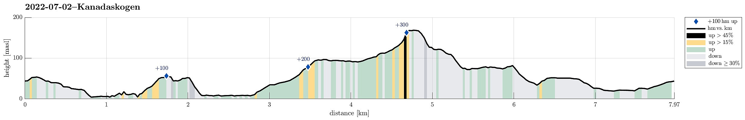 One of many rounds through Kanadaskogen, starting along Gjeddevatnet, also including Fureneset, this time, and then continuing to Bjørndalsvatnet and further to Svartatjørna. On our way back, we included Storhovden and Syningen, then passing by Stora Krokatjørna.
Selected photos are available as Google photo album .
See also the related FB-page Hiking around Bergen, Norway .
One of many rounds through Kanadaskogen, starting along Gjeddevatnet, also including Fureneset, this time, and then continuing to Bjørndalsvatnet and further to Svartatjørna. On our way back, we included Storhovden and Syningen, then passing by Stora Krokatjørna.
Selected photos are available as Google photo album .
See also the related FB-page Hiking around Bergen, Norway .
Søtefjellet from Hausdalen via Åsen
- Date:
- 25.06.2022
- Characteristic:
- Hike
- Duration:
- 4:00h
- Distance:
- 10.4km
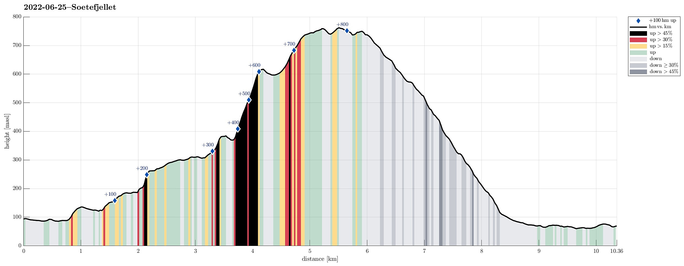 We exploited the situation of having two cars to cut short a few kilometers on the road through Samdalen. After passing by Kalandsvatnet along E39 in the south of Bergen, we turned left at Kalandseidet to continue further into Hausdalen. Right before coming to Tømmervika of Samdalsvatnet, we left one car where a forest road comes down to Hausdalsvegen. With the other car, we then continued all the way in to the end of Hausdalsvegen, where we parked at the parking spot. Given our plan to ascend Søtefjellet via Åsen, we had planned to cross Hausdalselva using a simple bridge at Hausdalen, just a few meters back along the "main road". Getting there, however, we found a sign that informed us that crossing over there was only possible with the consent of the land owner. Luckily, >>>
Kanadaskogen from Varden
- Date:
- 28.05.2022
- Characteristic:
- Hike
- Duration:
- 1:30h
- Distance:
- 4.6km
 Walk through Kanadaskogen from Varden, including Hesjaholten. After first passing by Gjeddevatnet at Skaget, we crossed over some minor hills in northern direction, coming close to Bjørndalsvatnet (but not descending all the way down to it, this time). North of Hesjaholten, we then ascended to one of the small cliffs using a narrow gully in southwards direction. We then included also a neighboring cliff (a little further towards the northeast), before heading back into the direction of Varden, including Hesjaholten along the way. It's definitely possible to experience small but nice micro-adventures in Kanadaskogen! :-)
Selected photos are available as Google photo album .
See also the related FB-page Hiking around Bergen, Norway .
Walk through Kanadaskogen from Varden, including Hesjaholten. After first passing by Gjeddevatnet at Skaget, we crossed over some minor hills in northern direction, coming close to Bjørndalsvatnet (but not descending all the way down to it, this time). North of Hesjaholten, we then ascended to one of the small cliffs using a narrow gully in southwards direction. We then included also a neighboring cliff (a little further towards the northeast), before heading back into the direction of Varden, including Hesjaholten along the way. It's definitely possible to experience small but nice micro-adventures in Kanadaskogen! :-)
Selected photos are available as Google photo album .
See also the related FB-page Hiking around Bergen, Norway .
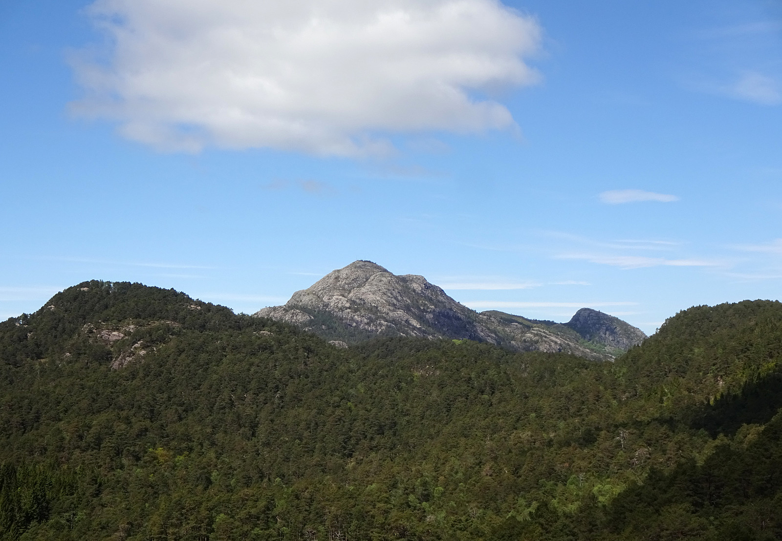
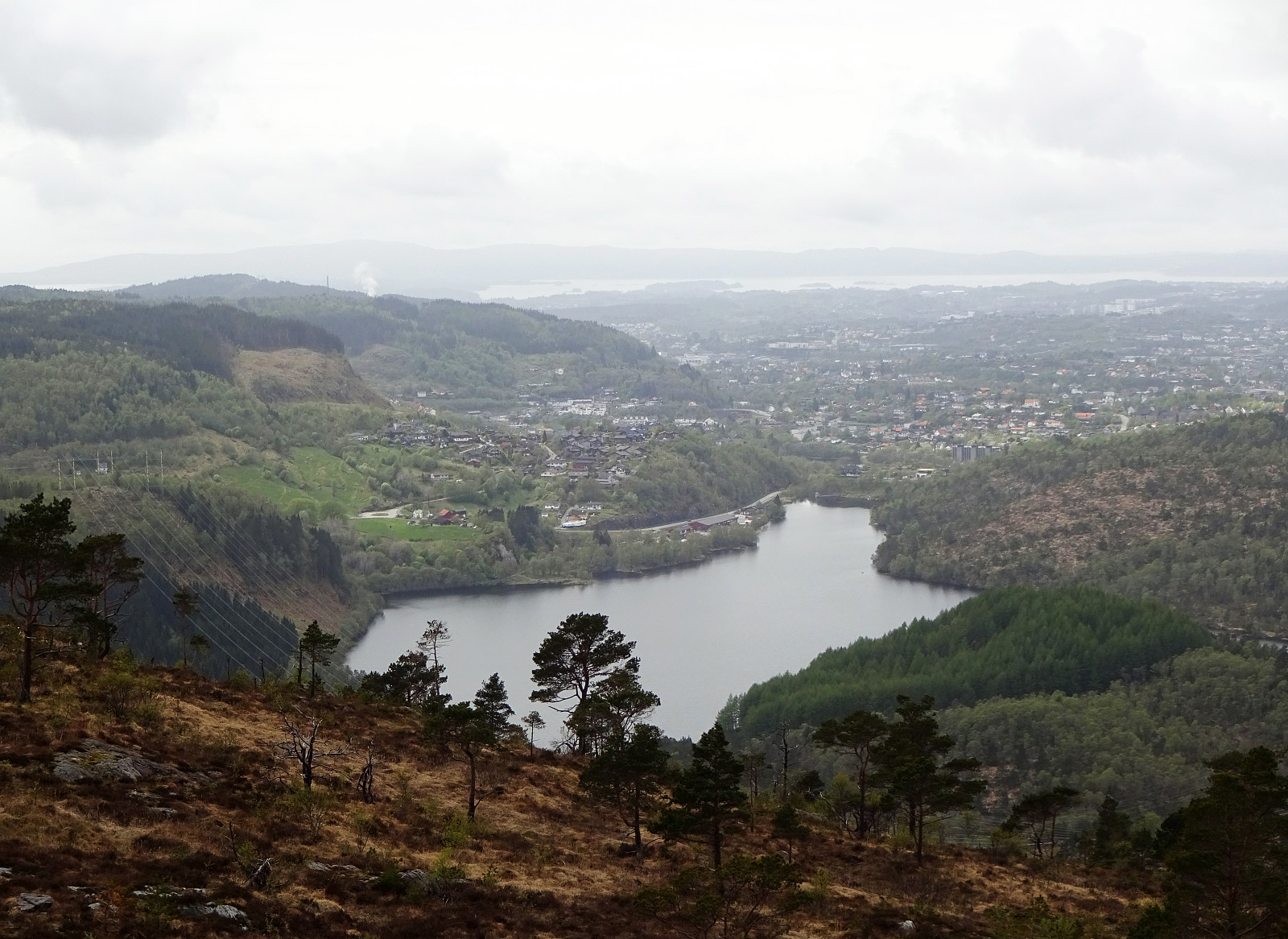
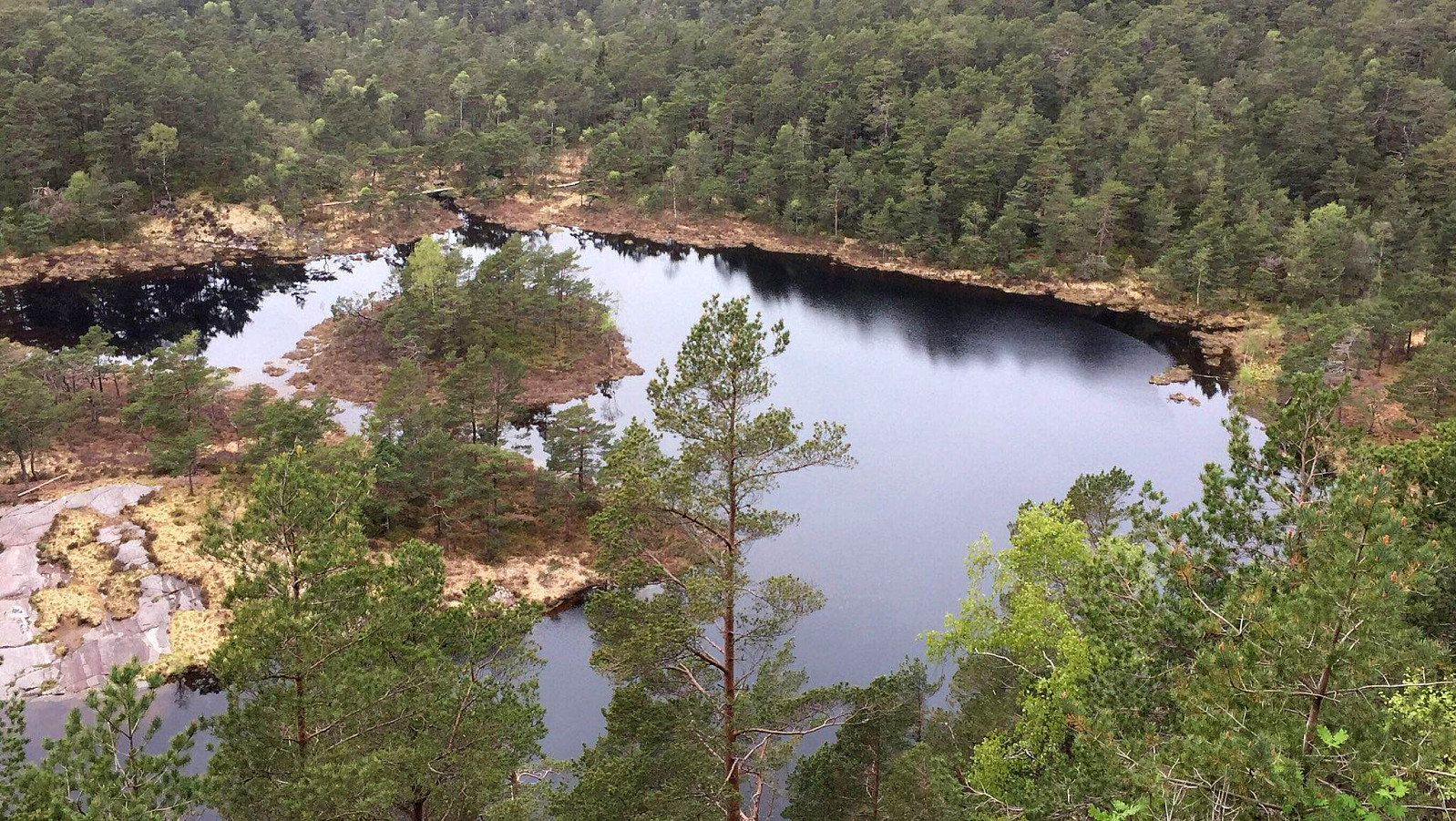
Knappen from Varden
- Date:
- 21.05.2022
- Characteristic:
- Walk
- Duration:
- 1:30h
- Distance:
- 4.6km
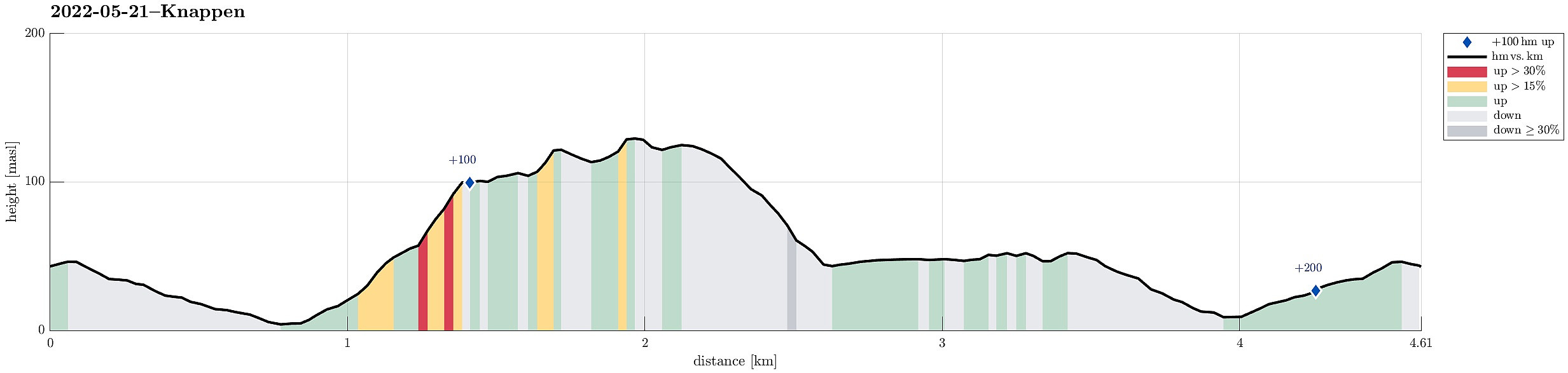 Just a standard walk over Knappen from Varden.
See also the related FB-page Hiking around Bergen, Norway .
Petter Bjørstad has a useful page about Knappen .
Web page UT.no from the Norwegian Trekking Association recommends another hike to Knappen .
Just a standard walk over Knappen from Varden.
See also the related FB-page Hiking around Bergen, Norway .
Petter Bjørstad has a useful page about Knappen .
Web page UT.no from the Norwegian Trekking Association recommends another hike to Knappen .
Skavlandsfjellet from Søyleplasset and Totlandsfjellet
- Date:
- 15.05.2022
- Characteristic:
- Hike
- Duration:
- 4:00h
- Distance:
- 11.4km
 Ascending to Brattlandsfjellet from Brattland -- a long time plan! :-) We parked in the south of Søylevatnet, where the trail from Furedalen comes down from the south. After walking around Søyleplasset along the main road, we started our ascent to Dansebakken in the southwest of Søylevatnet. While we first were quite a bit unsure regarding how challenging this ascent would be, we then found out that a nice, minor trail actually leads up via Dansebakken! :-) Steadily ascending further upwards, we arrived at Skavdalsfjellet without any difficulties. We then crossed over Skavdalsfjellet, without including Flåfjellet further in the west, surrounding Fjellklovevatnet in its east. We then descended into Furedalen via the eastern hillside of Stordalsfjellet. There, we crossed the stream >>>
Oasen from Varden and back through Kanadaskogen
- Date:
- 14.05.2022
- Characteristic:
- Walk
- Duration:
- 3:00h
- Distance:
- 10.2km
 After first walking to Oasen from Varden, I took a detour back to Varden through Kanadaskogen, including a crossing of Skjenhaugane, Langaheia, and Hesjaholten.
See also the related FB-page Hiking around Bergen, Norway .
After first walking to Oasen from Varden, I took a detour back to Varden through Kanadaskogen, including a crossing of Skjenhaugane, Langaheia, and Hesjaholten.
See also the related FB-page Hiking around Bergen, Norway .
Up Lyderhorn and further to Fyllingsdalen
- Date:
- 24.04.2022
- Characteristic:
- Hike
- Duration:
- 2:30h
- Distance:
- 8.2km
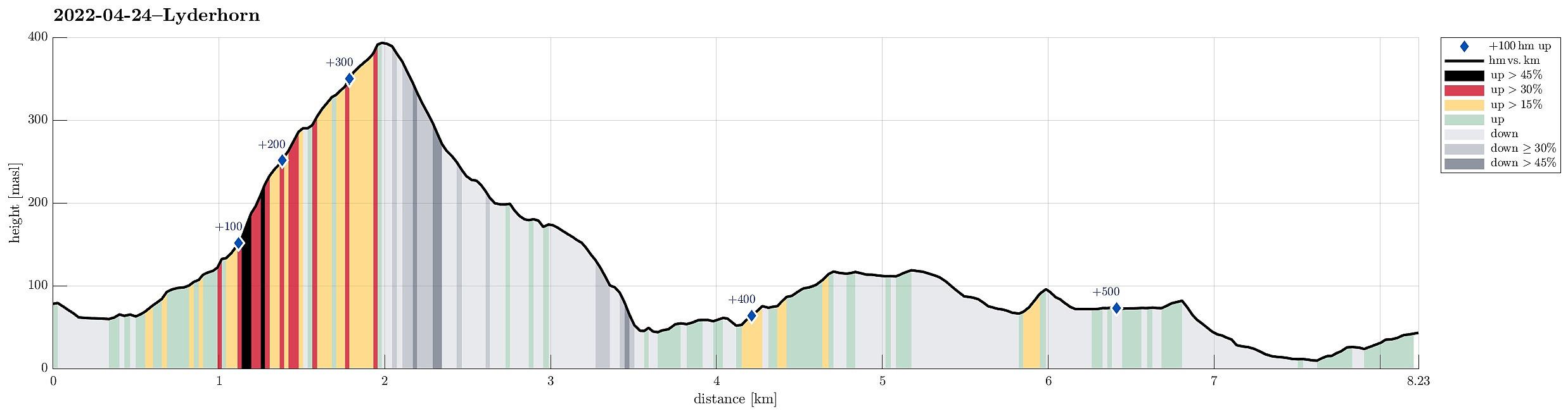 Hiking Lyderhorn and walking back to Fyllingsdalen from there. We took a bus via Loddefjord that was heading towards Olsvik, getting off where Olsvikskjenet is connected to Gamle Kjøkkelvikveien. Walking down there, we could easily connect to Lyderhornslien on the other, eastern side. From there, we then ascended to Lyderhorn following a minor trail that leads up a little further north than the main trail from Kjøkkelvik. Once on Lyderhorn, we continued in southern direction down again (into the direction of Skarpafjellet). When reaching the saddle right north of Skarpafjellet, we turned left and descended to the main highway-cross in the southeast of Lyderhorn. On the other side, we then walked up to Tennebekktjørna and further over to Spelhaugen. All in all, a nice hike connecting >>>
