Archive - Date
Archive - Activity
-
Bike trip (137)
- Bike trip - mixed (51)
- Bike trip - road (9)
-
Other trip (1)
- Kayaking (1)
-
Other winter trip (4)
- Snowshoe trip (4)
- Ski trip (4)
- Trip by foot (740)
Archive - Geography
Peakbook-Friends


Collected lists
-
Bergen ≥ 50m pf. og ≥ 100 m.o.h.
(87/89)
 97%
97% -
Most dominating tops of the Bergen peninsula
(68/75)
90%
-
Utvalgte topper og turmål i Bergen
(316/350)
90%
-
Alle topper i Bergen
(357/398)
89%
-
Opptur Bergen
(100/113)
88%
-
De syv fjell rundt Bergen
(6/7)
85%
-
Sund ≥ 50m pf.
(14/18)
77%
-
Os ≥ 50m pf.
(25/34)
73%
-
Søyler (fastmerker) i Bergen
(68/100)
68%
-
Fjell ≥ 50m pf.
(21/32)
65%

Mor Si Grav (and Bergshaugen)
- Date:
- 05.08.2020
- Characteristic:
- Hillwalk
- Duration:
- 1:30h
- Distance:
- 4.9km
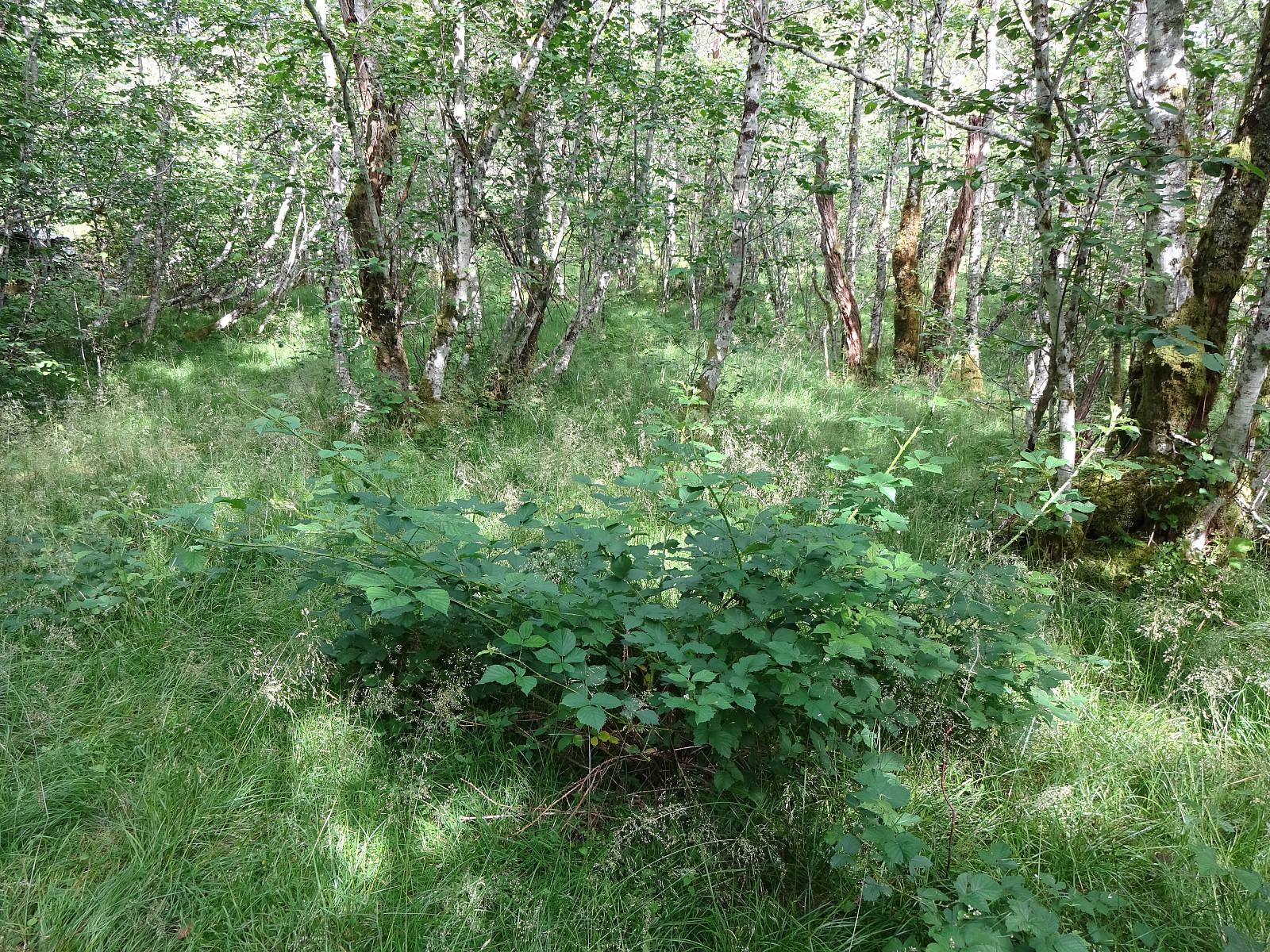
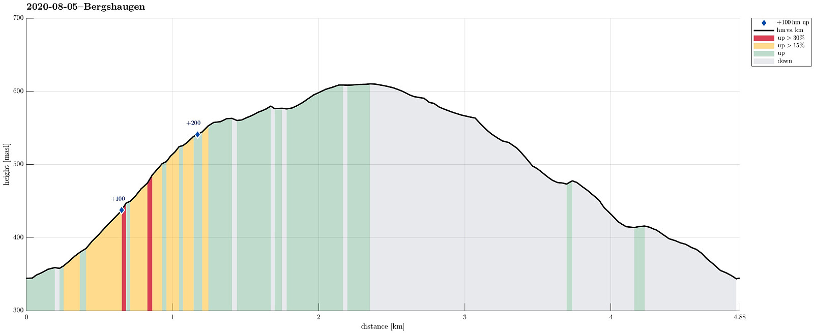 Again and again we had passed by (without stopping) before, so this time, on a rainy day, we decided to stop and take look at "Mor Si Grav" in Oppheim. We parked near the church and walked the few meters up to the old graveyard, where only "Mor Si Grav" (the mother's grave) remains. It's the place where the mother of Per Sivle is buried and an info plate not far from the grave explains some of the (quite moving!) history around it. After taking our time there, we then appended a little round around Bergshaugen, walking first up the hill and then over (at about 550mosl) to Uresåsen. From there, we then followed a gravel road (behind Bergshaugen) to Kvernhusholene. From there, we started our descent, first on the right (northern) side of Gryteelvi. At about 475mosl, >>>
Nessteinen from Mundheim
- Date:
- 25.07.2020
- Characteristic:
- Hike
- Duration:
- 5:00h
- Distance:
- 8.4km
 Having been "in the area", we decided to include a hike up to Nessteinen (or Steinen), expecting some nice views over Hardangerfjorden from up there. Another reason for choosing something not more extensive was the expectation of an overcast day with somewhat unstable weather. We drove the very nice road 49 from Norheimsund southwards (first around Visoldo to Strandebarm and then further southwards along Daurmålsegga to Mundheim). In Mundheim, we parked and started our hike first for a few meters northwards along road 48. At Oppheim, we crossed Storelva and walked up a simple field road to about 50mosl, where the field road meets the forest. From there, we continued along an not really used forest road, leading diagonally upwards (in eastern direction). At about 75mosl, however, >>>
Skrott and Breidablik from Fitjadalen
- Date:
- 24.07.2020
- Characteristic:
- Hike
- Duration:
- 5:30h
- Distance:
- 12.5km
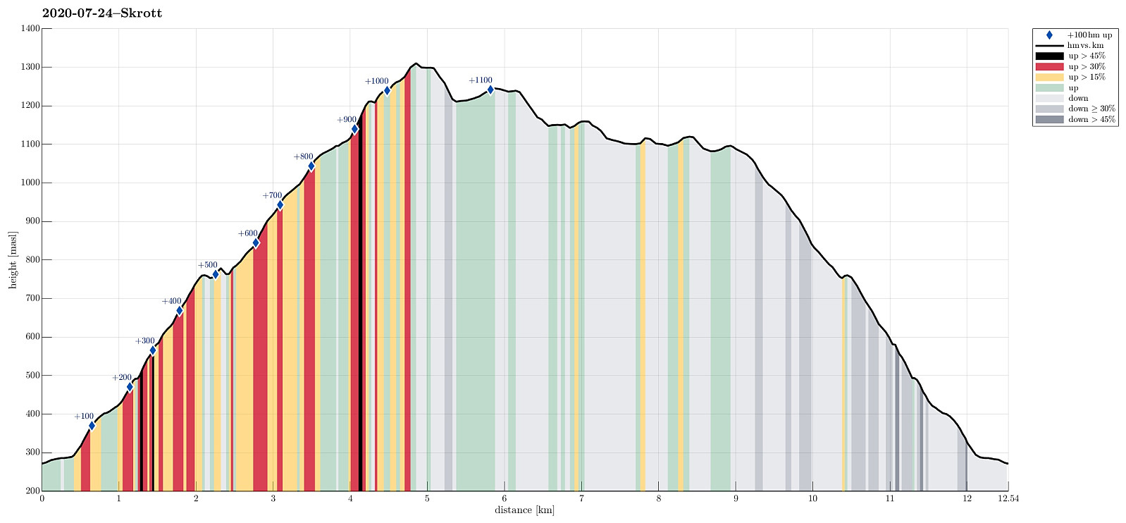 Expecting a nice summer day, we headed into the direction of Hardanger. Our plan was to ascend to Skrott, starting from Fitjadalen. After first driving to Øystese, via Kvamskogen, we turned into a northwards direction in Øystese, ascending east of Øysteseelva towards Fitjadalsvatnet. After rounding Fitjadalsvatnet on its eastern side, we parked at Fitjadalen and started hiking along the nicely marked trail leading up to Breidablik via Håsete and Vindskjersleitet. One first walks a bit "kind of" level until crossing Kjølo, coming down from Smørdalen, before then starting a significant ascent into the direction of Håsete. All in all, there isn't too much interesting to write about this trail, rather than that it's straight-forward to follow. At Håsete, we deviated for >>>
Tåkenuten and Kråkenos
- Date:
- 23.05.2020
- Characteristic:
- Hike
- Duration:
- 6:15h
- Distance:
- 13.4km
 Weighing the weather forecast with our wish to make a nice hike, we ended up with Kråkenos as our hiking goal. While this mountain is also well accessible from its eastern side (from Bru near Strandebarm at Hardangerfjorden), we decided to approach it from its western side, i.e., from Øvre Hålandsdalen. To get there, we drove from Bergen first along E16 into the direction of Voss, then along road 49 into the direction of Kvamskogen, before then continuing along road 48 to Eikelandsosen and from there further towards Holdhus a few kilometers in the east of Eikelandsosen. Near Holdhus one needs to take a sharp turn to the left (north) onto an old and narrow road that leads into Øvre Hålandsdalen (after first passing between Gjønavatnet in the north and Skogseidvatnet in the south). >>>
Gråsida from Gjelle to Hornaberg
- Date:
- 08.09.2019
- Characteristic:
- Hike
- Duration:
- 6:45h
- Distance:
- 19.6km
 Expecting nice September weather, we planned for a slightly longer hike, crossing Gråsida near Voss from one side to the other. In order to arrange for this, we agreed to coordinate this hike with friends, who would do the same hike, but in the other direction. The idea was to then exchange car keys at the meeting point so that each party could pick up a car at the end of the hike and drive back to Bergen. Our direction meant to start at Gjelle (south of Vossavangen) and to cross Gråsida towards Hornaberget in Bergsdalen. According to the plan, our friends started at Hornaberget and aimed for Gjelle, where we had parked our car (we had first taken road #5394 from Vossavangen towards Gjernes, before then driving up Giljavegen until we parked at about 285mosl, where a gravel road starts >>>
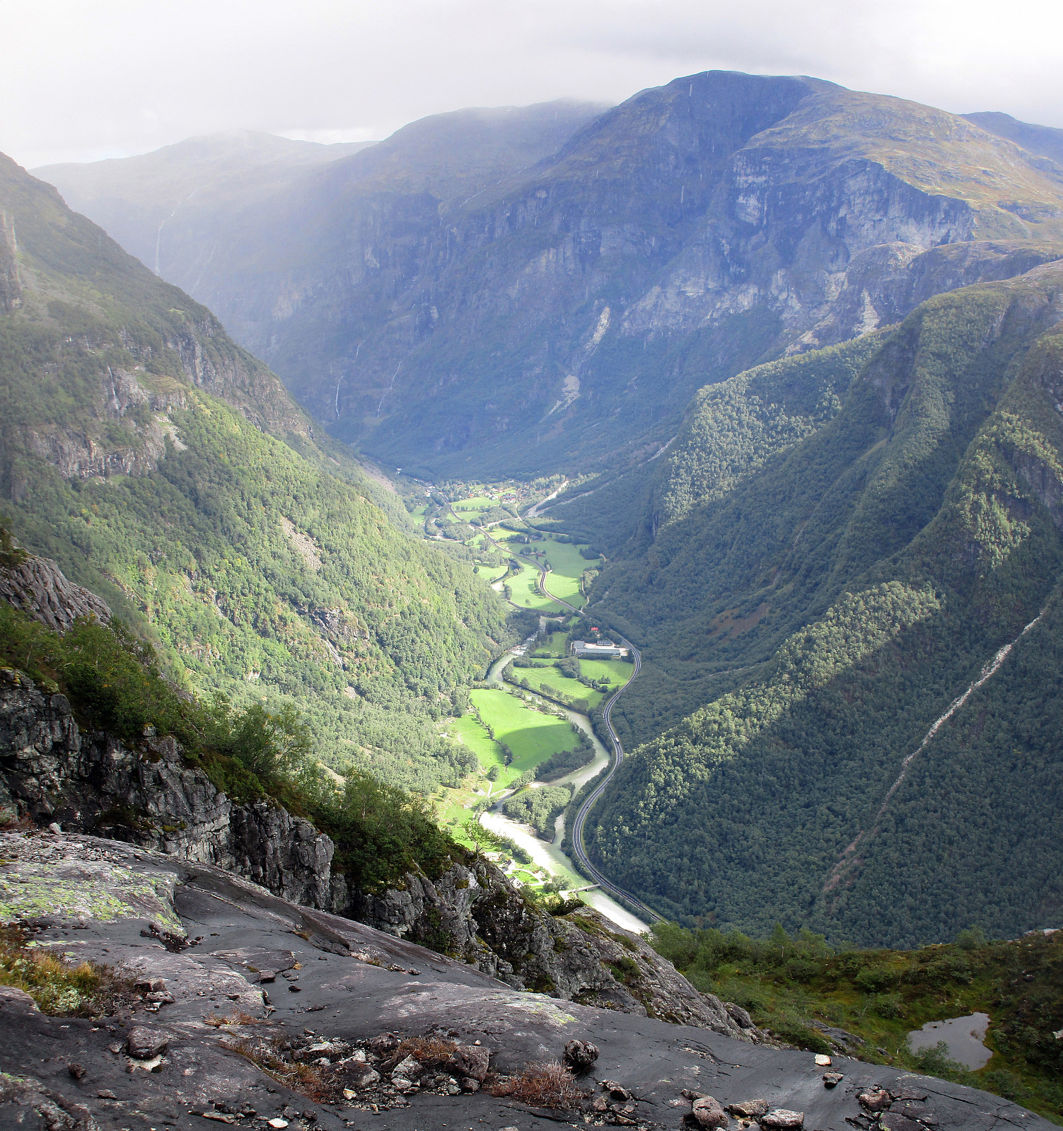
Skorseteggi and Kolingseggi
- Date:
- 15.06.2019
- Characteristic:
- Hillwalk
- Duration:
- 4:00h
- Distance:
- 10.7km
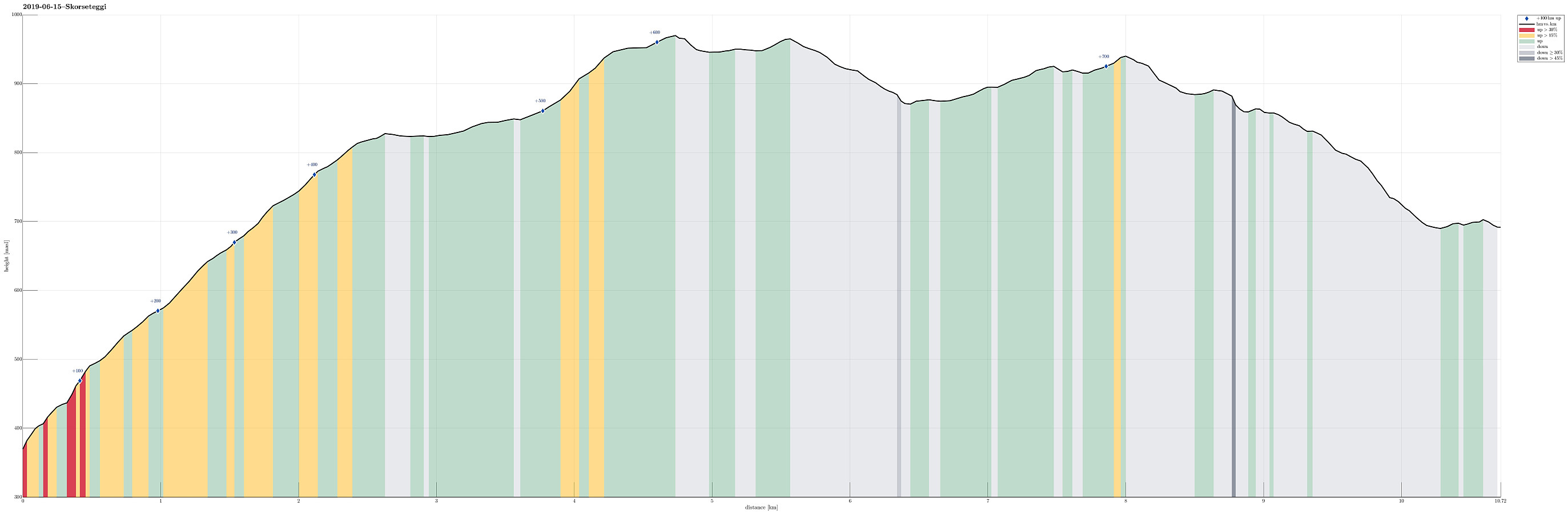 We used the advantage of having two cars this time and parked one of them near Liaset, north of Lemme and east of Lønavatnet (all near Voss). Note that you have to pay a small fee for driving the last stretch up to Liaset (NOK 20, I think), so having some coins ready may help. We then drove back to the northern side of this mountain ridge and parked near Øyjordi (near Oppheimsvatnet), where a nicely marked trail starts (back to Lemme). Following this easy-to-find trail, we ascended swiftly to Øyjordsstølen, first, and from there then further into the direction of Skorseteggi, passing by Øyjordtjørni (and Flatafjellet behind it) on our way up. Enjoying a perfect hiking day with lots of sunshine and pleasant temperatures, we spent some bonus time on the top of Skorseteggi -- simply >>>
Jordalsnuten from Jordalen
- Date:
- 25.08.2018
- Characteristic:
- Hillwalk
- Duration:
- 3:30h
- Distance:
- 5.8km
 We took road E16 into direction of Gudvangen first and turned to the left (towards Jordalen) after descending into Nærøydalen below Stalheim. We then drove through the new tunnel (now on the eastern side of the valley) up to Jordalen. After leaving the tunnel, we crossed one bridge immediately, before parking the car just ahead of the next bridge. From there we hiked, first over the bridge to the other side of Jordalselvi (to its eastern side), then southwards along the steep eastern side of the valley (into the direction of Jordalsnuten), following a proper path (note that the trail head is not really easy to see; we needed a bit of searching until we found it). It's interesting, also, that the path leads first (more or less) horizontally (with quite a bit of up and down, though) out >>>
Finnbunuten
- Date:
- 15.10.2016
- Characteristic:
- Hillwalk
- Duration:
- 5:00h
- Distance:
- 10.2km
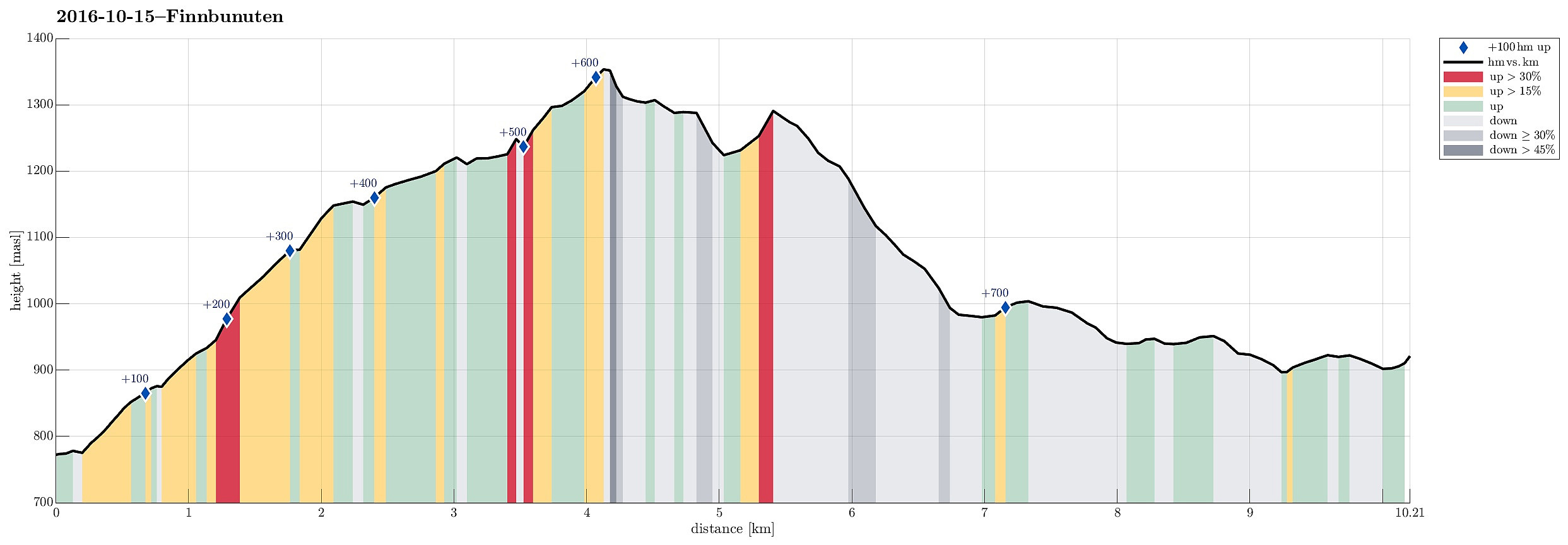 We left E16 northeast of Voss and took road 13 to the north in the direction of Myrkdalen, Vikafjellet. We passed Myrkdalen and the ski center north of it, driving into Holedalen. At the very end of that valley, the road winds steeply upwards at Halsabakkane with the help of four u-turns. Only shortly after, we parked (near Samecampen at Vikafjellet) and crossed the Sendo stream using the rest of a small bridge that leads over to the other, southwestern side. A few minutes later, we reached a place called Finnbuene, where previously people stayed in summer. From there, we continued in southeastern direction towards the edge above Holedalen. While ascending, we slowing changed to a more southern course, heading into the direction of Kaldavatnet. Hiking this part of this trip is straight >>>
Tveitakvitingen from Tveita
- Date:
- 09.10.2016
- Characteristic:
- Hillwalk
- Duration:
- 7:00h
- Distance:
- 16.4km
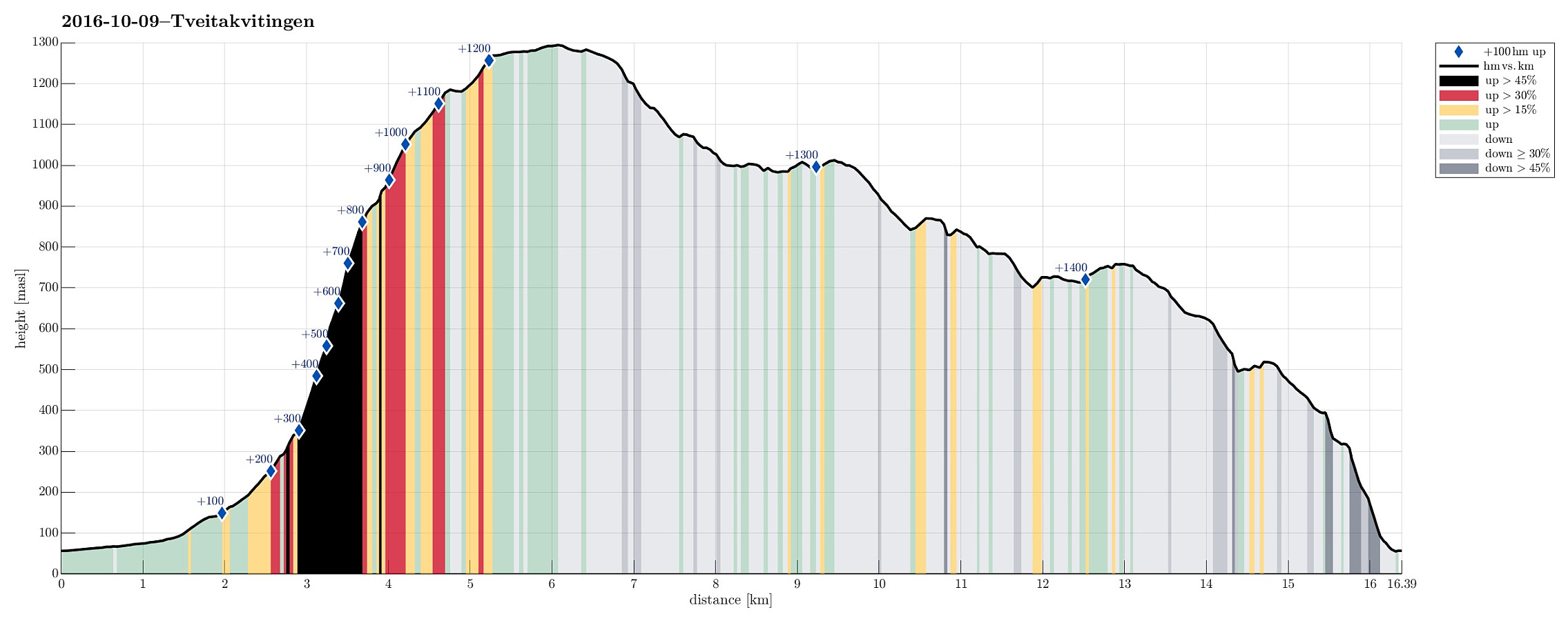 We took E16 from Bergen to Trengereid, then following road number 7 to Samnanger, before changing over to road number 48 right after Hagaåstunnelen. We passed through Eikelandsosen and continued to Holdhus, where we changed to a small road, which would lead us into the Tveita valley. Once there, we continued almost all the way in and parked near Bratthus, close to Indre Tveita. From there, we walked the rest of the road into the end of this nice valley, passing the last farm at Brekka soon after. The way continues into Tveitaskaret, where it becomes steep very soon (but easy to hike---mostly, because a gravel road has been constructed---probably to help maintaining a small power station that was opened in Tveitaskaret in 2009). At the end of the gravel road, one can further ascend through >>>
Tørviknuten and Visoldo
- Date:
- 04.09.2016
- Characteristic:
- Hillwalk
- Duration:
- 6:30h
- Distance:
- 17.6km
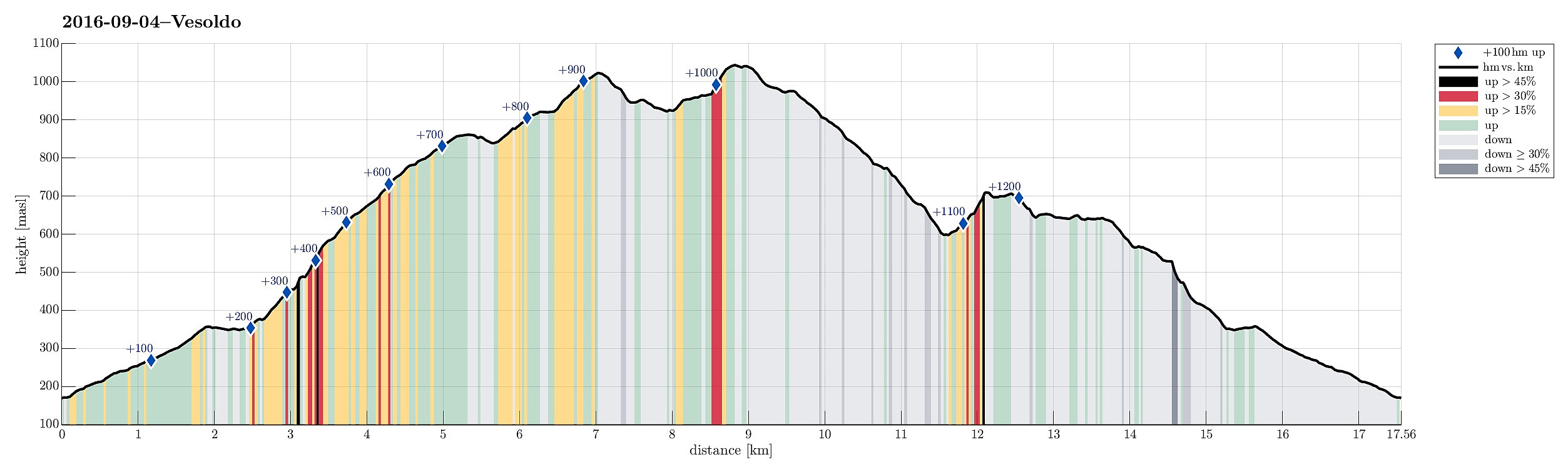 We took FV7 from Bergen towards Hardanger and turned right in Nordheimsund, following road 49 from there. We passed Tørvikbygd and when we had Eidesvatnet to our left, we entered a very small and narrow road, leading up to Åse. We parked a few meters above the farm and started to walk along a forrest road that extends further up from there. As we got higher on this forrest road, we started to pay attention to where a suitable path would take off (to the left and up). When passed Åsstølen (on the right), we started to be particularly curious, but still no inviting opportunity appeared on our left-hand side. Eventually, we decided to walk all the forrest road up (and over a small saddle right west of Hågeli), leading towards a place, where they obivously deal with some sheep, or the >>>
