Archive - Date
Archive - Activity
-
Bike trip (137)
- Bike trip - mixed (51)
- Bike trip - road (9)
-
Other trip (1)
- Kayaking (1)
-
Other winter trip (4)
- Snowshoe trip (4)
- Ski trip (4)
- Trip by foot (740)
Archive - Geography
Peakbook-Friends


Collected lists
-
Bergen ≥ 50m pf. og ≥ 100 m.o.h.
(87/89)
 97%
97% -
Most dominating tops of the Bergen peninsula
(68/75)
90%
-
Utvalgte topper og turmål i Bergen
(316/350)
90%
-
Alle topper i Bergen
(357/398)
89%
-
Opptur Bergen
(100/113)
88%
-
De syv fjell rundt Bergen
(6/7)
85%
-
Sund ≥ 50m pf.
(14/18)
77%
-
Os ≥ 50m pf.
(25/34)
73%
-
Søyler (fastmerker) i Bergen
(68/100)
68%
-
Fjell ≥ 50m pf.
(21/32)
65%

Kjerringafjellet from Heggland and Borgafjellet
- Date:
- 04.02.2024
- Characteristic:
- Hike
- Duration:
- 4:00h
- Distance:
- 6.9km
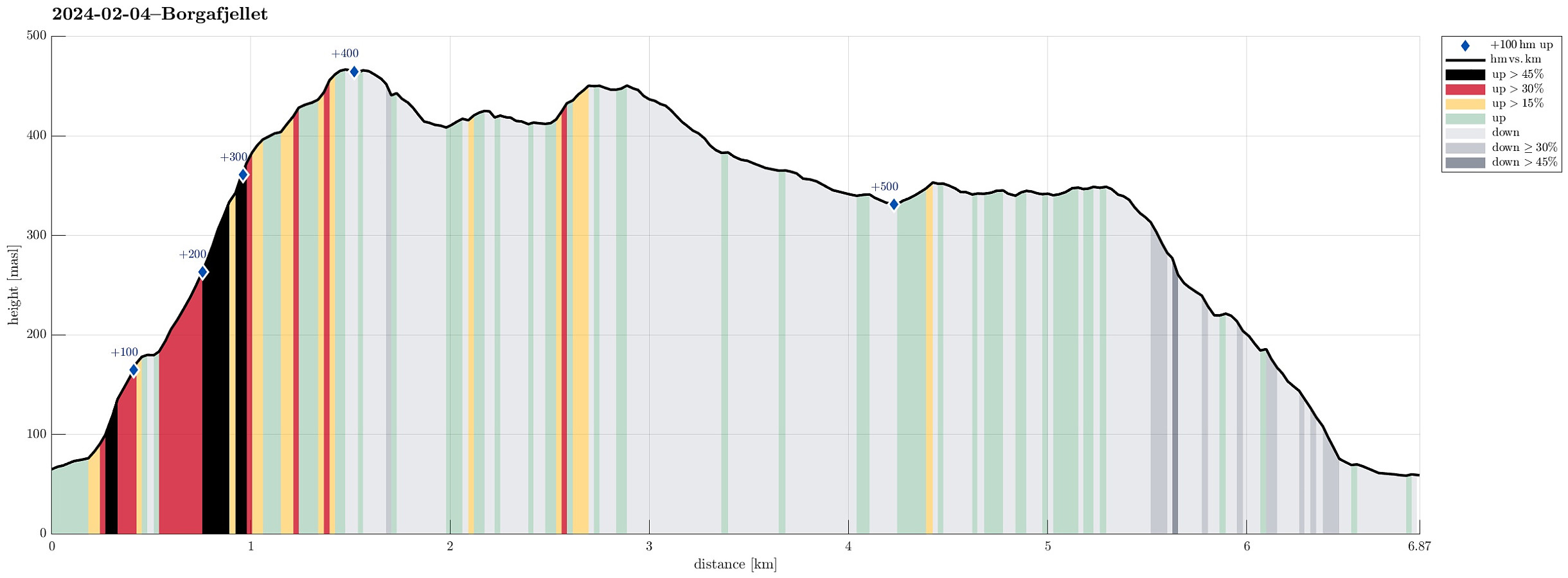 Thinking about snow at higher elevation, we made a plan for a hike that would not lead us so much up, altogether. Still, we aimed at something interesting: Hiking towards (not all the way up to, though) Møsnuken from Heggland. During an earlier hike, a sign was seen that pointed towards Møsnuken at Heggland (near Hegglandsdalsvegen in the northeast of Osøyro). The map shows an approximate trail (leading up to Hegglandstjørna), but no details are to be seen. Exploiting the fact that we came with two cars, we parked one near the planned end of the hike (below Borgafjellet) and then took the other one further along Hegglandsdalsvegen to park near Heggland. Indeed we quickly found the trail-head, again, at Heggland and started the ascent from there. The southeastern side of Møsnuken, >>>
Møsnuken from Heggeland and Gjemdalsskaret
- Date:
- 06.08.2023
- Characteristic:
- Hike
- Duration:
- 3:00h
- Distance:
- 7.9km
 We thought that crossing over Møsnuken from Gjemdal / Heggeland (in the east) to Krokvatnet (in the north) and then returning via Gjemdalsskaret back to the starting point sounded like a nice idea. :-) Accordingly, we took the new E39 connection from Bergen to Osøyro, just to continue into Hegglandsdalen from there (road 579). After passing by Tveitavatnet, we found a place to leave our car (quite near to where Spannsteigselva comes down from Gjemdalsskaret). Instead of following the gravel road up to Gjemdalsskaret from Gjemdal (to then connect to the trail that leads up to Tveitaskaret), we aimed at an ascent route through the forest in the west of Spannsteigselva (without trail). Near house #659 along Hegglandsdalsvegen we stepped onto a simple field road, leading steeply upwards into >>>
Rindafjellet from Gåssand (wow!)
- Date:
- 21.05.2023
- Characteristic:
- Hike
- Duration:
- 8:00h
- Distance:
- 17.0km
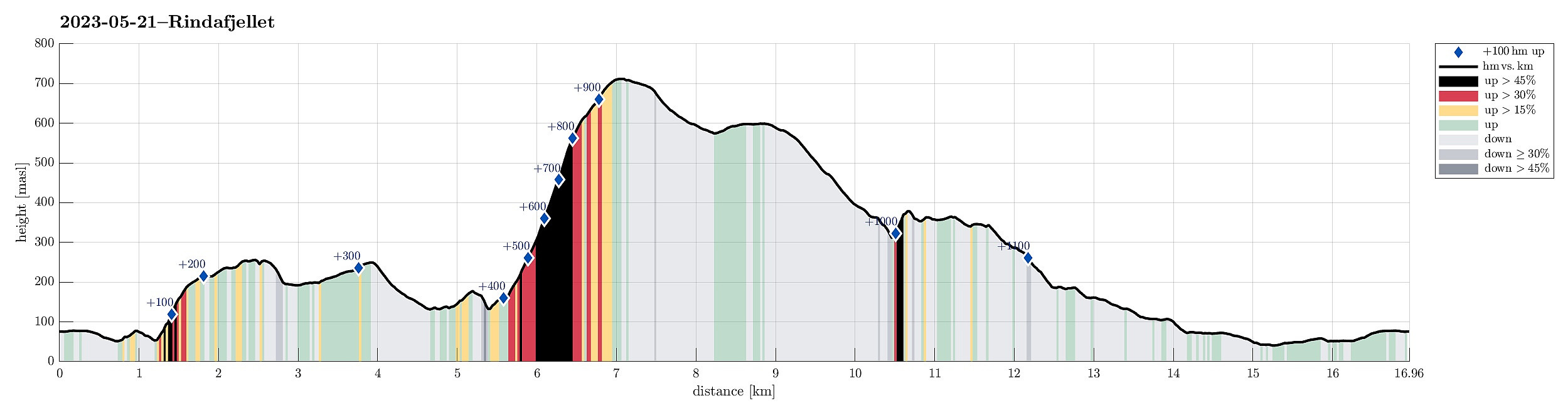 We expected a nice Sunday and headed out for a special "project": Rindafjellet from Gåssand! This clearly became a bit of an adventure and (quite) a bit of a challenge, also. It may be good to read the following before possibly retracing our hiking track (the hike was very nice, yes, but also a bit long and very steep up to Rindafjellet!).
We drove south from Bergen (along E39 into the direction of Os) and took the small road that leads to Gåssand, after all. Before actually coming to the south end of Ytsta Raudlivatnet, however, we parked at the relatively large parking spot near Hatlelia. From there, we then first walked further along Gåssandvegen, crossing Nordelva north of Gåssand. At the other side of the bridge, we turned left and followed a track across Nauslia that >>>
We expected a nice Sunday and headed out for a special "project": Rindafjellet from Gåssand! This clearly became a bit of an adventure and (quite) a bit of a challenge, also. It may be good to read the following before possibly retracing our hiking track (the hike was very nice, yes, but also a bit long and very steep up to Rindafjellet!).
We drove south from Bergen (along E39 into the direction of Os) and took the small road that leads to Gåssand, after all. Before actually coming to the south end of Ytsta Raudlivatnet, however, we parked at the relatively large parking spot near Hatlelia. From there, we then first walked further along Gåssandvegen, crossing Nordelva north of Gåssand. At the other side of the bridge, we turned left and followed a track across Nauslia that >>>
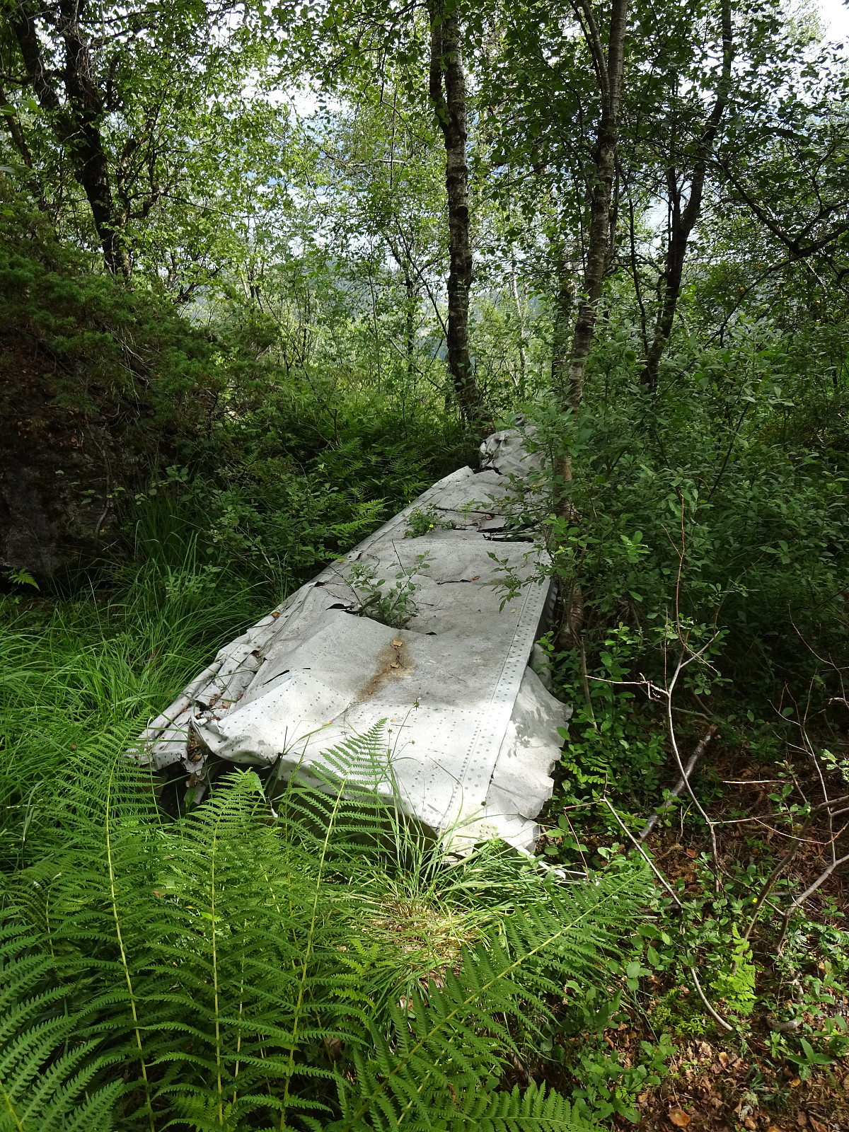
Nordra Såta, Tyssdalsfjellet, and Borgafjellet
- Date:
- 26.03.2023
- Characteristic:
- Hike
- Duration:
- 4:00h
- Distance:
- 11.4km
 For a longer time, we had considered to visit Nordra Såta in the west of Tyssdalsfjellet (and Møsnuken). To do that, we drove to the parking spot at the lower end of Tyssdalen east of Tyssdalsvatnet (northeast of Ulven). Instead of following the main trail (up through Tyssdalen), we headed north (or even northwest) after crossing Tyssdalselva. We first followed the road (Tøsdalsvegen) for a short stretch until we crossed another minor stream there. There, in the south of Lyhaugen, we left the road and ascended first to a small hill south of Lyhaugen (with a post of a power line up there). It was a bit steep to get up there and one may wonder what it's worth this effort (or any, actually). :-) We then continued to Lyhaugen (also a bit steep, but also without actual problems). From >>>
Gråfjellet via Solbjørgfjellet from Rolsvåg
- Date:
- 05.03.2023
- Characteristic:
- Hike
- Duration:
- 6:00h
- Distance:
- 14.2km
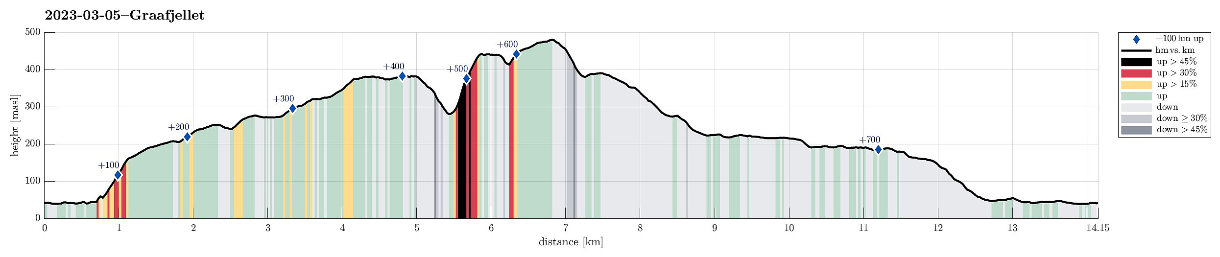 Expecting a nice day, we made a plan for a hike that would not lead us up into all too much snow. Having seen that Botnahytto (in the southwest of Rolsvåg, north of Os) was registered as war memorial, also, we decided to explore this area, including Gråfjellet in the east of Øvredalsvatnet. We had seen that others had taken the forest road from Rolsvåg (passing Rolsvågvatnet, also called Storavatnet, in its north) to get into the valley with Langavatnet and Botnavatnet. Motivated to make this a round, instead, we decided to start our hike in the south of Rolsvågvatnet, aiming for Solbjørgfjellet first. We parked very near to Rolsvågvatnet (on the east of it) and stepped into the terrain south of Rolsvågvatnet more or less "at once". The ground was still quite a bit frozen, >>>
Ulvenfjellet and Vardafjellet
- Date:
- 18.02.2023
- Characteristic:
- Hike
- Duration:
- 2:30h
- Distance:
- 5.7km
 It had been a (quite long) while since we last had visited Ulvenfjellet near Os (almost 15 years). This time, we considered an ascent from its northside, starting at Drangsvegen. We found a suitable place for parking near the bridge over Vikelva. From there, the first goal was to get up to Søvikfjellet. We ascended more or less directly up towards Søvikfjellet (without a trail and across relatively steep terrain). Doing so, we also crossed over a forest road that comes up from Helleskaret, providing another (less adventurous) way up. Once on the heights of Søvikfjellet, we aimed at Gaddhaugen as our next goal. While heading there, we connected (for a short stretch of our hike) with the trail, which is the extension of the forest road that we had crossed a bit further down. To get >>>
Møsnuken from Hegglandsdalen barneskole
- Date:
- 03.12.2022
- Characteristic:
- Hike
- Duration:
- 4:00h
- Distance:
- 12.0km
 YR predicted a really nice winter day: a perfect invitation to get out! :-) Without too much comparison of all the possible nice hikes, I decided to make another attempt to ascend to Møsnuken from the southeast. I had read here on Peakbook about a trail that leads up to Tveitaberget from Hegglandsdalsvegen where it passes the primary school of Hegglandsdalen (Hegglandsdalen barneskole). And indeed there's a proper trail with a well-marked trail head next to house #528 along Hegglandsdalsvegen, which leads up along a curved ridge to Tveitaberget. According to the terrain, this trail is very steep, but just fine to step up there! :-) Once on Tveitaberget, the trail "flattens out" a little, leading then in northward direction. At about 355masl, the trail turns left to ascend steeply (for just a >>>
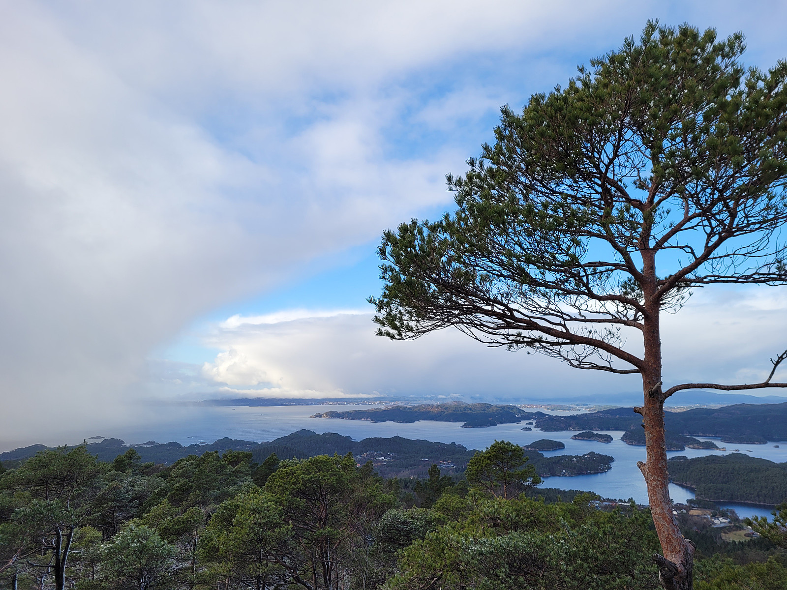
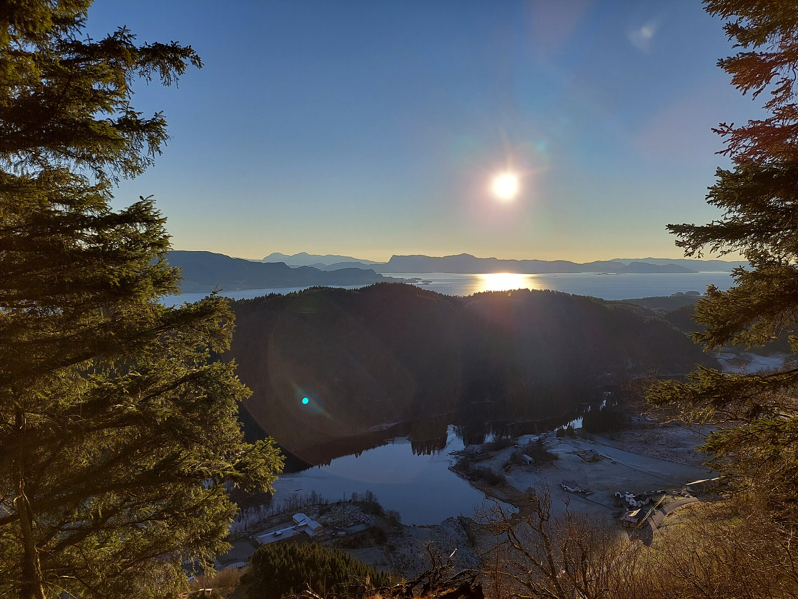
Lyshornet from Lysekloster
- Date:
- 03.09.2022
- Characteristic:
- Hike
- Duration:
- 2:30h
- Distance:
- 7.3km
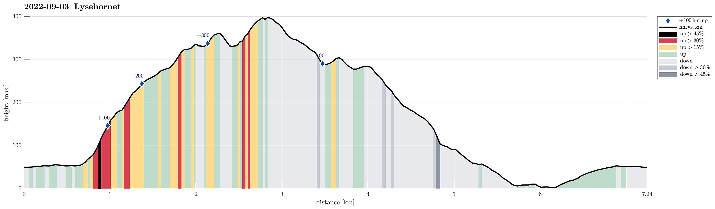 To get some fresh air, we decided to do a simple hike, not far from home: Lyshornet. We parked near Lysekloster and followed the main trail to Lyshornet from there. This lead us up to Lyshornskaret from where a short detour to Vetla Lyshornet was included. After enjoying the day for a moment on Lyshornet, we then started our hike down, following a trail towards the west from the top. This trail leads one down to the service road, which leads up to Ulvvatnet from Lyseklostervegen. Once on this road, it was then to first walk it down, before then following Lyseklostervegen back up to where we had parked. Clearly a nice little round with some nice views from Lyshornet.
Selected photos are available as Google photo album .
See also the related FB-page Hiking around Bergen, Norway .
Petter Bjørstad has a useful page about Lysehornet and also web page WestCoastPeaks.com provides useful information about Lysehornet .
Web page UT.no from the >>>
To get some fresh air, we decided to do a simple hike, not far from home: Lyshornet. We parked near Lysekloster and followed the main trail to Lyshornet from there. This lead us up to Lyshornskaret from where a short detour to Vetla Lyshornet was included. After enjoying the day for a moment on Lyshornet, we then started our hike down, following a trail towards the west from the top. This trail leads one down to the service road, which leads up to Ulvvatnet from Lyseklostervegen. Once on this road, it was then to first walk it down, before then following Lyseklostervegen back up to where we had parked. Clearly a nice little round with some nice views from Lyshornet.
Selected photos are available as Google photo album .
See also the related FB-page Hiking around Bergen, Norway .
Petter Bjørstad has a useful page about Lysehornet and also web page WestCoastPeaks.com provides useful information about Lysehornet .
Web page UT.no from the >>>
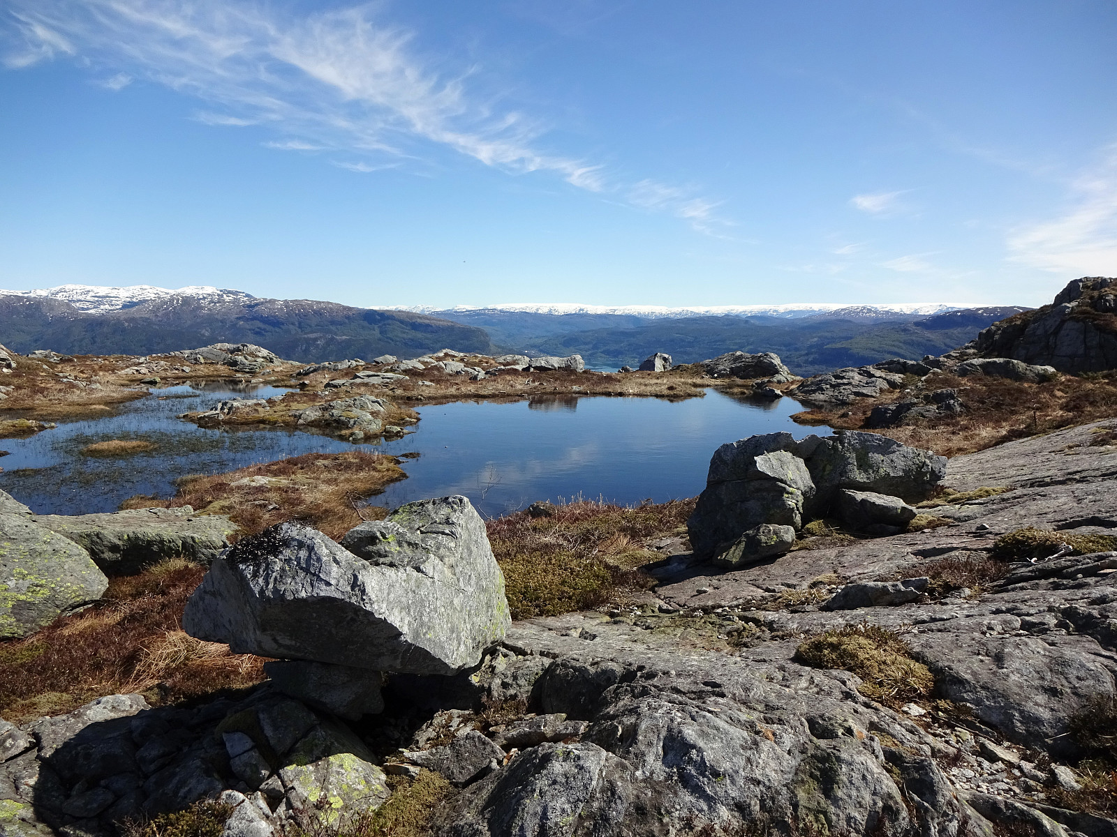
Søtefjellet from Hausdalen via Åsen
- Date:
- 25.06.2022
- Characteristic:
- Hike
- Duration:
- 4:00h
- Distance:
- 10.4km
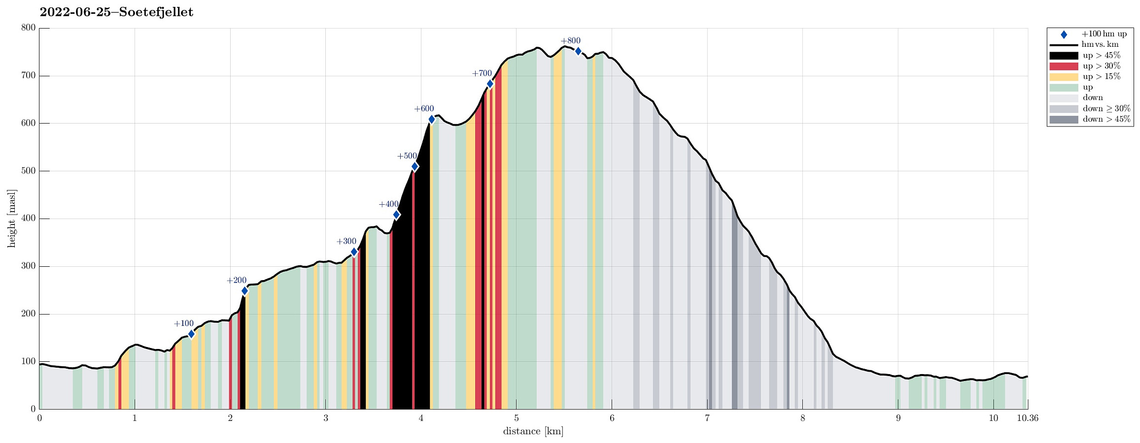 We exploited the situation of having two cars to cut short a few kilometers on the road through Samdalen. After passing by Kalandsvatnet along E39 in the south of Bergen, we turned left at Kalandseidet to continue further into Hausdalen. Right before coming to Tømmervika of Samdalsvatnet, we left one car where a forest road comes down to Hausdalsvegen. With the other car, we then continued all the way in to the end of Hausdalsvegen, where we parked at the parking spot. Given our plan to ascend Søtefjellet via Åsen, we had planned to cross Hausdalselva using a simple bridge at Hausdalen, just a few meters back along the "main road". Getting there, however, we found a sign that informed us that crossing over there was only possible with the consent of the land owner. Luckily, >>>
Rødsfjellet via Kråkedalen
- Date:
- 17.05.2022
- Characteristic:
- Hike
- Duration:
- 3:00h
- Distance:
- 8.8km
 Rødsfjellet from the north/northeast. We drove via Osøyro to connect to Hegglandsdalvegen, which we followed to the small bay in the northeast of Rødsfjellet, where Øvredalsvegen forks off to the north. We parked right there and started our hike with a short walk along Ovredalsvegen until we came to the farm at the lowest end of Kråkedalen. Following first a forest road into Kråkedalen, we started our ascent to Rødsfjellet. Walking up Kråkedalen was straight-forward and easy and soon we had reached the of the forest road in the southeast of Halvardsåsen. There, at about 250mosl, we then deviated from the main valley and headed up and out of the main valley in southeastern direction. Finding a suitable side-valley for this purpose, we managed to reach the northern ridge of Rødsfjellet >>>
