Archive - Date
Archive - Activity
-
Bike trip (137)
- Bike trip - mixed (51)
- Bike trip - road (9)
-
Other trip (1)
- Kayaking (1)
-
Other winter trip (4)
- Snowshoe trip (4)
- Ski trip (4)
- Trip by foot (740)
Archive - Geography
Peakbook-Friends


Collected lists
-
Bergen ≥ 50m pf. og ≥ 100 m.o.h.
(87/89)
 97%
97% -
Most dominating tops of the Bergen peninsula
(68/75)
90%
-
Utvalgte topper og turmål i Bergen
(316/350)
90%
-
Alle topper i Bergen
(357/398)
89%
-
Opptur Bergen
(100/113)
88%
-
De syv fjell rundt Bergen
(6/7)
85%
-
Sund ≥ 50m pf.
(14/18)
77%
-
Os ≥ 50m pf.
(25/34)
73%
-
Søyler (fastmerker) i Bergen
(68/100)
68%
-
Fjell ≥ 50m pf.
(21/32)
65%

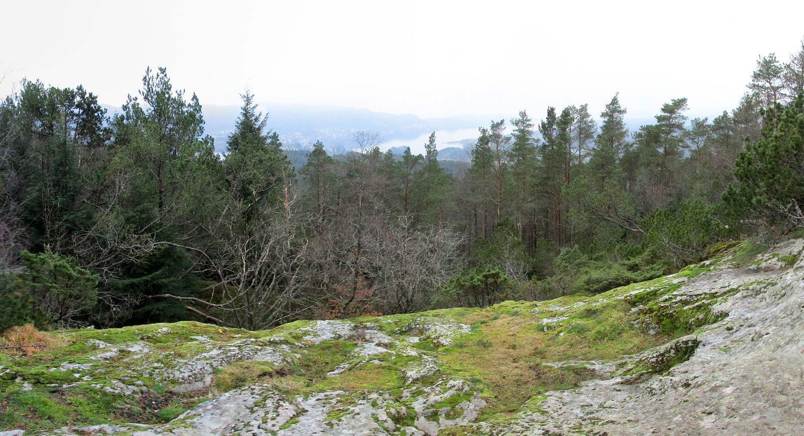
Bogafjellet from Reinsvegen
- Date:
- 18.11.2018
- Characteristic:
- Hillwalk
- Duration:
- 3:45h
- Distance:
- 11.3km
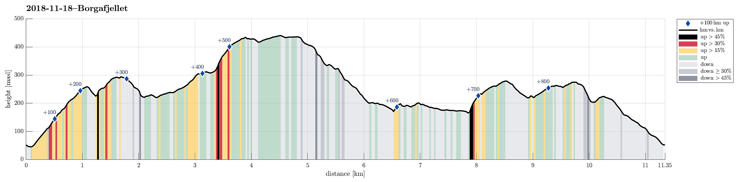 Even though the weather, with very low hanging clouds, did not look all to promising for a hike somewhere higher up, I still decided to give it a try and headed south and towards Fusa (via Osøyro, then taking the ferry from Hatvik to Senjaneset). Even on the ferry across Fusafjorden I wondered, whether it was that good an idea at all (the impression which the sun made, breaking through the low-hanging clouds, however, was definitely worth the view!). After arriving in Fusa, I quickly turned right from the main road and followed road 122 towards Strandvik (via Vinnes). Before actually getting to the "center" of Strandvik, I turned left and headed towards Reinsvegen. Passing by Kvåle, I drove up the valley until a spot near Snøhaugen. From there, I had planned to hike a round >>>
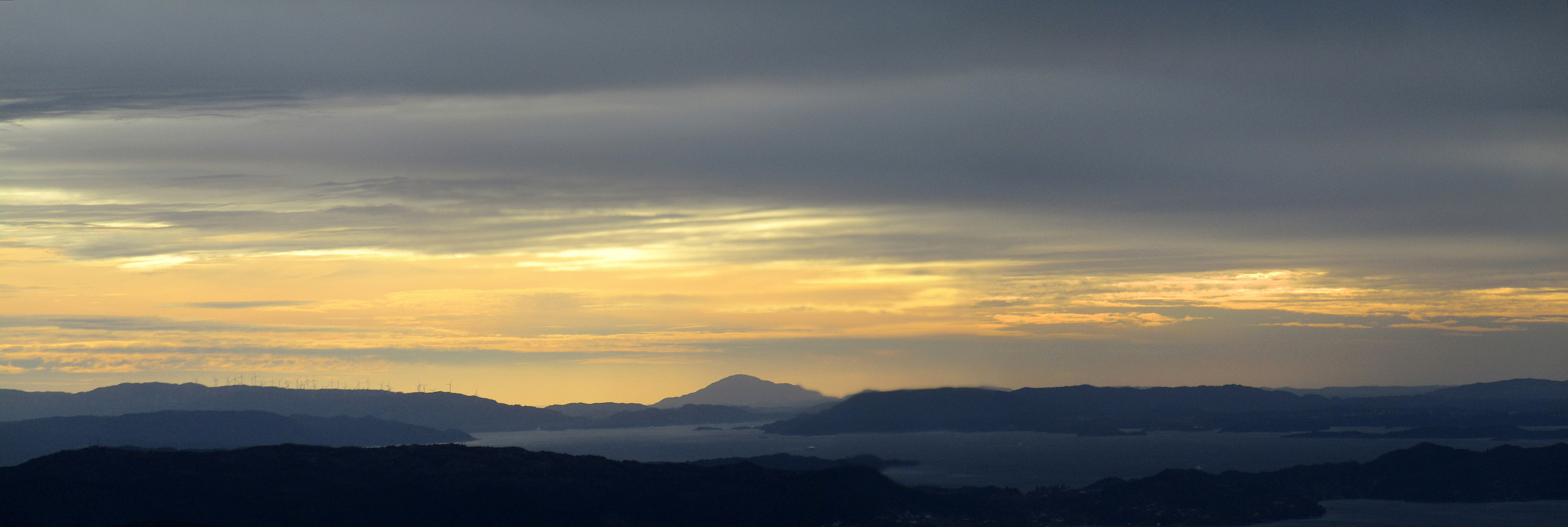
Stendafjellet at about sunset
- Date:
- 17.11.2018
- Characteristic:
- Hillwalk
- Duration:
- 1:00h
- Distance:
- 3.4km
 Even though it was already a bit late (for November in Bergen), there still was a chance for a short hike. From the little parking place near the previous train station at Stend (a bit north of Fana), I headed directly into the forest (in northern direction), not following the gravel road that also starts from there (a bit further east). After only a few steps, I got to a little pond (seemingly hold back by a little dam) and chose to surround it on its western side. In order to get further up, I crossed a little saddle north of the pond and ascended through the forest in northeastern direction, following one of apparently several possible routes. Once a bit further up, the terrain flattened out (a bit) and I continued in northern direction, heading towards Stendaåsen. After reaching the >>>
Løvstakken for some fresh air
- Date:
- 04.11.2018
- Characteristic:
- Hillwalk
- Duration:
- 1:00h
- Distance:
- 3.1km
 Due to a lack of more time, we this time "only" made a quick hike up Løvstakken. We parked right next to Litlavatnet in Fyllingsdalen and ascended via the main path to Løvstakken from there (first towards Ravnefjellet, then around and up to Løvstakken). After a short stop at the top (in strong winds!), we returned along the same path. Always good to at least get a bit of fresh air! :-)
Selected photos are available as Google photo album .
See also the related FB-page Hiking around Bergen, Norway .
Web page WestCoastPeaks.com provides useful information about Løvstakken .
Due to a lack of more time, we this time "only" made a quick hike up Løvstakken. We parked right next to Litlavatnet in Fyllingsdalen and ascended via the main path to Løvstakken from there (first towards Ravnefjellet, then around and up to Løvstakken). After a short stop at the top (in strong winds!), we returned along the same path. Always good to at least get a bit of fresh air! :-)
Selected photos are available as Google photo album .
See also the related FB-page Hiking around Bergen, Norway .
Web page WestCoastPeaks.com provides useful information about Løvstakken .
Sæterfjellet on a wonderful winter day
- Date:
- 28.10.2018
- Characteristic:
- Hillwalk
- Duration:
- 7:00h
- Distance:
- 14.7km
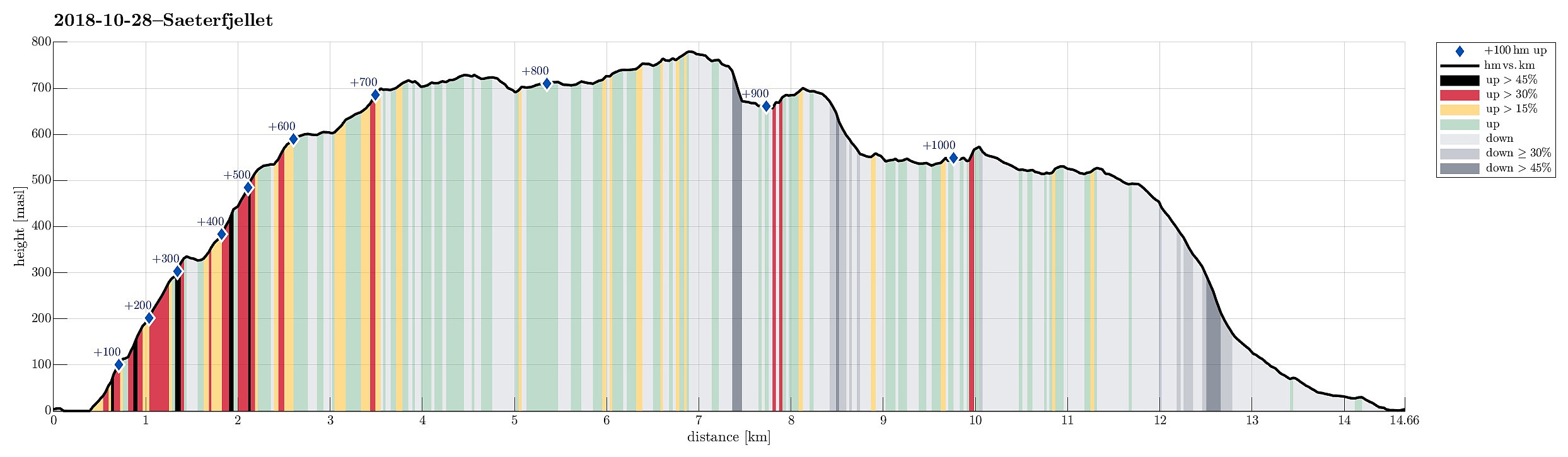 We drove from Bergen northwards on E39, continuing further in the direction of Førde after Knarvik. Right before entering Eikefettunnelen, we left E39 and continued on road 570 in northern direction. After coming by Dyrdalen, we soon reached Kjekallevågen and bridge over it. Right afterwards, on Borgaholmane, we parked and started our hike.
To start, we first crossed the bridge again (now per pedes and in southern direction) and headed towards Langeneset. At exactly the point, where the bridge ends, we left the road and started our ascent to Såta, stepping up a long ridge (south of Rasmusdalen), leading up to Gamlesetra, etc. The first check-point along this route is a point at about 115mosl, where the power line, which comes southwards across Kjekallevågen, makes a turn so that it >>>
We drove from Bergen northwards on E39, continuing further in the direction of Førde after Knarvik. Right before entering Eikefettunnelen, we left E39 and continued on road 570 in northern direction. After coming by Dyrdalen, we soon reached Kjekallevågen and bridge over it. Right afterwards, on Borgaholmane, we parked and started our hike.
To start, we first crossed the bridge again (now per pedes and in southern direction) and headed towards Langeneset. At exactly the point, where the bridge ends, we left the road and started our ascent to Såta, stepping up a long ridge (south of Rasmusdalen), leading up to Gamlesetra, etc. The first check-point along this route is a point at about 115mosl, where the power line, which comes southwards across Kjekallevågen, makes a turn so that it >>>
Rispingen on a beautiful day!
- Date:
- 27.10.2018
- Characteristic:
- Hillwalk
- Duration:
- 3:30h
- Distance:
- 11.2km
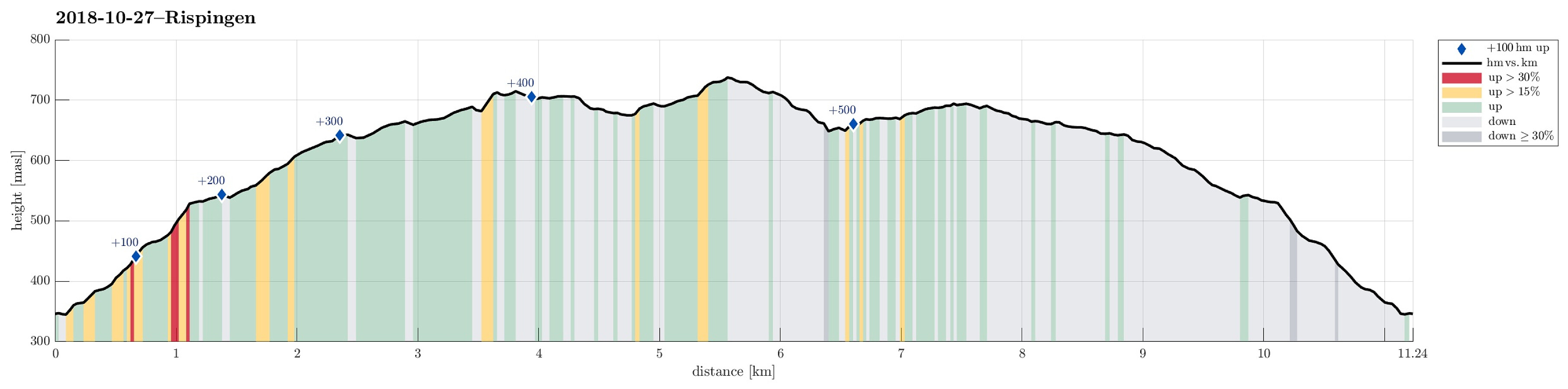 We took the car from Bergen to Osterøy (via the bridge east of Arna) and continued then further to Bruvik along Sørfjorden, before we eventually drove up northwards (between Brøknipa and Olsnesnipa) through Bjørndalen until we parked at the large parking spot at Båtaleitet (about 350mosl). From there, we hiked along the path which leads up to Skarvenipa via Flærne (on the west of Øvstebotnen). We then continued (still on the path) towards Rispingen, coming close to Raudskredbruna. Instead of continuing on the path (directly to Rispingen), we circled Raudskredtjørna on its northeast and ascended the short stretch to Raudskredbruna, enjoying some nice views from up there. From there, we decided to head back to the path (instead of descending further down towards Stemmetjørna) and >>>
Loddo and Skaftafjellet
- Date:
- 06.10.2018
- Characteristic:
- Hillwalk
- Duration:
- 4:30h
- Distance:
- 15.2km
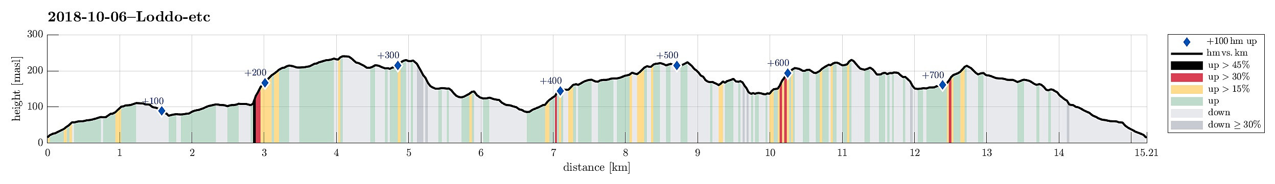 We took the ferry from Krokeide to Hufthammar and drove than along Huftarøy (road 154). Right next to Åkyllaren, there is a well-marked parking place for those, who wish to hike up to Loddo. We followed the main track (in southeastern direction) until we found a sign leading us on a separate track, heading north. Later, it turned out that we had left the main track too early and thus were a little bit too far west (as compared to the "red" track up to Loddo). Near Hestatjørna, we also managed to misinterpret another sign, which would have lead us back to the "red" track and up to Loddo. Instead, we followed the path further north, wondering more and more, where we had ended up! :-) After a while, we found another sign, which promised us a connection to the "blue" >>>
Nonkletten, Sørkletten, and Klubben
- Date:
- 05.10.2018
- Characteristic:
- Hillwalk
- Duration:
- 3:00h
- Distance:
- 8.4km
 After a nice meeting in Fotlandsvåg, I wanted to use the afternoon to do a little hike nearby. Looking at the map, I got interested in a round near Kleppsvatnet, including Nonkletten, Sørkletten, and Klubben. I drove across Kleppsskaret and down to Kleppsvatnet (its southern end) and parked right next to the southernmost end of the lake.
From there, I headed into the direction of Nonkletten, parallel to the lake. The first (short) stretch was still a forest road, leading up to a small saddle. On the other, northern side, the road turned more and more into water until it got completely exchanged for a little stream, coming down from the northeast (and heading towards Kleppsvatnet). I first followed the stream upwards through the forest, before I decided to aim at a higher route towards >>>
After a nice meeting in Fotlandsvåg, I wanted to use the afternoon to do a little hike nearby. Looking at the map, I got interested in a round near Kleppsvatnet, including Nonkletten, Sørkletten, and Klubben. I drove across Kleppsskaret and down to Kleppsvatnet (its southern end) and parked right next to the southernmost end of the lake.
From there, I headed into the direction of Nonkletten, parallel to the lake. The first (short) stretch was still a forest road, leading up to a small saddle. On the other, northern side, the road turned more and more into water until it got completely exchanged for a little stream, coming down from the northeast (and heading towards Kleppsvatnet). I first followed the stream upwards through the forest, before I decided to aim at a higher route towards >>>
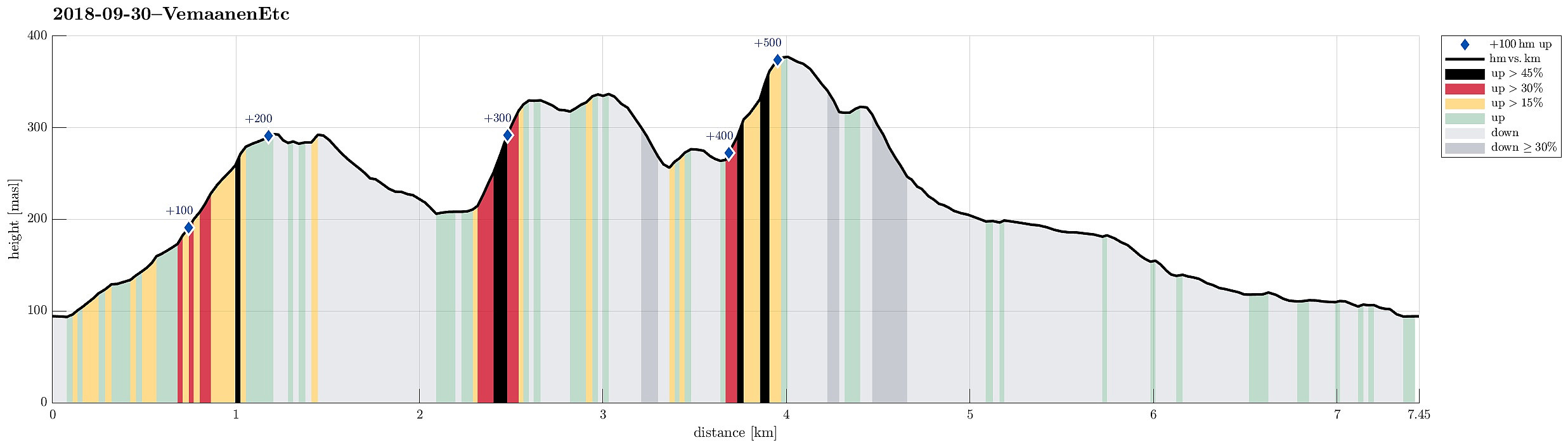
Vemånen, Hovden, etc.
- Date:
- 30.09.2018
- Characteristic:
- Hillwalk
- Duration:
- 2:30h
- Distance:
- 7.4km
 On this day with a "mixed" weather prediction, we decided to do a smaller hike, still trying something new. We parked near the Unneland Kultur og Aktivitetshus at Unnelandsvegen 253, 5268 Haukeland, and walked from there.
Immediately after crossing the bridge over the stream that comes down from Seterdalen (as well as from Rambjørgsgjelet), heading towards Haukelandsvatnet (at Nesvika), we found the path to Vemånen (first passing by Rodalshaugen). This is a very easy to find and nice to walk path, following the ridge (mostly in northern direction) up to Vemånen. Near the top of Vemånen, one gets out of the forest and can enjoy some nice views, in particular over Haukeland and Haukelandsvatnet. The best viewpoint, however, is not at the "top" of Vemånen, but a few >>>
On this day with a "mixed" weather prediction, we decided to do a smaller hike, still trying something new. We parked near the Unneland Kultur og Aktivitetshus at Unnelandsvegen 253, 5268 Haukeland, and walked from there.
Immediately after crossing the bridge over the stream that comes down from Seterdalen (as well as from Rambjørgsgjelet), heading towards Haukelandsvatnet (at Nesvika), we found the path to Vemånen (first passing by Rodalshaugen). This is a very easy to find and nice to walk path, following the ridge (mostly in northern direction) up to Vemånen. Near the top of Vemånen, one gets out of the forest and can enjoy some nice views, in particular over Haukeland and Haukelandsvatnet. The best viewpoint, however, is not at the "top" of Vemånen, but a few >>>
Algrøyna, Barmaneset, Langtrotten -- wow!
- Date:
- 23.09.2018
- Characteristic:
- Hike
- Duration:
- 3:30h
- Distance:
- 6.4km
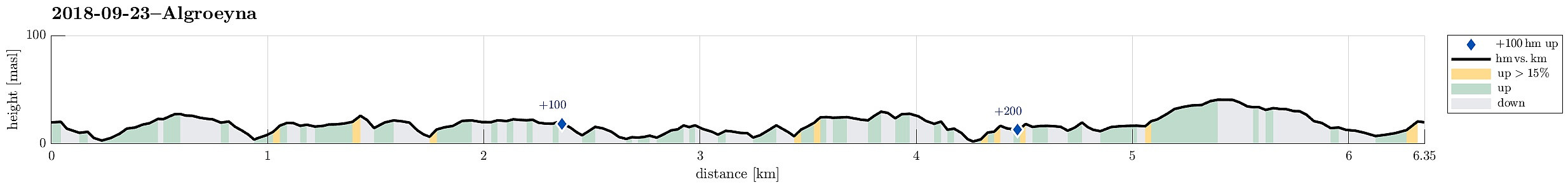 We parked the cars just before entering the main village on Algrøyna and started to hike from there. It had just poored down substantially, but as we started hiking the weather improved and soon we saw some sun, also! :-) We first followed the "main road", Nordre Øyavegen, in a longer swing to the right/north, before turning left, continuing on Kongvikvegen. Before the end of this road and about where Kungvika has its western-most point, we left the road, walking around a farm house right next to the road, in order to connect to the southern side of Kungvika (and eventually to Barmaneset). Once on the "middle" peninsula of Algrøyna, we followed a path with blue marks towards the west. This path leads out on Barmaneset and to Krabbakeila at its western end. Enjoying >>>
Hiking the southern part of Strøno
- Date:
- 08.09.2018
- Characteristic:
- Hike
- Duration:
- 2:30h
- Distance:
- 6.1km
 There was not really time for a longer hike and also it was expected that some rather heavy rain may come in the early evening. Therefore, we decided to do something smaller, i.e., a hike over Strøno south of Bergen (and west of Osøyro). We passed Fanafjellet with our car and turned right (westwards) at the military camp at Ulven. Following the street, we soon crossed over the bridge at Hillershavn to Strøno. Once on Strøno, we followed the southern street to Sørstrøno. From there, we started hiking, first following a major gravel road which passes by Strønevågen and Selvågspollen (in their northwest).
Our first goal was Husfjellet, a little hill that stands a bit for its own in the very south of Strøno. We first continued on the gravel road, making a half-circle around the hill >>>
There was not really time for a longer hike and also it was expected that some rather heavy rain may come in the early evening. Therefore, we decided to do something smaller, i.e., a hike over Strøno south of Bergen (and west of Osøyro). We passed Fanafjellet with our car and turned right (westwards) at the military camp at Ulven. Following the street, we soon crossed over the bridge at Hillershavn to Strøno. Once on Strøno, we followed the southern street to Sørstrøno. From there, we started hiking, first following a major gravel road which passes by Strønevågen and Selvågspollen (in their northwest).
Our first goal was Husfjellet, a little hill that stands a bit for its own in the very south of Strøno. We first continued on the gravel road, making a half-circle around the hill >>>
