Archive - Date
Archive - Activity
-
Bike trip (137)
- Bike trip - mixed (51)
- Bike trip - road (9)
-
Other trip (1)
- Kayaking (1)
-
Other winter trip (4)
- Snowshoe trip (4)
- Ski trip (4)
- Trip by foot (740)
Archive - Geography
Peakbook-Friends


Collected lists
-
Bergen ≥ 50m pf. og ≥ 100 m.o.h.
(87/89)
 97%
97% -
Most dominating tops of the Bergen peninsula
(68/75)
90%
-
Utvalgte topper og turmål i Bergen
(316/350)
90%
-
Alle topper i Bergen
(357/398)
89%
-
Opptur Bergen
(100/113)
88%
-
De syv fjell rundt Bergen
(6/7)
85%
-
Sund ≥ 50m pf.
(14/18)
77%
-
Os ≥ 50m pf.
(25/34)
73%
-
Søyler (fastmerker) i Bergen
(68/100)
68%
-
Fjell ≥ 50m pf.
(21/32)
65%

Short walk to Donaghys Hill
- Date:
- 05.11.2023
- Characteristic:
- Hillwalk
- Duration:
- 1:00h
- Distance:
- 2.2km
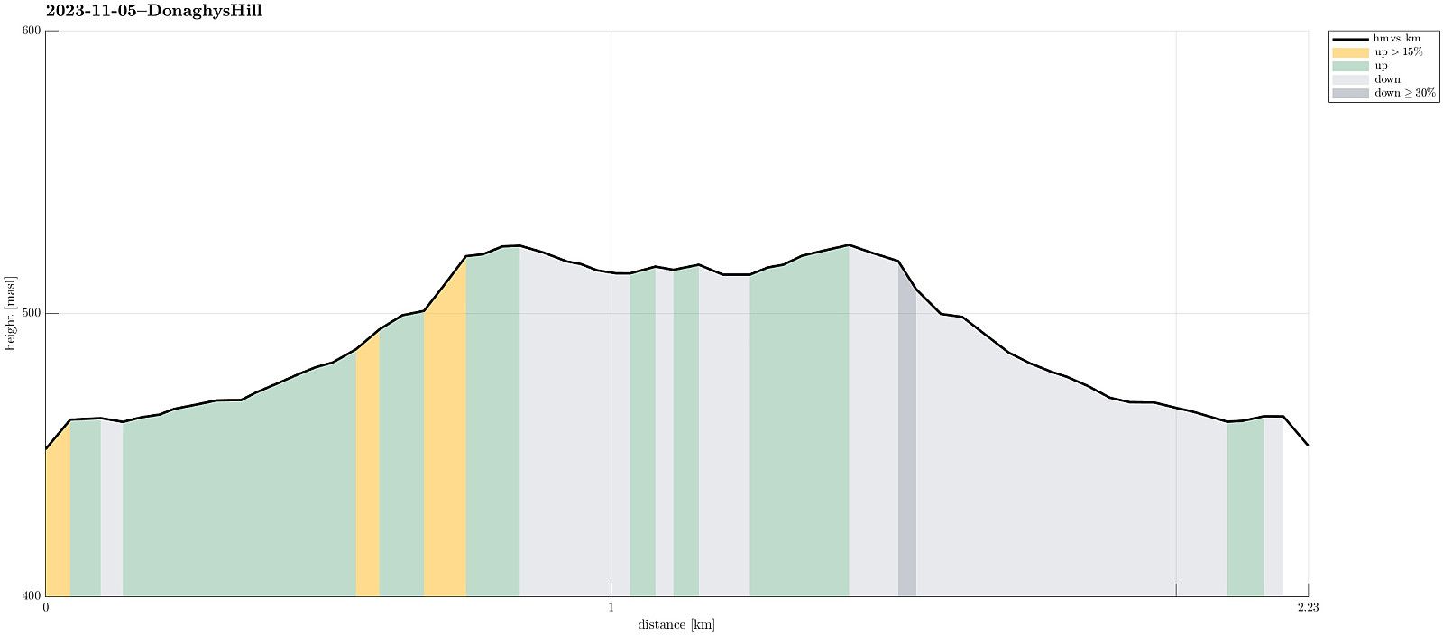 While we thought that we not really had sufficient time for an extended hike, this day, we still wished to see at least something along our drive through the Central Highlands. To do so, we followed a sign that suggested a short walk to Donaghys Hill in order to appreciate some nice views from its top. Parking right next to the highway, we first walked along a forest road, before turning right and into the forest along a regular trail. Not for the first time, and not for the last time in Tasmania, neither, we got very impressed by the very tall trees (and the jungle underneath them). Not far along this trail, we then stepped out of the forest and up onto Donaghys Hill. And indeed, it is true that this little hill offers surprisingly nice views, to the far (for ex., to Frenchmans Cap) as >>>
Visiting Whisky Bay
- Date:
- 28.10.2023
- Characteristic:
- Hillwalk
- Duration:
- 1:00h
- Distance:
- 1.8km
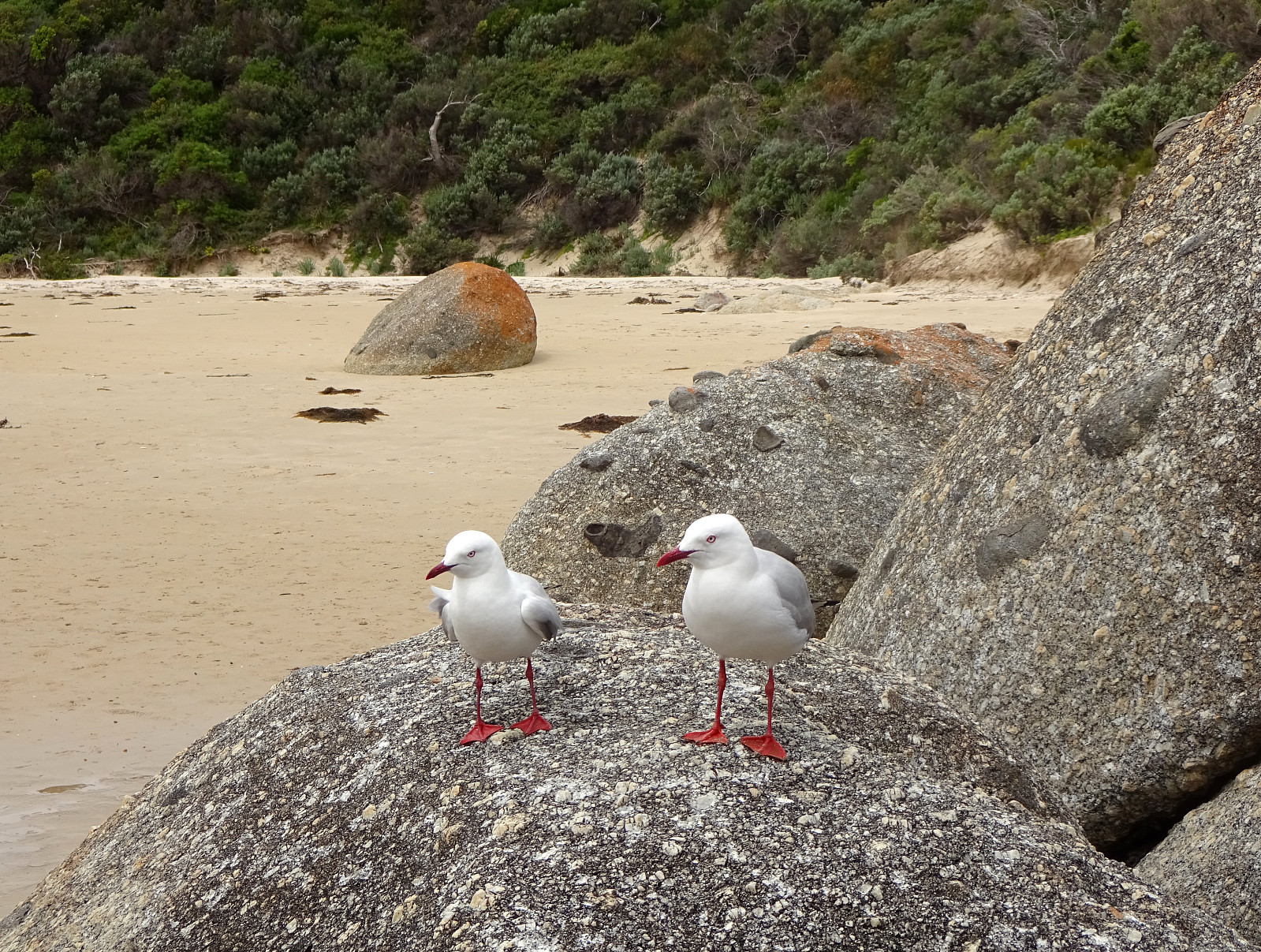 Our third stop in Wilsons Prom (Wilsons Promonotory) was to visit Whisky Bay. We started at the Picnic Bay Carpark, walking down to the Picnic Bay and Whisky Bay Lookout, first. We then continued to Whisky Bay, which impresses with its colored rocks and a nice beach! :-)
Selected photos are available as Google photo album .
See also the related FB-page Hiking around Bergen, Norway .
Our third stop in Wilsons Prom (Wilsons Promonotory) was to visit Whisky Bay. We started at the Picnic Bay Carpark, walking down to the Picnic Bay and Whisky Bay Lookout, first. We then continued to Whisky Bay, which impresses with its colored rocks and a nice beach! :-)
Selected photos are available as Google photo album .
See also the related FB-page Hiking around Bergen, Norway .
Exploring the Dunes of the Big Drift
- Date:
- 28.10.2023
- Characteristic:
- Hillwalk
- Duration:
- 2:00h
- Distance:
- 6.7km
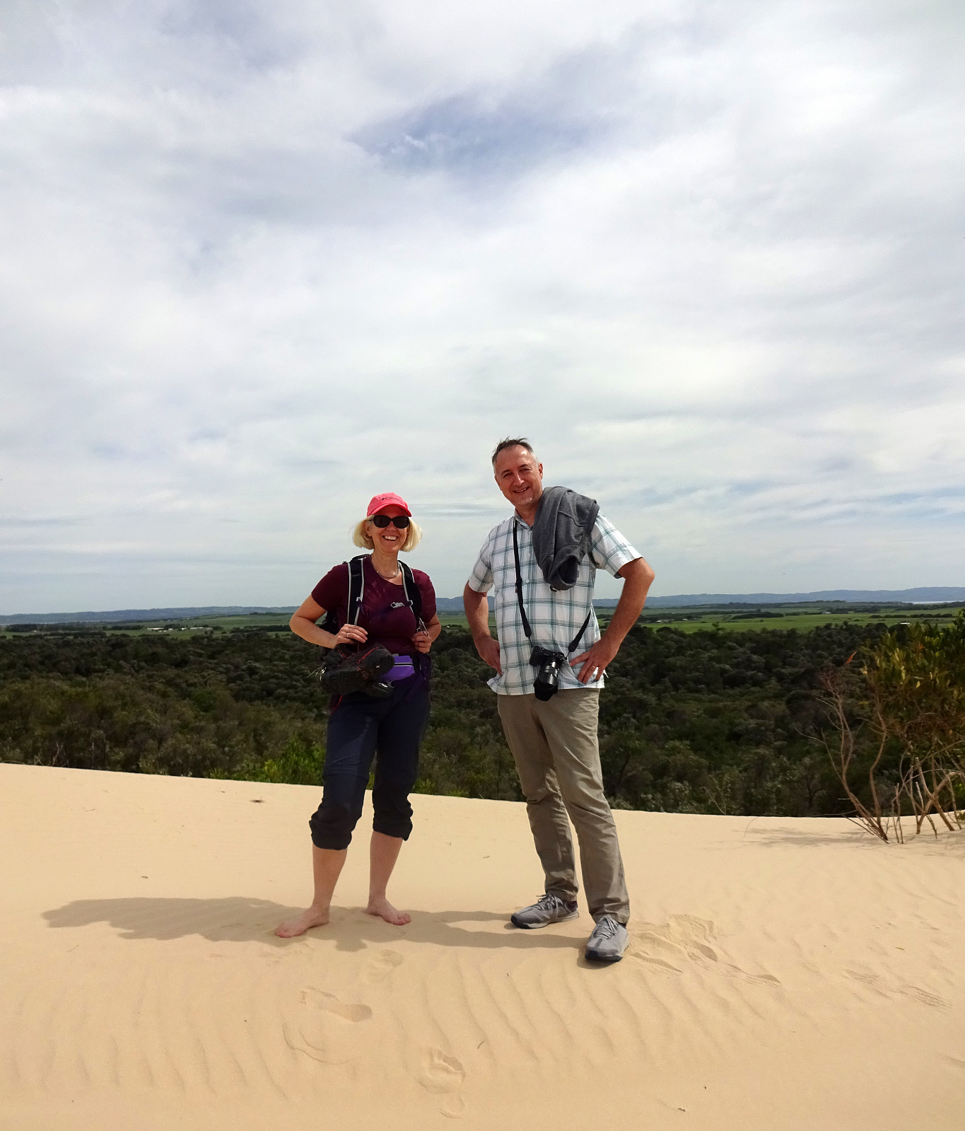 After rounding off the conference in Melbourne, we were ready to explore Victoria a bit. Our first target was Wilsons Prom (Wilsons Promontory) in the southeast of Melbourne. Before driving "all the way" into Wilsons Prom, we started with an exploration of the Dunes of the Big Drift. Following a well-marked trail from the road, we easily connected to the dunes. All this rather large area of sand dunes, surrounded by green nature (and the sea in the west), is a bit surreal and really an interesting spot to visit. Definitely worth the short walk! :-)
Selected photos are available as Google photo album .
See also the related FB-page Hiking around Bergen, Norway .
After rounding off the conference in Melbourne, we were ready to explore Victoria a bit. Our first target was Wilsons Prom (Wilsons Promontory) in the southeast of Melbourne. Before driving "all the way" into Wilsons Prom, we started with an exploration of the Dunes of the Big Drift. Following a well-marked trail from the road, we easily connected to the dunes. All this rather large area of sand dunes, surrounded by green nature (and the sea in the west), is a bit surreal and really an interesting spot to visit. Definitely worth the short walk! :-)
Selected photos are available as Google photo album .
See also the related FB-page Hiking around Bergen, Norway .
Saturday walk to Knappen
- Date:
- 07.10.2023
- Characteristic:
- Hillwalk
- Duration:
- 1:00h
- Distance:
- 4.8km
 One of our afternoon walks to Knappen, enjoying some nice weekend weather. While we stepped up along one of our more usual routes (via Sandeidbrotet, continuing to Knappen via Eldtona), we chose a partially off-trail route down to Knappenveien. Good to get a bit of fresh air! :-)
See also the related FB-page Hiking around Bergen, Norway .
Petter Bjørstad has a useful page about Knappen .
Web page UT.no from the Norwegian Trekking Association recommends another hike to Knappen .
One of our afternoon walks to Knappen, enjoying some nice weekend weather. While we stepped up along one of our more usual routes (via Sandeidbrotet, continuing to Knappen via Eldtona), we chose a partially off-trail route down to Knappenveien. Good to get a bit of fresh air! :-)
See also the related FB-page Hiking around Bergen, Norway .
Petter Bjørstad has a useful page about Knappen .
Web page UT.no from the Norwegian Trekking Association recommends another hike to Knappen .
Short excursion to Sælenvatnet
- Date:
- 23.10.2021
- Characteristic:
- Hillwalk
- Duration:
- 0:30h
- Distance:
- 2.1km
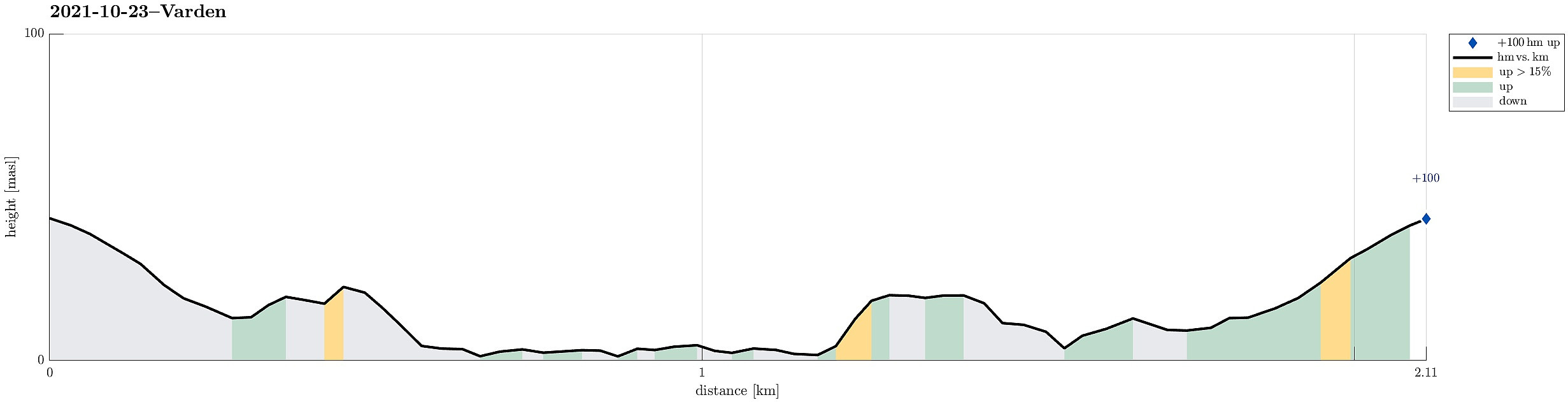 Very shot excursion to the local peninsula in Sælenvatnet to get some fresh air.
See also the related FB-page Hiking around Bergen, Norway .
Very shot excursion to the local peninsula in Sælenvatnet to get some fresh air.
See also the related FB-page Hiking around Bergen, Norway .
Crossing Gullsteinen to Fyllingsdalen
- Date:
- 13.10.2021
- Characteristic:
- Hillwalk
- Duration:
- 2:00h
- Distance:
- 8.5km
 After dropping off my bike for a service I head back to Fyllingsdalen. After crossing Fjøsangerveien near the near tunnel portal (for Bybanen and cyclists), I walked up Grønestølsveien to find a way into the green above the houses. After getting to Grønnestølslien, I could not see an immediate opportunity to continue further up. Accordingly, I first followed Grønnestølslien in southern direction until it ends near a littl stream that is coming down from Løvstakken there. There, I connected to a proper trail that leads upwards; first on the eastern side of the stream. At about 160mosl, I crossed the stream and continued further upwards in western direction. After crossing over an old stone wall, I arrived at a somewhat flat spot at about 250mosl. From there, I continued further >>>
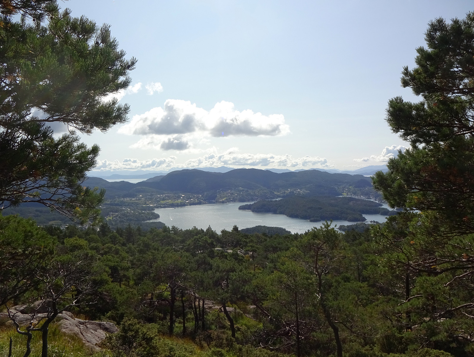
Vassenden and Store Kongshaugen
- Date:
- 25.09.2021
- Characteristic:
- Hillwalk
- Duration:
- 3:15h
- Distance:
- 8.9km
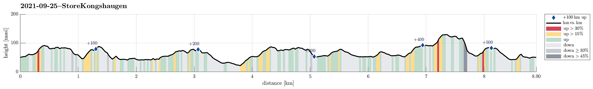 I needed some fresh air and thus decided to make a short hike through the forest in the north of Store Kongshaugen. To get there, I cycled first into the direction of Haakonsvern, before turning to the right and onto Vassendveien (near the entry to the military area at Haakonsvern). Right below Ørnahaugen, I left my bike behind and started my little forest hike. I first walked in northern direction (not directly towards Vassenden though) and found a nice trail which then brought me up to Grønabrekka. Grønabrekka has some steep sides towards the west, making it really nice to traverse it along its south-north top line. After walking over all of it, I found myself not far from Høghaugen (and not far from Storavatnet, neither). I included Høghaugen via a little loop, before heading >>>
Tverrfjellet
- Date:
- 21.08.2021
- Characteristic:
- Hillwalk
- Duration:
- 1:30h
- Distance:
- 2.9km
 With just a little bit of time available, we simply headed for a short exploration of the forest north of Nordvik (south of Fanafjellet). After driving over Fanafjellet from Bergen, we parked along road 5158 just northeast of Nordvik. From there, we proceeded right into the forest (in western direction), coming by Klubnehaugen in its north only a short while later, before entering the valley of Moldstigen north of Nordvik. Instead of following the main trail up this valley, we ascended into the direction of Tverrfjellet, leaving the valley in western direction. After a bit of an ascent through the forest, we arrived first at a smaller side-top of Tverrfjellet in its southeast. Even though we already had some nice views from there (between the trees), we still made it across a little wet >>>
Urdanipa
- Date:
- 13.07.2021
- Characteristic:
- Hillwalk
- Duration:
- 0:30h
- Distance:
- 1.8km
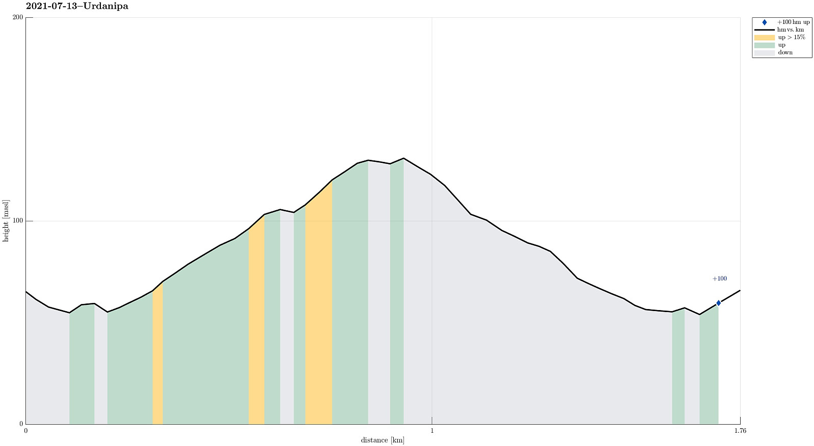 After our longer hike on Ytre Sula , we still had some appetite and thus decided to pay the north of Sula a short evening visit. Driving eastwards on road 606, passing by Hardbakke along the way, we surrounded Pollatinden and then Hagefjorden (both in their south), before coming close to Ulvegreina. North of that mountain, we then left road 606, turning left (into northern direction, towards Hersvikbygda and Leknessundet). While briefly considering to make a quick hike up to Husefjellet (in the southeast of Hersvikbygda), we then decided to "just" do Urdanipa (south of Leknessundet). The road towards Leknessundet gets actually quite near to Urdanipa, passing over a small saddle in the west of this little top. Finding a suitable place for parking the car, however, is not 100% easy as the road is very >>>
Exploring Knappen near Kallestad
- Date:
- 04.07.2021
- Characteristic:
- Hillwalk
- Duration:
- 4:00h
- Distance:
- 6.7km
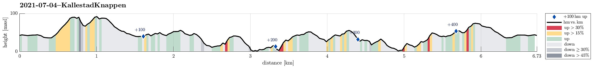 The plan was to use a nice, warm summer day and hike into the north of Kallestad. We parked next to Grendahuset in Kallestad and first walked the street back northwards until we came to Sjoartjørna. Where Kallestadvikvegen turns around this little lake (in its west), a trail heads off in northwestern direction. After only a few meters, already, one has the choice between going directly to Storhaugen, or ascending to Austre Storhaugen, first. We did the latter, heading up to Austre Storhaugen, first, enjoying some nice views, including one back down to Sjoartjørna. From Austre Storhaugen, one can then connect to Storhaugen via a steep descent, first, and then joining the trail that comes around Austre Storhaugen in its south. From Vestre Storhaugen, just a few meters in the west of Storhaugen, >>>
