Archive - Date
Archive - Activity
-
Bike trip (137)
- Bike trip - mixed (51)
- Bike trip - road (9)
-
Other trip (1)
- Kayaking (1)
-
Other winter trip (4)
- Snowshoe trip (4)
- Ski trip (4)
- Trip by foot (740)
Archive - Geography
Peakbook-Friends


Collected lists
-
Bergen ≥ 50m pf. og ≥ 100 m.o.h.
(87/89)
 97%
97% -
Most dominating tops of the Bergen peninsula
(68/75)
90%
-
Utvalgte topper og turmål i Bergen
(316/350)
90%
-
Alle topper i Bergen
(357/398)
89%
-
Opptur Bergen
(100/113)
88%
-
De syv fjell rundt Bergen
(6/7)
85%
-
Sund ≥ 50m pf.
(14/18)
77%
-
Os ≥ 50m pf.
(25/34)
73%
-
Søyler (fastmerker) i Bergen
(68/100)
68%
-
Fjell ≥ 50m pf.
(21/32)
65%

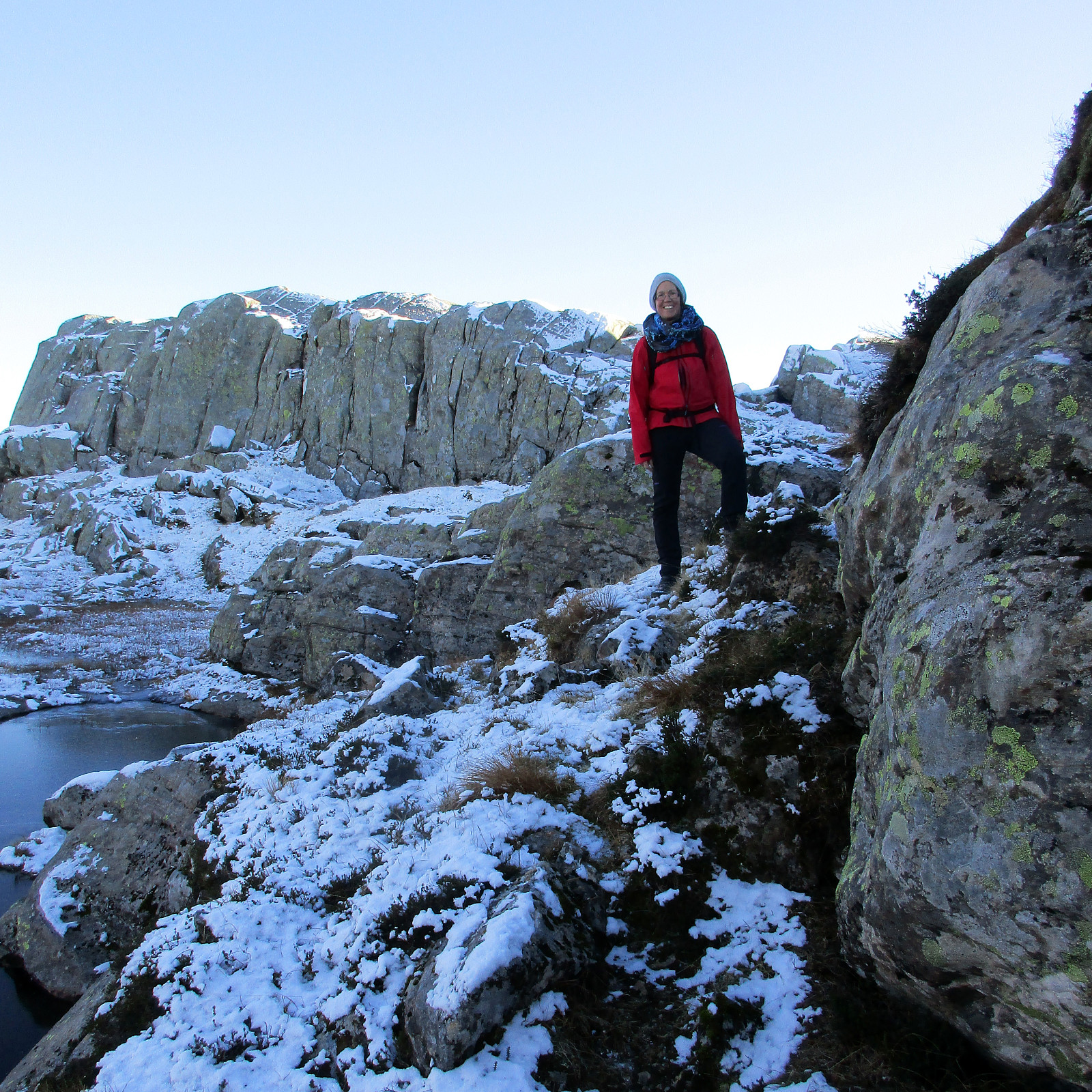
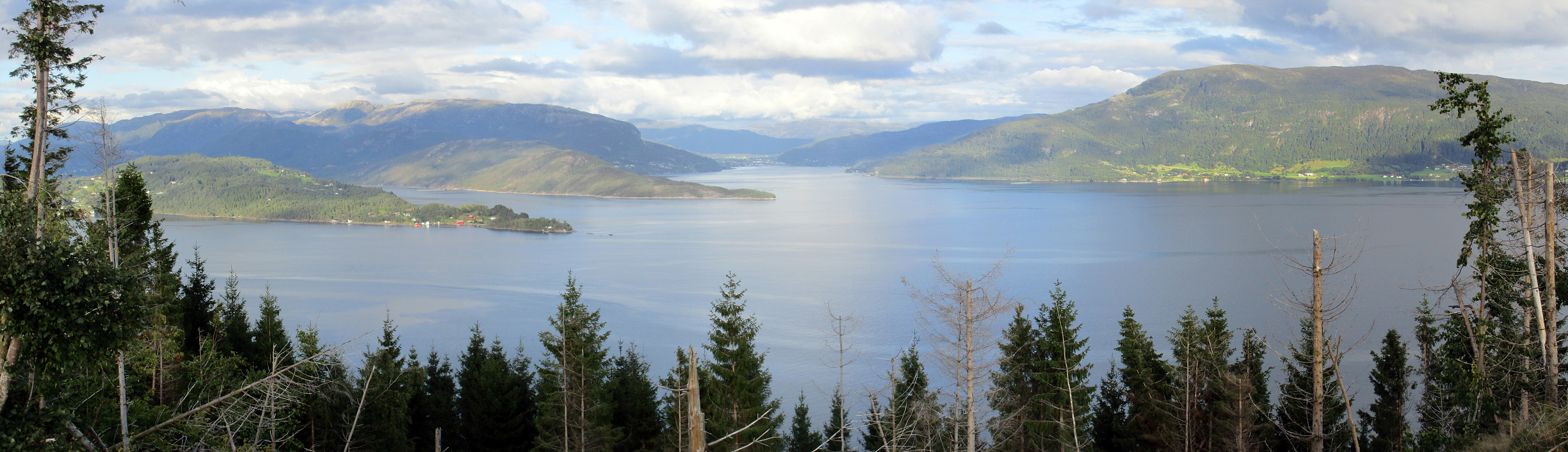
Sæterfjellet on a wonderful winter day
- Date:
- 28.10.2018
- Characteristic:
- Hillwalk
- Duration:
- 7:00h
- Distance:
- 14.7km
 We drove from Bergen northwards on E39, continuing further in the direction of Førde after Knarvik. Right before entering Eikefettunnelen, we left E39 and continued on road 570 in northern direction. After coming by Dyrdalen, we soon reached Kjekallevågen and bridge over it. Right afterwards, on Borgaholmane, we parked and started our hike.
To start, we first crossed the bridge again (now per pedes and in southern direction) and headed towards Langeneset. At exactly the point, where the bridge ends, we left the road and started our ascent to Såta, stepping up a long ridge (south of Rasmusdalen), leading up to Gamlesetra, etc. The first check-point along this route is a point at about 115mosl, where the power line, which comes southwards across Kjekallevågen, makes a turn so that it >>>
We drove from Bergen northwards on E39, continuing further in the direction of Førde after Knarvik. Right before entering Eikefettunnelen, we left E39 and continued on road 570 in northern direction. After coming by Dyrdalen, we soon reached Kjekallevågen and bridge over it. Right afterwards, on Borgaholmane, we parked and started our hike.
To start, we first crossed the bridge again (now per pedes and in southern direction) and headed towards Langeneset. At exactly the point, where the bridge ends, we left the road and started our ascent to Såta, stepping up a long ridge (south of Rasmusdalen), leading up to Gamlesetra, etc. The first check-point along this route is a point at about 115mosl, where the power line, which comes southwards across Kjekallevågen, makes a turn so that it >>>
Rispingen on a beautiful day!
- Date:
- 27.10.2018
- Characteristic:
- Hillwalk
- Duration:
- 3:30h
- Distance:
- 11.2km
 We took the car from Bergen to Osterøy (via the bridge east of Arna) and continued then further to Bruvik along Sørfjorden, before we eventually drove up northwards (between Brøknipa and Olsnesnipa) through Bjørndalen until we parked at the large parking spot at Båtaleitet (about 350mosl). From there, we hiked along the path which leads up to Skarvenipa via Flærne (on the west of Øvstebotnen). We then continued (still on the path) towards Rispingen, coming close to Raudskredbruna. Instead of continuing on the path (directly to Rispingen), we circled Raudskredtjørna on its northeast and ascended the short stretch to Raudskredbruna, enjoying some nice views from up there. From there, we decided to head back to the path (instead of descending further down towards Stemmetjørna) and >>>
Loddo and Skaftafjellet
- Date:
- 06.10.2018
- Characteristic:
- Hillwalk
- Duration:
- 4:30h
- Distance:
- 15.2km
 We took the ferry from Krokeide to Hufthammar and drove than along Huftarøy (road 154). Right next to Åkyllaren, there is a well-marked parking place for those, who wish to hike up to Loddo. We followed the main track (in southeastern direction) until we found a sign leading us on a separate track, heading north. Later, it turned out that we had left the main track too early and thus were a little bit too far west (as compared to the "red" track up to Loddo). Near Hestatjørna, we also managed to misinterpret another sign, which would have lead us back to the "red" track and up to Loddo. Instead, we followed the path further north, wondering more and more, where we had ended up! :-) After a while, we found another sign, which promised us a connection to the "blue" >>>
Nonkletten, Sørkletten, and Klubben
- Date:
- 05.10.2018
- Characteristic:
- Hillwalk
- Duration:
- 3:00h
- Distance:
- 8.4km
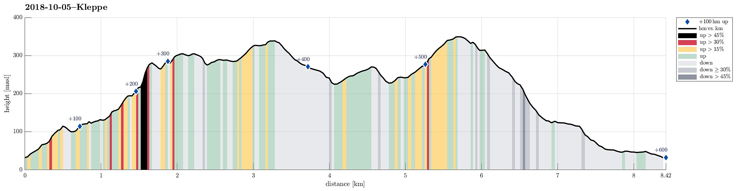 After a nice meeting in Fotlandsvåg, I wanted to use the afternoon to do a little hike nearby. Looking at the map, I got interested in a round near Kleppsvatnet, including Nonkletten, Sørkletten, and Klubben. I drove across Kleppsskaret and down to Kleppsvatnet (its southern end) and parked right next to the southernmost end of the lake.
From there, I headed into the direction of Nonkletten, parallel to the lake. The first (short) stretch was still a forest road, leading up to a small saddle. On the other, northern side, the road turned more and more into water until it got completely exchanged for a little stream, coming down from the northeast (and heading towards Kleppsvatnet). I first followed the stream upwards through the forest, before I decided to aim at a higher route towards >>>
After a nice meeting in Fotlandsvåg, I wanted to use the afternoon to do a little hike nearby. Looking at the map, I got interested in a round near Kleppsvatnet, including Nonkletten, Sørkletten, and Klubben. I drove across Kleppsskaret and down to Kleppsvatnet (its southern end) and parked right next to the southernmost end of the lake.
From there, I headed into the direction of Nonkletten, parallel to the lake. The first (short) stretch was still a forest road, leading up to a small saddle. On the other, northern side, the road turned more and more into water until it got completely exchanged for a little stream, coming down from the northeast (and heading towards Kleppsvatnet). I first followed the stream upwards through the forest, before I decided to aim at a higher route towards >>>
Vemånen, Hovden, etc.
- Date:
- 30.09.2018
- Characteristic:
- Hillwalk
- Duration:
- 2:30h
- Distance:
- 7.4km
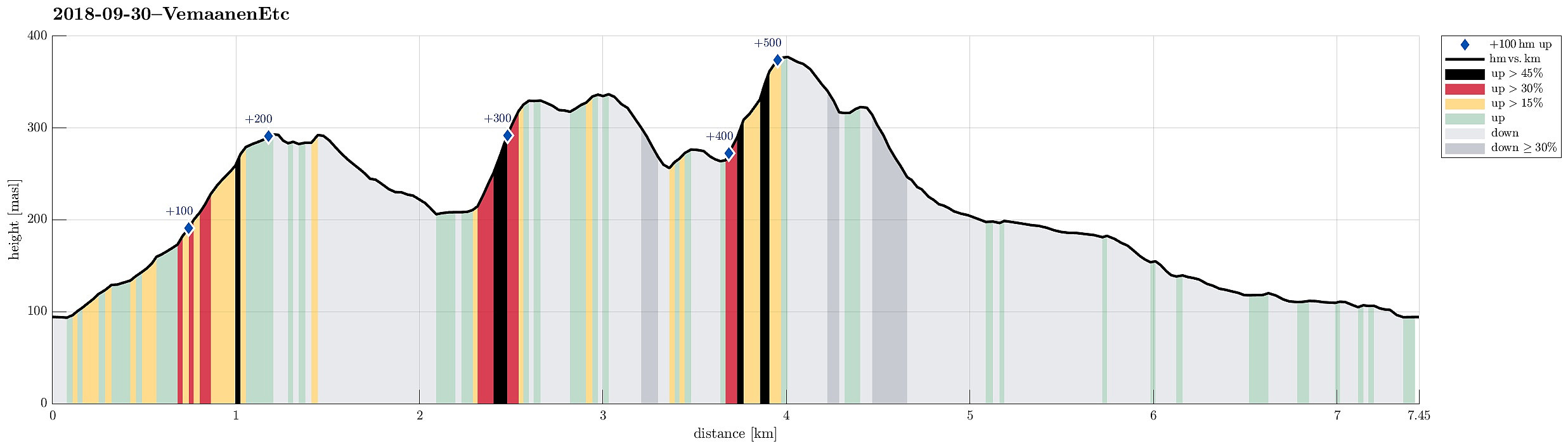 On this day with a "mixed" weather prediction, we decided to do a smaller hike, still trying something new. We parked near the Unneland Kultur og Aktivitetshus at Unnelandsvegen 253, 5268 Haukeland, and walked from there.
Immediately after crossing the bridge over the stream that comes down from Seterdalen (as well as from Rambjørgsgjelet), heading towards Haukelandsvatnet (at Nesvika), we found the path to Vemånen (first passing by Rodalshaugen). This is a very easy to find and nice to walk path, following the ridge (mostly in northern direction) up to Vemånen. Near the top of Vemånen, one gets out of the forest and can enjoy some nice views, in particular over Haukeland and Haukelandsvatnet. The best viewpoint, however, is not at the "top" of Vemånen, but a few >>>
On this day with a "mixed" weather prediction, we decided to do a smaller hike, still trying something new. We parked near the Unneland Kultur og Aktivitetshus at Unnelandsvegen 253, 5268 Haukeland, and walked from there.
Immediately after crossing the bridge over the stream that comes down from Seterdalen (as well as from Rambjørgsgjelet), heading towards Haukelandsvatnet (at Nesvika), we found the path to Vemånen (first passing by Rodalshaugen). This is a very easy to find and nice to walk path, following the ridge (mostly in northern direction) up to Vemånen. Near the top of Vemånen, one gets out of the forest and can enjoy some nice views, in particular over Haukeland and Haukelandsvatnet. The best viewpoint, however, is not at the "top" of Vemånen, but a few >>>
Via Purkedalsgjelet to Kofta etc.
- Date:
- 02.09.2018
- Characteristic:
- Hillwalk
- Duration:
- 7:45h
- Distance:
- 18.2km
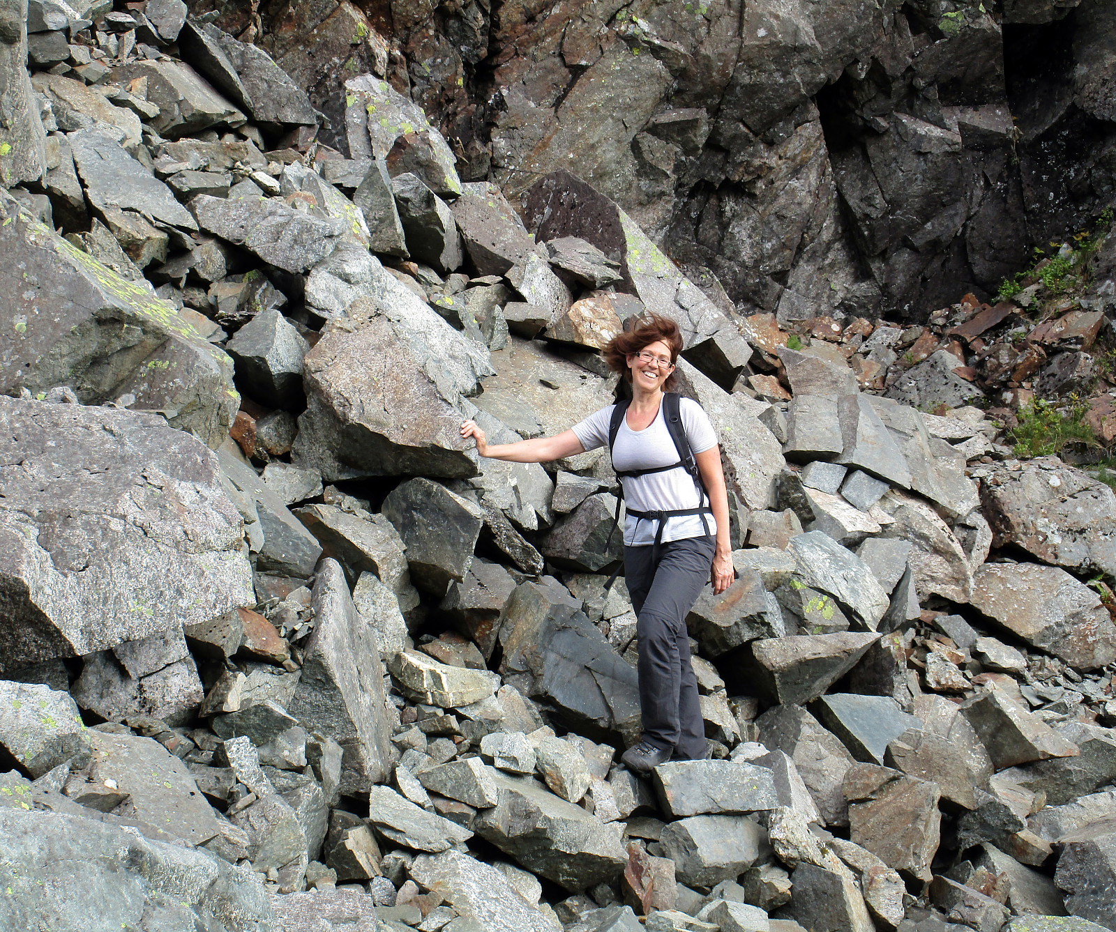 This hike, and in particular the part through Purkedalsgjelet up to Kofta, was one that asked for a careful preparation. It's recommended that you study the circumstances carefully and choose also the weather conditions appropriately. In order to enjoy this hike, you should (a) be at least somewhat experienced with hiking in the mountains around Bergen, in particular also without a path (finding your way, etc.) and (b) choose a dry day on which you can expect that there would not be too much water coming down Purkedalsgjelet (I'd rather not go this hike when snow is melting on Gullfjellet, or after some heavy rain). Take care (and enjoy)! :-)
We parked along the road from Os to Samnanger (#137), which passes Gullfjellet on its eastern (generally very steep) side. Actually, we first missed >>>
This hike, and in particular the part through Purkedalsgjelet up to Kofta, was one that asked for a careful preparation. It's recommended that you study the circumstances carefully and choose also the weather conditions appropriately. In order to enjoy this hike, you should (a) be at least somewhat experienced with hiking in the mountains around Bergen, in particular also without a path (finding your way, etc.) and (b) choose a dry day on which you can expect that there would not be too much water coming down Purkedalsgjelet (I'd rather not go this hike when snow is melting on Gullfjellet, or after some heavy rain). Take care (and enjoy)! :-)
We parked along the road from Os to Samnanger (#137), which passes Gullfjellet on its eastern (generally very steep) side. Actually, we first missed >>>
Rimstigfjellet via Rimstigen
- Date:
- 26.08.2018
- Characteristic:
- Hillwalk
- Duration:
- 6:00h
- Distance:
- 10.2km
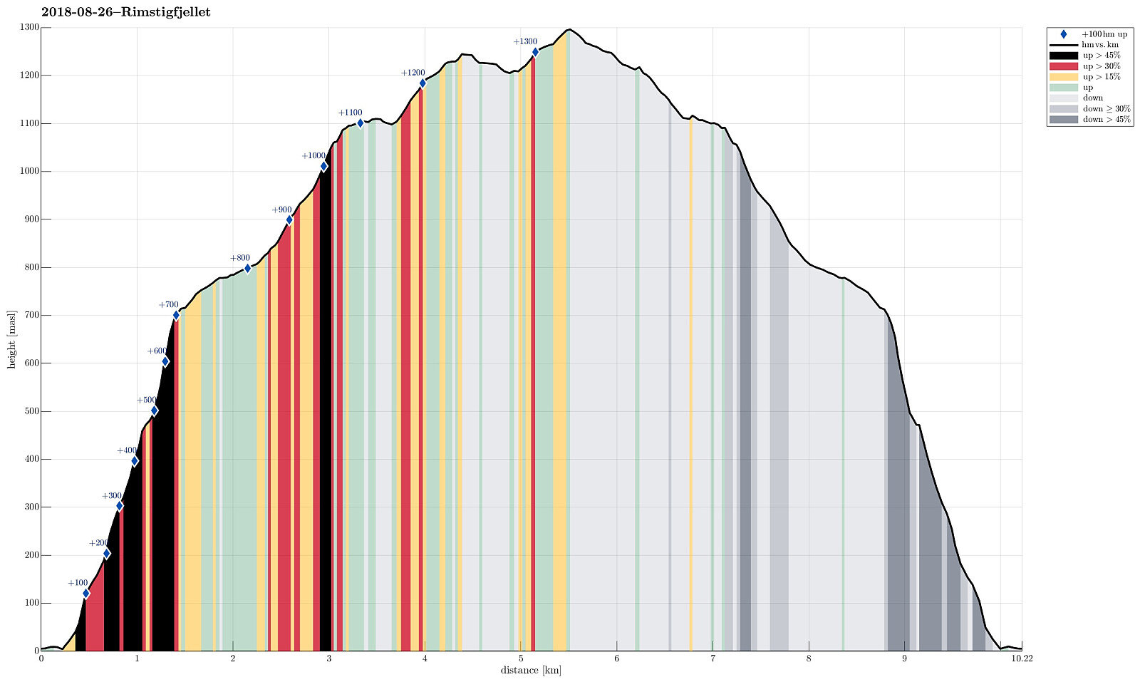 We took road E16 to Gudvangen first, before continuing from there towards Bakka on the western side of Nærøyfjorden. Only a short bit after Bakka, we found a good way to park next to the road. We then hiked the impressive Rimstigen up---what a path up through this very steep terrain right next to the fjord?! Wow! At about 700mosl, the path flattens out (a bit), leading into a side valley, exending westwards (and away from the fjord). Up there, it is really very lovely! After walking for short along a not so steep path, the trail heads up Skarsbakkane (steep again), right next to a little stream (also called Tufteelvi up there?) with a nice waterfall quite high up on the mountain side! At about 1100mosl, one gets over "the second step" in this hike, meeting Skarsvotni right >>>
Jordalsnuten from Jordalen
- Date:
- 25.08.2018
- Characteristic:
- Hillwalk
- Duration:
- 3:30h
- Distance:
- 5.8km
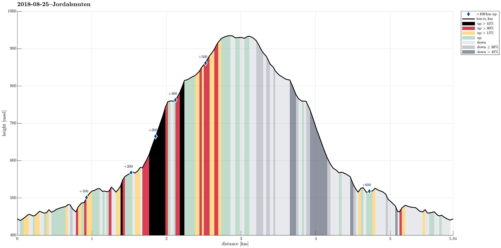 We took road E16 into direction of Gudvangen first and turned to the left (towards Jordalen) after descending into Nærøydalen below Stalheim. We then drove through the new tunnel (now on the eastern side of the valley) up to Jordalen. After leaving the tunnel, we crossed one bridge immediately, before parking the car just ahead of the next bridge. From there we hiked, first over the bridge to the other side of Jordalselvi (to its eastern side), then southwards along the steep eastern side of the valley (into the direction of Jordalsnuten), following a proper path (note that the trail head is not really easy to see; we needed a bit of searching until we found it). It's interesting, also, that the path leads first (more or less) horizontally (with quite a bit of up and down, though) out >>>
Tverråsen, etc., and Furehaugen, etc.
- Date:
- 19.08.2018
- Characteristic:
- Hillwalk
- Duration:
- 4:00h
- Distance:
- 11.0km
 I drove from Bergen to Os in the south and then further into the direction of Hattvika, where a ferry can take you over to Venjaneset (Fusa). Only a few hundred meter before reaching the ferry stop, I turned left and drove up a little road towards Berge. More or less at the first possibility, I parked and started walking (first following the road further up, in northeastern direction). After passing by the houses at Tussaskarva, I found the spot, where the road crosses a little stream, coming down from the right (east). There, it was possible to leave the road and continue on a simple tractor road in northeastern direction (basically following the stream). At about 120mosl, the valley forks into two and I took the left one, continuing in norther direction. This lead me, as expected, to >>>
To Raudlifjellet and back via Hatlelia
- Date:
- 12.08.2018
- Characteristic:
- Hillwalk
- Duration:
- 5:00h
- Distance:
- 10.0km
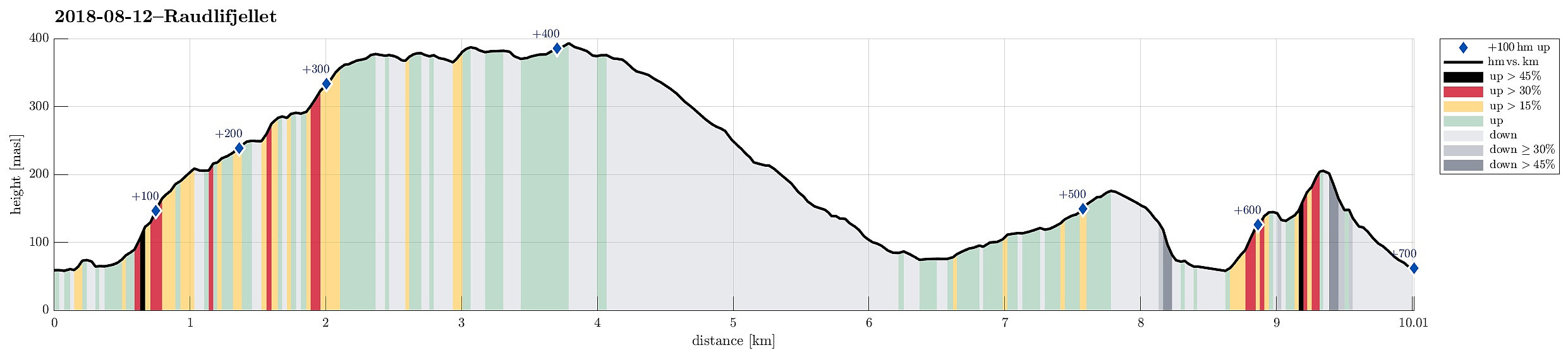 We had the (kind of ambitious) plan to walk a round over Nordhordlandskulten, descending to the south from it (even though it was unclear from the consulted maps, whether this should be reasonably doable, given the also quite steep side of the mountain there). To have the car at the right side of the mountain, we parked along Gåssandvegen near a place called Haukeland. The first task was to find the path, which would lead northover in order to bring us to a place from which it would be reasonable to cross over to the main path up to Nordhordlandskulten (the standard approach is from Tømmernes, a little further north). After a little bit of searching, we quickly found the track which leads northwards into Vetlaleitet (a quite nice little valley, in fact!). We then also found the tractor >>>
