Archive - Date
Archive - Activity
-
Bike trip (137)
- Bike trip - mixed (51)
- Bike trip - road (9)
-
Other trip (1)
- Kayaking (1)
-
Other winter trip (4)
- Snowshoe trip (4)
- Ski trip (4)
- Trip by foot (740)
Archive - Geography
Peakbook-Friends


Collected lists
-
Bergen ≥ 50m pf. og ≥ 100 m.o.h.
(87/89)
 97%
97% -
Most dominating tops of the Bergen peninsula
(68/75)
90%
-
Utvalgte topper og turmål i Bergen
(316/350)
90%
-
Alle topper i Bergen
(357/398)
89%
-
Opptur Bergen
(100/113)
88%
-
De syv fjell rundt Bergen
(6/7)
85%
-
Sund ≥ 50m pf.
(14/18)
77%
-
Os ≥ 50m pf.
(25/34)
73%
-
Søyler (fastmerker) i Bergen
(68/100)
68%
-
Fjell ≥ 50m pf.
(21/32)
65%

Rotterdam-exploration 04: to the Atlantic and back
- Date:
- 19.08.2017
- Characteristic:
- Bike trip
- Duration:
- 6:00h
- Distance:
- 89.4km
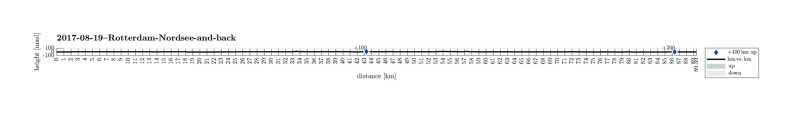 This fourth exploration of Rotterdam on bikes brought us to the west of Rotterdam. We started in Rotterdam Centrum and headed westwards, first. We crossed the Delfshavensche Schie and cycled then towards Schiemond, before we changed direction (towards Schiedam). Passing by Merwehaven, we came to Schiedam, where we turned left (towards the south). At the Nieuwe Maas we then turned right, again, following then the Westfrankelandsedijk towards the west. Passing by Volkspark, we came to Vijfsluizen from where we connected to Vlaardingen. In the west of Vlaardingen, we found a nice biking path through the green and open land there. That brought us to Maassluis, where we connected to the dam (on the northern side of the Nieuwe Maas). We then followed the dam (against some very strong headwinds!) >>>
Rotterdam-exploration 03: Kralingse Plas etc.
- Date:
- 13.08.2017
- Characteristic:
- Bike trip
- Duration:
- 2:00h
- Distance:
- 18.9km
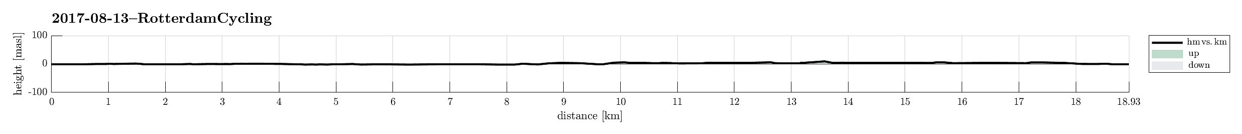 This third exploration of Rotterdam on bikes brought us to the near east of Rotterdam center (we made a round around Kralingse Plas, in a way). We started in Rotterdam Centrum and headed eastwards, first. When we came to Boezem, we turn left (mostly in northern direction) and soon came to the most-western end of Kralingse Plas. Circling this lake on its northern side revealed a large recreational area full of people, enjoying a nice day at the lake. Then, intead of immediately biking home, we made a little extra-exploration of the southeast of Rotterdam. Biking back towards the center of Rotterdam along the Nieuwe Maas was also nice. Before eventually getting back to the center, we crossed over the river (and Noordereiland), biked then along Koningshaven, before getting back to the center >>>
Ameland in the north of Friesland
- Date:
- 09.08.2017
- Characteristic:
- Bike trip
- Duration:
- 3:00h
- Distance:
- 25.2km
 We wished to see a bit of Friesland in the very north of The Netherlands. Thus, we took the ferry to Ameland, where we landed south of Nes. Within minutes, we had rented some bikes and started our little explortion tour in this island. We first followed the dam on the southern side of Ameland towards the west. Even though the entire island is almost completely flat, this part of the tour was kind of demanding due to strong headwinds. After a while, we approached Hollum on the westside of Ameland, where we enjoyed a little break. Before returning, we made a short detour to the big lighthouse of Hollum. Afterwards, we continued back towards Nes, but this time on the northern side of Ameland (amid the wide-stretched dunes of Ameland). About half way back, we stopped for a short exploration >>>
Rotterdam-exploration 02: around the airport in the north
- Date:
- 06.08.2017
- Characteristic:
- Bike trip
- Duration:
- 3:00h
- Distance:
- 26.9km
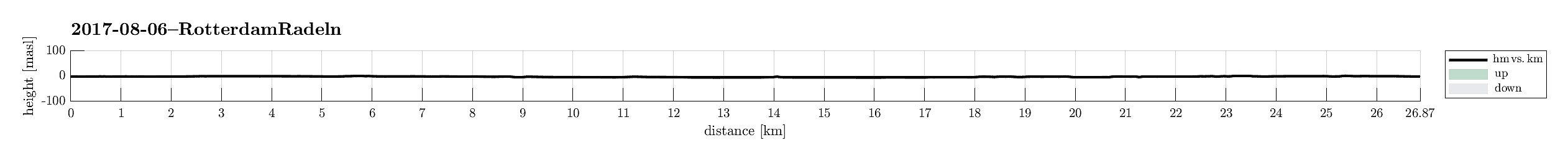 This second exploration of Rotterdam on bikes brought us to the near north of Rotterdam center (we circled Rotterdam airport, in a way). We started in Rotterdam Centrum and headed westwards, first (south of the train tracks). We then turned right (in northwestern direction) and continued into the direction of Overschie. We connected to the dam next to Delftsche Schie and followed it for a short stretch. Then, west of the airport of Rotterdam, we turn right, again, now into northeastern direction (towards Berkel en Rodenrijs). We crossed the fields until we came to the train station of Rodenrijs. Shortly after, we turned right, again (now into southeastern direction). We followed some nice bike paths until we came to the lake(s) Bergsche Voorplas. After a short break, there, we continued >>>
Rotterdam-exploration 01: close to the center
- Date:
- 18.07.2017
- Characteristic:
- Bike trip
- Duration:
- 2:00h
- Distance:
- 20.2km
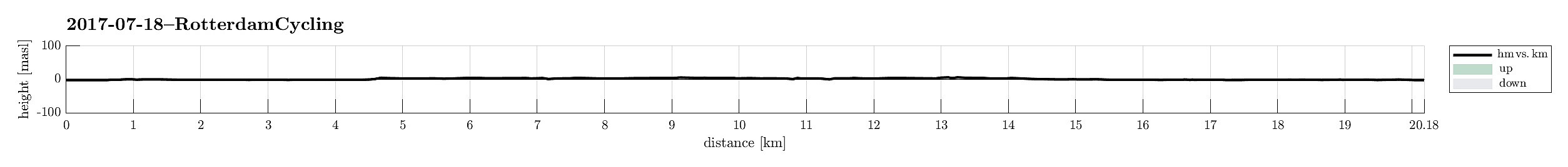 This first exploration of Rotterdam on our bikes brought us first and foremost to its center and then a little around. Rotterdam is really nice to explore on a bike with bike paths in all directions.
Selected photos are available as Google photo album .
See also the FB-page Hiking around Bergen, Norway .
This first exploration of Rotterdam on our bikes brought us first and foremost to its center and then a little around. Rotterdam is really nice to explore on a bike with bike paths in all directions.
Selected photos are available as Google photo album .
See also the FB-page Hiking around Bergen, Norway .
Fana-cycling with Fanasåta
- Date:
- 28.05.2017
- Characteristic:
- Bike trip - mixed
- Duration:
- 5:00h
- Distance:
- 72.7km
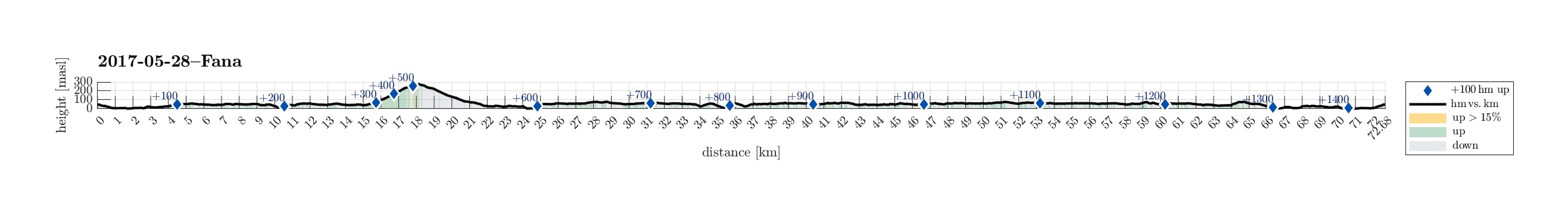 I took my bike southwards from Varden, Fyllingsdalen, first passing by Søreide into the direction of Hjellestad. After having crossed the street to the airport, I turned sharply left at Blomsterdalen, continuing on the small road #172 towards Fana. At Skeie, I made sure to connect to the even smaller road, which passes by Hordnesskogen. At Stend, I connected with the main road to Fana, #546, coming there from Rådalen. I then cycled by Fana and continued on road #163 up to Fanafjellet. Even though the height difference is not much, this ascent clearly is tougher than cycling on level ground. :-)
At Fanafjellet, I parked my bike in order to make a short detour to Fanasåta. Right before (north of) the big parking place on the saddle on Fanafjellet, a little forest road leaves to the northeast, >>>
I took my bike southwards from Varden, Fyllingsdalen, first passing by Søreide into the direction of Hjellestad. After having crossed the street to the airport, I turned sharply left at Blomsterdalen, continuing on the small road #172 towards Fana. At Skeie, I made sure to connect to the even smaller road, which passes by Hordnesskogen. At Stend, I connected with the main road to Fana, #546, coming there from Rådalen. I then cycled by Fana and continued on road #163 up to Fanafjellet. Even though the height difference is not much, this ascent clearly is tougher than cycling on level ground. :-)
At Fanafjellet, I parked my bike in order to make a short detour to Fanasåta. Right before (north of) the big parking place on the saddle on Fanafjellet, a little forest road leaves to the northeast, >>>
Cycling to Askøy with Folleseåsen
- Date:
- 27.05.2017
- Characteristic:
- Bike trip - mixed
- Duration:
- 3:00h
- Distance:
- 30.8km
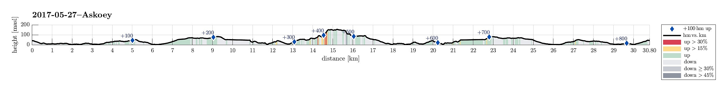 We started our little cycling trip in the south of Fyllingsdalen and took Bjørgeveien towards Loddefjord. From there, we connected to Kjøkkelvikveien and at Nybø, we connected to Sundby Hvorups vei, which brings cyclists (and pedestrians) to the southern end of the large bridge to Askøy (drivers take a tunnel). We crossed over the Askøy-bridge and followed the sidewalk to the place, where a bigger bus-stop is. There, right behind the bus-stop, a steep path is leading downwards to Skarholmvegen. Turning sharply right, once down there, we took Skarholmvegen towards the west on the southern edge of Askøy. We followed this road until we came to Strusshamn, where we continued northover (and upwards), until we got to Follesevegen. There, we continued again westwards (a little), until >>>
Askøy-cycling with Åsebøåsen
- Date:
- 14.05.2017
- Characteristic:
- Bike trip - mixed
- Duration:
- 3:30h
- Distance:
- 53.4km
 I took my bicycle from Varden in the southwest of Fyllingsdalen and followed first Bjørgeveien towards Loddefjord. Shortly before getting there, I first thought to take the pedestrians' bridge over Lyderhornveien in order to get to Bjørndalsbakken. I was mislead, there, however, since the according signs were crossed out. Thus, I thought that I had no other choice than to use Lyderhornveien in order to get to Loddefjord (not the nicest street to cycle). From Loddefjord, I continued along Lyderhornveien in northern direction (here it's fully OK to cycle), until I got to Kjøkkelvikveien, which I followed further northwards. Via Krabbedalsflaten, I got further to Sundby Hvorups vei, which I cycled upwards and over a minor top in order to connect to the big Askøy-bridge (only possible >>>
Cycling around Copenhagen
- Date:
- 06.05.2016
- Characteristic:
- Bike trip
- Duration:
- 6:00h
- Distance:
- 63.6km
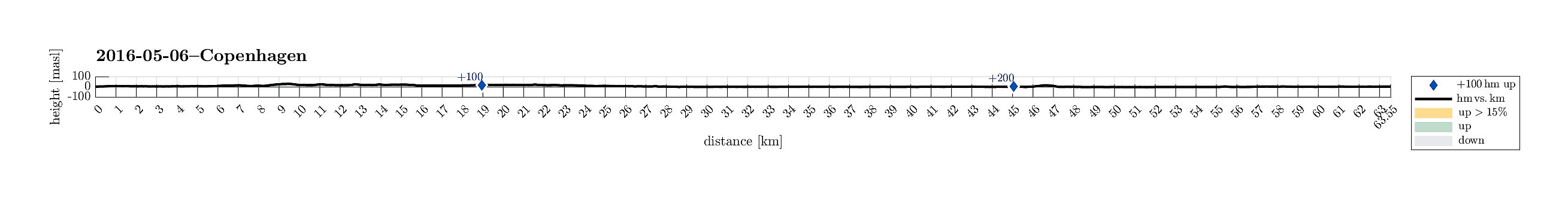 We started directly from WakeUpCopenhagen with the bikes that we had rented from there the day before. Our first goal, Utterslev Mose, is towards the northwest from Copenhagen center, so we cycled towards Nørreport, first. At Søerne (The Lakes!), we cycled them up and down once---more, because we were unsure, first, of where to continue, but then also to enjoy this nice area! :-) After that, we followed Tagensvej towards Bispebjerg. At the graveyard of Bispebjerg, we got to see the impressive church Grundtvigskirken, reminding us strongly of the also impressive church in Reykjavík, Iceland. From there, we continued towards Utterslev Mose, a nice recreational area, previously part of the defense system of Copenhagen. There, we met the cycling path #9, which continues along Vestvolden---an >>>
Copenhagen-Humlebæk-Copenhagen
- Date:
- 05.05.2016
- Characteristic:
- Bike trip
- Duration:
- 6:00h
- Distance:
- 71.8km
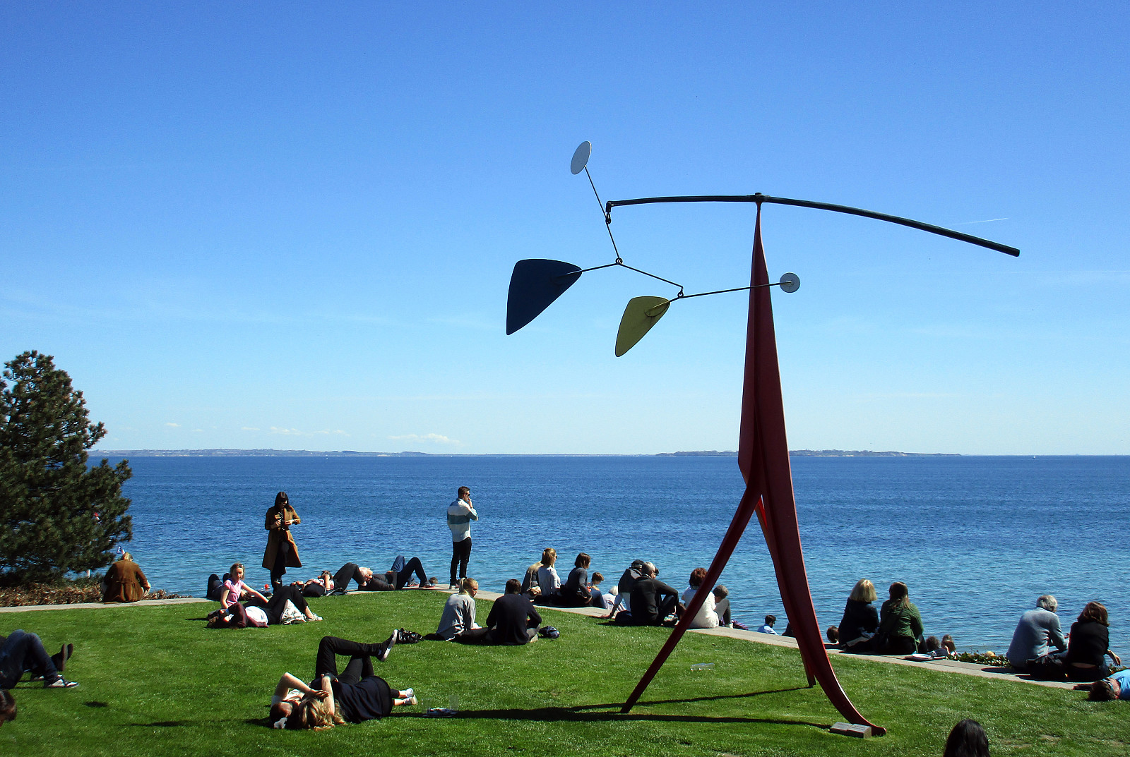 We had a room in WakeUpCopenhagen (Borgergade) and rented bikes---typical Danish bikes with three gears---from there. We headed first towards Kastellet and aimed then at Strandvejen, which leads all the way towards the north. Cycling in Copenhagen, Denmark, is really great: lots of space for cyclists, not much up and down---nice and easy! :-) Near the Tuborg factory, we met the cycling path #9, which connects to the north along Strandvejen. Cycling along Strandvejen is nice with lots of great views over the sea to the east. At Skodsborg, we should have understood that cycling path #9 is continuing in parallel to Strandvejen---a little further away from the sea. Instead, we continued along Strandvejen, which was OK, but a little less fun, since no cycling path is available at this stretch. >>>
