Archive - Date
Archive - Activity
-
Bike trip (137)
- Bike trip - mixed (51)
- Bike trip - road (9)
-
Other trip (1)
- Kayaking (1)
-
Other winter trip (4)
- Snowshoe trip (4)
- Ski trip (4)
- Trip by foot (740)
Archive - Geography
Peakbook-Friends


Collected lists
-
Bergen ≥ 50m pf. og ≥ 100 m.o.h.
(87/89)
 97%
97% -
Most dominating tops of the Bergen peninsula
(68/75)
90%
-
Utvalgte topper og turmål i Bergen
(316/350)
90%
-
Alle topper i Bergen
(357/398)
89%
-
Opptur Bergen
(100/113)
88%
-
De syv fjell rundt Bergen
(6/7)
85%
-
Sund ≥ 50m pf.
(14/18)
77%
-
Os ≥ 50m pf.
(25/34)
73%
-
Søyler (fastmerker) i Bergen
(68/100)
68%
-
Fjell ≥ 50m pf.
(21/32)
65%

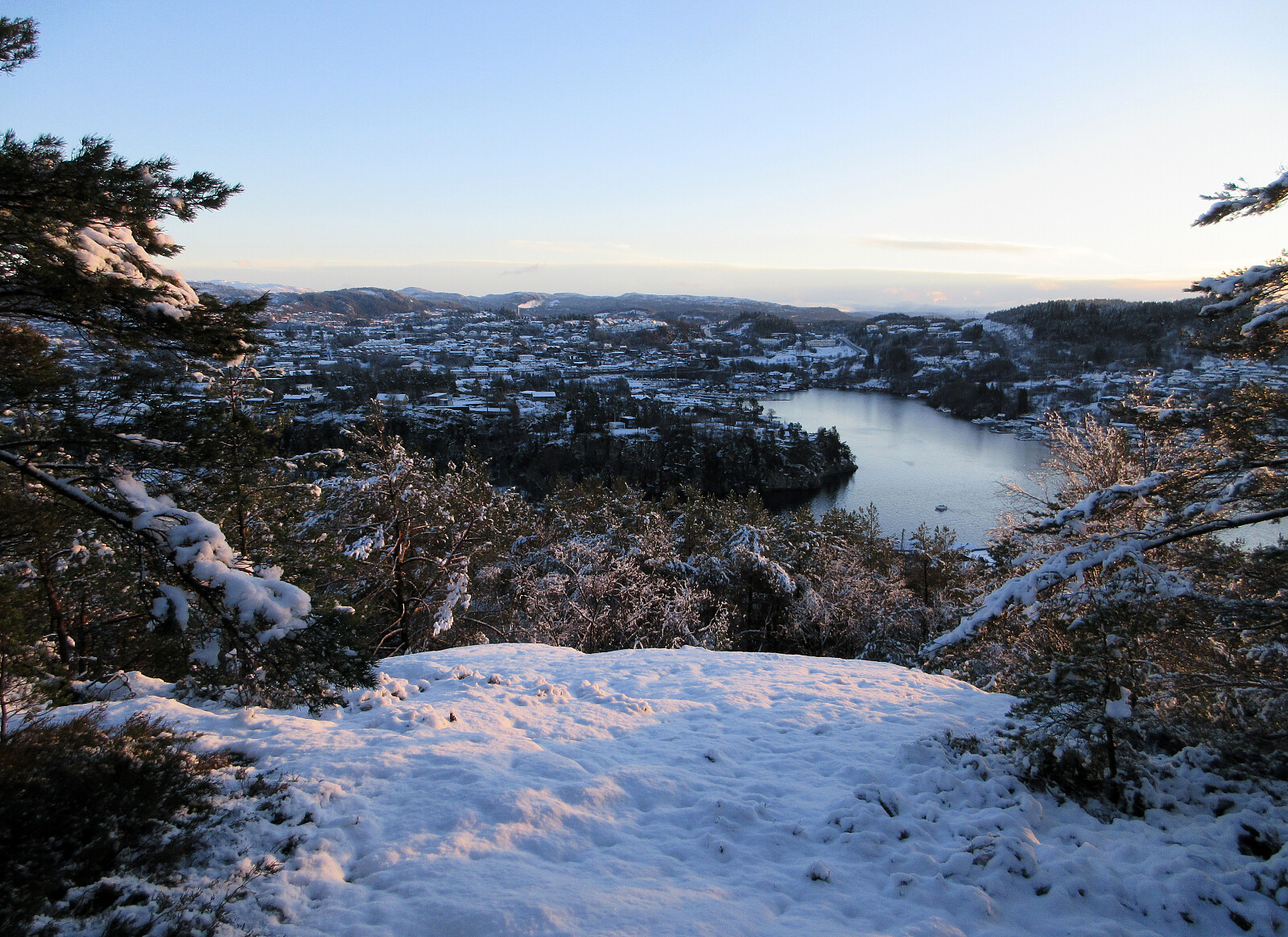
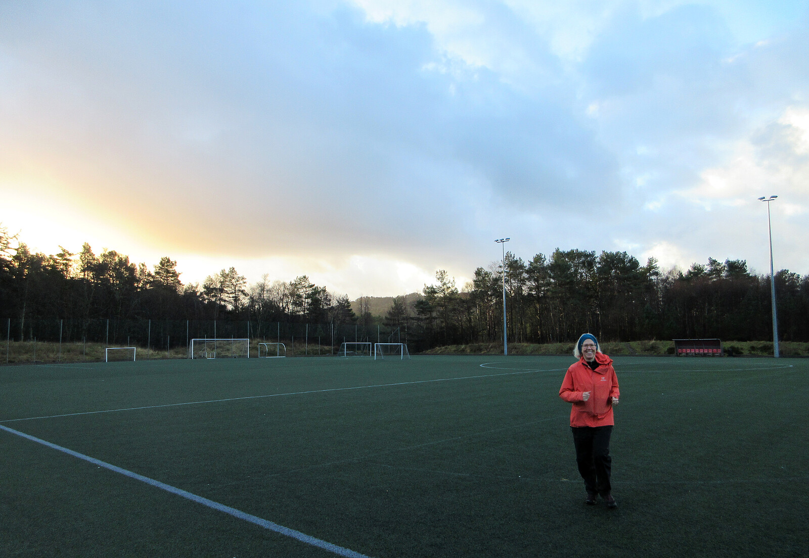
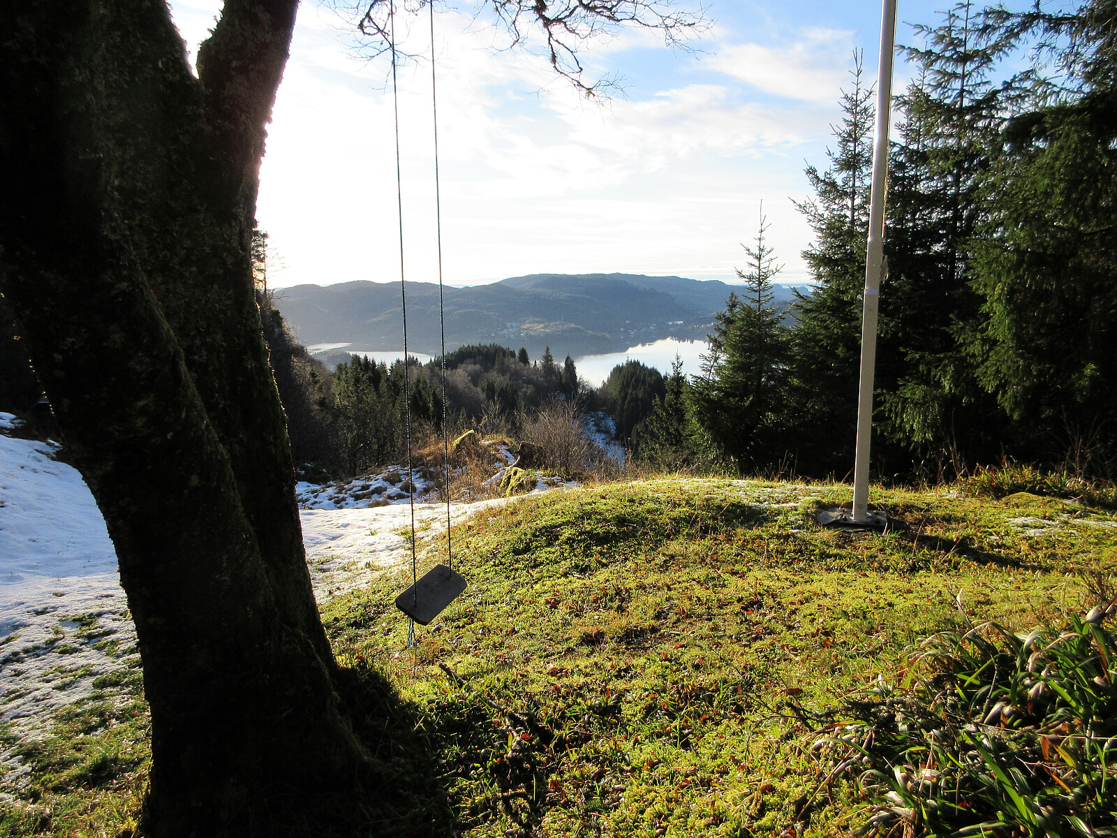
Storhovden and Svartaberget from Varden
- Date:
- 02.01.2026
- Characteristic:
- Hillwalk
- Duration:
- 3:00h
- Distance:
- 9.5km
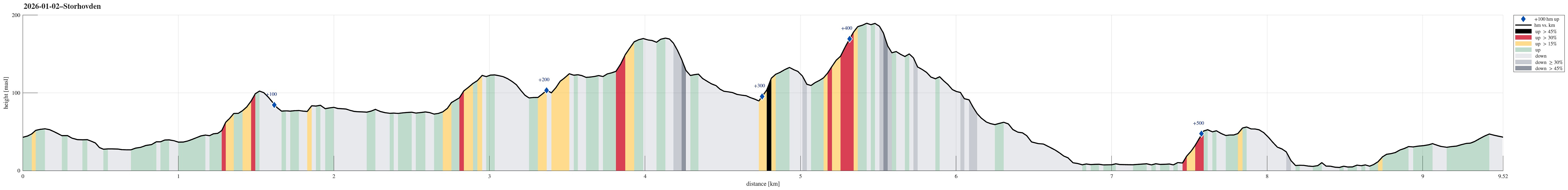 We started northwards from Varden, crossing the soccer fields to get closer to Kanadaskogen near Hesjaholten. After paying Hesjaholten a short visit, we continued further towards Krokatjørna. This time, we decided to cross over Langaheia from the south, before connecting to Storhovden via Spelhaugen. Since the day was indeed very nice, we then decided to also include Svartaberget via Storamyra where it was nice to also look up to TOBRIK. On Svartaberget, we then enjoyed a really nice winter view towards the west before starting our walk back southwards. After passing by Bjørndalsvatnet and Gjeddevatnet, we arrived back at Varden with good satisfaction about the very nice day!
Selected photos are available as Google photo album .
See also the related FB-page Hiking around Bergen, Norway .
We started northwards from Varden, crossing the soccer fields to get closer to Kanadaskogen near Hesjaholten. After paying Hesjaholten a short visit, we continued further towards Krokatjørna. This time, we decided to cross over Langaheia from the south, before connecting to Storhovden via Spelhaugen. Since the day was indeed very nice, we then decided to also include Svartaberget via Storamyra where it was nice to also look up to TOBRIK. On Svartaberget, we then enjoyed a really nice winter view towards the west before starting our walk back southwards. After passing by Bjørndalsvatnet and Gjeddevatnet, we arrived back at Varden with good satisfaction about the very nice day!
Selected photos are available as Google photo album .
See also the related FB-page Hiking around Bergen, Norway .
Knappen from the south
- Date:
- 01.01.2026
- Characteristic:
- Hillwalk
- Duration:
- 1:00h
- Distance:
- 5.4km
 With a new year, we immediately got a new chance to visit Knappen! :-) This time, we first headed to Knappatjørna, before then approaching Knappen from the south. For a small change, we first stepped up to Hesthaugen, before eventually visiting Knappen and Eldtona.
See also the related FB-page Hiking around Bergen, Norway .
On web page prominent-mountains.no , there's a useful page about Knappen .
Web page UT.no from the Norwegian Trekking Association recommends another hike to Knappen .
With a new year, we immediately got a new chance to visit Knappen! :-) This time, we first headed to Knappatjørna, before then approaching Knappen from the south. For a small change, we first stepped up to Hesthaugen, before eventually visiting Knappen and Eldtona.
See also the related FB-page Hiking around Bergen, Norway .
On web page prominent-mountains.no , there's a useful page about Knappen .
Web page UT.no from the Norwegian Trekking Association recommends another hike to Knappen .
Førdesveten from Kleppe
- Date:
- 27.12.2025
- Characteristic:
- Hike
- Duration:
- 2:30h
- Distance:
- 8.1km
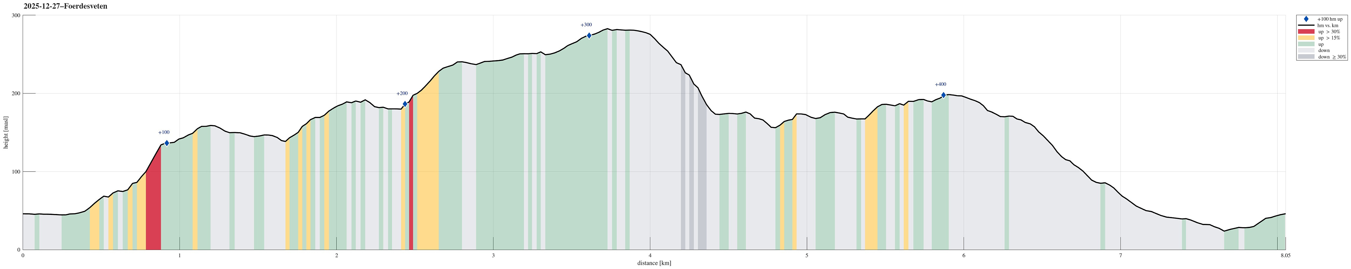 Yes, quite some wind was predicted, but still the weather seemed too good to not go out for a short while. After enjoying a nice round around Dyrdalsvatnet the day before, we decided that it should be Førdesveten south in Øygarden this day. We parked in Kleppe and took the route via Høylandsfjellet, Midtfjellet, and Lyngfjellet up to Veten. The higher we got, the more we experienced the rather strong winds! Near the top, we then took a short break in the still relatively new Dagsturhytten before heading back down via Ramnaberget and Kleppaksla. On the way down from Kleppaksla, we found a trail with pink markers in the southwest of Fenadalen, which brought us down to Sundvegen not far from where we had parked.
Selected photos are available as Google photo album .
See also the related FB-page Hiking around Bergen, Norway .
Petter Bjørstad has a useful page about Veten and also web page WestCoastPeaks.com provides useful information about Førdesveten .
Web >>>
Yes, quite some wind was predicted, but still the weather seemed too good to not go out for a short while. After enjoying a nice round around Dyrdalsvatnet the day before, we decided that it should be Førdesveten south in Øygarden this day. We parked in Kleppe and took the route via Høylandsfjellet, Midtfjellet, and Lyngfjellet up to Veten. The higher we got, the more we experienced the rather strong winds! Near the top, we then took a short break in the still relatively new Dagsturhytten before heading back down via Ramnaberget and Kleppaksla. On the way down from Kleppaksla, we found a trail with pink markers in the southwest of Fenadalen, which brought us down to Sundvegen not far from where we had parked.
Selected photos are available as Google photo album .
See also the related FB-page Hiking around Bergen, Norway .
Petter Bjørstad has a useful page about Veten and also web page WestCoastPeaks.com provides useful information about Førdesveten .
Web >>>
Slettegga, Austefjellet, and Hausdalshorgi
- Date:
- 26.12.2025
- Characteristic:
- Hike
- Duration:
- 5:00h
- Distance:
- 13.3km
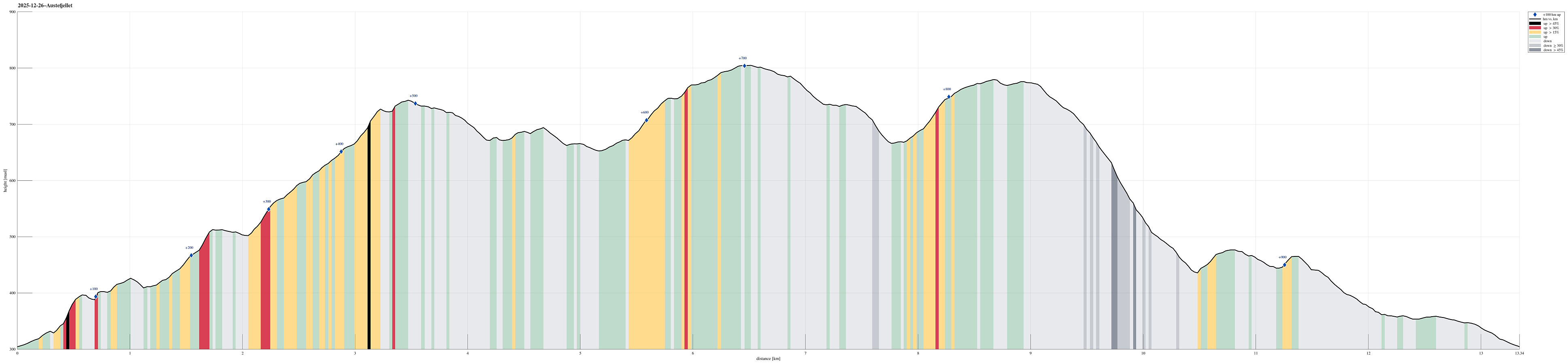 We expected a nice winter day and started a bit earlier than usually to exploit the short daylight period as well as possible. After driving up to Bontveit and parking there right next to the saddle, we started first hiking northwards along Bontveitvegen. Very soon, however, we turned left to explore Åsane (in parallel to Bontveitvegen). While it was fully possible to traverse Åsane, also without any trail, it occasionally got a touch of a nice xMas bush war. At Langemyrskaret, we reconnected with Bontveitvegen, having a nice chat with another hiker, who had enjoyed the rising sun from Slettegga. Then, instead of following the standard trail up to Slettegga, we included another small exploration: Halvardshaugen in the northwest of Bjørnstølåsen, from which we enjoyed some really nice >>>
Løvstakken from/to Bergen
- Date:
- 25.12.2025
- Characteristic:
- Hike
- Duration:
- 1:30h
- Distance:
- 6.7km
 Even though it was a bit late, already, we still wished to make a quick round somewhere near. Doing Løvstakken from the Bergen-side seemed just right (and so it was). We used the gravel road that starts from Løvstien just above Solheimslien to get up. On Løvstakken, we met an unexpected sight: most of one of the two masts was missing from its top -- what's happening? :-) To get back down, we chose to cross over Ravnefjellet and then use Løvstien to get back around to the Bergen-side. Our timing was just right to return before it got all dark.
Selected photos are available as Google photo album .
See also the related FB-page Hiking around Bergen, Norway .
Web page WestCoastPeaks.com provides useful information about Løvstakken .
Even though it was a bit late, already, we still wished to make a quick round somewhere near. Doing Løvstakken from the Bergen-side seemed just right (and so it was). We used the gravel road that starts from Løvstien just above Solheimslien to get up. On Løvstakken, we met an unexpected sight: most of one of the two masts was missing from its top -- what's happening? :-) To get back down, we chose to cross over Ravnefjellet and then use Løvstien to get back around to the Bergen-side. Our timing was just right to return before it got all dark.
Selected photos are available as Google photo album .
See also the related FB-page Hiking around Bergen, Norway .
Web page WestCoastPeaks.com provides useful information about Løvstakken .
Round around Sælenvatnet with Barhaugen
- Date:
- 20.12.2025
- Characteristic:
- Hillwalk
- Duration:
- 2:00h
- Distance:
- 8.3km
 We wished to get some fresh air, or so, and thus headed out to a short round around Sælenvatnet. The first goal was to walk around Bondegården along the northern shore of Sælenvatnet (even though it gets quite a bit wet on the southeastern side of Bondegården). After crossing the bridge north of Øyrane, we then continued along Sælenveien, before finding a connection up to Stokkedalen. There, we then scaled the rather steep hillside up to the upper stretch of Rekdalsveien. From there, it was then over to Barhaugen and back down towards Straumshaugen. While all of this round was not really spectacular, we did catch some nice winter light. :-)
Selected photos are available as Google photo album .
See also the related FB-page Hiking around Bergen, Norway .
We wished to get some fresh air, or so, and thus headed out to a short round around Sælenvatnet. The first goal was to walk around Bondegården along the northern shore of Sælenvatnet (even though it gets quite a bit wet on the southeastern side of Bondegården). After crossing the bridge north of Øyrane, we then continued along Sælenveien, before finding a connection up to Stokkedalen. There, we then scaled the rather steep hillside up to the upper stretch of Rekdalsveien. From there, it was then over to Barhaugen and back down towards Straumshaugen. While all of this round was not really spectacular, we did catch some nice winter light. :-)
Selected photos are available as Google photo album .
See also the related FB-page Hiking around Bergen, Norway .
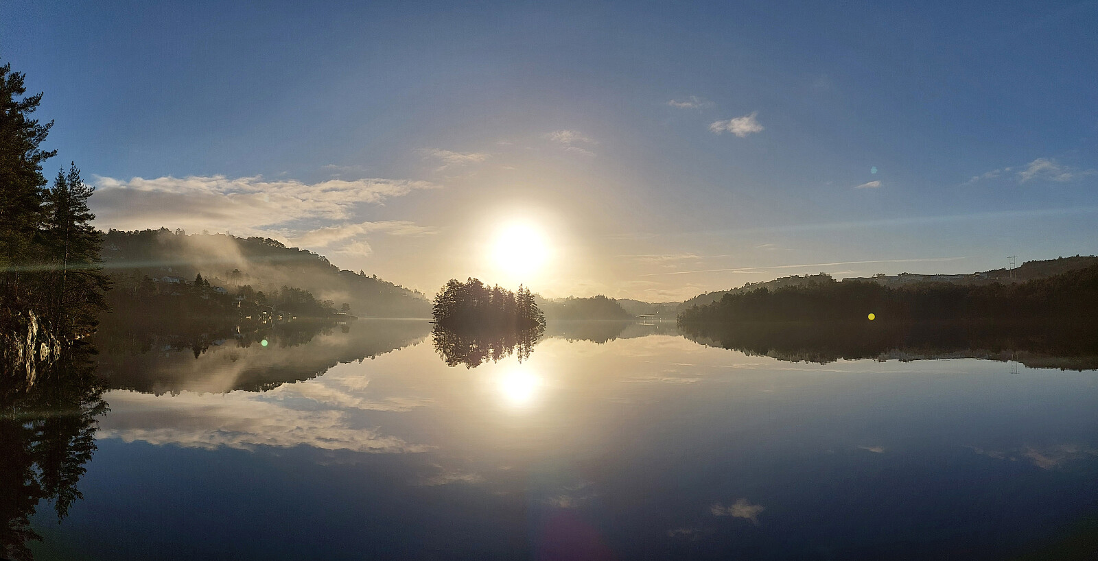
Gjeddevatnet and back
- Date:
- 13.12.2025
- Characteristic:
- Walk
- Duration:
- 0:30h
- Distance:
- 1.9km
 It was just to stretch our legs a little: quickly to Gjeddevatnet and back! :-)
See also the related FB-page Hiking around Bergen, Norway .
It was just to stretch our legs a little: quickly to Gjeddevatnet and back! :-)
See also the related FB-page Hiking around Bergen, Norway .
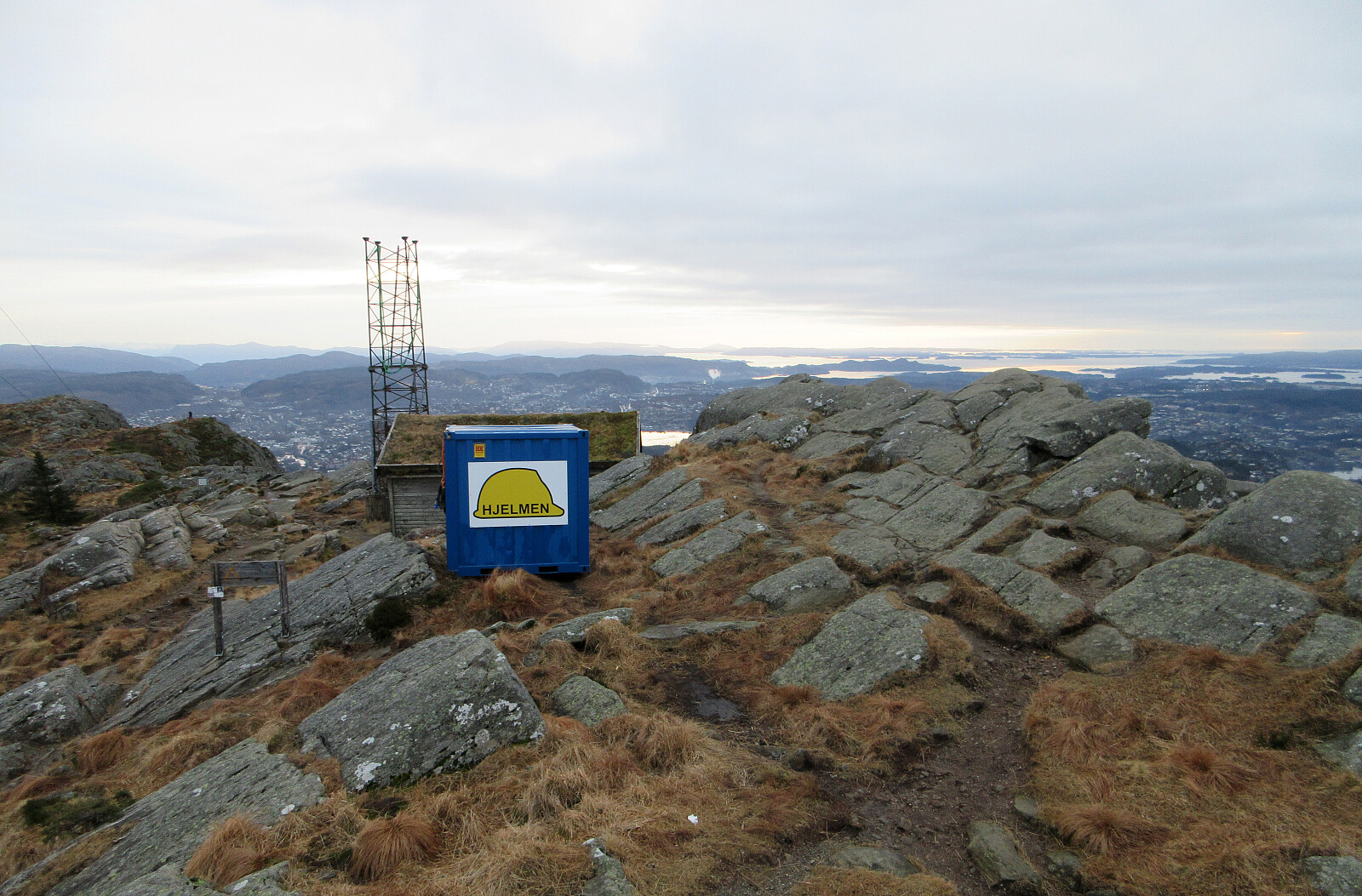
Lyderhorn via Skarpafjellet
- Date:
- 06.12.2025
- Characteristic:
- Hike
- Duration:
- 1:30h
- Distance:
- 4.5km
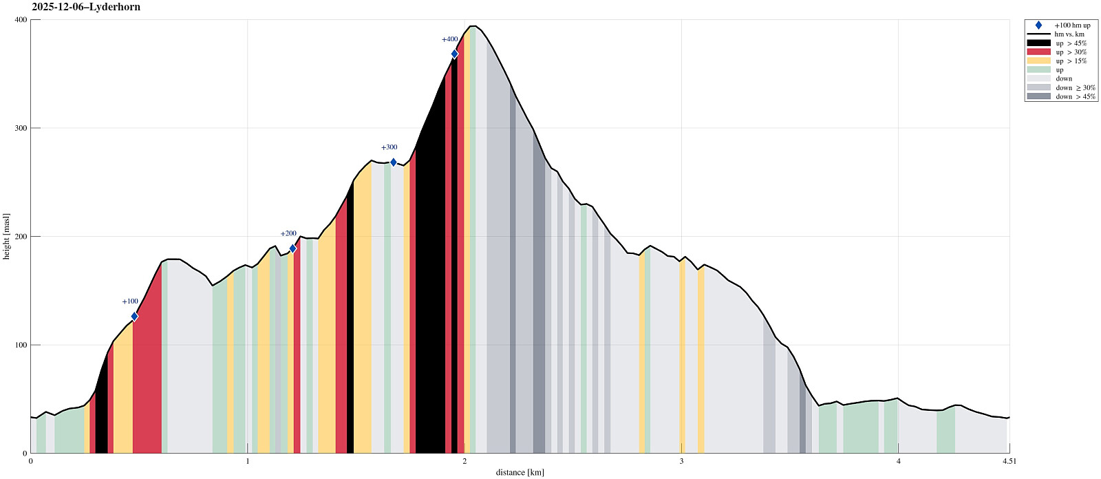 Aiming at some nice but not too long weekend hike, we decided to visit Lyderhorn (again). The plan was to ascend via Skarpafjellet in the south of Lyderhorn. We parked at Bjørndalen and tried an as direct as possible (off-trail) ascent to Skarpafjellet, first. As soon as we had left road Sildaberget (right next to Lyderhornsveien), we immediately found ourselves (not unexpectedly, though) in rather steep terrain, which required a bit of hand help to make it up between the rocks. As soon as we were up to about 90masl, however, progress became easier and rather straight-forward -- all the way to the top of Skarpafjellet. This southern flank of Skarpafjellet is actually very nice, offering some nice views over Bjørndalen and Bjørndalspollen. From Skarpafjellet, we then followed the main >>>
A dragon on Knappen?
- Date:
- 29.11.2025
- Characteristic:
- Hike
- Duration:
- 1:30h
- Distance:
- 5.5km
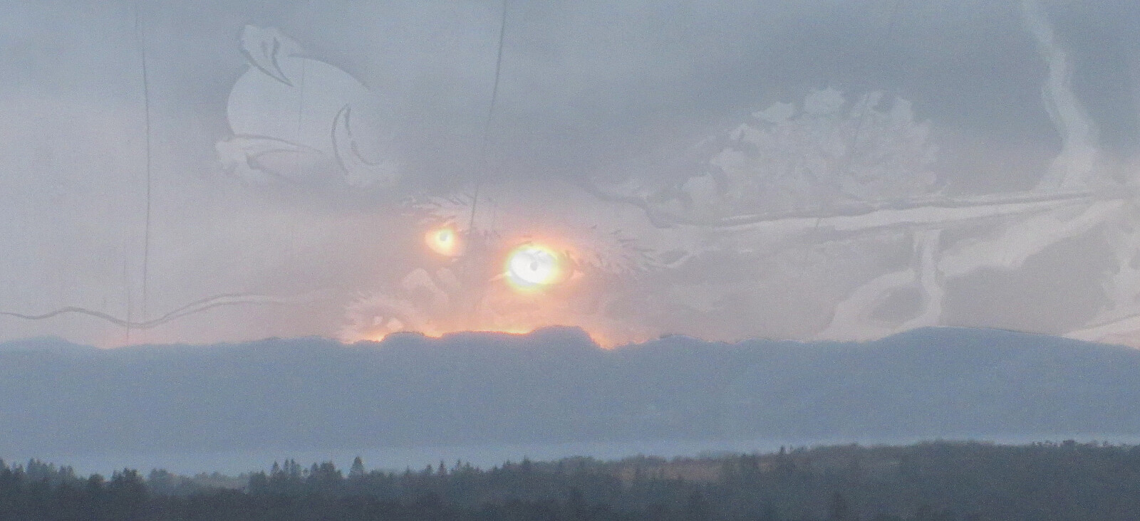 When the winter days are short, it's sometimes no more than "just" making a quick (but still nice!) round across Knappen! :-)
Selected photos are available as Google photo album .
See also the related FB-page Hiking around Bergen, Norway .
Petter Bjørstad has a useful page about Knappen .
Web page UT.no from the Norwegian Trekking Association recommends another hike to Knappen .
When the winter days are short, it's sometimes no more than "just" making a quick (but still nice!) round across Knappen! :-)
Selected photos are available as Google photo album .
See also the related FB-page Hiking around Bergen, Norway .
Petter Bjørstad has a useful page about Knappen .
Web page UT.no from the Norwegian Trekking Association recommends another hike to Knappen .
Kubrekka from/to Sandven
- Date:
- 23.11.2025
- Characteristic:
- Hike
- Duration:
- 1:30h
- Distance:
- 3.9km
 We had time for a relatively short walk but still were interested in exploring opportunities to do something new. Expecting chances for some low-standing November sun from the southwest, we thought that hiking up to Kubrekka from Sandven right next to Kalandsvatnet could be a reasonable option (yes, when "digging deeper", we read in Harald's trip report that the top had no views and is of no interest to normal hikers; but then: are we normal hikers? :-)). The main idea was to go up via Stemmedalen, then cross over Kubrekka from the northwest to the southeast, before then walking down Høgerinden in parallel to Tjørnadalen to get back to Sandven. When aiming for Stemmedalen from Osvegen, however, we faced a sign informing us that someone would not like us to proceed further towards Stemmedalen along >>>
