Archive - Date
Archive - Activity
-
Bike trip (137)
- Bike trip - mixed (51)
- Bike trip - road (9)
-
Other trip (1)
- Kayaking (1)
-
Other winter trip (4)
- Snowshoe trip (4)
- Ski trip (4)
- Trip by foot (740)
Archive - Geography
Peakbook-Friends


Collected lists
-
Bergen ≥ 50m pf. og ≥ 100 m.o.h.
(87/89)
 97%
97% -
Most dominating tops of the Bergen peninsula
(68/75)
90%
-
Utvalgte topper og turmål i Bergen
(316/350)
90%
-
Alle topper i Bergen
(357/398)
89%
-
Opptur Bergen
(100/113)
88%
-
De syv fjell rundt Bergen
(6/7)
85%
-
Sund ≥ 50m pf.
(14/18)
77%
-
Os ≥ 50m pf.
(25/34)
73%
-
Søyler (fastmerker) i Bergen
(68/100)
68%
-
Fjell ≥ 50m pf.
(21/32)
65%

Gjønakvitingen from Gjøn (via Selfjellet)
- Date:
- 17.08.2025
- Characteristic:
- Hike
- Duration:
- 8:00h
- Distance:
- 13.5km
 The weather was promising and so we thought this would be a good day to hike up to Gjønakvitingen from Gjøn. From Bergen, we drove towards the East, first along E16, then road #49, before taking road #48 to Eikelandsosen. From there, it was not too far, continuing into eastern direction, before we changed to a narrow road at Holdhus. This way, we drove around the south end of Gjønavatnet in order to get to Gjønavegen, which brought us to Gjøn. At about noon-time, we then started our hike (with enough time on such a nice, long summer Sunday). The one, small "twist", which we had cooked up, when studying the map at home, was to include Selfjellet (via an ascent on the western side of Skarvaelva), before eventually taking the "main trail" down (south of Sauaskorfjellet). >>>
Almelandsfjellet etc.
- Date:
- 10.08.2025
- Characteristic:
- Hillwalk
- Duration:
- 3:00h
- Distance:
- 6.2km
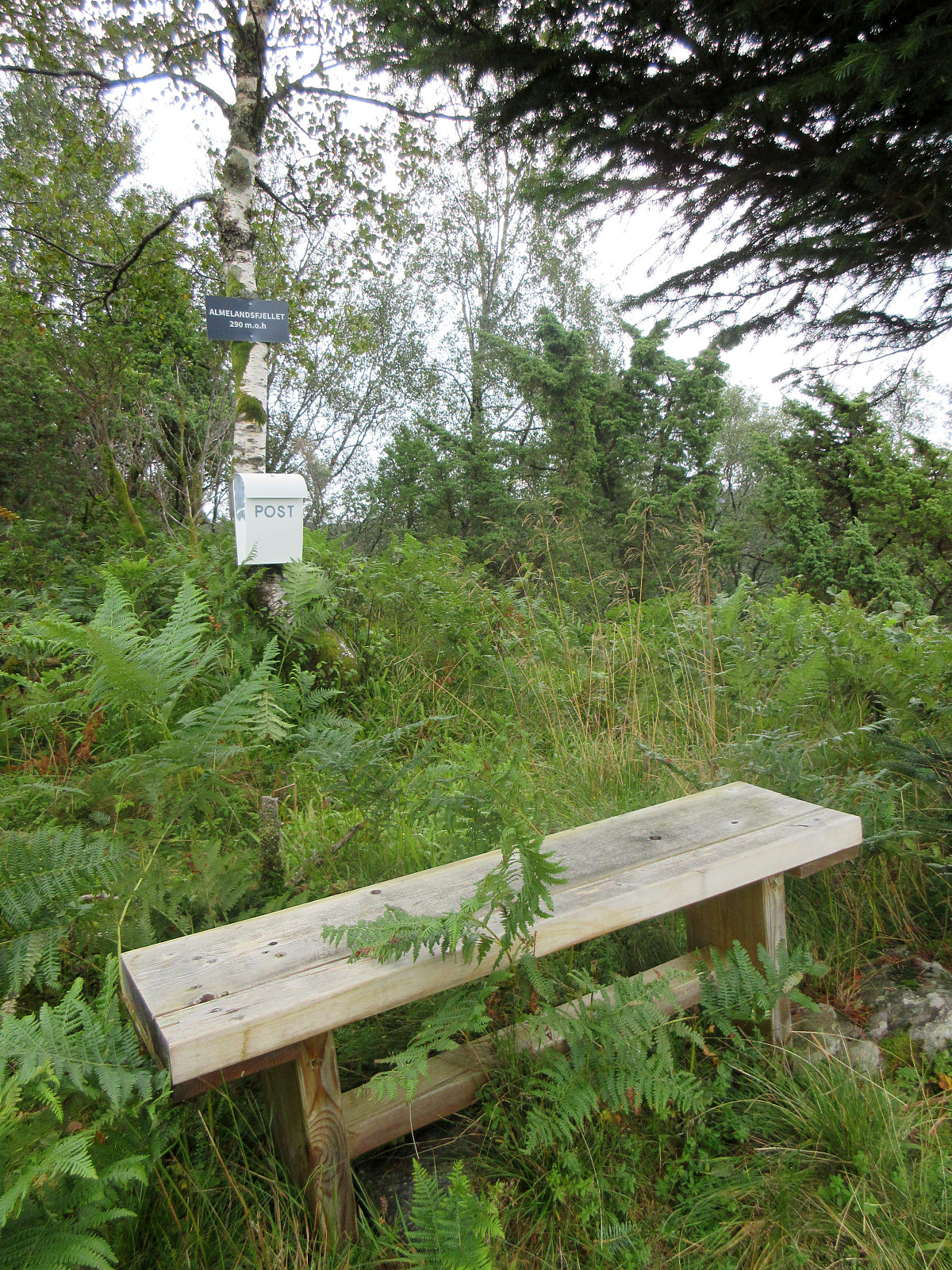 On this partially wet Sunday, the plan was to make something not too long and not too far away. Since I had not visited Smørkisfjellet before, I "cooked up" a round, starting from Osvegen near Kalandseidet. I somehow thought that I could try an ascent to Blåurskampen from the west (even though I had seen during my map study at home that this side of this hill is very steep with quite some cliffs, actually). I started from right underneath Blåurskampen and already down at Osvegen I wondered whether this really was such a good idea (it was not). I still entered the terrain and quickly found out: (a) it was wet from all the rain, (b) there was a lot of vegetation, and (c) it is truly steep -- at times way too steep there. I still continued (why?), making height meters relatively >>>
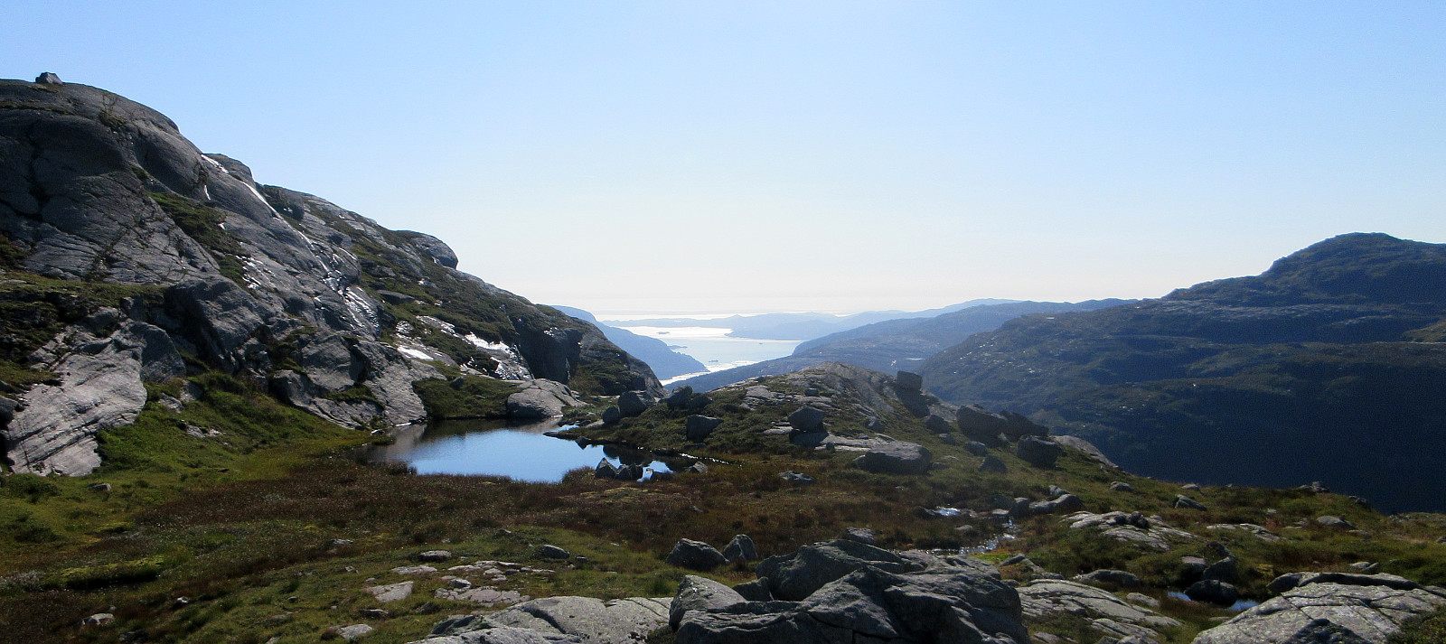
Byrkjefjellet, Iendefjellet, and Skeisheia
- Date:
- 02.08.2025
- Characteristic:
- Hike
- Duration:
- 7:00h
- Distance:
- 16.5km
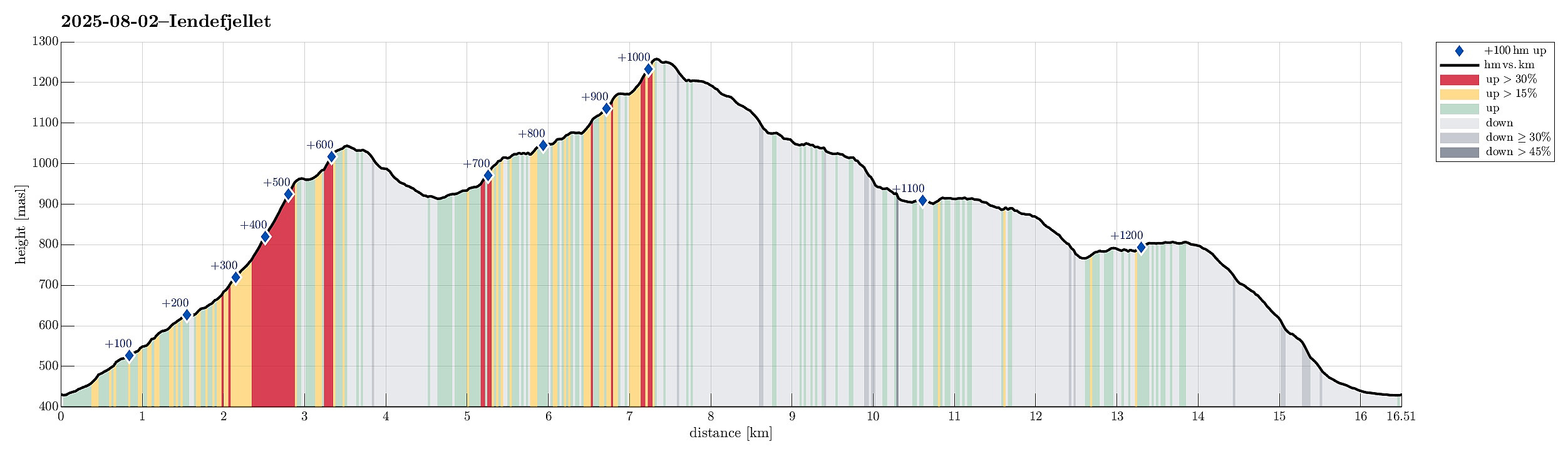 We expected "one last nice day before the rain" and thus aimed at one more nice hike! :-) Without much hesitation, we agreed to make a hike to Iendefjellet, north of Kvamskogen. We took the car from Bergen to Kvamskogen and parked at the southern end of Tryglakleiv, right next to the "main road" across Kvamskogen (road #49). We then started to hike up road Tryglakleiv, aiming at the heights in the southwest of Tryglakleivtjørnane. All of this is easy to find and from "up there" (a bit below 600 masl), the real ascent towards Byrkjefjellet starts (then mostly in northern direction). Following a proper trail, we completed the (partially steep) ascent relatively quickly. It was, however, very hot and we recognized and respected the roughly 600 height meters >>>
Livarden from Haukelandsvatnet
- Date:
- 27.07.2025
- Characteristic:
- Hike
- Duration:
- 4:00h
- Distance:
- 7.9km
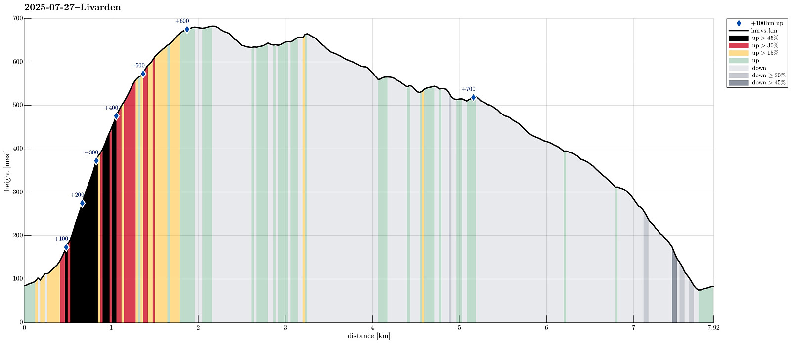 We wished to use (part of) the nice Sunday for a nice hike and chose Livarden, not far from Bergen. Instead of the usual hike (from Totland), we decided to approach it "direttissima" from Haukelandsvatnet. We parked in the southeast of Nygardsvika (langs Unnelandsvegen) and started in easterly direction -- to pass by (and below) Kalvehalsen. For a bit, we followed a (faint) trail, which leads up to a small building south (and above) Kalvehalsen. Instead of following this trail for any longer part, however, we quickly aimed at Stallafossen (there wasn't much to see or hear of this waterfall, though -- probably due to the rather dry perdiod during the past days). The goal was to ascend to a ridge in the south of Stallafossen (the first "big" one on the westside of the >>>
Exploring Suomenlinna south of Helsinki
- Date:
- 12.07.2025
- Characteristic:
- Walk
- Duration:
- 2:30h
- Distance:
- 5.8km
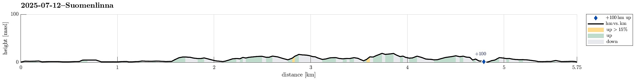 Our travel itinerary included about 24 hours in Helsinki before the follow-up flight further west. Exploiting our massive time confusion -- 6 am in Helsinki was like noon-time in Tokyo, after all -- we headed straight for the city center of Helsinki and from their, using the public ferry, to Suomenlinna, i.e., an island a bit south of the center of Helsinki, which previously was fortified massively. Today, quite a few visit this island, apparently, to see these fortifications. Before mostly following the "main-trail" across the island, we included a short detour to Pikku-Musta and Länsi-Musta, also. At the southern-most part of Suomenlinna, we then made a round around the fortifications before head back to the ferry quay where we had arrived earlier.
Selected photos are available >>>
Our travel itinerary included about 24 hours in Helsinki before the follow-up flight further west. Exploiting our massive time confusion -- 6 am in Helsinki was like noon-time in Tokyo, after all -- we headed straight for the city center of Helsinki and from their, using the public ferry, to Suomenlinna, i.e., an island a bit south of the center of Helsinki, which previously was fortified massively. Today, quite a few visit this island, apparently, to see these fortifications. Before mostly following the "main-trail" across the island, we included a short detour to Pikku-Musta and Länsi-Musta, also. At the southern-most part of Suomenlinna, we then made a round around the fortifications before head back to the ferry quay where we had arrived earlier.
Selected photos are available >>>
Round around the Imperial Palace (and Kanda)
- Date:
- 11.07.2025
- Characteristic:
- Walk
- Duration:
- 7:00h
- Distance:
- 13.1km
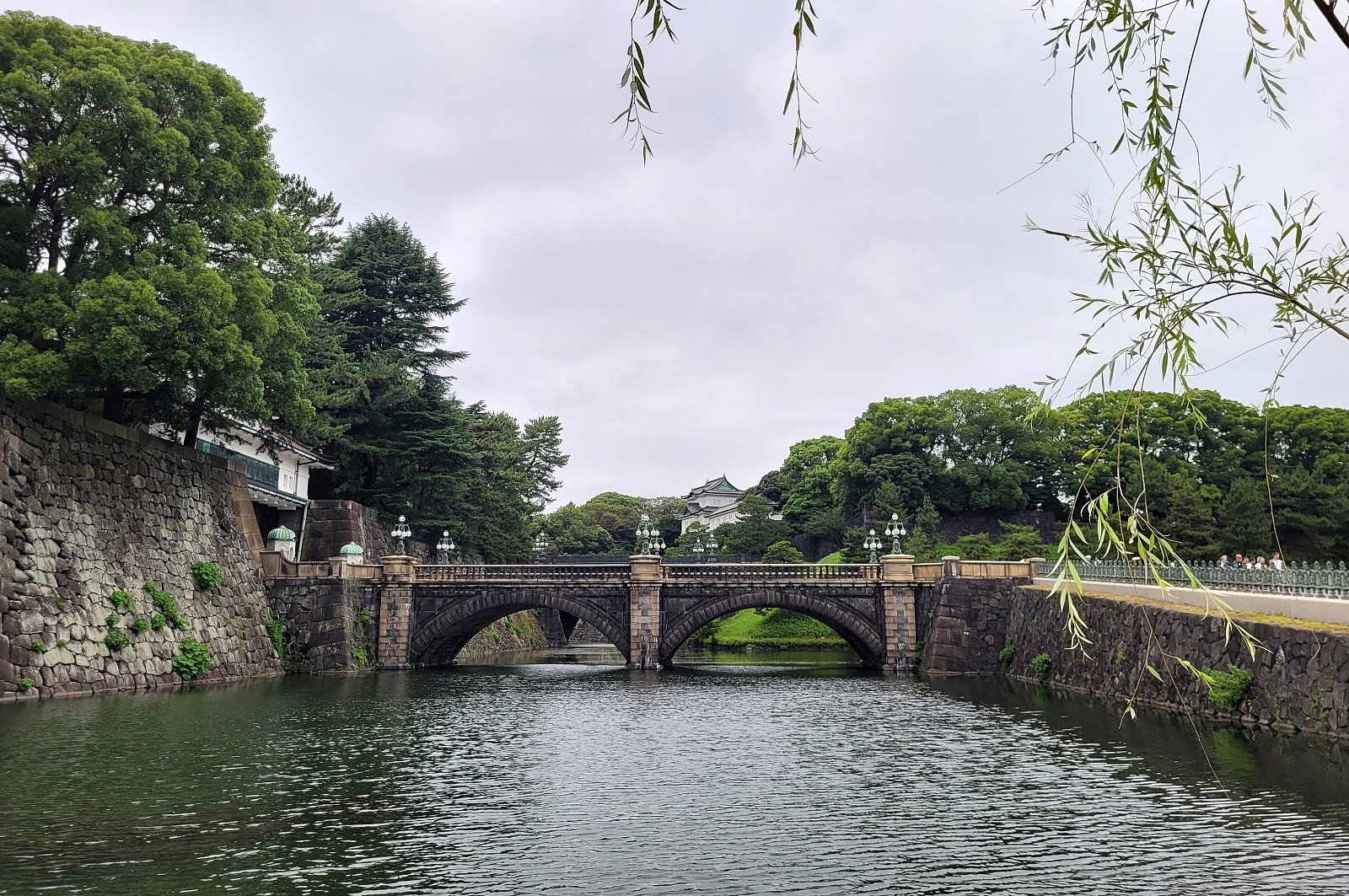 We had still some time before our flights back to Europe and thus made an attempt to see the Imperial Palace in Tokyo. Apparently, however, we seemingly had looked up the wrong information ahead of time -- just to find out that the very Palace was closed. We thus decided to walk around the Palace area, which also turned out as an interesting walk. With even more time left, we then added a short extra-loop to get an impression of Kanda, just north of the main railway station of Tokyo. Clearly, Tokyo has a lot variety to offer! :-)
Selected photos are available as Google photo album .
See also the related FB-page Hiking around Bergen, Norway .
We had still some time before our flights back to Europe and thus made an attempt to see the Imperial Palace in Tokyo. Apparently, however, we seemingly had looked up the wrong information ahead of time -- just to find out that the very Palace was closed. We thus decided to walk around the Palace area, which also turned out as an interesting walk. With even more time left, we then added a short extra-loop to get an impression of Kanda, just north of the main railway station of Tokyo. Clearly, Tokyo has a lot variety to offer! :-)
Selected photos are available as Google photo album .
See also the related FB-page Hiking around Bergen, Norway .
Visiting Odaiba beach to see the Rainbow Bridge
- Date:
- 09.07.2025
- Characteristic:
- Walk
- Duration:
- 2:30h
- Distance:
- 3.1km
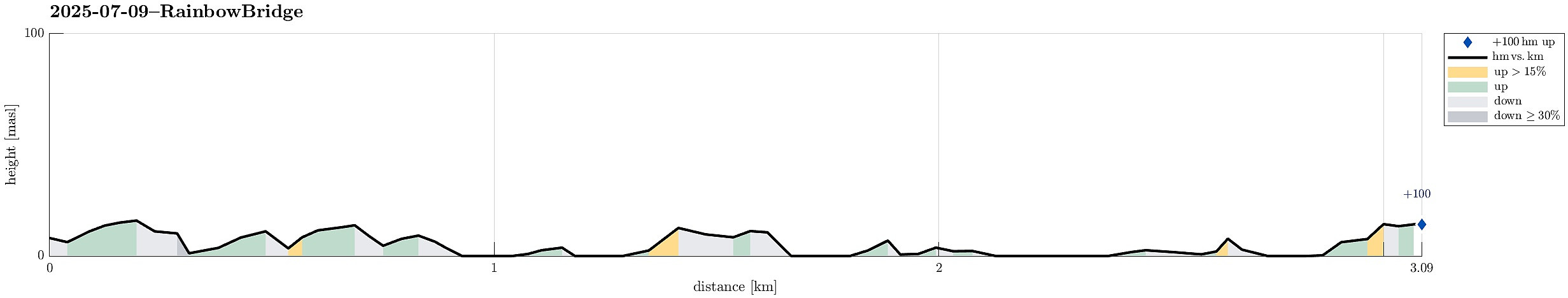 Very nice evening excursion to the Odaiba beach in Tokyo near the Rainbow Bridge. After first enjoying some nice time at the beach, we then walked around the Odaiba Marina to also see the Daiba Park on the other side, offer even more close-up views to the Rainbow Bridge (and to Tokyo behind it). While the beach was crowded -- mostly with young people in the evening -- we found ourselves 100% "alone" in the Daiba Park (after sunset). Interesting! :-)
Selected photos are available as Google photo album .
See also the related FB-page Hiking around Bergen, Norway .
Very nice evening excursion to the Odaiba beach in Tokyo near the Rainbow Bridge. After first enjoying some nice time at the beach, we then walked around the Odaiba Marina to also see the Daiba Park on the other side, offer even more close-up views to the Rainbow Bridge (and to Tokyo behind it). While the beach was crowded -- mostly with young people in the evening -- we found ourselves 100% "alone" in the Daiba Park (after sunset). Interesting! :-)
Selected photos are available as Google photo album .
See also the related FB-page Hiking around Bergen, Norway .
Meiji Temple
- Date:
- 05.07.2025
- Characteristic:
- Walk
- Duration:
- 1:30h
- Distance:
- 3.4km
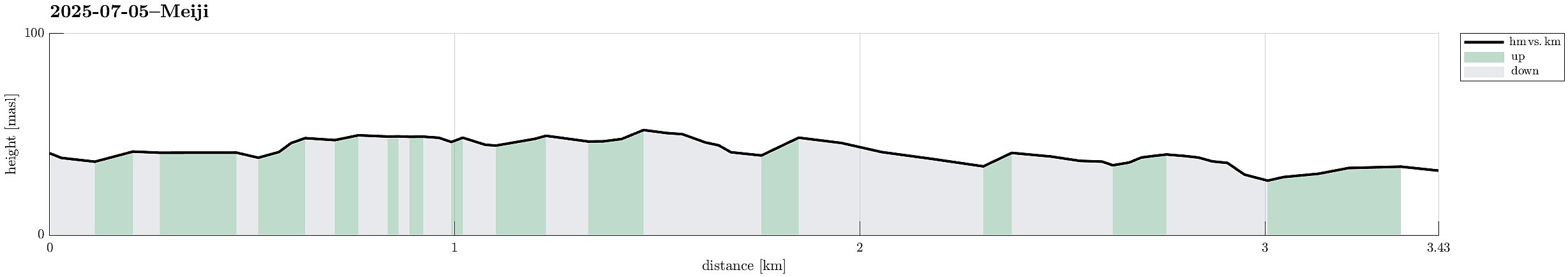 Short excursion during our visit to Tokyo with the Meiji temple and the rather crazy streets near to it! :-)
Selected photos are available as Google photo album .
See also the related FB-page Hiking around Bergen, Norway .
Short excursion during our visit to Tokyo with the Meiji temple and the rather crazy streets near to it! :-)
Selected photos are available as Google photo album .
See also the related FB-page Hiking around Bergen, Norway .
Roppongi hills and Shibuya
- Date:
- 04.07.2025
- Characteristic:
- Walk
- Duration:
- 4:30h
- Distance:
- 5.6km
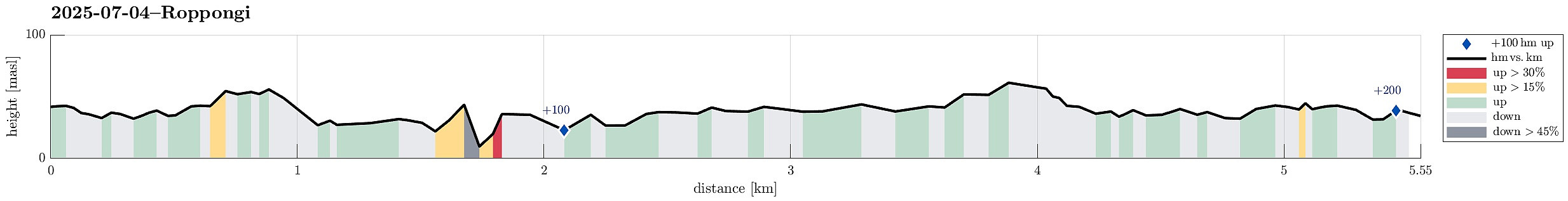 On our first full day in Tokyo, we decided to first visit Roppongi hills (and a very nice exhibition in the Mori Art Musuem, there). From there, we then chose to walk over to Shibuya to experience the famous Shibuya crossing in the evening. In in fact got to see it twice (actually three times), once before the rain, and then again during the rain. The packing density varied clearly, without dropping to any low value, though. :-)
Selected photos are available as Google photo album .
See also the related FB-page Hiking around Bergen, Norway .
On our first full day in Tokyo, we decided to first visit Roppongi hills (and a very nice exhibition in the Mori Art Musuem, there). From there, we then chose to walk over to Shibuya to experience the famous Shibuya crossing in the evening. In in fact got to see it twice (actually three times), once before the rain, and then again during the rain. The packing density varied clearly, without dropping to any low value, though. :-)
Selected photos are available as Google photo album .
See also the related FB-page Hiking around Bergen, Norway .
Evening visit to the Shiratani Unsui Gorge
- Date:
- 02.07.2025
- Characteristic:
- Hillwalk
- Duration:
- 1:00h
- Distance:
- 3.3km
 There was still a bit of daylight time left -- we thus drove up to the Shiratani Unsui Gorge to have one relatively quick look. In principle, one could start from this place to extensive hikes, but given the relatively short time left, we only walked around the gorge for short while. Clearly, experiencing the jungle in the evening is also something very special! :-)
Selected photos are available as Google photo album .
See also the related FB-page Hiking around Bergen, Norway .
There was still a bit of daylight time left -- we thus drove up to the Shiratani Unsui Gorge to have one relatively quick look. In principle, one could start from this place to extensive hikes, but given the relatively short time left, we only walked around the gorge for short while. Clearly, experiencing the jungle in the evening is also something very special! :-)
Selected photos are available as Google photo album .
See also the related FB-page Hiking around Bergen, Norway .
