Archive - Date
Archive - Activity
-
Bike trip (137)
- Bike trip - mixed (51)
- Bike trip - road (9)
-
Other trip (1)
- Kayaking (1)
-
Other winter trip (4)
- Snowshoe trip (4)
- Ski trip (4)
- Trip by foot (740)
Archive - Geography
Peakbook-Friends


Collected lists
-
Bergen ≥ 50m pf. og ≥ 100 m.o.h.
(87/89)
 97%
97% -
Most dominating tops of the Bergen peninsula
(68/75)
90%
-
Utvalgte topper og turmål i Bergen
(316/350)
90%
-
Alle topper i Bergen
(357/398)
89%
-
Opptur Bergen
(100/113)
88%
-
De syv fjell rundt Bergen
(6/7)
85%
-
Sund ≥ 50m pf.
(14/18)
77%
-
Os ≥ 50m pf.
(25/34)
73%
-
Søyler (fastmerker) i Bergen
(68/100)
68%
-
Fjell ≥ 50m pf.
(21/32)
65%

Vassberget, Kvamsfjellet, and Tveitavarden
- Date:
- 28.02.2026
- Characteristic:
- Hike
- Duration:
- 4:00h
- Distance:
- 10.0km
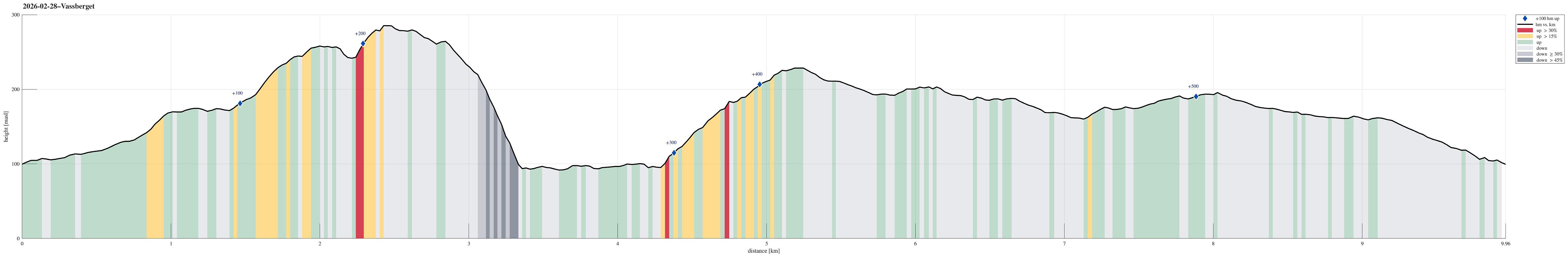 We expected a nice day and wished to make a nice, moderate hike with a chance to catch some sun, also. After first looking at Tveitavarden, Kvamsfjellet, and Vassberget, north of Knarvik, we then found a description of a hike over these hills, but in reverse order, providing additional motivation to explore this part of Alver. After driving there from Bergen, we parked right next to Lindåsvegen, where Årdalen comes down from the northwest. Walking up Årdalen, we then found the trail head for Vassberget, which is nicely marked with a sign. Following this trail, we quickly made it up the ridge in the southwest of Kråkstidalen, but instead of crossing over this valley (as the main trail does), we continued further northwards on the ridge (into the direction of Litlevassberget). At times and with some phantasy, >>>
Nice round around Småvatnet near Alvøen
- Date:
- 21.02.2026
- Characteristic:
- Walk
- Duration:
- 2:00h
- Distance:
- 6.6km
 There was an idea of spring in the air and so we decided to make a round around Småvatnet near Alvøen. We parked in the north, right next to Alvøveien, not far from the soccer fields there. To get south towards Småvatnet, we first crossed over Ospehaugen. Further south, we then started our round around the lake by exploring the small peninsular in the west of Slettebakksvika. Next was then to walk around Slettebakksvika and heading further south on the east-side of Småvatnet. This stretch is a bit interesting, since one has to find a way to get through (with quite some cliffs connecting more or less directly to Småvatnet). Since we had done this before, we knew that it could be done, and so it was without difficulties that we made it to Gullaksdalen. From there, we then followed >>>
Skiing Bildøybakken
- Date:
- 14.02.2026
- Characteristic:
- Backcountry skiing
- Duration:
- 2:00h
- Distance:
- 5.2km
 With new snow outside, we decided to take our skies and head towards Bildøybakken for an excursion into the snow. We parked at the lower end of the road which leads up to the dam of Bildøyvatnet, then following this road up to the dam. From there, we then ascended to Bildøyfjellet. Then, we continued across the heights of Bildøybakken (southwards to Vardafjellet). We then decided to connect to the southern end of Bildøyvatnet in order to cross it (on skies) south-to-north. This worked just fine and it did not take us all to long before we were back where we had started the afternoon.
Selected photos are available as Google photo album .
See also the related FB-page Hiking around Bergen, Norway .
With new snow outside, we decided to take our skies and head towards Bildøybakken for an excursion into the snow. We parked at the lower end of the road which leads up to the dam of Bildøyvatnet, then following this road up to the dam. From there, we then ascended to Bildøyfjellet. Then, we continued across the heights of Bildøybakken (southwards to Vardafjellet). We then decided to connect to the southern end of Bildøyvatnet in order to cross it (on skies) south-to-north. This worked just fine and it did not take us all to long before we were back where we had started the afternoon.
Selected photos are available as Google photo album .
See also the related FB-page Hiking around Bergen, Norway .
Marmorøyen, Flatøyna, and Ulvøyna
- Date:
- 08.02.2026
- Characteristic:
- Hillwalk
- Duration:
- 1:30h
- Distance:
- 5.0km
 With everthing still frozen, we thought that it could work to simply walk over to Marmorøyen in Nordåsvatnet. We parked near Troldhaugen and approached the ice via Frants Beyers veg. While the ice on top of Nordåsvatnet indeed was thick and sturdy, it wasn't all trivial to get onto it -- due to the tides, the ice was broken up near the shore. One attempt to get onto the ice right at the beginning then ended up with breaking into the water right away (just with one leg). After finding a better spot, it then worked without problems. This little mishap in the beginning, however, resulted in the decimation of the walking team (from three down to two). Once on the ice, the next question was where a good "landing place" would be on Marmorøyen. Heading a bit outwards of Marmorsundet >>>
Ørnahaugen, then back across Gjeddevatnet
- Date:
- 01.02.2026
- Characteristic:
- Hillwalk
- Duration:
- 2:00h
- Distance:
- 5.9km
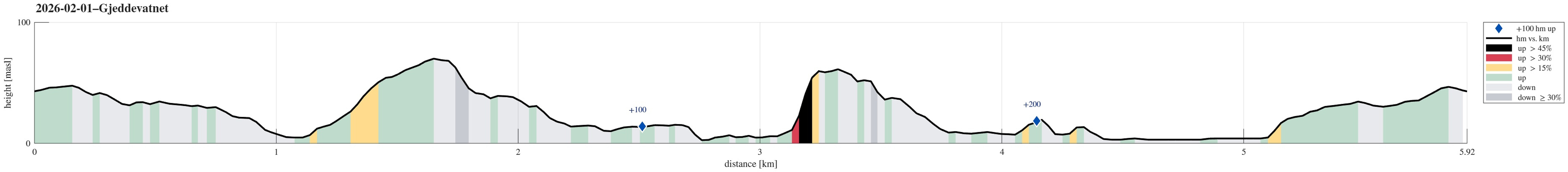 Yet again we just wished to go for a short walk. We started into the direction of Knappen, but decided to aim northwards, instead, this time. Just walking along the streets around Bjørgedalen, we made it to Kjerreidvika. We then thought that we could use the wintery conditions to ascend to Ørnahaugen via its steep southeastern side. This worked out well. We then descended back down from Ørnahaugen towards the east (Sæleidet). We then thought that we could use the icy lake cover of Bjørndalsvatnet to get over to Elvareidet without disturbing the people living there. On the other side, we first tried to get up this rather narrow valley north of Elvareidet. Since we encountered too much ice there, however, we abandoned this plan. Instead, we then thought that it would be something >>>
