Archive - Date
Archive - Activity
-
Bike trip (137)
- Bike trip - mixed (51)
- Bike trip - road (9)
-
Other trip (1)
- Kayaking (1)
-
Other winter trip (4)
- Snowshoe trip (4)
- Ski trip (4)
- Trip by foot (740)
Archive - Geography
Peakbook-Friends


Collected lists
-
Bergen ≥ 50m pf. og ≥ 100 m.o.h.
(87/89)
 97%
97% -
Most dominating tops of the Bergen peninsula
(68/75)
90%
-
Utvalgte topper og turmål i Bergen
(316/350)
90%
-
Alle topper i Bergen
(357/398)
89%
-
Opptur Bergen
(100/113)
88%
-
De syv fjell rundt Bergen
(6/7)
85%
-
Sund ≥ 50m pf.
(14/18)
77%
-
Os ≥ 50m pf.
(25/34)
73%
-
Søyler (fastmerker) i Bergen
(68/100)
68%
-
Fjell ≥ 50m pf.
(21/32)
65%

Kanadaskogen in new snow
- Date:
- 23.11.2024
- Characteristic:
- Hike
- Duration:
- 5:00h
- Distance:
- 13.9km
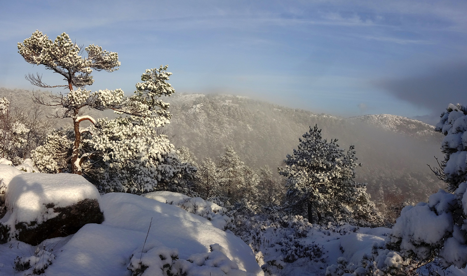 We looked forward to a quite nice day with some new snow. Instead of choosing a trip far from home, we decided to simply head into Kanadaskogen and see where it would take us. We first headed north from Varden and entered Kanadaskogen from Hesjakollen in the southeast of Litla Krokatjørna. We followed a simple trail further northwards, which brought us to the southwestern side of Stora Krokatjørna. With some low-standing sun casting light across the snow-covered landscape, we already enjoyed our excursion substantially! :-) From Stora Krokatjørna, we aimed at Storhovden as our next goal, stepping up the southern ridge of Syningen to get there. We then explored the three heights of Storhovden before continuing in northeastern direction. While first going off-trail, we eventually joined >>>
From Lyngholm to Ryvarden
- Date:
- 16.11.2024
- Characteristic:
- Hillwalk
- Duration:
- 3:00h
- Distance:
- 6.7km
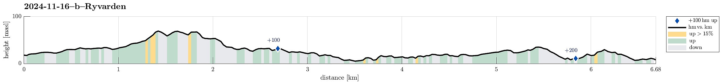 We left one car at the parking lot for Ryvarden in Mølstrevåg, while driving with the other one to Lyngholm a bit further north. There, we found a place, where we could leave the car for 20 NOK. There, we started our hike, following the well-marked North Sea Trail (Nordsjøløypa). Right in the beginning, the weather was a bit rough (strong wind, a bit of rain) -- a bit later, though, it improved and approaching Landsåt, we even got to imagine the sun for some moments! :-) The rather wild weather, however, made walking this trail an interesting experience. Especially the hail showers, which hit us with quite some force due to the strong wind, made sure that we experienced a special kind of presence. :-) Even though the first roughly three kilometers not really are right at the sea, >>>
Morning round on Ryvardsneset
- Date:
- 16.11.2024
- Characteristic:
- Hillwalk
- Duration:
- 1:30h
- Distance:
- 3.9km
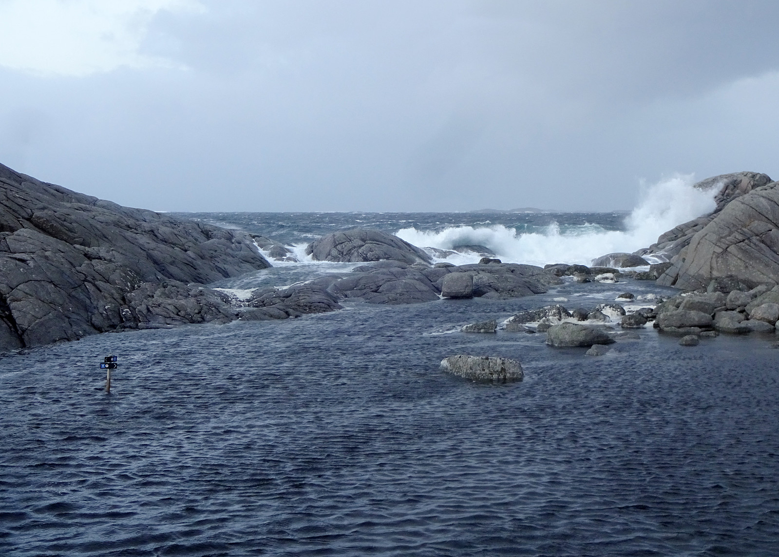 We were staying in one of Flokehyttene on Ryvardsneset and given the rather strong winds the circumstances for easily sleeping into the Saturday were not ideal anyway -- instead, it was much better to get out into the wind and make an attempt to use a rain-free period for a stroll around Ryvardsneset. First, we took the few steps out to the light house at Ryvarden. With all the rather strong winds, it was clearly an impressive experience (and walking down to Huldrahola was by no means a viable option). Next, we visited the commemoration monument for the Sleipner tragedy a bit north of Ryvarden in 1999. Even though breakfast was tempting a real lot, already, there still seemed to be a good opportunity for including a short trail along the southern coast of Ryvardsneset. This trail, when >>>
Valesåta, Trollevassnibba, Monsvarden, Målefjellet
- Date:
- 15.11.2024
- Characteristic:
- Hike
- Duration:
- 4:00h
- Distance:
- 8.9km
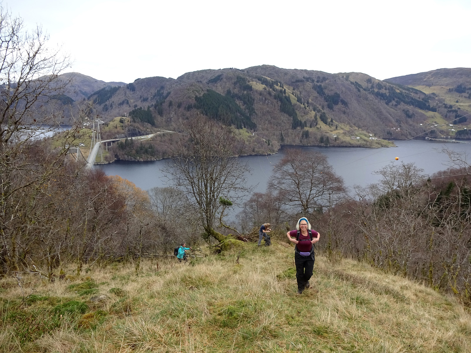
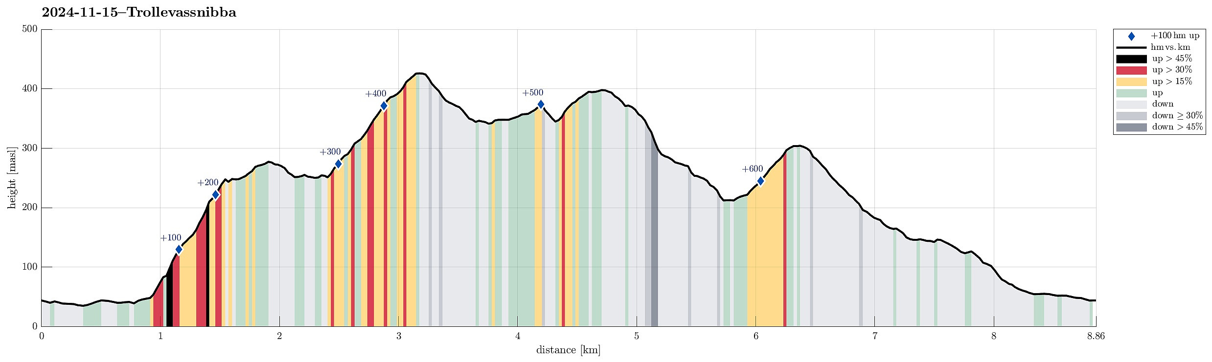 We had left Bergen early on this Friday to still use some daylight time for a hike on Sveio. Right after using the under sea tunnel from Stord, we turned onto Tittelsnesvegen (in a way to head "back" north, but now above the tunnel). Near Valevåg Camping (on the left side of the street) we found a spot to park (on the right side of the street) and started our hike from there. We first continued along Tittelsnesvegen northwards, passing by Valevåg Camping on the left, until we came to the place, where Tittelsnesvegen forks off to the right. Following now this part of Tittelsnesvegen for about two thirds of a kilometer, we got to the trail head on the right of the road. From there, we used a well-marked trail relatively steeply upwards to get up to a ridge in the south of Valesåta. >>>
Herlandsfjellet from Herland
- Date:
- 09.11.2024
- Characteristic:
- Hike
- Duration:
- 4:30h
- Distance:
- 9.8km
 We had this one day and wished to do a nice hike with approximately 800 height meters. We took inspiration from an earlier approach to Herlandsfjellet and aimed at repeating the same ascent from Herland. Again, we parked near the bridge to Osterøy. We then "went around" to get to the southern side of E16, following Romslovegen for a short stretch (and over E16). On the other side, we followed a short side road that would bring us to the actual starting point of the ascent right next to Kjerringaelva. As last time, we followed the ridge between Holebekken in the west and Kjerringaelva in the east to find our way up to Saurinden. This is a steep ascent, but the terrain is easy to traverse. Once above 150masl, it's no longer "very steep", and then above 300masl it's basically a gentle slope upwards. The >>>
Lund city walk
- Date:
- 05.11.2024
- Characteristic:
- Walk
- Duration:
- 2:00h
- Distance:
- 7.0km
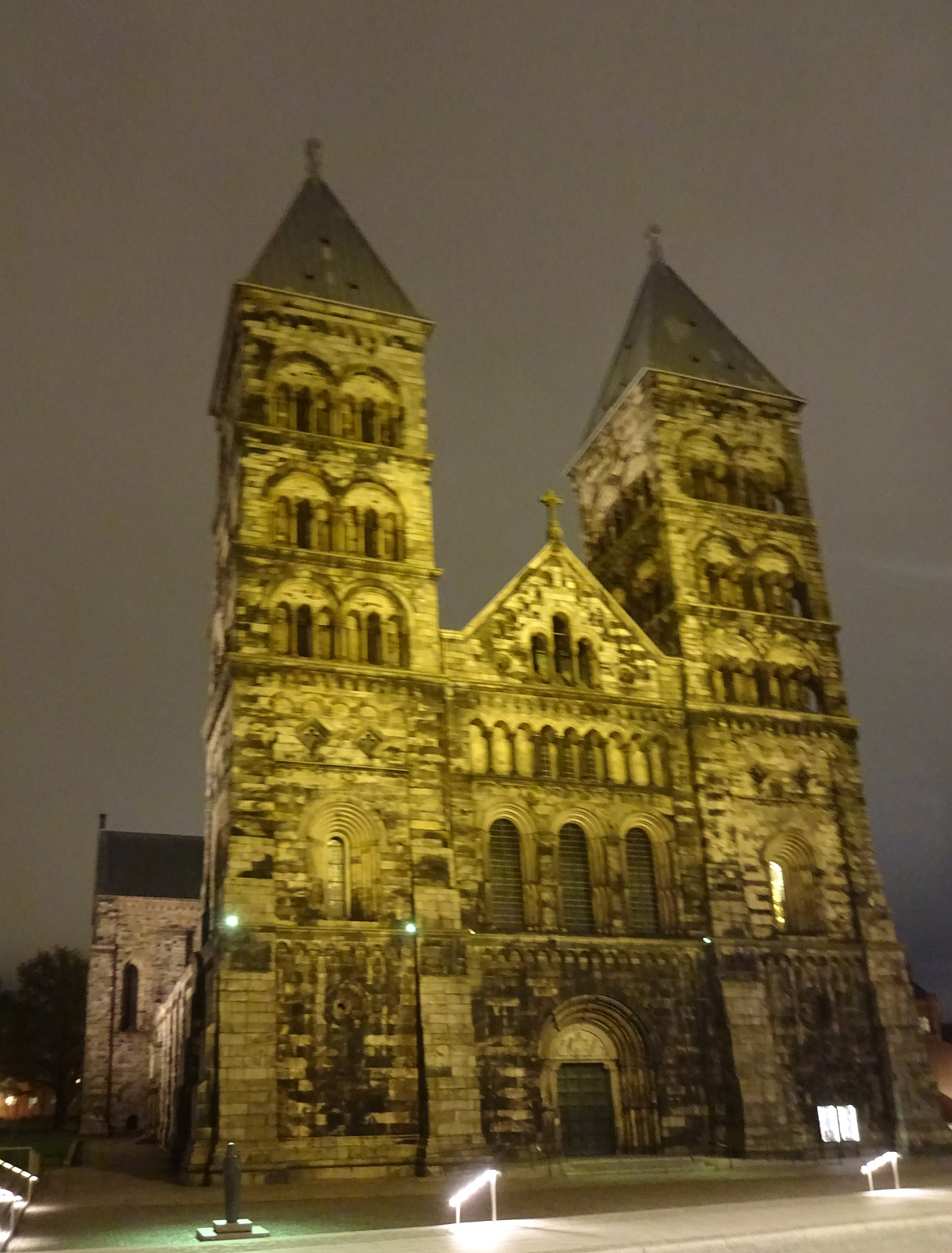 I had to visit Lund and decided to use some evening time for a short city walk. Starting from the main train station in Lund, I first headed into Lilla Fiskaregatan. After crossing Stortorget into Skomakaregatan, I "circled back" to Lunds domkyrka. I then headed north along Kyrkogatan and Bredgatan, before following Getingevägen to IDEON Science Park. From there, I eventually walked back to the main train station, heading towards the Botanical garden, first, before then turning west and towards the train station. Given that all this was done in the dark, I only got an approximate impression of Lund, this time.
See also the related FB-page Hiking around Bergen, Norway .
I had to visit Lund and decided to use some evening time for a short city walk. Starting from the main train station in Lund, I first headed into Lilla Fiskaregatan. After crossing Stortorget into Skomakaregatan, I "circled back" to Lunds domkyrka. I then headed north along Kyrkogatan and Bredgatan, before following Getingevägen to IDEON Science Park. From there, I eventually walked back to the main train station, heading towards the Botanical garden, first, before then turning west and towards the train station. Given that all this was done in the dark, I only got an approximate impression of Lund, this time.
See also the related FB-page Hiking around Bergen, Norway .
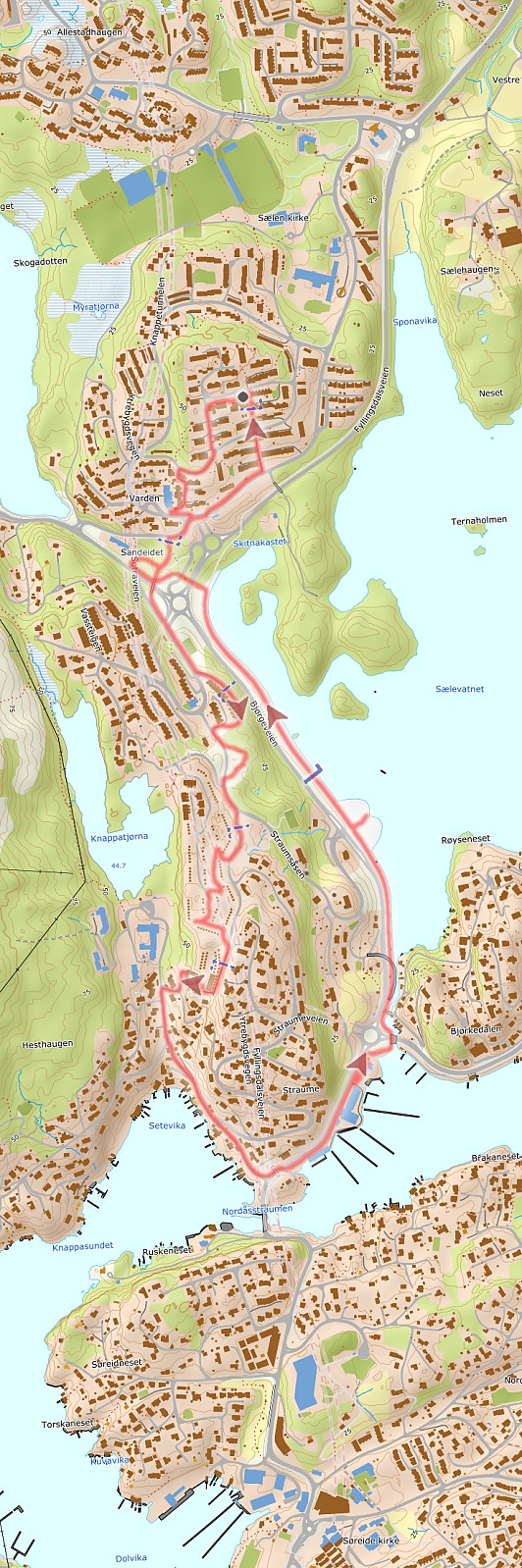
Cycling around Nordåsvatnet
- Date:
- 03.11.2024
- Characteristic:
- Bike trip - road
- Duration:
- 2:30h
- Distance:
- 25.0km
 After changing to spikes on our bikes, we wished to bike one round to see that everything works well. Lacking a more creative idea, we decided to simply bike once around Nordåsvatnet. While we did get quite a bit wet, we still returned satisfied after a bit of work-out...
See also the related FB-page Hiking around Bergen, Norway .
After changing to spikes on our bikes, we wished to bike one round to see that everything works well. Lacking a more creative idea, we decided to simply bike once around Nordåsvatnet. While we did get quite a bit wet, we still returned satisfied after a bit of work-out...
See also the related FB-page Hiking around Bergen, Norway .
Traudalen
- Date:
- 02.11.2024
- Characteristic:
- Bike trip - road
- Duration:
- 1:00h
- Distance:
- 8.6km
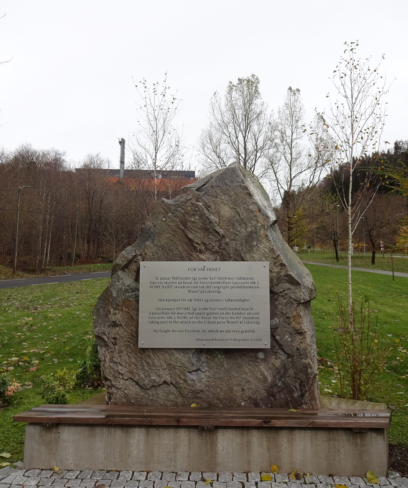 Instead of biking directly to the shop, I decided to make a little detour towards upper Fyllingsdalen. Before the rain started, I took a look at the place, where in 2020 a stone was erected in memory of three British soldiers, who had jumped out of their aircraft on January 12, 1945, then coming down on parachutes, before eventually being captured and detained. First, I had considered to include also a short hike up to Løvstakken, but since it already started to rain, my motivation degraded and I instead returned back towards more southern grounds in Fyllingsdalen (and to the shop, of course).
Selected photos are available as Google photo album .
See also the related FB-page Hiking around Bergen, Norway .
Instead of biking directly to the shop, I decided to make a little detour towards upper Fyllingsdalen. Before the rain started, I took a look at the place, where in 2020 a stone was erected in memory of three British soldiers, who had jumped out of their aircraft on January 12, 1945, then coming down on parachutes, before eventually being captured and detained. First, I had considered to include also a short hike up to Løvstakken, but since it already started to rain, my motivation degraded and I instead returned back towards more southern grounds in Fyllingsdalen (and to the shop, of course).
Selected photos are available as Google photo album .
See also the related FB-page Hiking around Bergen, Norway .
Friday evening walk along Sælevatnet
- Date:
- 01.11.2024
- Characteristic:
- Walk
- Duration:
- 1:30h
- Distance:
- 5.1km
 Just a Friday evening walk in the neighborhood to stretch our feet and get some fresh air. Simple, nice. :-)
See also the related FB-page Hiking around Bergen, Norway .
Just a Friday evening walk in the neighborhood to stretch our feet and get some fresh air. Simple, nice. :-)
See also the related FB-page Hiking around Bergen, Norway .
