Archive - Date
Archive - Activity
-
Bike trip (137)
- Bike trip - mixed (51)
- Bike trip - road (9)
-
Other trip (1)
- Kayaking (1)
-
Other winter trip (4)
- Snowshoe trip (4)
- Ski trip (4)
- Trip by foot (740)
Archive - Geography
Peakbook-Friends


Collected lists
-
Bergen ≥ 50m pf. og ≥ 100 m.o.h.
(87/89)
 97%
97% -
Most dominating tops of the Bergen peninsula
(68/75)
90%
-
Utvalgte topper og turmål i Bergen
(316/350)
90%
-
Alle topper i Bergen
(357/398)
89%
-
Opptur Bergen
(100/113)
88%
-
De syv fjell rundt Bergen
(6/7)
85%
-
Sund ≥ 50m pf.
(14/18)
77%
-
Os ≥ 50m pf.
(25/34)
73%
-
Søyler (fastmerker) i Bergen
(68/100)
68%
-
Fjell ≥ 50m pf.
(21/32)
65%

Gulltjørna from Risnes
- Date:
- 18.06.2023
- Characteristic:
- Hike
- Duration:
- 3:00h
- Distance:
- 6.6km
 We liked the idea to paying Gulltjørna another visit and we also liked the idea to do it, again, from the north. Following E16 into the east of Bergen, we left the main road near Romslo in order to connect to the old, narrow road that would bring us closer to Risnes. We found a spot where we could park alongside the road just a short stretch before actually getting all the way to Risnes. From there, we walked first for a short stretch along the road in order to get to our starting point of the actual hike. Right next to the bridge over the stream that comes down there through Risnes, we saw that one could use the steps of the water processing building there to get a bit further up (and away from the road). Where the stairs end, however, one needs to revert to actual hiking (there it's >>>
Biking around Hordnesskogen
- Date:
- 17.06.2023
- Characteristic:
- Bike trip - mixed
- Duration:
- 2:00h
- Distance:
- 31.8km
 With also the other bike repaired, we headed for a new biking-round around Nordåsvatnet. Again, we started our joint ride near the light rail station at Kristianborg, heading south (into the direction of Nesttun). This time, we surrounded Kristianborgvannet on the other, eastern side, though. Following the main bike route southwards, we eventually ended up in Rådalen. There, we decided that we would bike around Hordnesskogen in its south. Afte first following Rådalen further south (to the north of the school at Stend), we then turned right and onto Hordesvegen. Near house #202 along Hordnesvegen, we then came to a parking opportunity for those, who wish to start into Hordnesskogen from the south there. There, we headed into Hordnesskogen (in northwestern direction) for a few hundred >>>
Round around Ono
- Date:
- 04.06.2023
- Characteristic:
- Hike
- Duration:
- 3:00h
- Distance:
- 9.3km
 While checking for new places in Øygarden that we had not visited so far, we found Ono and decided to make a hike there. After driving first westwards out of Bergen (towards Sotra), we then turned right (in northern direction) near Kolltveit, following then road #561. At Rong, we then turned left (westwards, again) in order to get over to Ono (passing the school of Rong along Svartevikvegen). After crossing two small bridges, we had arrived at Ono. There, we parked "at once" next to the road Onevegen. The southern part of Ono is well marked for hikers -- especially those, who wish to visit Dethloffhytta in the southwest of Ono. We followed first this main trail (in southwestern direction) until we crossed over the inner end of Stekkane. On the other, southern side, we then >>>
Biking around Nordåsvatnet
- Date:
- 03.06.2023
- Characteristic:
- Bike trip - mixed
- Duration:
- 2:00h
- Distance:
- 25.0km
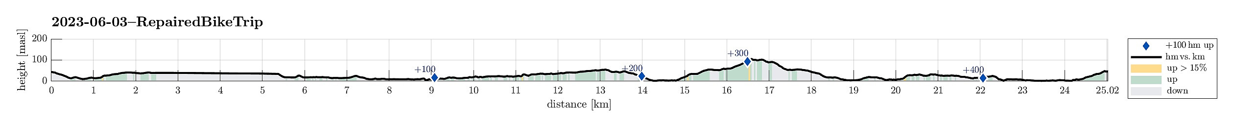 We had a bike to pick up and wished to ride a little round -- not at the least to also see that it was functioning as well as expected. We started the joint ride at the bike shop near the light rail station at Kristianborg, heading first southwards along Kanalveien and then following the track of the no longer existing railway into the direction of Nesttun. At the church of Skjold, we then turned right and cycled down to Skjoldbukta along Harald Skjolds veg. From there, we then cycled up to Nordåsvegen, which we then followed "all around" Nordåsen. On the south, we then descended to Steinsvikvegen. Following Steinsvikvegen around Steinsviken and Søviken, we connected to Søreide and from there further northwards to Sandeidet. All in all, a nice bike ride! :-)
See also the >>>
We had a bike to pick up and wished to ride a little round -- not at the least to also see that it was functioning as well as expected. We started the joint ride at the bike shop near the light rail station at Kristianborg, heading first southwards along Kanalveien and then following the track of the no longer existing railway into the direction of Nesttun. At the church of Skjold, we then turned right and cycled down to Skjoldbukta along Harald Skjolds veg. From there, we then cycled up to Nordåsvegen, which we then followed "all around" Nordåsen. On the south, we then descended to Steinsvikvegen. Following Steinsvikvegen around Steinsviken and Søviken, we connected to Søreide and from there further northwards to Sandeidet. All in all, a nice bike ride! :-)
See also the >>>
