Archive - Date
Archive - Activity
-
Bike trip (137)
- Bike trip - mixed (51)
- Bike trip - road (9)
-
Other trip (1)
- Kayaking (1)
-
Other winter trip (4)
- Snowshoe trip (4)
- Ski trip (4)
- Trip by foot (740)
Archive - Geography
Peakbook-Friends


Collected lists
-
Bergen ≥ 50m pf. og ≥ 100 m.o.h.
(87/89)
 97%
97% -
Most dominating tops of the Bergen peninsula
(68/75)
90%
-
Utvalgte topper og turmål i Bergen
(316/350)
90%
-
Alle topper i Bergen
(357/398)
89%
-
Opptur Bergen
(100/113)
88%
-
De syv fjell rundt Bergen
(6/7)
85%
-
Sund ≥ 50m pf.
(14/18)
77%
-
Os ≥ 50m pf.
(25/34)
73%
-
Søyler (fastmerker) i Bergen
(68/100)
68%
-
Fjell ≥ 50m pf.
(21/32)
65%

Exploring snowy Brandset
- Date:
- 31.12.2022
- Characteristic:
- Snowshoe trip
- Duration:
- 2:00h
- Distance:
- 5.2km
 Nice excursion into the snow (with snow shoes) on the last day in the year. While the snow shoes helped a lot, it was still quite an effort through the deep snow -- definitely worth it! :-)
Selected photos are available as Google photo album .
See also the related FB-page Hiking around Bergen, Norway .
Nice excursion into the snow (with snow shoes) on the last day in the year. While the snow shoes helped a lot, it was still quite an effort through the deep snow -- definitely worth it! :-)
Selected photos are available as Google photo album .
See also the related FB-page Hiking around Bergen, Norway .
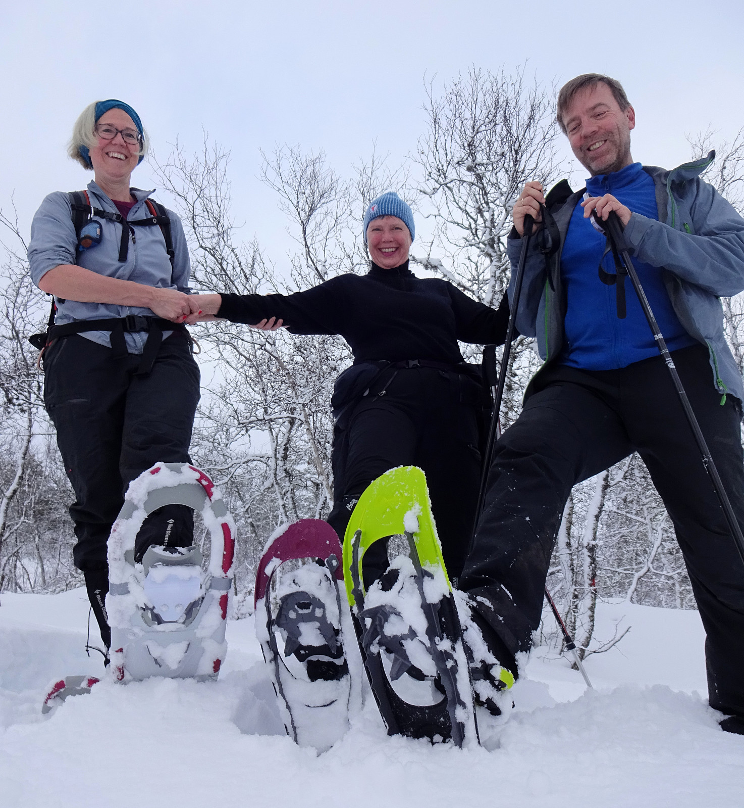
xMas hike to Fyllingsnipa
- Date:
- 24.12.2022
- Characteristic:
- Hike
- Duration:
- 1:30h
- Distance:
- 5.2km
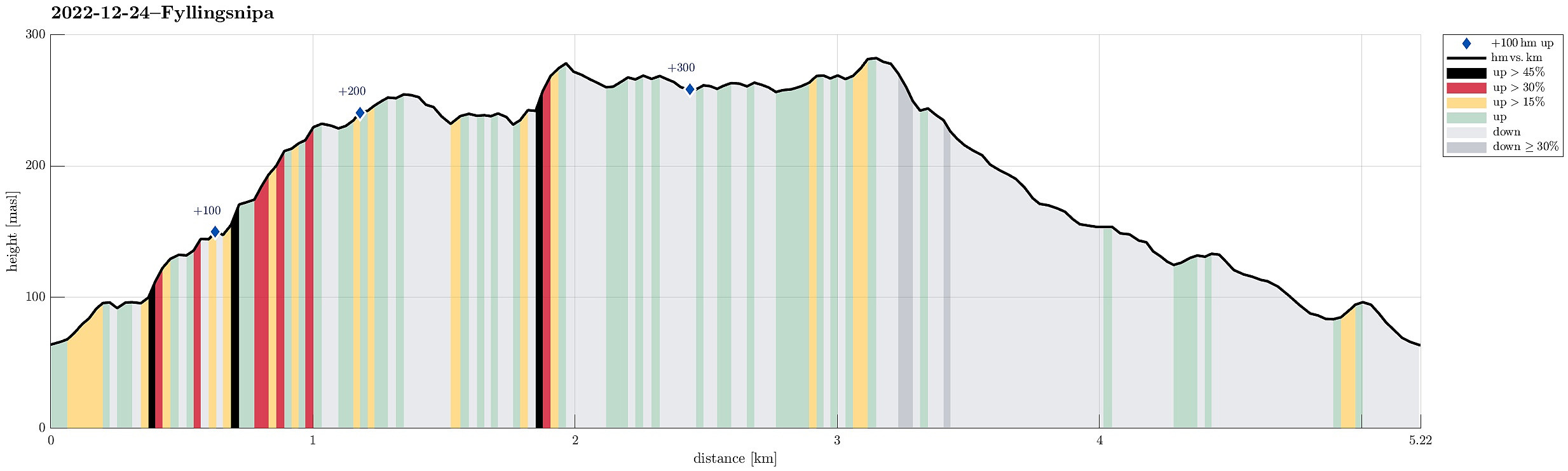 We started from the parking place at the northern end of Spelhaugen, heading for Eikelifjellet, first. Once across Eikelifjellet, we decided that it was the right day for exploring Fyllingsnipa -- a hill that we usually just pass by. To get there, we crossed over the valley in the east of Eikelifjellet a bit northwest of Tøshaugen, then ascending up to Fyllingsnipa from its south (this ascent is well possible, but a bit steep at times). From Fyllingsnipa, we then continued further northwards, passing by Nipetjørna on its western side. This brought us to a side-top of Lyngbønipa, where we had a good overview of Nipedalen and further towards the west. Thereafter, we just returned back to our car, taking a different route back (a bit further to the west).
Selected photos are available as >>>
We started from the parking place at the northern end of Spelhaugen, heading for Eikelifjellet, first. Once across Eikelifjellet, we decided that it was the right day for exploring Fyllingsnipa -- a hill that we usually just pass by. To get there, we crossed over the valley in the east of Eikelifjellet a bit northwest of Tøshaugen, then ascending up to Fyllingsnipa from its south (this ascent is well possible, but a bit steep at times). From Fyllingsnipa, we then continued further northwards, passing by Nipetjørna on its western side. This brought us to a side-top of Lyngbønipa, where we had a good overview of Nipedalen and further towards the west. Thereafter, we just returned back to our car, taking a different route back (a bit further to the west).
Selected photos are available as >>>
Random Walk in Fyllingsdalen
- Date:
- 18.12.2022
- Characteristic:
- Walk
- Duration:
- 2:00h
- Distance:
- 8.4km
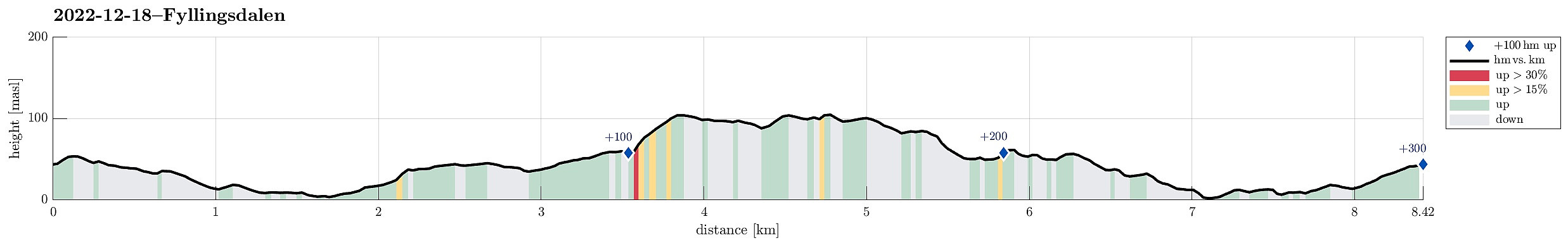 Just a "random walk" in Fyllingsdalen -- no more to write! :-)
See also the related FB-page Hiking around Bergen, Norway .
Just a "random walk" in Fyllingsdalen -- no more to write! :-)
See also the related FB-page Hiking around Bergen, Norway .
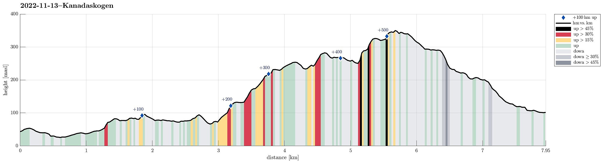
Snowy Kanadaskogen
- Date:
- 17.12.2022
- Characteristic:
- Walk
- Duration:
- 1:30h
- Distance:
- 5.8km
 Just a nice walk into snowy Kanadaskogen, visiting Langaheia in the east of Store Krokatjørna.
Selected photos are available as Google photo album .
See also the related FB-page Hiking around Bergen, Norway .
Just a nice walk into snowy Kanadaskogen, visiting Langaheia in the east of Store Krokatjørna.
Selected photos are available as Google photo album .
See also the related FB-page Hiking around Bergen, Norway .
Møsnuken from Hegglandsdalen barneskole
- Date:
- 03.12.2022
- Characteristic:
- Hike
- Duration:
- 4:00h
- Distance:
- 12.0km
 YR predicted a really nice winter day: a perfect invitation to get out! :-) Without too much comparison of all the possible nice hikes, I decided to make another attempt to ascend to Møsnuken from the southeast. I had read here on Peakbook about a trail that leads up to Tveitaberget from Hegglandsdalsvegen where it passes the primary school of Hegglandsdalen (Hegglandsdalen barneskole). And indeed there's a proper trail with a well-marked trail head next to house #528 along Hegglandsdalsvegen, which leads up along a curved ridge to Tveitaberget. According to the terrain, this trail is very steep, but just fine to step up there! :-) Once on Tveitaberget, the trail "flattens out" a little, leading then in northward direction. At about 355masl, the trail turns left to ascend steeply (for just a >>>
Hauggjelsvarden from Grimen
- Date:
- 26.11.2022
- Characteristic:
- Hike
- Duration:
- 3:30h
- Distance:
- 8.5km
 This Saturday was predicted to be the better hiking day of the weekend with clouds and some wind on the menu. The idea for the day was to ascend to Vidden from Erdalen near Grimevatnet. We started near the camping site at Grimen, crossing over Hardangervegen to get onto Erdalsvegen. After walking along Erdalsvegen for only about 200m, we turned left (exit towards the houses 12, 14, and 20), crossed the railtrack, and started our ascent into Gaulgjelet (steeply up on the eastern side of the stream). At about 125masl, we had to navigate around/over some rocks to continue in parallel to the stream. In retrospect, we got the impression that this could have been avoided by starting on the other, western side of the stream, maybe near houses 244 and 246 on Hardangervegen, and then crossing over >>>
Round around Bjørndalsvatnet
- Date:
- 20.11.2022
- Characteristic:
- Hike
- Duration:
- 2:00h
- Distance:
- 7.7km
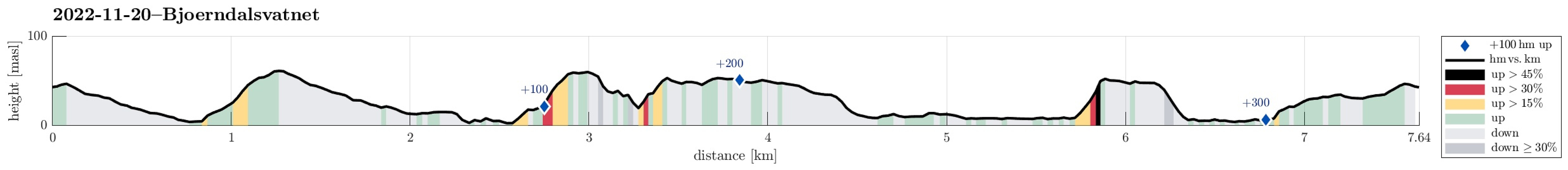 Heading for some fresh air, we decided to make a round around Bjørndalsvatnet. Starting from Varden, we first crossed over Bjørgeveien into the direction of Knappen, ascending Sandeidbrotet to reach the trail that would bring us over to Bjørgelien. Via Bjørgebrekken, we then connected to Bjørgedalen and we used the connection down to Kjerreidvika. On the other side, we ascended to Ørnahaugen, before continuing further northwards to Bjørndalsskogen. There, we crossed Bjørgeveien (again) and descended to Bjørndalsvatnet. Surrounding the lake in its north, we got to the eastern side, where we followed trails back to Varden, also passing by Gjeddevatnet after getting over between the two lakes east of Elvareidet.
Selected photos are available as Google photo album .
See also the related FB-page Hiking around Bergen, Norway .
Heading for some fresh air, we decided to make a round around Bjørndalsvatnet. Starting from Varden, we first crossed over Bjørgeveien into the direction of Knappen, ascending Sandeidbrotet to reach the trail that would bring us over to Bjørgelien. Via Bjørgebrekken, we then connected to Bjørgedalen and we used the connection down to Kjerreidvika. On the other side, we ascended to Ørnahaugen, before continuing further northwards to Bjørndalsskogen. There, we crossed Bjørgeveien (again) and descended to Bjørndalsvatnet. Surrounding the lake in its north, we got to the eastern side, where we followed trails back to Varden, also passing by Gjeddevatnet after getting over between the two lakes east of Elvareidet.
Selected photos are available as Google photo album .
See also the related FB-page Hiking around Bergen, Norway .
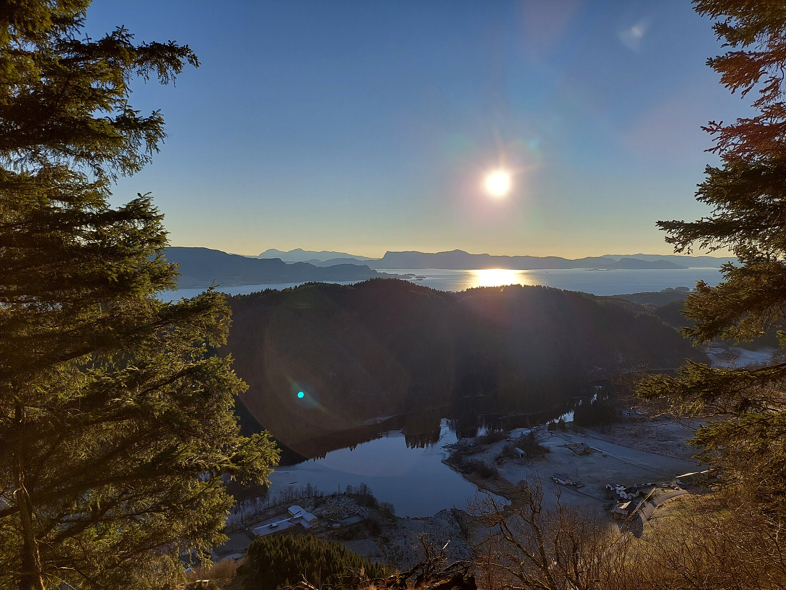
Gullfjelltoppen via Glamregjelet
- Date:
- 19.11.2022
- Characteristic:
- Hike
- Duration:
- 4:30h
- Distance:
- 11.8km
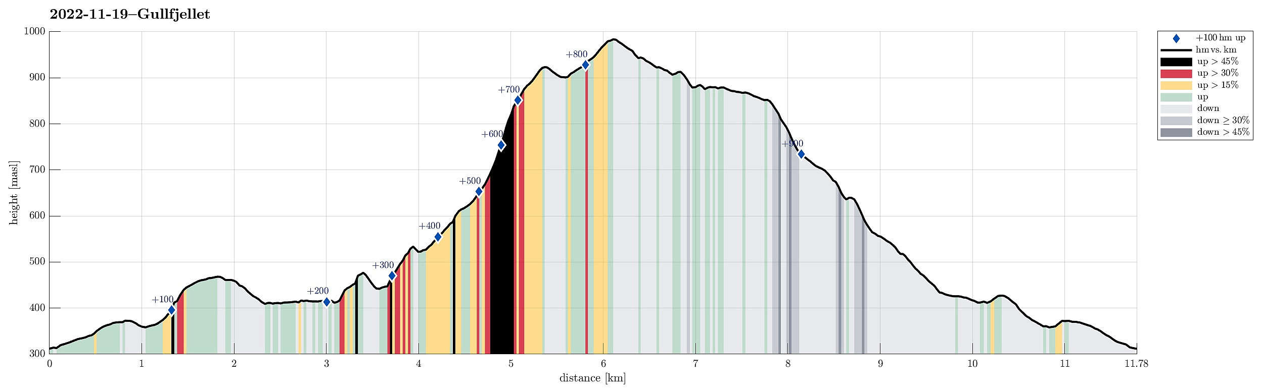 We expected a day with nice weather and decided to use it well. For a while, we had considered to ascend to Gullfjelltoppen via Glamregjelet, i.e., the valley in the northwest of Gullfjelltoppen. Assuming that the condition for exploring this route would be OK, we decided to try it. We started driving up Gullfjellsvegen to park at the parking place next to Osavatnet. From there, we first walked along the gravel road that leads up to the dam of Svartavatnet. Instead of following the "main road", which leads further up to Redningshytten, we took the convenient stairs up on the northern side of the dam, arriving close to the water level of Svartavatnet in the south of Svartavassrinden. While one of the two of us continued "horizontally", following the northwestern shore >>>
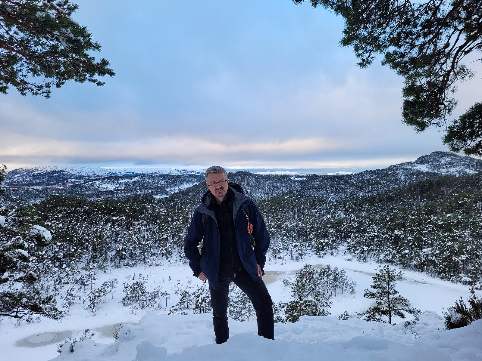
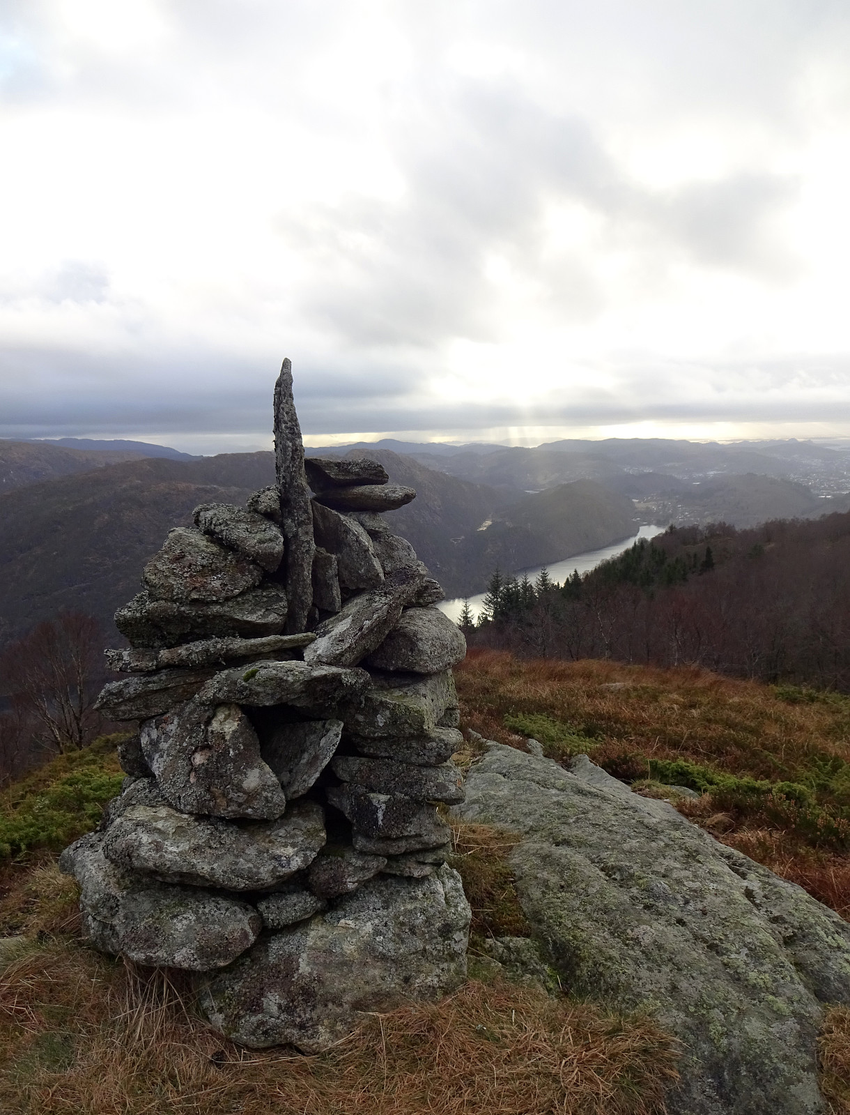
Gravdalsfjellet
- Date:
- 13.11.2022
- Characteristic:
- Hike
- Duration:
- 3:00h
- Distance:
- 8.0km
 We wished to get some fresh air and thus headed into Kanadaskogen (after first "bridging" the first few meters until we had passed by Hesjaholten). From Hesjakollen, we entered the forest (first a few meters steeply up) to cross over the small hills between Stora and Litla Krokatjørna. Passing by Spelhaugen, we continued up Mørkbotn to get to the southern end of the southern ridge of Eikelifjellet. Following this ridge, we ascended to Eikelifjellet, enjoying some nice views towards the west and southwest. From Eikelifjellet, we continued further northwards, into the direction of Nipetjørna. From there, we took two separate routes up to Gravdalsfjellet, one around the east of Nipetjørna and one around the west of it. After meeting again on Gravdalsfjellet, we started our >>>
Løvstakken via Manndomsprøven
- Date:
- 06.11.2022
- Characteristic:
- Hike
- Duration:
- 2:00h
- Distance:
- 3.3km
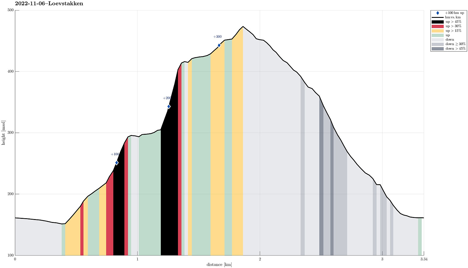 Despite of the wet weather, I saw a chance to try out something interesting: Manndomsprøven on Løvstakken (who would have thought?! :-)). In April, 2022, another user of Peakbook, Knut Sverre , described his/their ascent to Løvstakken via Manndomsprøven , a particular place on the southwestern side of Løvstakken. I got inspired already then, but hadn't had the chance to try this route before. To get there, I parked along Krohnegården, northeast of Svartatjørna, and followed first Krohnegården back southwards, passing by Svartatjørna. Once passed the rather steep western side of Nova, I crossed Krohnegården and started my ascent via Bustingen, first. A little northeast of Rosenlundveien, I connected to the trail that leads steeply up to Løvstakken from Rosenlundveien. After following this trail for a short stretch (up to about 300mosl), I deviated >>>
