Archive - Date
Archive - Activity
-
Bike trip (137)
- Bike trip - mixed (51)
- Bike trip - road (9)
-
Other trip (1)
- Kayaking (1)
-
Other winter trip (4)
- Snowshoe trip (4)
- Ski trip (4)
- Trip by foot (740)
Archive - Geography
Peakbook-Friends


Collected lists
-
Bergen ≥ 50m pf. og ≥ 100 m.o.h.
(87/89)
 97%
97% -
Most dominating tops of the Bergen peninsula
(68/75)
90%
-
Utvalgte topper og turmål i Bergen
(316/350)
90%
-
Alle topper i Bergen
(357/398)
89%
-
Opptur Bergen
(100/113)
88%
-
De syv fjell rundt Bergen
(6/7)
85%
-
Sund ≥ 50m pf.
(14/18)
77%
-
Os ≥ 50m pf.
(25/34)
73%
-
Søyler (fastmerker) i Bergen
(68/100)
68%
-
Fjell ≥ 50m pf.
(21/32)
65%

Mor Si Grav (and Bergshaugen)
- Date:
- 05.08.2020
- Characteristic:
- Hillwalk
- Duration:
- 1:30h
- Distance:
- 4.9km
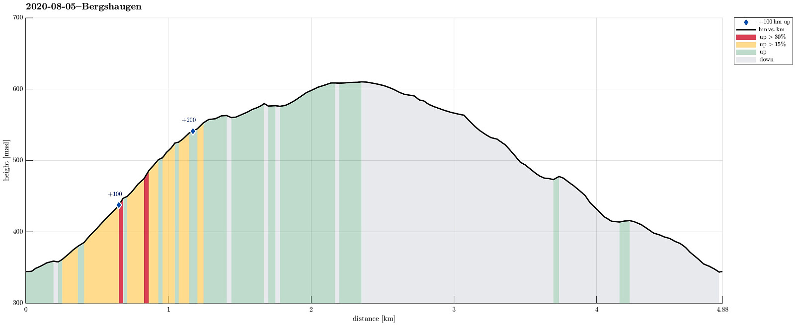 Again and again we had passed by (without stopping) before, so this time, on a rainy day, we decided to stop and take look at "Mor Si Grav" in Oppheim. We parked near the church and walked the few meters up to the old graveyard, where only "Mor Si Grav" (the mother's grave) remains. It's the place where the mother of Per Sivle is buried and an info plate not far from the grave explains some of the (quite moving!) history around it. After taking our time there, we then appended a little round around Bergshaugen, walking first up the hill and then over (at about 550mosl) to Uresåsen. From there, we then followed a gravel road (behind Bergshaugen) to Kvernhusholene. From there, we started our descent, first on the right (northern) side of Gryteelvi. At about 475mosl, >>>
Okslevarden
- Date:
- 01.08.2020
- Characteristic:
- Hike
- Duration:
- 6:00h
- Distance:
- 9.7km
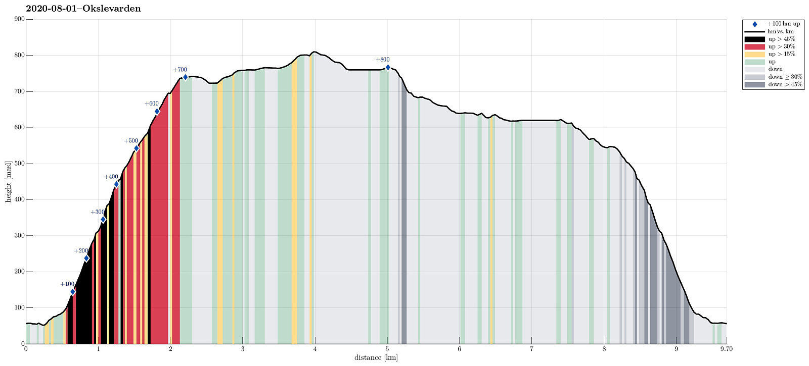 When staying over night in Haugsvær, we were recommended to ascend to Gråsida from Indre Haugsdal. So that's what we did then! :-) We drove road E39 "back" south (into the direction of Bergen) and turned right in Matre (to leave E39 before entering Masfjordtunnelen). This brought us onto the old road and following it we entered Indre Haugsdal from Haugsdalvågen. Driving up this nice valley, we came by three particular hills (in the middle of the valley), which possibly gave the valley its name. Near Kjetland we crossed the river on an old stone bridge, turning right (into the direction of Storemyr) right after the bridge. Since we did not see any particular good parking opportunity next to this narrow road, we drove all the way to Storemyr and asked there. Luckily, we were >>>
Around Hopsdalen
- Date:
- 31.07.2020
- Characteristic:
- Hike
- Duration:
- 8:30h
- Distance:
- 22.4km
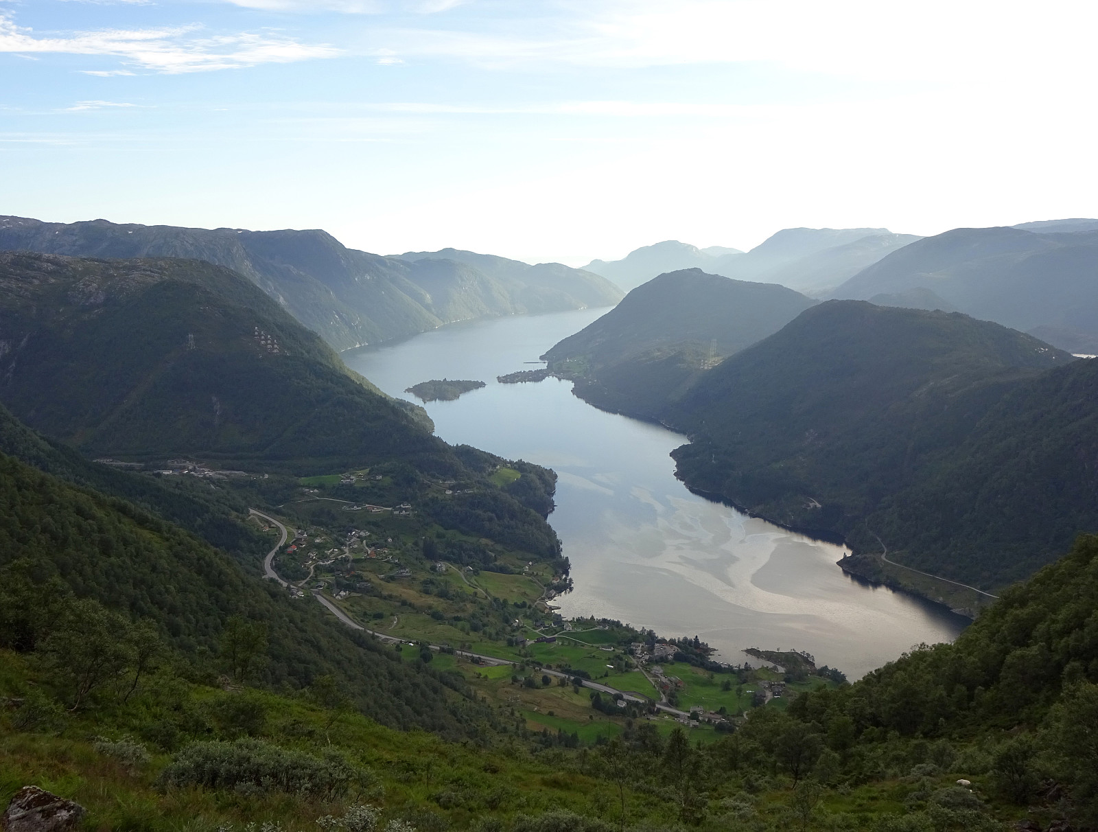 We drove along road E39 from Bergen northwards (into the direction of Masfjorden). After driving down through the long Masfjordtunnelen and passing through Matre at the very end of Matresfjorden, we crossed over to Haugsvær "behind" Nonklettfjellet. Before the main road (E39) disappears into another tunnel, we turned left in Haugsvær and parked right there.
Our (slightly ambitious) plan for the afternoon was to go around Hopsdalen (from Høgfjellet via Grønefjellet to Gavlen, and back via Rustefjellet). Considering the steep sides of Hopsdalen, we had looked at the map regarding a possible place for getting up to the top of the surrounding mountains. Near Indre Skjerjehogen, on the north side of Haugsværfjorden, we had thought that it should be possible to reach saddle Sygnegga >>>
We drove along road E39 from Bergen northwards (into the direction of Masfjorden). After driving down through the long Masfjordtunnelen and passing through Matre at the very end of Matresfjorden, we crossed over to Haugsvær "behind" Nonklettfjellet. Before the main road (E39) disappears into another tunnel, we turned left in Haugsvær and parked right there.
Our (slightly ambitious) plan for the afternoon was to go around Hopsdalen (from Høgfjellet via Grønefjellet to Gavlen, and back via Rustefjellet). Considering the steep sides of Hopsdalen, we had looked at the map regarding a possible place for getting up to the top of the surrounding mountains. Near Indre Skjerjehogen, on the north side of Haugsværfjorden, we had thought that it should be possible to reach saddle Sygnegga >>>
Nessteinen from Mundheim
- Date:
- 25.07.2020
- Characteristic:
- Hike
- Duration:
- 5:00h
- Distance:
- 8.4km
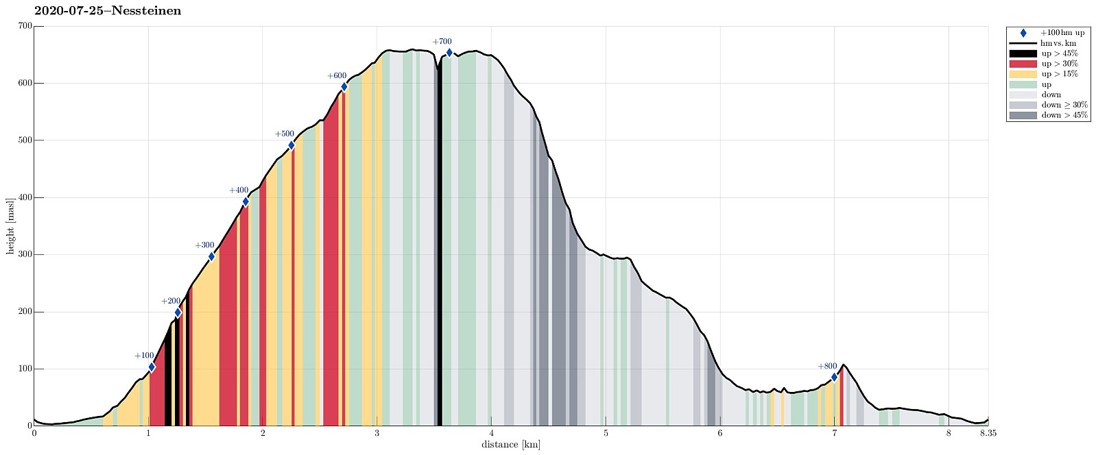 Having been "in the area", we decided to include a hike up to Nessteinen (or Steinen), expecting some nice views over Hardangerfjorden from up there. Another reason for choosing something not more extensive was the expectation of an overcast day with somewhat unstable weather. We drove the very nice road 49 from Norheimsund southwards (first around Visoldo to Strandebarm and then further southwards along Daurmålsegga to Mundheim). In Mundheim, we parked and started our hike first for a few meters northwards along road 48. At Oppheim, we crossed Storelva and walked up a simple field road to about 50mosl, where the field road meets the forest. From there, we continued along an not really used forest road, leading diagonally upwards (in eastern direction). At about 75mosl, however, >>>
Skrott and Breidablik from Fitjadalen
- Date:
- 24.07.2020
- Characteristic:
- Hike
- Duration:
- 5:30h
- Distance:
- 12.5km
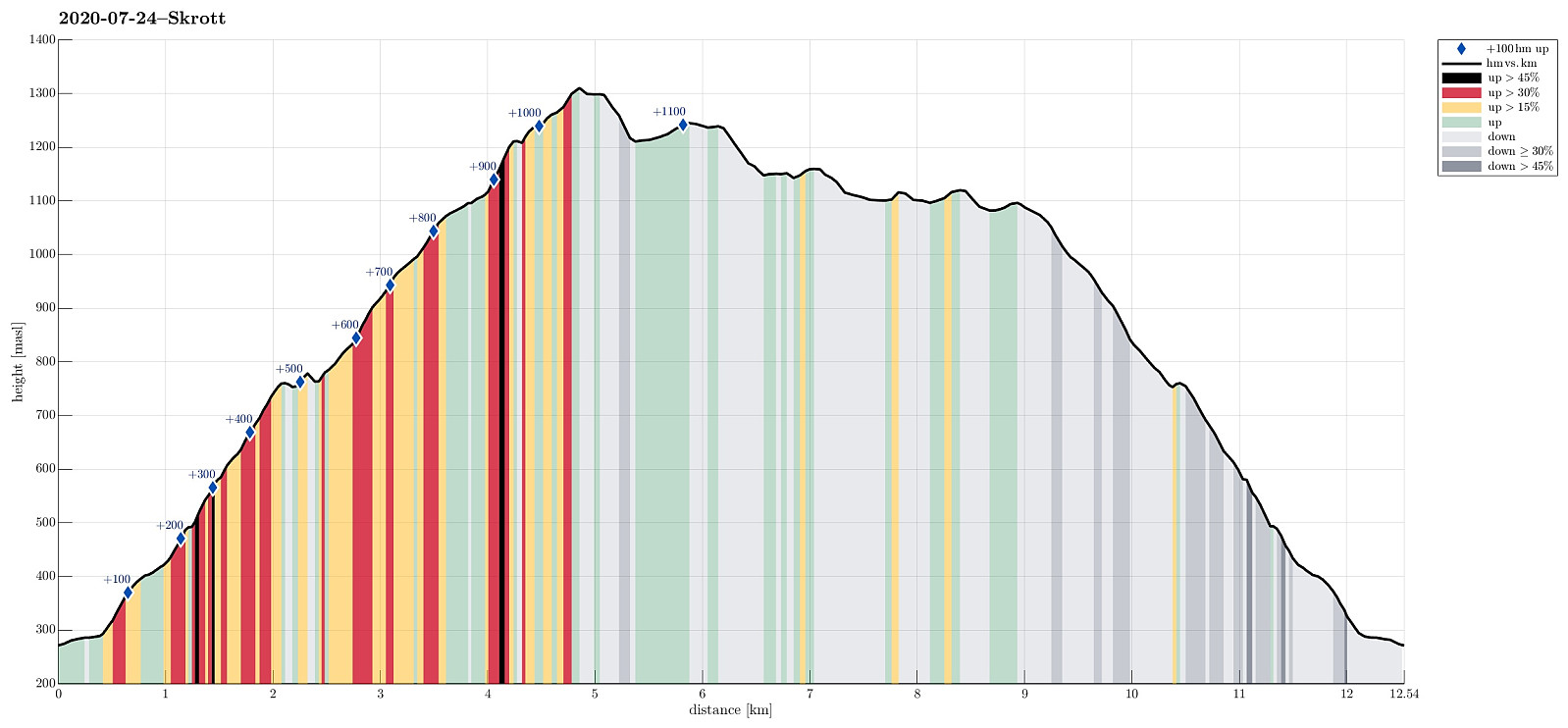 Expecting a nice summer day, we headed into the direction of Hardanger. Our plan was to ascend to Skrott, starting from Fitjadalen. After first driving to Øystese, via Kvamskogen, we turned into a northwards direction in Øystese, ascending east of Øysteseelva towards Fitjadalsvatnet. After rounding Fitjadalsvatnet on its eastern side, we parked at Fitjadalen and started hiking along the nicely marked trail leading up to Breidablik via Håsete and Vindskjersleitet. One first walks a bit "kind of" level until crossing Kjølo, coming down from Smørdalen, before then starting a significant ascent into the direction of Håsete. All in all, there isn't too much interesting to write about this trail, rather than that it's straight-forward to follow. At Håsete, we deviated for >>>
Kongsfjellet via Kongskleivo
- Date:
- 23.07.2020
- Characteristic:
- Hillwalk
- Duration:
- 1:30h
- Distance:
- 3.8km
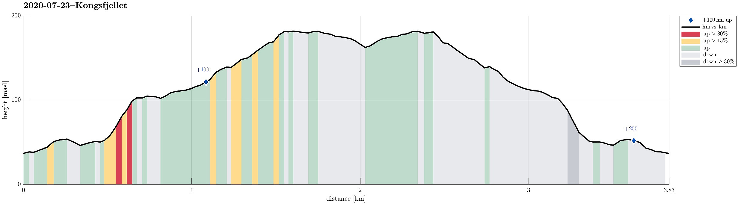 Before returning from Austevoll, we decided to include Kongsfjellet near Bekkjarvik. Passing by Bekkarvik church, we headed toward the starting point of Kongskleivo, i.e., the newly layed stone path up to Kongsfjellet. After first rounding Taushaugen in its east and south, we started with stepping up the big stone steps, ascending to the "top" of Taushaugen before continuing to Kongsfjellet. At Kongsfjellet, we enjoyed some nice views in all directions (mostly across Bekkjarvik and southwards). We then walked a bit across the ridge of Kongsfjellet before hurrying down the stone steps, again, in order to secure a relaxed drive back to the ferry in Hufthammar. All in all, Kongskleivo is, yes, impressive due to the big stones, while then, also, kind of boring. The views from Kongsfjellet, >>>
Vinnesvatnet and Veten
- Date:
- 22.07.2020
- Characteristic:
- Hillwalk
- Duration:
- 2:00h
- Distance:
- 5.5km
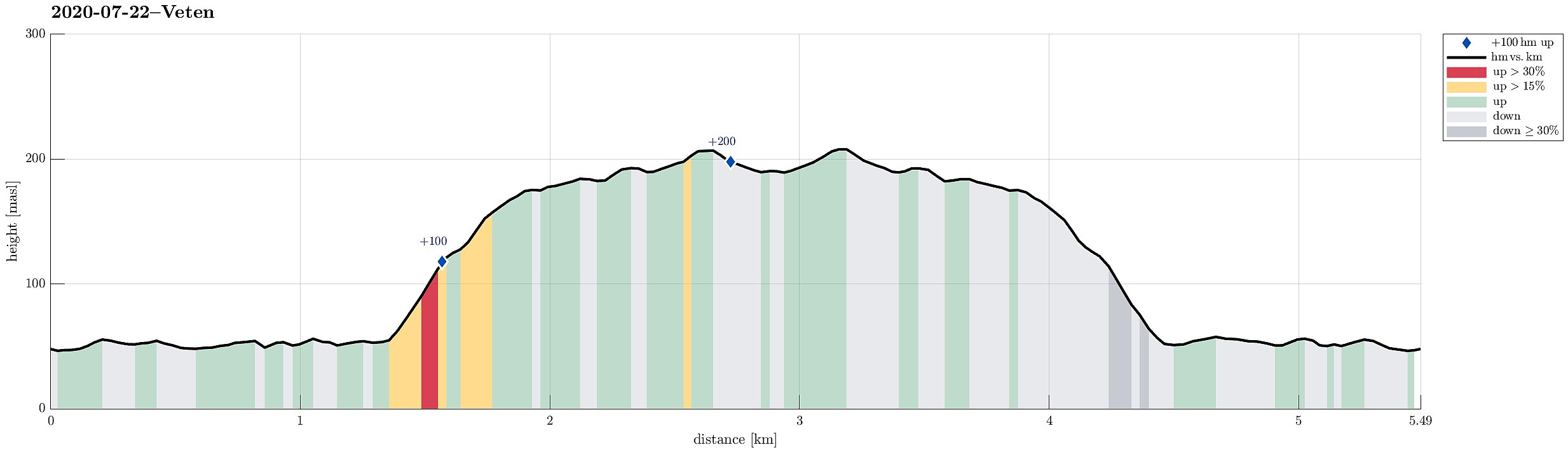 We took the ferry from Krokeide to Hufthammar and continued southwards from there, following the road into the direction of Husavik (road 546). After passing Husavik, we approached Vinnes, making a spontaneous decision to visit Vinnesvatnet from there. We parked near Hoppensprett kindergarten and started walking along a gravel path that leads very nicely around Vinnesvatnet. On the western side of Vinnesvatnet, we also visited the little island in Vinnesvatnet, walking across a nice little hanging bridge. At the northern end of Vinnesvatnet, where the gravel path deviates a bit from the lake, we started following a trail leading to Veten. After first ascending significantly, we then had a pleasant walk over the heights in the southeast of Veten. Eventually, we came to Veten, enjoying >>>
To Bergen and back
- Date:
- 18.07.2020
- Characteristic:
- Hillwalk
- Duration:
- 6:00h
- Distance:
- 19.8km
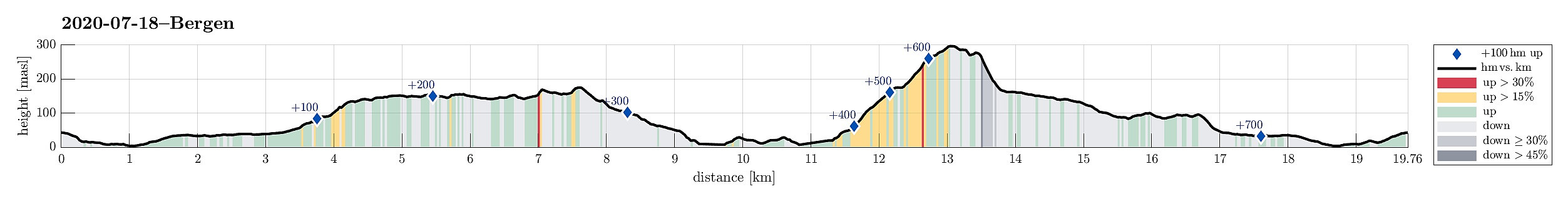 Walking up Fyllingsdalen and further to Bergen. Enjoying a beer, or two. Walking back. Not much more to write, this time. :-)
See also the related FB-page Hiking around Bergen, Norway .
Walking up Fyllingsdalen and further to Bergen. Enjoying a beer, or two. Walking back. Not much more to write, this time. :-)
See also the related FB-page Hiking around Bergen, Norway .
Visiting Kavlane from Kallestad
- Date:
- 11.07.2020
- Characteristic:
- Hike
- Duration:
- 5:00h
- Distance:
- 12.2km
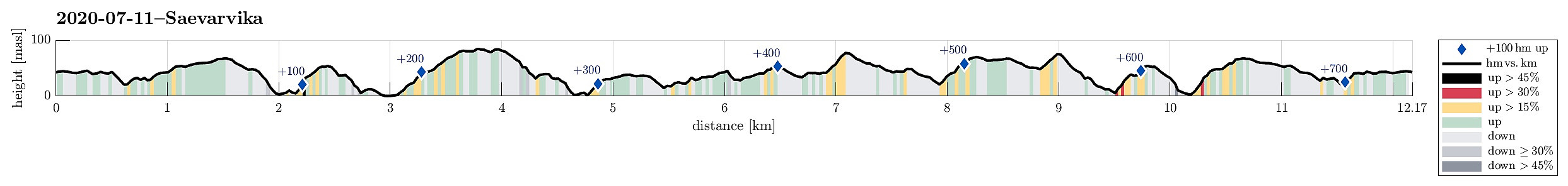 Hoping for a bit of OK weather, we aimed at the islands in the west of Bergen. Road 555 brought us to Sotra, where we turned south. Passing by Fjell and continuing along road 555 into the direction of Hammarsland, we turned right after Dalseidet, taking road 203 towards Kallestad. There, we parked right next to Grendahuset, starting our hike from there, passing by a few of the houses of Kallestad before getting "out into the wild", west of Kallestad. While the first meters past the last house are still on a kind of gravel road, this quickly changes into a nicely marked trail (Nordsjøløypen), which passes by Stølstjørna (in its southwest), then turning westwards, again, leading through a minor valley to Kjereidet. There, Kørelen (in the south) empties into Kjereidosen (in >>>
Skåldalsfjellet from Bjørndalen
- Date:
- 04.07.2020
- Characteristic:
- Hike
- Duration:
- 3:30h
- Distance:
- 8.1km
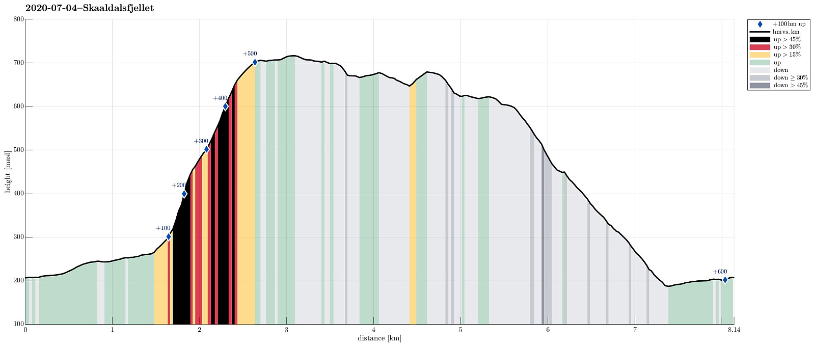 We drove past Grimevatnet and Haukelandsvatnet into the direction of Osavatnet near Gullfjellet, but stopped next to Gullfjellsvegen where the road crosses a small saddle between Ramsdalshovden in the east and Vemånen in the west to continue along Skåldalselva from there. Leaving our car behind, we continued along this road walking, first around Ramsdalshovden on the right (south) and then around Hjelterinden on the left (north). At Søre Bjørndalen, we used a bridge which leads over Skåldalselva to a few houses on the north-side of the valley. Once on this other side, there, we continued first further along a simple road (passing by Nordre Bjørndalen), before starting our actual ascent to Skåldalsfjellet via Høgrusten. On Norgeskart, we had seen that -- while not on a trail -- it >>>
