Archive - Date
Archive - Activity
-
Bike trip (137)
- Bike trip - mixed (51)
- Bike trip - road (9)
-
Other trip (1)
- Kayaking (1)
-
Other winter trip (4)
- Snowshoe trip (4)
- Ski trip (4)
- Trip by foot (740)
Archive - Geography
Peakbook-Friends


Collected lists
-
Bergen ≥ 50m pf. og ≥ 100 m.o.h.
(87/89)
 97%
97% -
Most dominating tops of the Bergen peninsula
(68/75)
90%
-
Utvalgte topper og turmål i Bergen
(316/350)
90%
-
Alle topper i Bergen
(357/398)
89%
-
Opptur Bergen
(100/113)
88%
-
De syv fjell rundt Bergen
(6/7)
85%
-
Sund ≥ 50m pf.
(14/18)
77%
-
Os ≥ 50m pf.
(25/34)
73%
-
Søyler (fastmerker) i Bergen
(68/100)
68%
-
Fjell ≥ 50m pf.
(21/32)
65%

Sandviksfjellet, Rundemanen, Blåmanen, and Midtfjellet
- Date:
- 26.02.2017
- Characteristic:
- Hillwalk
- Duration:
- 3:45h
- Distance:
- 12.1km
 We took bus #4 and got off at stop Sandvikstorget. We found a way up to Amalie Skrams vei and continued along Uren to get further up. Eventually, we went Sudmanns vei up to its end. There, one can sneak through some openings in order to get further up (to Fjellveien). Once on Fjellveien (there), it is only a few meters, before one can start with Stolzekleiven.
We then ascended along Stolzekleiven in order to reach Sandviksfjellet. Clearly, many others were also out in order to test their strengths on Stolzekleiven. It is quite impressive, one must admit, with its many steps and the steep ascent to the top end, roughly 300 height meters above Fjellveien. One their, we continued off-trail along the (gentle) ridge in order to get to the actual "top" of Sandviksfjellet (a place, >>>
We took bus #4 and got off at stop Sandvikstorget. We found a way up to Amalie Skrams vei and continued along Uren to get further up. Eventually, we went Sudmanns vei up to its end. There, one can sneak through some openings in order to get further up (to Fjellveien). Once on Fjellveien (there), it is only a few meters, before one can start with Stolzekleiven.
We then ascended along Stolzekleiven in order to reach Sandviksfjellet. Clearly, many others were also out in order to test their strengths on Stolzekleiven. It is quite impressive, one must admit, with its many steps and the steep ascent to the top end, roughly 300 height meters above Fjellveien. One their, we continued off-trail along the (gentle) ridge in order to get to the actual "top" of Sandviksfjellet (a place, >>>
Hæddena and Hoklane
- Date:
- 12.02.2017
- Characteristic:
- Hillwalk
- Duration:
- 2:45h
- Distance:
- 6.4km
 We drove to Arna from Bergen and continued (for a bit) on E16 until we came to the large bridge, which connects Osterøy for drivers. We crossed the bridge and took the first turn to the right (into the direction of Bruvik), instead of entering the long tunnel that leads further inlands and north on Osterøy. We drove this narrow and winding road a little bit to the east until we came to a small place called Blom. There we parked our car along the "main road" (at the eastern end of Blom), after we had asked and checked that this was OK.
From the car we first walked a few meters back (in northwestern direction), following a narrow secondary road that connects to the few buildings of Blom. Only a few meters up this small road, one can easily find the trail head for this hike (there >>>
We drove to Arna from Bergen and continued (for a bit) on E16 until we came to the large bridge, which connects Osterøy for drivers. We crossed the bridge and took the first turn to the right (into the direction of Bruvik), instead of entering the long tunnel that leads further inlands and north on Osterøy. We drove this narrow and winding road a little bit to the east until we came to a small place called Blom. There we parked our car along the "main road" (at the eastern end of Blom), after we had asked and checked that this was OK.
From the car we first walked a few meters back (in northwestern direction), following a narrow secondary road that connects to the few buildings of Blom. Only a few meters up this small road, one can easily find the trail head for this hike (there >>>
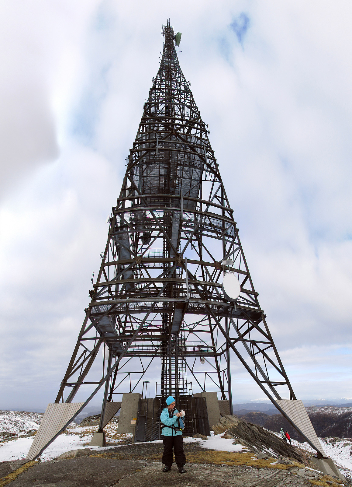
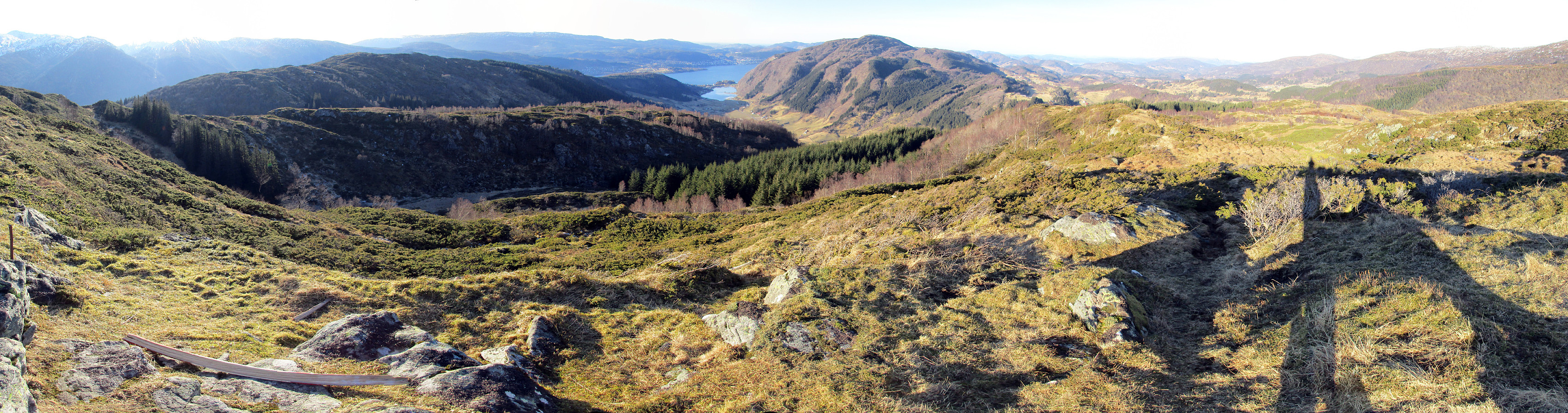
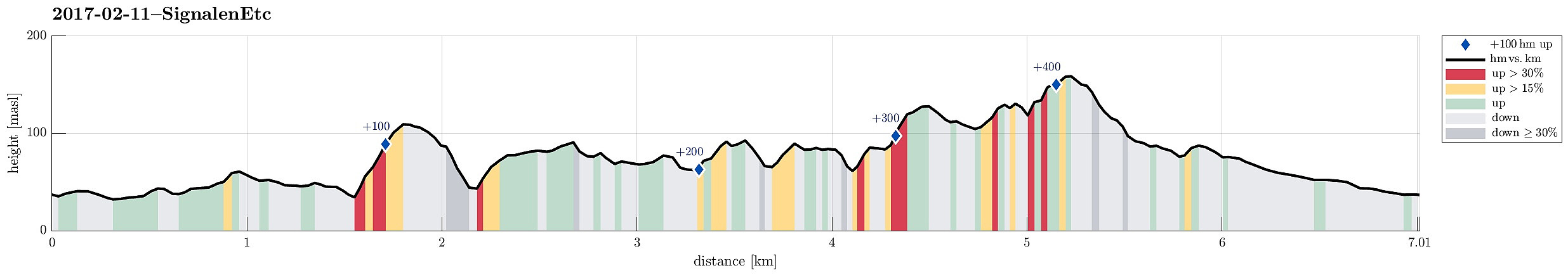
Gardafjellet and Signalen
- Date:
- 11.02.2017
- Characteristic:
- Hillwalk
- Duration:
- 3:00h
- Distance:
- 7.0km
 We took road #555 towards the west of Bergen, crossing Sotrabroen and the tunnel near Kolltveit. Turning left, right afterwards, we continued on road #555 towards Fjell, where we turned right, taking road #559 further westwards. At Ulveset, very near to the school there, we parked and started to hike.
We first followed a small road called Trippevegen in northeastern direction, up to a relatively sharp turn. There, we found the path, which leads further north (instead of following the road, which extends towards the west). We followed this path to a point, which is marked with "Litlestengelen". From there we continued without a path in northeastern direction, heading towards Gardajellet (a bit north of Kvernavatnet). Hiking was all easy (mostly because the ground was conveniently >>>
We took road #555 towards the west of Bergen, crossing Sotrabroen and the tunnel near Kolltveit. Turning left, right afterwards, we continued on road #555 towards Fjell, where we turned right, taking road #559 further westwards. At Ulveset, very near to the school there, we parked and started to hike.
We first followed a small road called Trippevegen in northeastern direction, up to a relatively sharp turn. There, we found the path, which leads further north (instead of following the road, which extends towards the west). We followed this path to a point, which is marked with "Litlestengelen". From there we continued without a path in northeastern direction, heading towards Gardajellet (a bit north of Kvernavatnet). Hiking was all easy (mostly because the ground was conveniently >>>
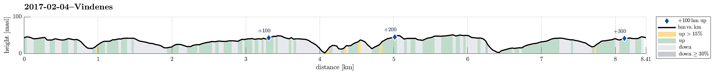
Nice hike on Vindenes
- Date:
- 04.02.2017
- Characteristic:
- Hike
- Duration:
- 3:00h
- Distance:
- 8.4km
 We drove westwards from Bergen, towards Sotra. After passing through the tunnel under Kolltveit, we turned right at the roundabout, continuing on road #561 in northwards direction. We drove through Knappskog to Ågotnes, where we left the main road at a roundabout, which also is the main entry point to the extended business area at Ågotnes, continuing on Bleivassvegen (again northwards) until we reached Vindenes. There we continued (just for very short) a little bit upwards onto the peninsula (to the northeast) until we found a suitable parking place near Vardhaugen (almost where the bus also turns).
From there, we walked, following first a smaller road that leads northwards a bit to the west from the road along with we had parked. After only a few meters, we passed by a parking spot (just >>>
We drove westwards from Bergen, towards Sotra. After passing through the tunnel under Kolltveit, we turned right at the roundabout, continuing on road #561 in northwards direction. We drove through Knappskog to Ågotnes, where we left the main road at a roundabout, which also is the main entry point to the extended business area at Ågotnes, continuing on Bleivassvegen (again northwards) until we reached Vindenes. There we continued (just for very short) a little bit upwards onto the peninsula (to the northeast) until we found a suitable parking place near Vardhaugen (almost where the bus also turns).
From there, we walked, following first a smaller road that leads northwards a bit to the west from the road along with we had parked. After only a few meters, we passed by a parking spot (just >>>
