Archive - Date
Archive - Activity
-
Bike trip (137)
- Bike trip - mixed (51)
- Bike trip - road (9)
-
Other trip (1)
- Kayaking (1)
-
Other winter trip (4)
- Snowshoe trip (4)
- Ski trip (4)
- Trip by foot (740)
Archive - Geography
Peakbook-Friends


Collected lists
-
Bergen ≥ 50m pf. og ≥ 100 m.o.h.
(87/89)
 97%
97% -
Most dominating tops of the Bergen peninsula
(68/75)
90%
-
Utvalgte topper og turmål i Bergen
(316/350)
90%
-
Alle topper i Bergen
(357/398)
89%
-
Opptur Bergen
(100/113)
88%
-
De syv fjell rundt Bergen
(6/7)
85%
-
Sund ≥ 50m pf.
(14/18)
77%
-
Os ≥ 50m pf.
(25/34)
73%
-
Søyler (fastmerker) i Bergen
(68/100)
68%
-
Fjell ≥ 50m pf.
(21/32)
65%

Canal du Midi
- Date:
- 19.07.2015
- Characteristic:
- Bike trip
- Duration:
- 6:00h
- Distance:
- 29.0km
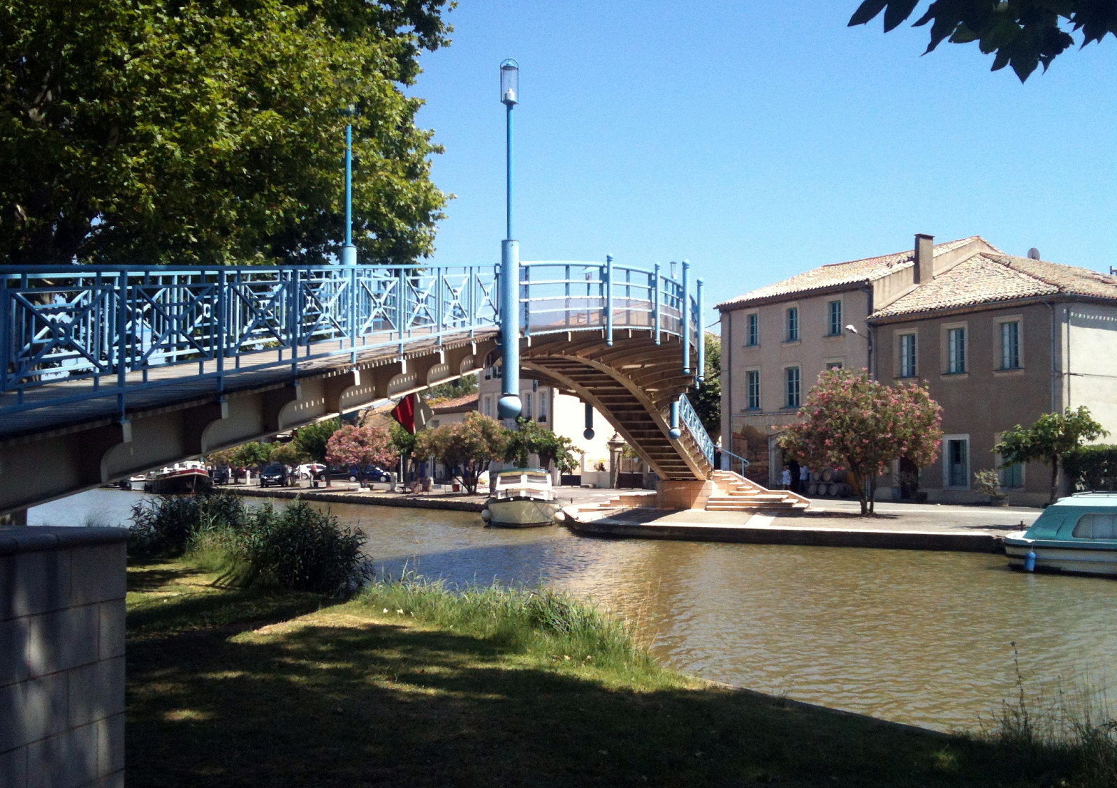 Half a day of cycling along the Canal du Midi (between Narbonne and Carcassonne) and in nearby small villages -- very hot day, but a nice way of exploring traditional France, this way! :-)
Selected photos are available as Google+ photo album .
Half a day of cycling along the Canal du Midi (between Narbonne and Carcassonne) and in nearby small villages -- very hot day, but a nice way of exploring traditional France, this way! :-)
Selected photos are available as Google+ photo album .
North of Ollioules
- Date:
- 13.07.2015
- Characteristic:
- Hillwalk
- Duration:
- 2:00h
- Distance:
- 6.7km
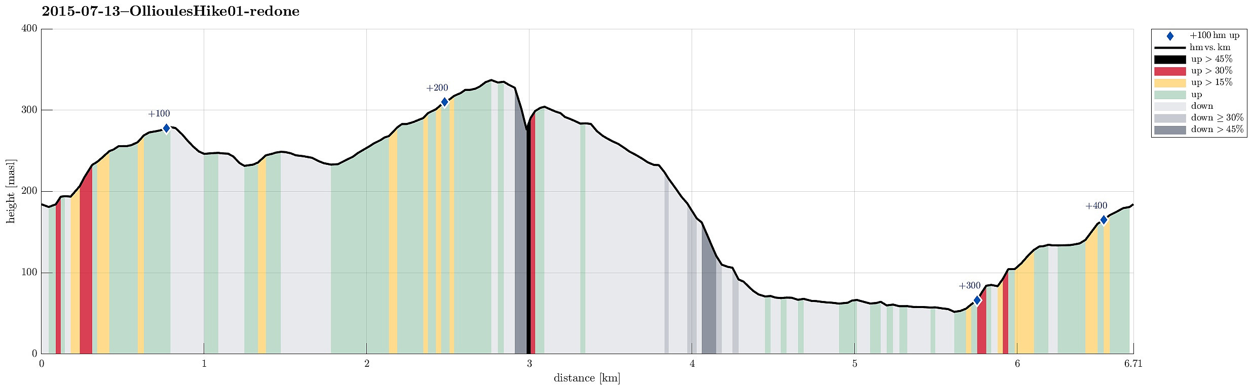 A spontaneous morning hike in the north of Ollioules with nice views over the canyon of Destel.
Selected photos are available as Google+ photo album .
A spontaneous morning hike in the north of Ollioules with nice views over the canyon of Destel.
Selected photos are available as Google+ photo album .
Le Mai
- Date:
- 13.07.2015
- Characteristic:
- Hillwalk
- Duration:
- 2:00h
- Distance:
- 6.1km
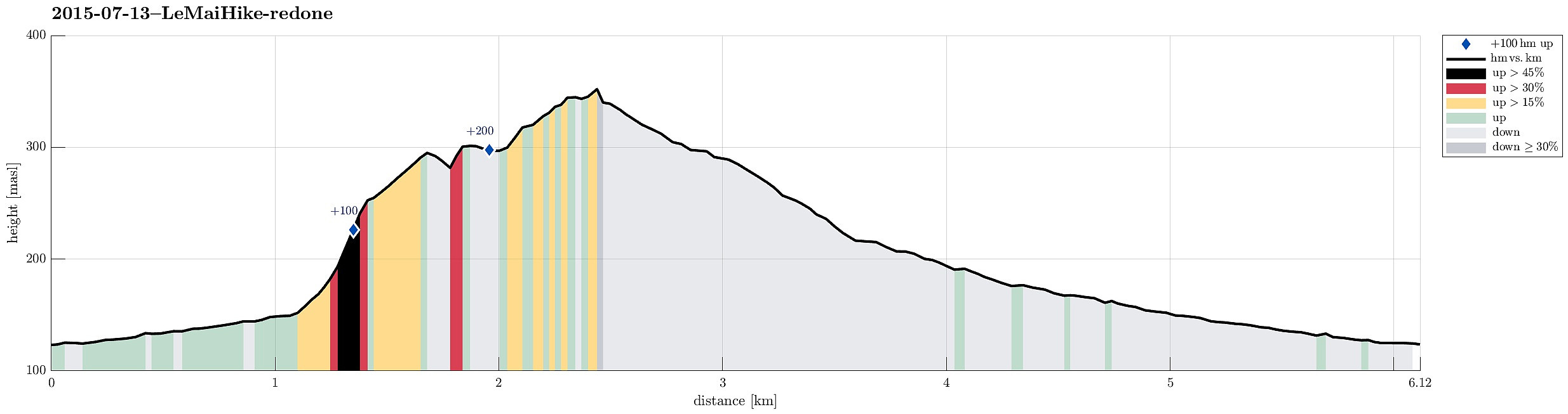 Quick evening hike on Le Mai with outstanding views over both the south (The Mediterranean Sea) and the north (Toulon).
Selected photos are available as Google+ photo album .
Quick evening hike on Le Mai with outstanding views over both the south (The Mediterranean Sea) and the north (Toulon).
Selected photos are available as Google+ photo album .
Schober & Frauenkopf
- Date:
- 09.07.2015
- Characteristic:
- Hillwalk
- Duration:
- 1:45h
- Distance:
- 3.6km
 We parked right next to Forsthaus Wartenfels and ascended to the ruin Wartenfels that towers above the Forsthaus (only a few minutes up). From there, it is a quick ascent up to Schober, from where one enjoyes exceptional views in all directions. The matter of fact that Schober is kind of the northernmost (somehow) higher mountain frees extended views in many directions! From there, we connected to Frauenkopf, which is only a few steps away from Schober. From there, one gets back to Forsthaus Wartenfels via a good-to-walk path, mostly through the forest underneath Schober. In total, this hike is short and rewarding. At a few places, there are steel ropes that help to ascend/descend and at some very few places you have to watch you step, when getting up, down, or around. With a little >>>
Grosser & Kleiner Sonnstein
- Date:
- 06.07.2015
- Characteristic:
- Hillwalk
- Duration:
- 3:00h
- Distance:
- 5.5km
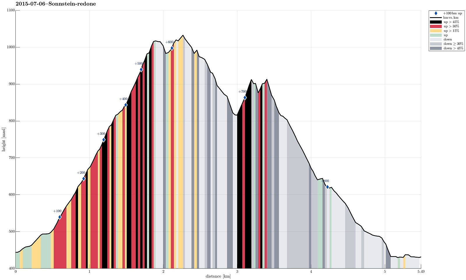 We started with two cars, leaving one a small parking spot south of Traunkirchen (if you drive from north, for ex., Gmunden, in the driection of Bad Ischl, then you first cut short Traunkirchen through a tunnel -- shortly afterwards you pass through a very short new tunnel and then the parking spot is on the right). Then we drove further, with the other car, towards Ebensee. As soon as we entered Ebensee, even before crossing the Traun, we turned right at the first opportunity (onto Hauptstrasse). After only a short distance -- basically at the first regular option to turn right, again -- we turned right (onto Langbarthstrasse). From there, we turn right again, into Kirchengasse -- this turn is not obvious (the turn is very sharp and Kirchengasse is very narrow). Right next to the church >>>
