Vallaheiane via Larsaberget from Tranevatnet (11.05.2025)

| Start point | Varden (45m) |
|---|---|
| Endpoint | Varden (45m) |
| Characteristic | Bike trip - mixed |
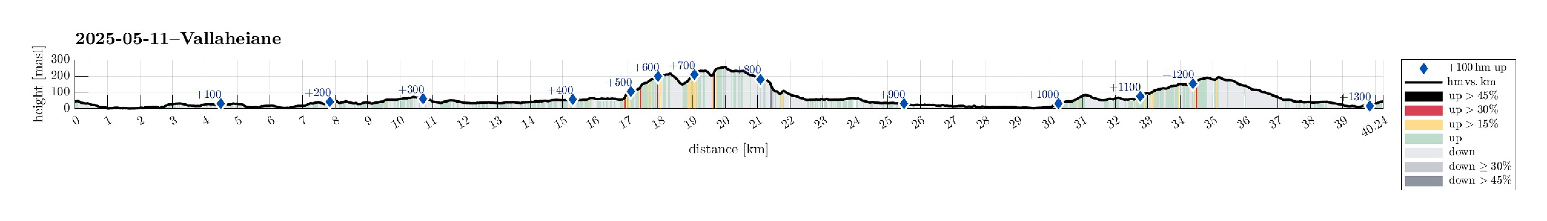
| Duration | 4h 30min |
| Distance | 40.2km |
| Vertical meters | 1,328m |
| GPS |
|
| Ascents | Kråkåsen (239m) | 11.05.2025 |
|---|---|---|
| Torneberget (235m) | 11.05.2025 | |
| Vardane (259m) | 11.05.2025 | |
| Visits of other PBEs | Fyllingsdalstunnelen - Oasensiden (34m) | 11.05.2025 |
| Grønhaugen i Siljustølskogen (51m) | 11.05.2025 | |
| Harald Sæverud Museum Siljustøl (75m) | 11.05.2025 | |
| Siljustøl parkering (64m) | 11.05.2025 | |
| Straume bro (5m) | 11.05.2025 | |
| Sælen kirke p-plass (15m) | 11.05.2025 |
Trip Summary
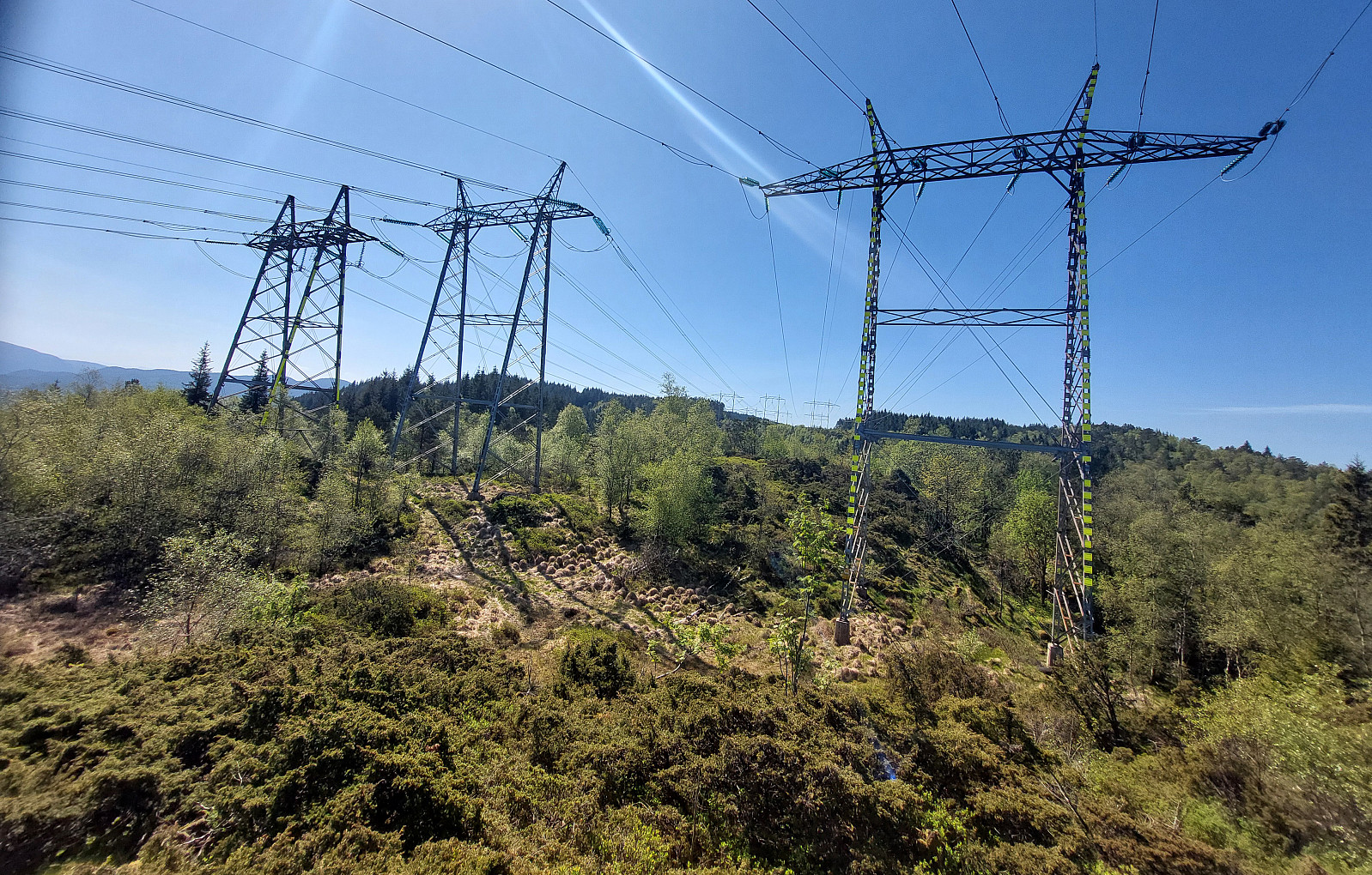
The main idea was to get some fresh air. I thus took the bike and started with the idea to explore Vallaheiane from Tranevatnet. I first biked south and crossed the partially closed off bridge at Straume. I then continued towards Steinsvik, where I left the "main road" to take a look at Ospåsen, a bit further south. The matter of fact that there's also a golf course in this area does not make getting around easier. Back on my bike, I continued, crossing over Flyplassvegen, to the sports arena next to Grimseidvegen. After a short bio-break at Lagunen, I continued around Apeltunvatnet, then to Iglavatnet, and further to Tranevatnet. I then parked my bike along the gravel road on the south side of Tranevatnet to start my exploration on foot from there. I first found a good way to get up to the hills in the southeast of Tranevatnet, also enjoying some nice panoramic views from there. I then continued via Støhaugen, connecting to a major trail that leads up from Litletveiten to Torneberget. A bit above 180masl, I then forked off this main trail, first following a very minor trail (if that's a trail at all) into the direction of Larsaberget. The last meters to and up Larsaberget were then without any trail (and with some minor bushes to "fight"). After exploring Larsaberget (and searching for some nice views, which I did not really find), I then aimed at finding another trail in the southeast of Larsaberget, which should bring me down to Dalen near Osvegen (and then over to Småkråkåsen). Only a bit of more off trail searching was necessary, before I found this trail. On the other side of Dalen, I then aimed at the northern ridge of Småkråkåsen, where I eventually found a nice (minor) trail, which was good to follow upwards (in southern direction). Once up at Vallaheiane, I crossed over the heights, including Kråkåsen, getting a close-up impression of the three major power lines that cross overhead there. Next, I wished to cross over to Vardane in the west of Vallaheiane. Up from the saddle, I did not see the trail, which the map had promised -- maybe because of the cut down trees there. Instead, I just ascended to the heights in the southeast of Vardane without a trail (steep, but no problem at all). Once up to 250masl, I connected with a trail, again, and from there it then was only a few meters to Vardane. From there to Torneberget, I simply followed one of the major trails. The next question was about how to descend back down to Tranevatnet (I had not really spotted any trail on the map). Instead, I followed some "random trails" in the north and then northwest of Torneberget. Eventually, following these trails made me walk around Storlia in the south, bringing me down to Smørås. Walking back to my bike was then only a question of following the right streets. Back on my bike, I round my way to Nesttun and from there along the main cycling route northwards to Fjøsanger. Instead of biking home, directly from there, however, I included a stop at Nils Langhelles vei. To get there, I first biked up Bønes and then pushed the bike up from Bråtet to the southern end of Nils Langhelles vei. It should be mentioned that the southern most end of this connection is significantly steep and clearly very uneven -- altogether not really a stretch which is recommended with the bike!
Photos
Selected photos are available as Google photo album.
Useful Resources
See also the related FB-page Hiking around Bergen, Norway.

Kommentarer