From Odda to Buardalen via Ruklenuten (03.08.2024)

| Start point | Eidesåsen (245m) |
|---|---|
| Endpoint | Buer (300m) |
| Characteristic | Hike |
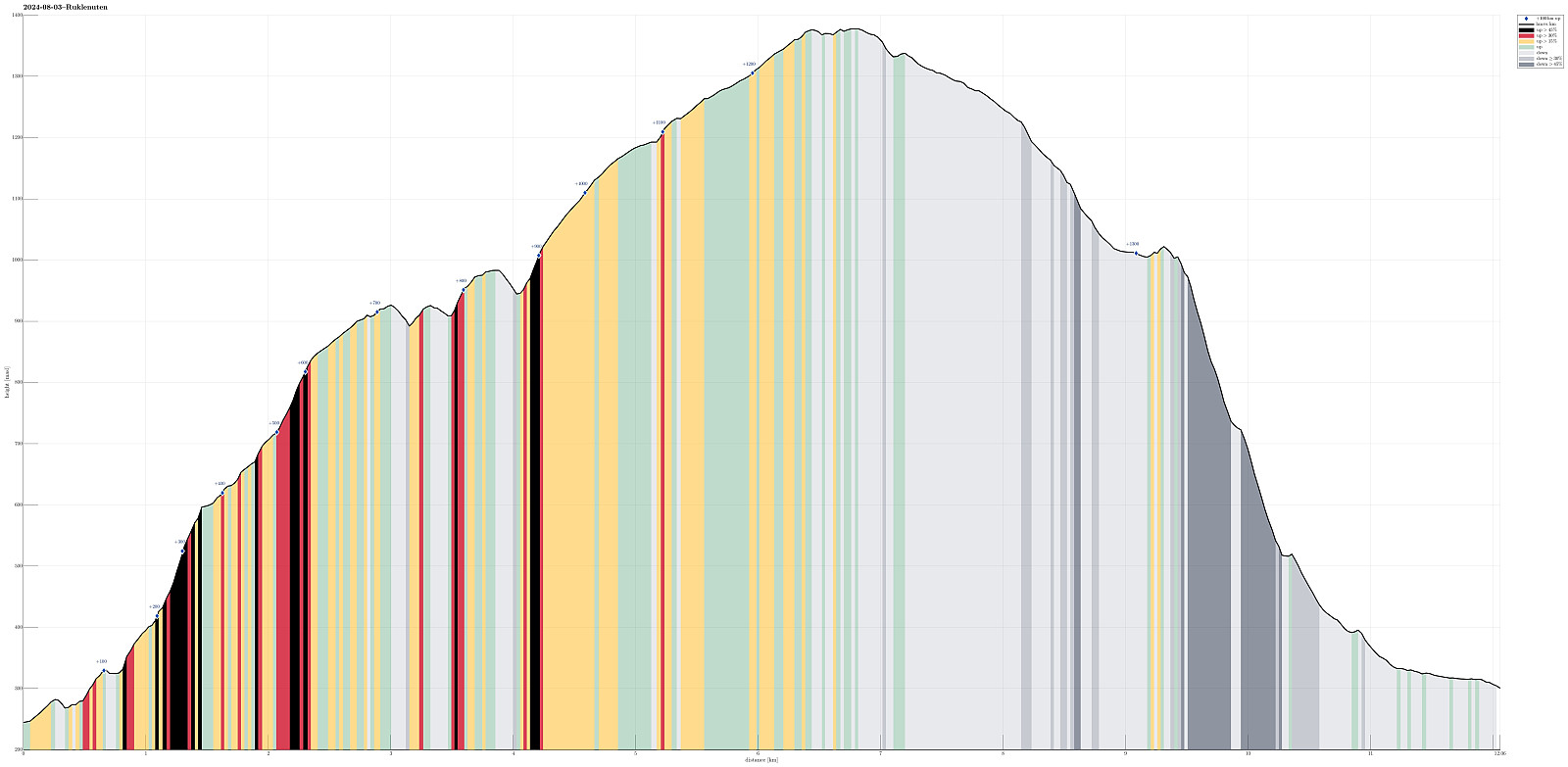
| Duration | 8h 00min |
| Distance | 12.1km |
| Vertical meters | 1,352m |
| GPS |
|
| Ascents | Eidesnuten (930m) | 03.08.2024 |
|---|---|---|
| Ruklenuten (1,380m) | 03.08.2024 | |
| Visits of other PBEs | Buardalen parkering (300m) | 03.08.2024 |
While the hike up to Eidesnuten is well-marked and following a good trail, the descent from Langgrødbotnen down into Buardalen is VERY steep! The trail that is supposed to lead down this valley was almost impossible to find, and the descent required a lot of care (and time).
Trip Summary
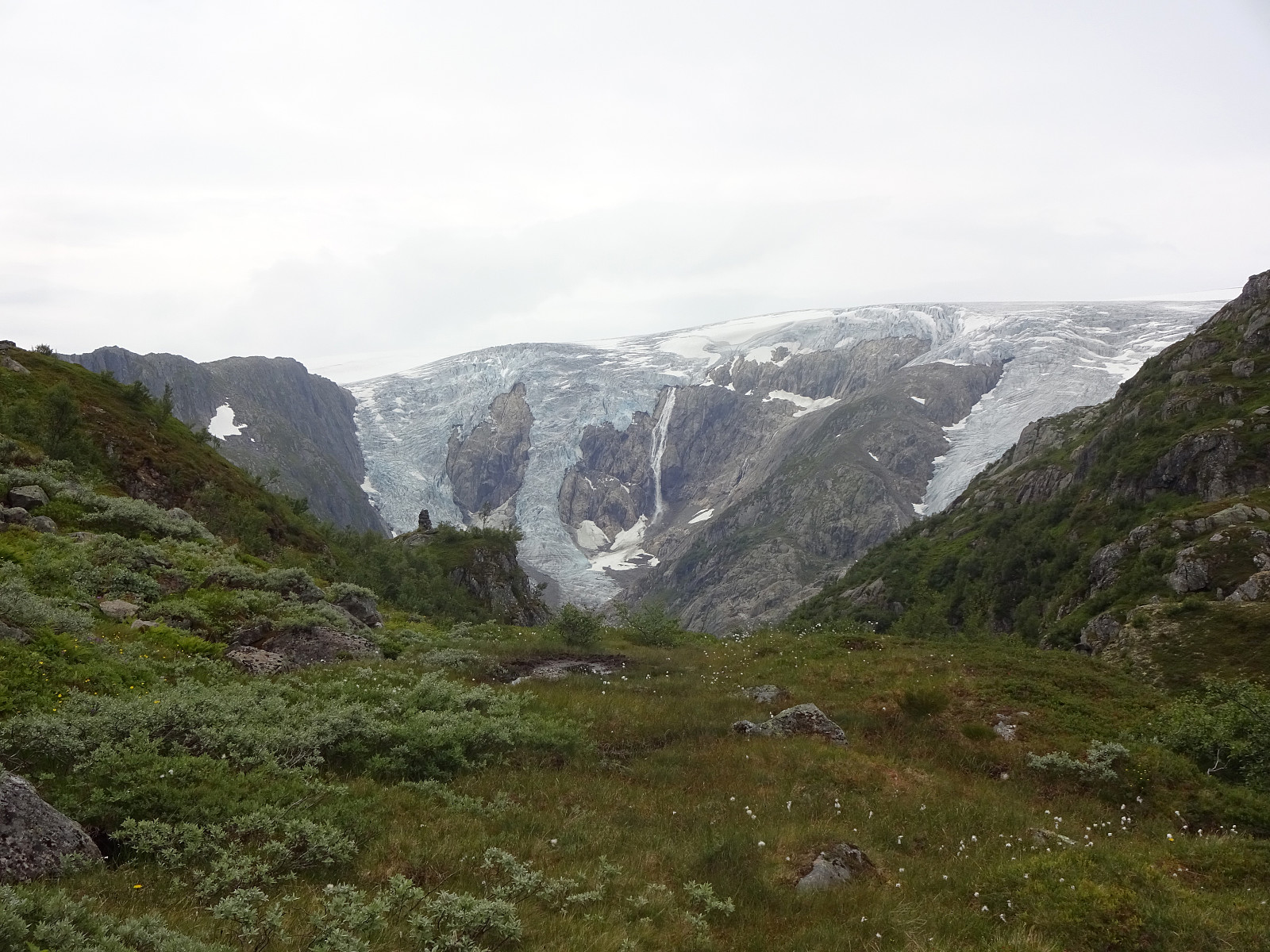
We wished to make a nice hike from Odda and found Eidesnuten as a worthwhile hiking target, promising nice views in multiple directions. Starting from Eidesåsen, some 250masl and about 150 heights meters above Eide in the south of Odda, we followed a very well-marked trail. Even though one may expect more hikers on such a well-treated trail, we did not meet anyone. Within not too long, we arrived at Eidesnuten and found that our expectations regarding the views were indeed well-founded. Not only could we see northwards and out Hardangerfjorden, north of Odda, as well as southwards, across the large lake Sandvinvatnet, but also we got some nice views over to Buarbreen, already from Eidesnuten. From Eidesnuten, our goal had been to ascend further upwards to Ruklenuten (in the northwest of Eidesnuten). Before really doing so, however, we wished to pay Tjørno a short visit, which is quite close to Eidesnuten (in its northwest). Stepping up there was "straight-forward" (but without a trail, though, as the entire hike across Ruklenuten, then). After a nice short break at Tjørno, we engaged with the first (small) challenge, i.e., to ascent to some higher ground in the west of Tjørno. Even though it was necessary to use our hands in addition to assist a few steep steps upwards, getting up there was not really problematic, after all. Once up to about 1025 masl, or so, making further progress was getting easier, again, and the entire remaining ascent to Ruklenuten was a pleasant walk over the rather gentle heights of Ruklenuten. Once reaching the top (one top) of Ruklenuten, we (a) saw a very nice cairn a bit further north (rather not the highest point on Ruklenuten, neither!) and (b) some additional heights a bit further west, which -- apparently -- included the actually highest point of Ruklenuten. After walking first over to the nice cairn, we then crossed the heights towards the west, where we started our descent towards Langgrødbotnen from the hightest point on Ruklenuten. To proceed towards Langgrødbotnen, we first descended from Ruklenuten into southwestern direction (the western flank of Ruklenuten is a bit steeper than necessary for a relaxed descent). From there, it was then mostly to head into the right direction (hiking was/is easy up there). The next interesting question was to find out where it was best-possible (or reasonable, at least) to actually descent into Langgrødbotnen from the heights of Ruklenuten. Since we had seen on the map that a couple of cliffs mark the eastern side of Langgrødbotnen, we aimed the one valley that seemed to offer the least-steep descent into Langgrødbotnen. Finding this valley, we then found that it actually offered the hoped-for route down into Langgrødbotnen. While this descent was partly steep, it still was without actual problems, mostly over some nice (steep) meadows towards lower ground. Once down to about 1030masl, or so, the route flattened out, again, leading towards Langgrød in southwestern direction. From our map-study we knew that we should not descend all the way down towards the stream through Langgrød, but maintain some height in order to take a "parallel valley" (in the east of the stream) down. The "entry point" is marked with "Såta" on the map and it is also marked "in real" with a large cairn that is situated on a fantastic vista-point. Our ahead-of-hiking attempt to better understand the situation in Langgrød had revealed (a) not much, actually! and (b) that some (weakly marked) trail may be found there. While it seemed, from above, that actually others had used this "trail" (if so, then this must have been weeks ago, at least), it quickly became clear that following this "trail" became VERY difficult (partly impossible), since it was (1) hardly visible to begin with and (2) fully overgrown with lush, hip-high vegetation. Since the descent through Langgrød anyway is VERY steep -- think twice, before choosing to use this valley, especially in a wet condition! -- it really took all the concentration that we could scramble together (and a lot of strength in our legs) to step down this valley. Since every step had to be done with great care, it also too us a long time to make progress. While it is probably right to assume that we indeed followed the "trail" for most of the time, we also lost it repeatedly, which added some extra-challenge to the descent. Given all the very steep terrain there, including lots of cliffs, you really do not want to end up in a "dead-end route" there. Once down to about 520masl, i.e., after having made it down the major part of Langgrød, we ended up quite near to the stream and it remained unclear where the "trail" would continue. We explored the area (up and down, left and right) for a while, but could not find any trace of the "trail" (maybe it's "just" down right next to the stream, there?). This made us diverge into the forest (in the east of the stream). Quickly, this continuation of our descent became quite adventurous: over fallen trees, along minor streams, etc. While it wasn't much, altogether, this final stretch took quite a bit of additional motivation! :-) Anyway: some time later, we made it down to the main trail, which brings the tourist from the parking area in Buardalen closer to the glacier. While having made the vast majorit of our hike by then, this was the time, when we started to meet people -- then, however, MANY of them! :-) Walking out to the street in Buardalen, however, was then easy and straight-forward. Once past the main parking area, we were able to hitch a ride down the valley (Buardalen) with a pair of the tourists. It clearly was nice and relaxing to not have to walk out the whole valley, especially after our Langgrød-experience! :-)
Photos
Selected photos are available as Google photo album.
Useful Resources
See also the related FB-page Hiking around Bergen, Norway.

User comments