From Stovegolvet to Sagvåg on Stord (11.05.2024)

| Start point | Stovegolvet (695m) |
|---|---|
| Endpoint | Sagvåg (20m) |
| Characteristic | Hike |
| Duration | 5h 00min |
| Distance | 13.2km |
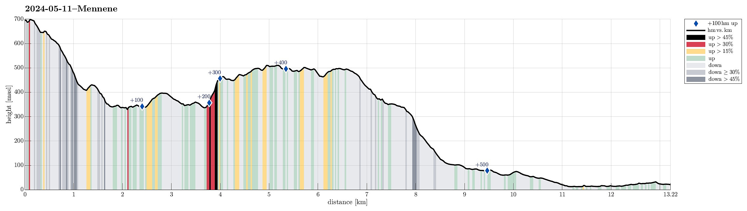
| Vertical meters | 565m |
| GPS |
|
| Ascents | Klovfjellet (515m) | 11.05.2024 |
|---|---|---|
| Mennene (501m) | 11.05.2024 | |
| Stovegolvet (702m) | 11.05.2024 | |
| Visits of other PBEs | Stordalselvo gangbro (60m) | 11.05.2024 |
| Stovegolvet Turisthytte (695m) | 11.05.2024 |
Trip Summary
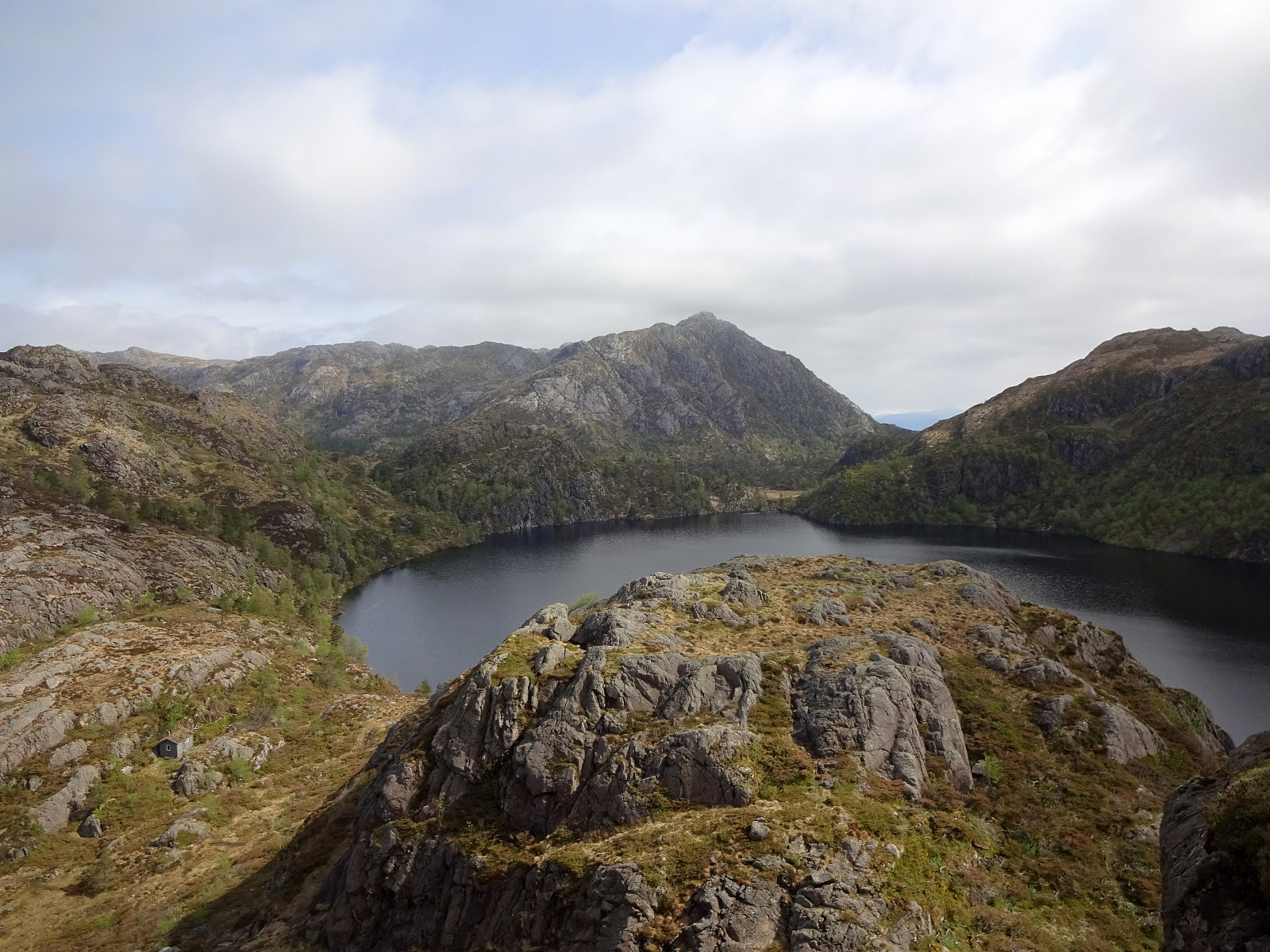
As part 2 of a two-days hike across Stord, we started from Stovegolvet, where we had stayed over night. We first descended (steeply) towards Tysevatnet, following a nice trail down from Stovegolvet. Instead of walking around Eldhushøgda, as prepared for by the trails, we crossed over this little hill, enjoying some nice views from above. Even though a bit steep on its southwestern side, descending back down to the trail was still no issue. We then followed the trail, which leads (also across the one or other dam) along Tysevatnet in its south, to get to the other side and, eventually, further southwards to Ravatnet, crossing over a little saddle in the west of Ramnaskolten. After walking between Ravasslia (in the northwest) and Ravatnet (in the southeast), we arrived at another small saddle (between Ravatnet in the east and Hovtrongsvatnet in the west), north of Kløv. There, we had seen on the map that a side-trail would lead up to Kløv from the north. While the map does not really show the trail-head for this side-trail in correct detail, we still found the trail (and old access road to Støv, actually) and made it up to Kløv without any issues (it's quite impressive, actually, how this access road was built into significantly steep terrain!). Once above the saddle at Kløv, we had hoped to find a way to further ascend (steeply!) towards the southwest (and eventually to Klovfjellet). This mountain side in the southwest of Kløv is indeed very steep and one needs to use hands in addition the feet to actually make it up there (not for everyone, maybe!). Once up to about 425 masl, however, the terrain becomes more managable, again, and proceeding towards Klovfjellet gets more straight-forward (not straight, though, and still without any trail). Once on Klovfjellet, the plan was to continued further "across the heights" to Mennene further in the south. While the map did not show any trail, there, we still found a trail, marked with some small cairns, and following this trail was nice and enabled us to proceed swiftly towards Mennene. From there, we then followed a nice trail down from Mennene. At about 400 masl, this trail enters an impressive valley, which leads down (in southwestern direction) into the direction of Stuvasetertjørna. Before actually getting to this lake, however, another trail forks off towards Bjørnastegen in the southeast. Taking this very nice trail, we quickly descended (partially steeply, yes) further down, eventually arriving in Storedalen and a forrest road through this valley. Following this forrest road through Storedalen, we came to a nice place in the northeast of Lappetjørna (this little lake, however, appeared to have dried out by the time we passed by). Using an old road that apparently was previously used for mining activity in the northeast of Rødkleiv, we arrived in Litlabø soon after. There, however, we understood that our optimism regarding available bus options was without good reason and catching a bus out of Litlabø appeared to be a long-term project (possibly taking days! :-)). We thus decided to walk out to Sagvåg, instead, and catch a bus there. We also tried to hitchhike for these last kilometers along the road, but nobody decided to stop for us. Once in Sagvåg, we still had some time left to enjoy icecream and icetea -- the day had be beautiful (and warm!). :-) From Sagvåg, we then took a bus back north to Sandvikvåg. While the bus schedule suggested that the bus would arrive in time for the passengers to catch a ferry soon after, we had to then understand that bus and ferry are not coordinated. While we still saw cars driving onto the ferry, we were dropped off the bus a few meters too many from the ferry quay. Even hurrying from the bus stop to the ferry did not help: only five to ten meters before getting to the ferry, it decided to sail away, leaving all of us behind. Given the nice weather and the relatively frequent ferries along E39, however, we did not have to wait all-too-long, before then taking the next ferry to Haljem. Interestingly, we then also found out that also in Haljem bus and ferry are not coordinated. Even though bus #600 is on a relatively frequent schedule, also, it would not come by the ferry quay to pick up just arrived passengers, neither. While we were not in any particular hurry, one really wonders how difficult it would be to improve the connection along E39 for travelers without cars...
Photos
Selected photos are available as Google photo album.
Useful Resources
See also the related FB-page Hiking around Bergen, Norway.

User comments