Skåldalsnipa from Moldalia (22.08.2021)

| Start point | Moldalia (100m) |
|---|---|
| Endpoint | Moldalia (100m) |
| Characteristic | Hike |
| Duration | 3h 00min |
| Distance | 8.8km |
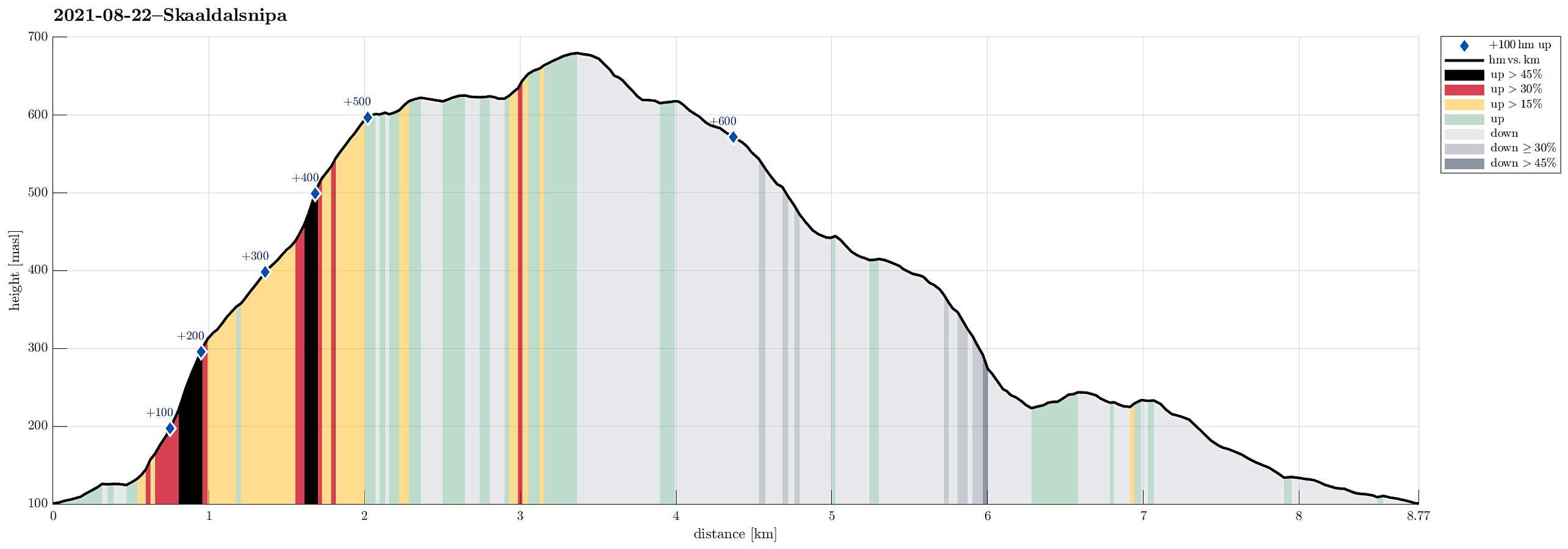
| Vertical meters | 653m |
| GPS |
|
| Ascents | Skåldalsnipa (603m) | 22.08.2021 |
|---|---|---|
| Sælinga (682m) | 22.08.2021 |
Trip Summary
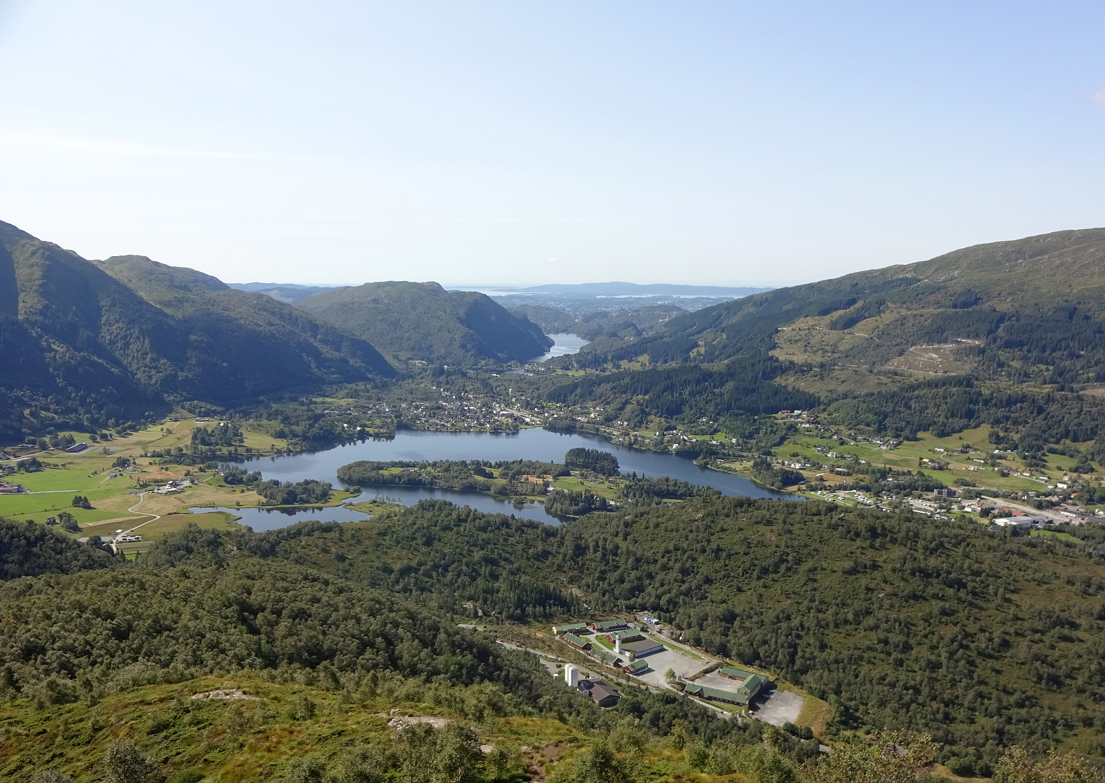
With a lovely late summer day ahead of us, we aimed at exploring a route leading up to / down from Skåldalsnipa that we had not yet hiked, i.e., the "diagonal" that runs (more or less) exactly north-south, connecting Hestabotn (below 450mosl in the north) and Skåldalsnipa (at about 600mosl in the south). To do so, we parked right next to Skåldalselva, where road Moldalia forks off from road Moldamyrane, and started our hike with an ascent towards the ridge that extends southwards from Skåldalsnipa. Starting along a forest road that extends towards the southeast from Moldalia (first kind of parallel to the long pipe installation on the steep western mountain slope of Skåldalsnipa), we located the trail head (after a short, wrong detour) at about 135mosl. From there, a good and straight-forward to find trail is leading upwards (at large in southeastern direction) until it connects to the main trail on the southern ridge of Skåldalsnipa at about 325mosl. From there, it is then "just" up the ridge (at about 450mosl, where the trail switches over to another ridge a bit further in the east, we simply followed the more direct route "straight up", reconnecting with the main trail at about 525mosl shortly later). Once on Skåldalsnipa, we had a very pleasant surprise meeting first (see also the related Peakbook page!), before then continuing our hike. :-) Since it was such a nice day, we included a little extra loop over Sælinga before starting our descent along this "diagonal" towards Hestabotn that we had aimed for. Once done with our "bonus time" "on top", we then got back to Skåldalsnipa (and our primary goal of the day). The trail down to Hestabotn is actually easy to find and follow, leading "diagonally" down the otherwise quite steep western mountain side of Skåldalsnipa. At about 425mosl, the trail switches over to another ridge, delimiting Nedste Hestabotn in its east. All in all, this trail is rich with nice views over the valley quite a bit further down, ranging from Haukelandsvatnet in the south to Arna in the north. At about 350mosl, just west of Stemmebrunane, the trail forks with the northern continuation heading further down towards Meåsen and the southwestern one leading (steeply!) down into the direction of Raudtjørna. Taking the latter option, we descended to about 225mosl just north of Raudtjørna. From there, we first thought that we could follow a trail over the ridge in the west of Raudtjørna, but after first getting there (and up to the "high point" on that ridge) we had to understand that only a fierce bush war could have brought us further down along this ridge in southern direction. Not in the mood for such a bush war, we went back the anyway not very long stretch and continued instead along the gravel road in the west of Raudtjørna. Once passed Raudtjørna (and a few height meters further down in southwestern direction), we left the gravel road and continued instead on a trail through the forest that extends a bit further east than the road, crossing also the little stream not much further down (at about 175mosl). Following this trail "all the way down", we connected back to Moldalia (via Moldamyrane). All in all, returned highly satisfied with this nice hike, understanding that this round up to and down from Skåldalsnipa really is a very nice hiking opportunity in the east of Bergen! :-)
Photos
Selected photos are available as Google photo album.
Useful Resources
See also the related FB-page Hiking around Bergen, Norway.
Petter Bjørstad has a useful page about Skåldalsfjellet and also web page WestCoastPeaks.com provides useful information about Skåldalsfjellet, Herlandsfjellet, Repparåsen, and Arnanipa.
Web page UT.no from the Norwegian Trekking Association recommends a similar hike.

User comments