Tveitafjellet from Fotlandsvåg (18.04.2021)

| Start point | Fotlandsvåg (10m) |
|---|---|
| Endpoint | Fotlandsvåg (10m) |
| Characteristic | Hike |
| Duration | 3h 00min |
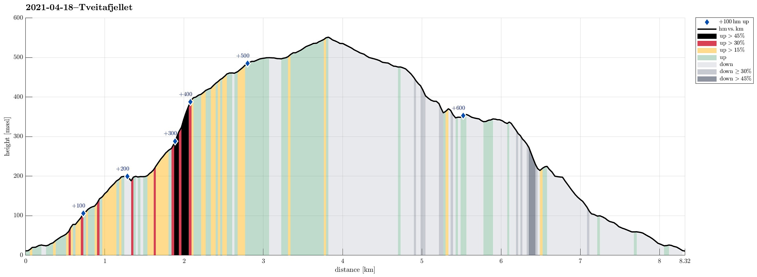
| Distance | 8.3km |
| Vertical meters | 644m |
| GPS |
|
| Ascents | Tveitafjellet (555m) | 18.04.2021 |
|---|
Trip Summary
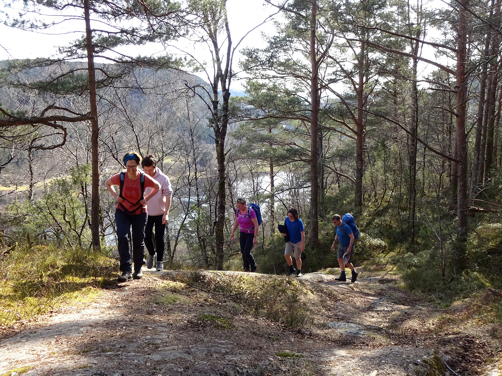
We started in Fotlandsvåg on the north of Osterøy, right next to Fjordslottet (between Herlandsvatnet in the south and Fotlandsvågen in the north), first walking up to the fotball field (in the west of Fotlandsvåg), and from there, diagonally upwards, along a forest road in southern direction. At a bit more than 50mosl, we then stepped onto a marked trail that leads up to Fotlandssætra (about 200mosl) and from there further up to Vetaskaret. While nobody could have asked for a nicer day, with spring temperatures and lots of sun, we soon found the somewhat steep ascent towards Vetaskaret covered in (relatively hard) snow. With a bit of care, however, and/or the right shoes, we nonetheless made our way up without major difficulties. At Vetaskaret, we briefly contemplated a short detour to Åsheimveten, but dropped it then and continued directly towards Tveitafjellet, following the extended (non-steep) ridge from Vetaskaret in southern direction. At the top of Tveitafjellet, we then enjoyed the amazing day for a short while. Since there was quite consistent agreement that walking down from Vetaskaret over the steep, hard snow was not exactly inviting, we instead did the following: While all but two chose to descend towards Åsheim and Hosanger, the remaining two started their return to Fotlandsvåg (in order to get the cars from there for picking up the others in Hosanger). For some reason, there was also an idea of a small adventure in the air, and so it was decided that an alternative route back to Fotlandsvåg should be tried. When looking up from Fotlandsvåg in the morning, we had the impression that connecting Storfjellet (in the east of Tveitafjellet) and Tveitafjellet appeared possible. This, paired with the assumption that connecting Storfjellet and Fotlandsvåg should be possible, as well, made us give this alternative a try. We first walked the northern ridge of Tveitafjellet (that we had come up before) back until we came close to the little lake that's right next to this ridge (at about 490mosl). Before actually getting there, however, we then turned right/eastwards (into the direction of Storfjellet), passing by the lake on its southern side. On the higher grounds there, we still followed a marked trail that appeared to lead us into the right direction. Once down to a bit above 450mosl, the terrain got steeper, requiring some choices. We did well to first further follow the marked trail (even though we had the impression that this trail possibly leads too much towards the south). Again a bit further down, maybe at about 400mosl, we came to a sign that read "Brattlia", pointing towards the left (north). Thinking at this moment that this was a good spot to deviate from the trail and head somewhat more directly towards Fotlandsvåg, we left the trail and started "finding our own way" through the snow. After first stepping easily over non-steep terrain into the direction of Brattlia, we then understood that our decision to deviate from the path quite obviously was premature (the terrain got really steep and especially with all the snow any further proceeding into Brattlia appeared clearly non-advised). We thus turned back (not exactly following our footsteps back, but not far from them) and made a new attempt to target Storfjellet (in the southeast of where we were). Even though we had to cross over some pretty steep sections also on this traverse, it did not take us too long before we had reconnected with the original plan (of first making it to Storfjellet). At Storfjellet, we then turned left (again), following the ridge of Storfjellet (in northern direction) until we found ourselves on the top of a significant cliff. This place offered a very nice view down to Fotlandsvåg (and Herlandsvatnet), but to continue we had to backtrack a little and choose the valley between Storfjellet and Brattlia instead. Stepping down in ths valley was a bit slow (with all the snow and the uneven underground, we had to step carefully, not really knowing what to expect under the snow). Once we had surrounded the cliff, we backed out of the valley, again, and continued further downwards (still in northern direction) through the forest. A bit further down, maybe at about 225mosl, we found ourselves again in some steeper terrain. We thus decided to instead cross over "diagonally" towards Brattlia. There, we ended up on a nice slope (in northern direction), leading us into the direction of the little lake that is held up there at about 100mosl. One once again, we had to step down some steeper section, but all in all, we had managed to complete this descent by then. From the little lake, we basically walked down the forest road, which we had earlier already used on our ascent. Altogether, this descent from Tveitafjellet was maybe a bit more of an adventure than what the original expectation was. It's clearly doable, but one should be ready for a slightly wild mountain side with selected steep sections (and no trail).
Photos
Selected photos are available as Google photo album.
Useful Resources
See also the related FB-page Hiking around Bergen, Norway.
Web page WestCoastPeaks.com provides useful information about Tveitafjellet and Åsheimveten
and also Petter Bjørstad has a useful page about Tveitafjellet.

User comments