To Raudlifjellet and back via Hatlelia (12.08.2018)

| Start point | Gåssandvegen (60m) |
|---|---|
| Endpoint | Tømmernes (60m) |
| Characteristic | Hillwalk |
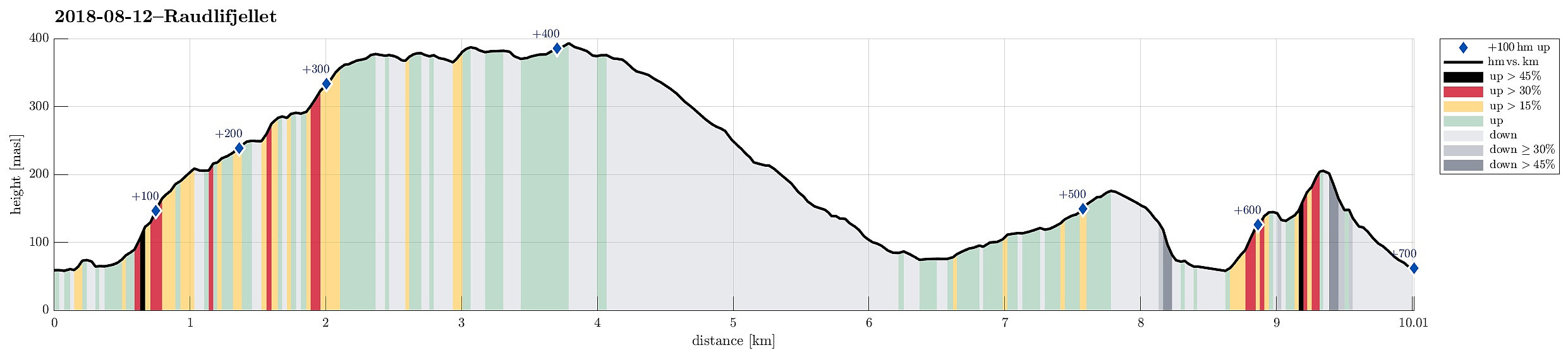
| Duration | 5h 00min |
| Distance | 10.0km |
| Vertical meters | 694m |
| GPS |
|
| Ascents | Nordhordlandskulten (389m) | 12.08.2018 |
|---|---|---|
| Raudlifjellet (395m) | 12.08.2018 | |
| Åsen (181m) | 12.08.2018 | |
| Visits of other PBEs | Hatlelio p-plass (74m) | 12.08.2018 |
| Sælafjellet (374m) | 12.08.2018 |
Note that the descent from Raudlifjellet was without any trail (in the beginning) and thus non-trivial to find.
Trip Summary
We had the (kind of ambitious) plan to walk a round over Nordhordlandskulten, descending to the south from it (even though it was unclear from the consulted maps, whether this should be reasonably doable, given the also quite steep side of the mountain there). To have the car at the right side of the mountain, we parked along Gåssandvegen near a place called Haukeland. The first task was to find the path, which would lead northover in order to bring us to a place from which it would be reasonable to cross over to the main path up to Nordhordlandskulten (the standard approach is from Tømmernes, a little further north). After a little bit of searching, we quickly found the track which leads northwards into Vetlaleitet (a quite nice little valley, in fact!). We then also found the tractor road, leading out of Vetlaleitet (into northeastern direction), and followed this one (steeply up) until we crossed the power line. Even though we could not really find a proper track from there, it still was (kind of) straight-forward to follow the ridge further up. After a while, we connected to the main path and followed this one up the mountain. At Sælafjellet, we then enjoyed some nice views (getting out of the trees, at least for short). Once up there, the path very nicely follows the high ridge of the mountain (mostly there are also trees all around, limiting the views to a certain degree though). Following the path for a bit, we quickly connected to Nordhordlandskulten and looked over Hausdalen from there. We then continued along the ridge and found it more and more difficult to actually find the path. Once passing by Ørnahaugen, we then lost the path completely. From there, it was intuition and landscape reading that lead us downwards from the mountain (in southern direction, i.e., towards Hatlelia). We knew that a bit further down the mountain it would be likely to meet one of the tracks that the maps showed on Raudlia and indeed, once we came down into Fjelldalen, we connected to a path, following it further down. Getting down to Hatlelia was then simple and nice (it does not seem as if a lot of hikers would go there though). At Hatlelia, we split the party (of two) with one going along the road towards our car, while the other one decided to include Åsen "on the way back". To do so, a gravel road was first located at the northeastern end of the mountain. From there, it was then basically "through the bushes", following the long ridge all the way up. This part, after all, is not really recommended as a hike, and you would only do it, if you---for whatever reasons---"need" to get up to Åsen. Once above the top, the continuation became even less friendly: first further along the high ridge before then turning right (and steeply down) through the forest. In order to get back to Gåssandvegen, one needs to consider where to cross the little stream which is running parallel to Gåssandvegen there: the further it gets to the west, the more challenging is it to actually cross it. Since crossing Åsen (through the bushes) took longer than walking along the road, the car was moved to Tømmernes in the meantime. Thus, the slightly more adventurous hiker needed to connect to Tømmernes from Gåssandvegen. The idea was then to "short-cut" the mountain (Nordhordlandskulten/Sælafjellet) on its southwestern end. Quickly this "short-cut" became an adventure by itself, given the steep and demanding topography there (and, of course, the fact that no path would lead the way). After first ascending (steeply) from Gåssandvegen to Rennedalen, the steep terrain required to further ascend (to Vedadalshaugen) in order to actually get over to the other, norther side. Once this was done, however, the rest became simple and straight-forward, given the standard path up to and down from Sælafjellet there.
Photos
Selected photos are available as Google photo album.
Useful Resources
See also the related FB-page Hiking around Bergen, Norway.
Petter Bjørstad has a useful page about Raudlifjellet and also web page WestCoastPeaks.com provides useful information about Raudlifjellet.

User comments