Archive - Date
Archive - Activity
-
Bike trip (4)
- Bike trip - mixed (1)
- Bike trip - off-road (2)
- Bike trip - road (1)
-
Climbing (125)
- Alpine climbing (20)
- Bouldering (2)
- Ice climbing (8)
- Indoor climbing (4)
- Mixed climbing (5)
- Sport climbing (22)
- Via ferrata (57)
- Drive (13)
-
Other trip (20)
- Expedition (7)
- Hunt (1)
- Kayaking (1)
-
Other winter trip (5)
- Alpine skiing (2)
- Snowshoe trip (2)
-
Ski trip (655)
- Backcountry skiing (10)
- Cross-country skiing (17)
- Randonnée/Telemark (624)
-
Trip by foot (1259)
- Alpine trip (409)
- Glacier travel (7)
- Hike (477)
- Hillwalk (300)
- Jogging (15)
- Walk (39)
Archive - Geography
Peakbook-Friends


Collected lists
-
Trondheim ≥ 100m pf.
(20/21)
 95%
95% -
2300m 10m pf. - Stortoppene
(28/30)
93%
-
2000m 30m pf. fastlandet
(162/227)
71%
-
2000m 30m pf.
(162/231)
70%
-
2000m 50m pf.
(130/187)
69%


Favourite trips
- Ekspedisjon Baruntse | Baruntse (7162m)
- Utforsking av den største brebrønnen på
- En variant av den fullstendige Trollatravers
- Italia del 1: Alpene
- La Paz og tre utvalgte høyfjellsturer i
- Vulkanutbrudd på La Palma
- Vinterrangling over Kolås- og Sætretinder
- Alaska 2014
- Glacier Circle og Mt. Dawson i British Columbia
- I det legendariske pudderriket Glacier National
Favourite peaks


Mulig førstebestigning av Tatee Tse (5610m)
- Date:
- 16.11.2025
- Characteristic:
- Alpine trip
- Duration:
- 11:20h
- Distance:
- 14.6km
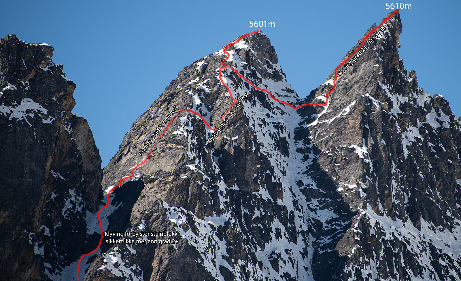 Etter å ha returnert ned til Pangboche etter Ama Dablam satt jeg igjen med å ha lyst på noe mer, samt tid til noe mer. En tanke jeg hadde med meg fra Norge var å vurdere Cholatse (6440m) som en passelig tur å ta alene da den involverer noe mindre risiko enn de øvrige alternativene i umiddelbar nærhet. Angus har vært på Cholatse, og var mer gira på Island Peak, som jeg har vært på to ganger, seinest i fjor så den var ikke like interessant for min del igjen.
Utfordringen denne sesongen er all snøen som kom. Den lå lavt og smeltet ikke noe mer utover i november. I nord, nordvest- og nordøstsektorer lå snøen ned til 4400m, gjerne rundt 50-100cm jevn dybde. Snøen hadde blitt omdannet til en sokkersnøtype eller lett kantkornsnø uten lagdelinger i selve snøen. Det er svært krevende >>>
Etter å ha returnert ned til Pangboche etter Ama Dablam satt jeg igjen med å ha lyst på noe mer, samt tid til noe mer. En tanke jeg hadde med meg fra Norge var å vurdere Cholatse (6440m) som en passelig tur å ta alene da den involverer noe mindre risiko enn de øvrige alternativene i umiddelbar nærhet. Angus har vært på Cholatse, og var mer gira på Island Peak, som jeg har vært på to ganger, seinest i fjor så den var ikke like interessant for min del igjen.
Utfordringen denne sesongen er all snøen som kom. Den lå lavt og smeltet ikke noe mer utover i november. I nord, nordvest- og nordøstsektorer lå snøen ned til 4400m, gjerne rundt 50-100cm jevn dybde. Snøen hadde blitt omdannet til en sokkersnøtype eller lett kantkornsnø uten lagdelinger i selve snøen. Det er svært krevende >>>
