Archiv - Nach Datum
Archiv - Nach Geografie
Peakbookfreunde


Gesammelte Listen
-
Sukkertoppen topper
(90/112)
 80%
80% -
Møre og Romsdal ≥ 500m pf.
(104/161)
64%
-
Møre og Romsdal kommunetopper
(14/24)
58%
-
Sunnmøre ≥ 100m pf.
(294/531)
55%
-
2000m 30m pf. fastlandet
(99/227)
43%


Osmena Peak
- Datum:
- 30.12.2011
- Tourcharakter:
- Wanderung
- Tourlänge:
- 1:28h
- Entfernung:
- 2,0km
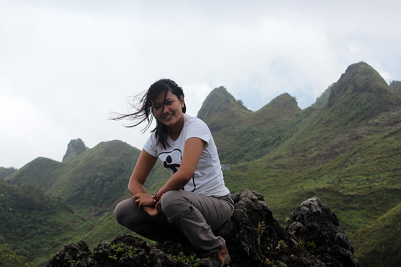 Osmena Peak er med sine ca 1015 meter den høyeste toppen på øya Cebu, den høyeste i provinsen Cebu, og den høyeste i regionen Central Visayas (Region VII). Derfor er dette en meget viktig fjelltopp å få med seg i samlingen til filippinske fjellfolk.
For den som innbiller seg at fjellinteressen i et land som Filippinene må være helt fraværende, kan jeg bare avkrefte dette og henvise til det meget populære nettstedet Pinoymountaineer.com . Legen og fjellfanten Gideon Lasco har nedlagt et fantastisk arbeid med å dokumentere fjell og stier rundtomkring på Filippinene. Det bør også nevnes at Filippinene har flere outdoor-brands, og Habagat er vel det mest anerkjente p.g.a meget god kvalitet til lav pris. Sistnevnte er et must i et land hvor den alminnelige kjøpekraft er en brøkdel av den vestlige.
Fra hotellet >>>
Osmena Peak er med sine ca 1015 meter den høyeste toppen på øya Cebu, den høyeste i provinsen Cebu, og den høyeste i regionen Central Visayas (Region VII). Derfor er dette en meget viktig fjelltopp å få med seg i samlingen til filippinske fjellfolk.
For den som innbiller seg at fjellinteressen i et land som Filippinene må være helt fraværende, kan jeg bare avkrefte dette og henvise til det meget populære nettstedet Pinoymountaineer.com . Legen og fjellfanten Gideon Lasco har nedlagt et fantastisk arbeid med å dokumentere fjell og stier rundtomkring på Filippinene. Det bør også nevnes at Filippinene har flere outdoor-brands, og Habagat er vel det mest anerkjente p.g.a meget god kvalitet til lav pris. Sistnevnte er et must i et land hvor den alminnelige kjøpekraft er en brøkdel av den vestlige.
Fra hotellet >>>
Alto Coloane
- Datum:
- 14.12.2011
- Tourcharakter:
- Wanderung
- Tourlänge:
- 2:08h
- Entfernung:
- 8,1km
 Etter snarvisitten til "nasjonstoppen" Tai Mo Shan i Hong Kong, var mitt neste mål Alto Coloane i Macau. Jeg tok en av de frekvente katamaranene fra Hong Kong (Sheung Wan terminalen) til Macau, en sjøreise på 60 km som gjøres unna på rundt en time. Ettersom Hong Kong og Macau er to forskjellige "nasjoner" må man igjennom immigrasjonen. Dette går heldigvis raskt og smidig på begge sider av grensen (nordmenn trenger ikke visum). Det går helt sikkert busser og tog mellom HK og Macau også, men da må man i såfall gjennom fastlands Kina, hvilket betyr at man trenger visum. Derfor er hurtigbåt helt klart det beste alternativet, selv om prisen er litt høy i asiatisk forstand (ca 150 HKD). Har man god tid finnes det sikkert også saktegående ferger til en brøkdel >>>
Tai Mo Shan
- Datum:
- 13.12.2011
- Tourcharakter:
- Wanderung
- Tourlänge:
- 3:51h
- Entfernung:
- 15,4km
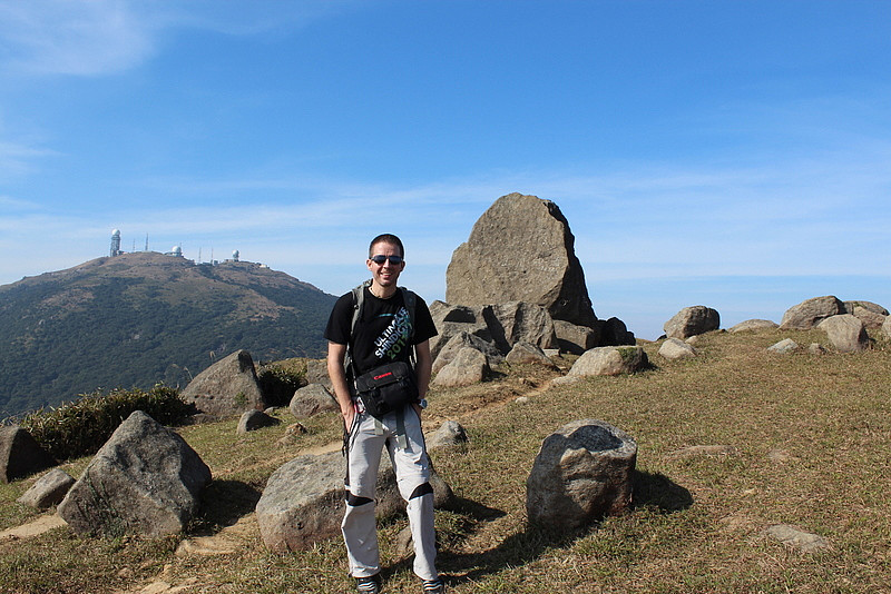 Jeg ankom Hong Kong International Airport rundt midnatt, og besluttet av praktiske årsaker, å tilbringe natten på den flotte flyplassen. Det fantes heldigvis gratis trådløst internett på flyplassen, slik at jeg kunne starte litt detaljplanlegging med hensyn til kollektiv transport til Tai Mo Shan neste morgen. Det ble ikke mye søvn forståelig nok, og allerede kl. 6:00 om morgenen mens det fremdeles var mørkt og kaldt ute, var jeg allerede ombord i den første flybussen til Tsuen Wan (rute A31). Tsuen Wan er en nordlig bydel av Hong Kong, og ligger like ved foten av Tai Mo Shan fjellet. Bussreisen tok ca 1 time og var overraskende billig (19 HKD). Det var nesten ingen andre passasjerer ombord i den 2-etasjers bussen, så hvordan de private busselskapene i Hong Kong tjener penger, forblir >>>
Yushan
- Datum:
- 22.11.2011
- Tourcharakter:
- Wanderung
- Tourlänge:
- 9:13h
- Entfernung:
- 27,0km
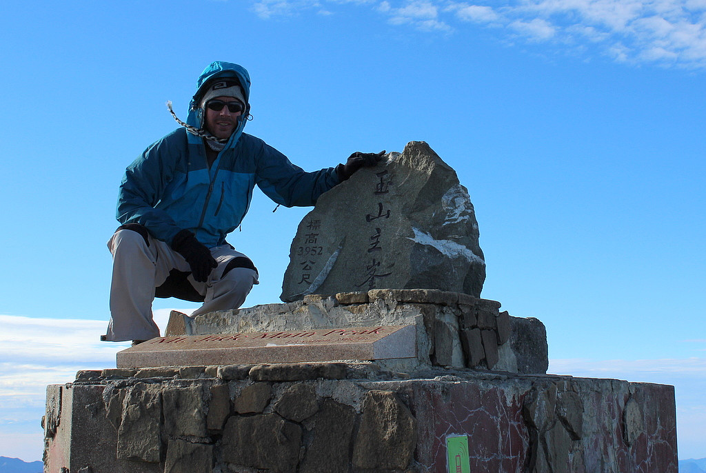 Yushan er med sine 3952 meter det høyeste fjellet på Taiwan. Jeg startet papirmølla bare 3 uker før jeg landet i Taiwan, og med veldig knapp margin, fikk jeg tillatelsene (park permit + mountain permit) oversendt på e-mail bare et par dager før jeg satte meg på et billigfly fra Manila til Taipei (900 NOK t/r). Tillatelsene koster ikke fem øre, men man må påregne noen småutgifter til porto for å sende den orginale og undertegnede søknaden med DHL, FedEx, LBC Express eller hvis man har god tid, Posten. Jeg sendte den med LBC Express fra Manila, det tok 4 dager og kostet en hundrelapp.
Jeg ankom Taoyuan International Airport midt på natten med feber og forkjølelse, men helsepersonellet på flyplassen oppdaget heldigvis ikke dette på skjermen sin (ettersom jeg hadde tatt et par febersenkende >>>
Yushan er med sine 3952 meter det høyeste fjellet på Taiwan. Jeg startet papirmølla bare 3 uker før jeg landet i Taiwan, og med veldig knapp margin, fikk jeg tillatelsene (park permit + mountain permit) oversendt på e-mail bare et par dager før jeg satte meg på et billigfly fra Manila til Taipei (900 NOK t/r). Tillatelsene koster ikke fem øre, men man må påregne noen småutgifter til porto for å sende den orginale og undertegnede søknaden med DHL, FedEx, LBC Express eller hvis man har god tid, Posten. Jeg sendte den med LBC Express fra Manila, det tok 4 dager og kostet en hundrelapp.
Jeg ankom Taoyuan International Airport midt på natten med feber og forkjølelse, men helsepersonellet på flyplassen oppdaget heldigvis ikke dette på skjermen sin (ettersom jeg hadde tatt et par febersenkende >>>
Alto Peak
- Datum:
- 20.10.2011
- Tourcharakter:
- Wanderung
- Tourlänge:
- 10:14h
- Entfernung:
- 16,5km
 Før vi ankom Ormoc City på Filippinene hadde vi utforsket litt om Alto Peak (1330m), som er høyeste fjelltopp i Eastern Visayas. På lokalt folkemunne er denne toppen bedre kjent som Mt. Mindieun. Et par kilder vi hadde vært i kontakt med, var imidlertid svært negative til Alto Peak p.g.a NPA (maoist) aktivitet i området. For et drøyt år siden hadde en uskyldig botanist blitt skutt ned og drept i dette vakre og ville fjellandskapet. Militæret hadde visstnok forvekslet ham med en NPA aktivist. Skyt først og spør etterpå ser ut til å være lokal sedvane her, så militæret kan faktisk vise seg å være en større trussel enn maoistene (NPA). Bl.a.har en del vandrere rapportert at de har opplevd å blitt "siktet på" med skarpe våpen av militæret, ja endog forsøkt å >>>
Jabal ad Dukhan
- Datum:
- 02.10.2011
- Tourcharakter:
- Wanderung
- Tourlänge:
- 0:49h
- Entfernung:
- 2,4km
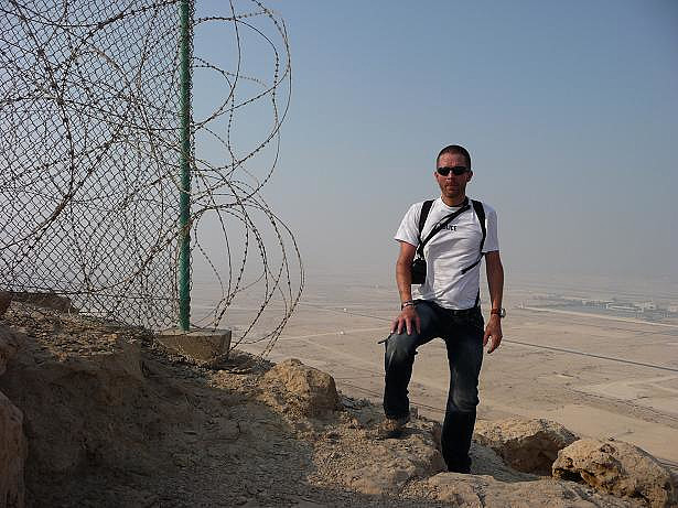 I did this trip together with Lars. See all the external links from our trip below:
- See all my photos from Bahrain
- Trip report on wwv.no (norwegian text by Lars Holme)
- GPS-track from the drive to Jabal Dukhan
- GPS-track from the hike
I did this trip together with Lars. See all the external links from our trip below:
- See all my photos from Bahrain
- Trip report on wwv.no (norwegian text by Lars Holme)
- GPS-track from the drive to Jabal Dukhan
- GPS-track from the hike
Qatar HP
- Datum:
- 02.10.2011
- Tourcharakter:
- Wanderung
- Tourlänge:
- 0:45h
- Entfernung:
- 3,2km
 I did this trip together with Lars. See all the external links from our trip below:
- See all my photos from Qatar
- Trip report on wwv.no (norwegian text by Lars Holme)
- GPS-track from Doha to trailhead (drive)
- GPS-track from the hike
I did this trip together with Lars. See all the external links from our trip below:
- See all my photos from Qatar
- Trip report on wwv.no (norwegian text by Lars Holme)
- GPS-track from Doha to trailhead (drive)
- GPS-track from the hike
