Archiv - Nach Datum
Archiv - Nach Aktivität
-
Andere Tour (3)
- Kayaking (3)
-
Fahrradtour (107)
- Fahrradtour Straße (82)
- Fahrradtour gemischt (25)
-
Fahrzeugtour (9)
- Autotour (9)
-
Fußtour (1747)
- Bergtour (1034)
- Jogging (1)
- Spaziergang (52)
- Wanderung (660)
-
Skitour (109)
- Langlauf (44)
- Tourenskilauf (65)
Gesammelte Listen
-
Utvalgte topper og turmål i Bergen
(332/333)
 99%
99% -
Alle topper i Bergen
(379/386)
98%
-
Kvam ≥ 100m pf.
(41/44)
93%
-
Opptur Hordaland
(143/159)
89%
-
Voss ≥ 100m pf.
(86/98)
87%
-
Stasjoner på Bergensbanen
(28/36)
77%
-
Hordaland ≥ 100m pf.
(593/863)
68%
-
Ulvik ≥ 100m pf.
(26/38)
68%
-
Jondal ≥ 100m pf.
(15/23)
65%
-
Dagsturhyttene i Vestland
(33/61)
54%
-
Sunnhordland PF >= 100m
(100/186)
53%
-
DNT-hytter i Hordaland
(22/45)
48%
-
Hordaland: Hardanger PF>=100m
(170/359)
47%
-
Kvinnherad ≥ 100m pf.
(36/79)
45%
-
Sogndal ≥ 100m pf.
(23/81)
28%
-
DNT-hytter i Sogn og Fjordane
(8/47)
17%
-
Eidfjord ≥ 100m pf.
(6/42)
14%
-
Etne ≥ 100m pf.
(7/51)
13%
-
Ullensvang ≥ 100m pf.
(19/153)
12%
-
Opptur i Sogn og Fjordane peaks
(17/177)
9%

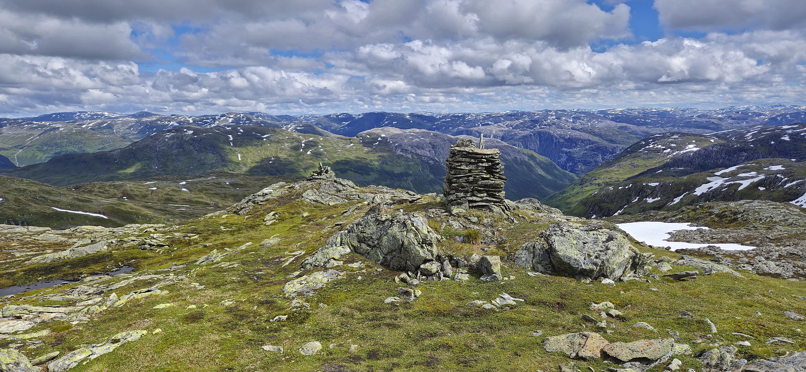
Kjøroldenuten and Nosafjellet from Fresvikjordalen
- Datum:
- 09.11.2024
- Tourcharakter:
- Bergtour
- Tourlänge:
- 3:55h
- Entfernung:
- 9,5km
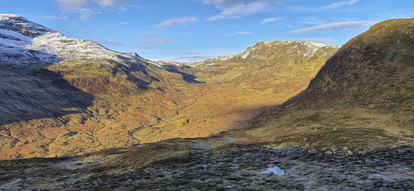 For the first hike with Petter in half a year, we drove to Jordalen in Voss/Vik to visit three summits that none us had yet ascended. First up was Kjøroldenuten . In order to get as close to the summit as possible, we paid the 50 kr road toll and continued up to Nedstedalen in Fresvikjordalen. Here we found parking next to the road and had easy access to the other side of the river via a bridge I had located on the map .
After crossing the bridge we simply made our own way to the valley south of Kjøroldenuten and from there completed the short remaining ascent to the summit. This last part was steeper but did not present any real challenges. We however did not stay long before turning the attention to our next goal: Nosafjellet .
Following the ridge south from Kjøroldenuten towards Nosafjellet included some up and down but was overall straightforward. The only challenge >>>
For the first hike with Petter in half a year, we drove to Jordalen in Voss/Vik to visit three summits that none us had yet ascended. First up was Kjøroldenuten . In order to get as close to the summit as possible, we paid the 50 kr road toll and continued up to Nedstedalen in Fresvikjordalen. Here we found parking next to the road and had easy access to the other side of the river via a bridge I had located on the map .
After crossing the bridge we simply made our own way to the valley south of Kjøroldenuten and from there completed the short remaining ascent to the summit. This last part was steeper but did not present any real challenges. We however did not stay long before turning the attention to our next goal: Nosafjellet .
Following the ridge south from Kjøroldenuten towards Nosafjellet included some up and down but was overall straightforward. The only challenge >>>
Store Ishaug, Trælhaug, Vetle Ishaug and Svolnos
- Datum:
- 21.09.2024
- Tourcharakter:
- Bergtour
- Tourlänge:
- 7:54h
- Entfernung:
- 23,8km
 When Endre asked if I wanted to spend the upcoming Saturday hiking in Eidfjord, I of course immediately said yes and we decided on the area between Måbødalen and Simdalen as our target area, as it contained up to five peaks that neither of us had yet visited. Endre therefore picked me up at my place shortly after 08:00 on the Saturday morning and we started our drive to Eidfjord in an unusually dense fog that we could not escape until beginning the ascent up Måbødalen.
We parked at the large parking lot along Isdalsvegen and from there followed a trail through a cabin area before connecting with the marked trail to Simadal. Even though it was already late September, the weather was very warm and I soon had to make a stop to change into shorts, and the rest of the hike was carried out in just shorts and t-shirts for both of us.
Near >>>
When Endre asked if I wanted to spend the upcoming Saturday hiking in Eidfjord, I of course immediately said yes and we decided on the area between Måbødalen and Simdalen as our target area, as it contained up to five peaks that neither of us had yet visited. Endre therefore picked me up at my place shortly after 08:00 on the Saturday morning and we started our drive to Eidfjord in an unusually dense fog that we could not escape until beginning the ascent up Måbødalen.
We parked at the large parking lot along Isdalsvegen and from there followed a trail through a cabin area before connecting with the marked trail to Simadal. Even though it was already late September, the weather was very warm and I soon had to make a stop to change into shorts, and the rest of the hike was carried out in just shorts and t-shirts for both of us.
Near >>>
Framnes to Vinje via Tverrfjellet/Fossanipa
- Datum:
- 14.09.2024
- Tourcharakter:
- Bergtour
- Tourlänge:
- 5:24h
- Entfernung:
- 17,1km
 After taking the train from Bergen to Voss and the bus to Oppheim, I got off at Framnes at the southwestern end of Oppheimsvatnet. From there I headed north via Bidne to Svorto. The ascent followed a paved road that gradually turned into a rough tractor road and finally ended up as more of a muddy path.
The map indicates a trail heading north/northwest from Svorto, but while I did find an unmarked trail, it was quite weak and I therefore lost it several times. By the time I got close to Såta the trail had completely disappeared and I was left with finding my own way. Såta provided great views and even had its own visitor register.
From Såta I made my own way north to the main goal of the day: Tverrfjellet . No trails here as far as I could tell but the terrain was easy to navigate. I made a couple of minor >>>
After taking the train from Bergen to Voss and the bus to Oppheim, I got off at Framnes at the southwestern end of Oppheimsvatnet. From there I headed north via Bidne to Svorto. The ascent followed a paved road that gradually turned into a rough tractor road and finally ended up as more of a muddy path.
The map indicates a trail heading north/northwest from Svorto, but while I did find an unmarked trail, it was quite weak and I therefore lost it several times. By the time I got close to Såta the trail had completely disappeared and I was left with finding my own way. Såta provided great views and even had its own visitor register.
From Såta I made my own way north to the main goal of the day: Tverrfjellet . No trails here as far as I could tell but the terrain was easy to navigate. I made a couple of minor >>>
Cycling: Rallarvegen and Austre Låghellerhøgdene
- Datum:
- 01.09.2024
- Tourcharakter:
- Fahrradtour gemischt
- Tourlänge:
- 4:59h
- Entfernung:
- 40,7km
 To take full advantage the warm and sunny weather, I decided to combine a bike ride along Rallarvegen with a visit of Austre Låghellerhøgdene . I had rented a bike in advance which I picked up at Finse after arriving by train from Bergen. Shortly, I was on the bike and cycling northwest along the overall good quality gravel road.
After passing the highest point at Rallarvegen (at 1343 meters) I descended towards Fagernut . Just before getting to the cabin, I left the bike behind for a short off-trail hike to the summit of Austre Låghellerhøgdene. The ascent was straightforward, however finding the exact summit was more tricky with three minor hills to choose from. As usual, I simply visited all of them, before descending along more or less the same route.
Back on the bike, I made a short stop outside Fagernut before continuing on the gravel road to Hallingskeid. >>>
To take full advantage the warm and sunny weather, I decided to combine a bike ride along Rallarvegen with a visit of Austre Låghellerhøgdene . I had rented a bike in advance which I picked up at Finse after arriving by train from Bergen. Shortly, I was on the bike and cycling northwest along the overall good quality gravel road.
After passing the highest point at Rallarvegen (at 1343 meters) I descended towards Fagernut . Just before getting to the cabin, I left the bike behind for a short off-trail hike to the summit of Austre Låghellerhøgdene. The ascent was straightforward, however finding the exact summit was more tricky with three minor hills to choose from. As usual, I simply visited all of them, before descending along more or less the same route.
Back on the bike, I made a short stop outside Fagernut before continuing on the gravel road to Hallingskeid. >>>
Hanakamb from Kvitno
- Datum:
- 11.08.2024
- Tourcharakter:
- Bergtour
- Tourlänge:
- 5:09h
- Entfernung:
- 9,0km
 Sunday hike to Hanakamb organized by Voss Utferdslag . I started by taking an early train to Voss where I met up with the other hikers for the drive to Kvitno via the ferry from Kvanndal to Utne. Upon arriving at the trailhead the small parking lot with room for perhaps 2-3 cars was already full and we therefore parked on the other side of the road (although this is probably more of a bus stop, i.e. be prepared for potential parking tickets if going for this option).
After a shortcut from the marked trailhead we passed by Kvitno kraftverk and continued on a tractor road up to the start of the marked trail just where the road came to an end. A steep and sometimes slippery trail then took us up to the beautiful Raunsdalsvatnet. This section was overall straightforward but one should pay extra care towards the end where >>>
Sunday hike to Hanakamb organized by Voss Utferdslag . I started by taking an early train to Voss where I met up with the other hikers for the drive to Kvitno via the ferry from Kvanndal to Utne. Upon arriving at the trailhead the small parking lot with room for perhaps 2-3 cars was already full and we therefore parked on the other side of the road (although this is probably more of a bus stop, i.e. be prepared for potential parking tickets if going for this option).
After a shortcut from the marked trailhead we passed by Kvitno kraftverk and continued on a tractor road up to the start of the marked trail just where the road came to an end. A steep and sometimes slippery trail then took us up to the beautiful Raunsdalsvatnet. This section was overall straightforward but one should pay extra care towards the end where >>>
Jonahornet, Tofjellet, Gulbergnotten and Vikanuten
- Datum:
- 01.08.2024
- Tourcharakter:
- Bergtour
- Tourlänge:
- 8:22h
- Entfernung:
- 19,7km
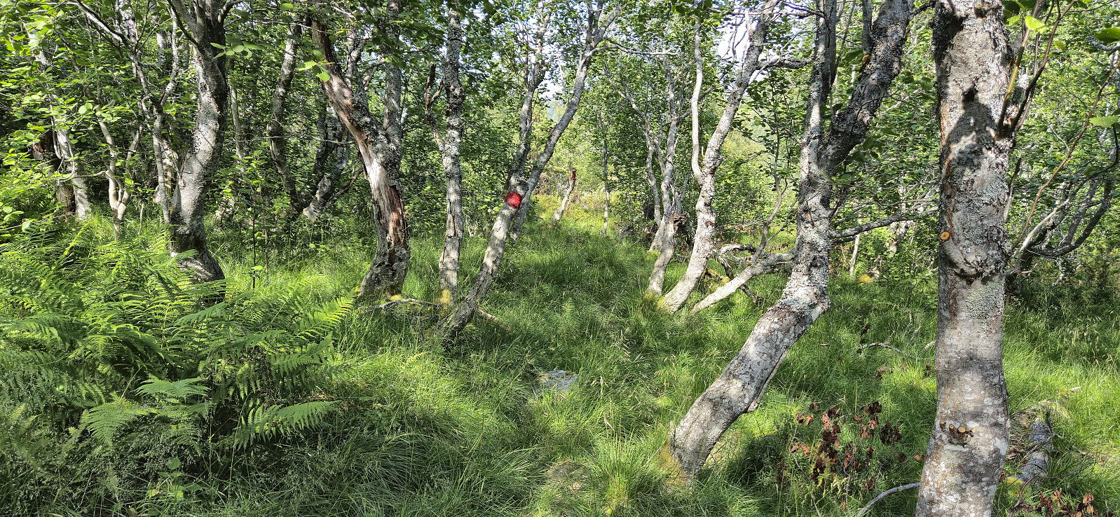
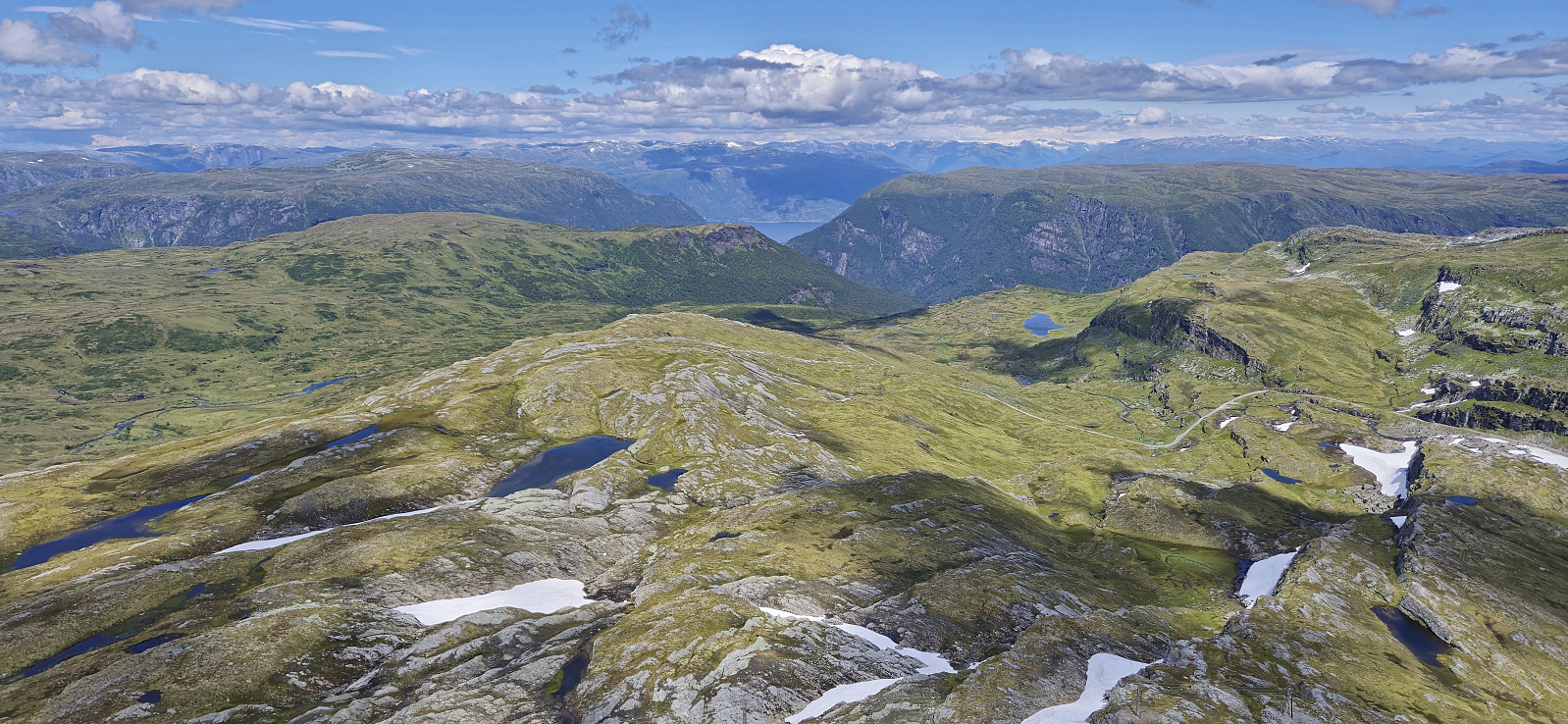
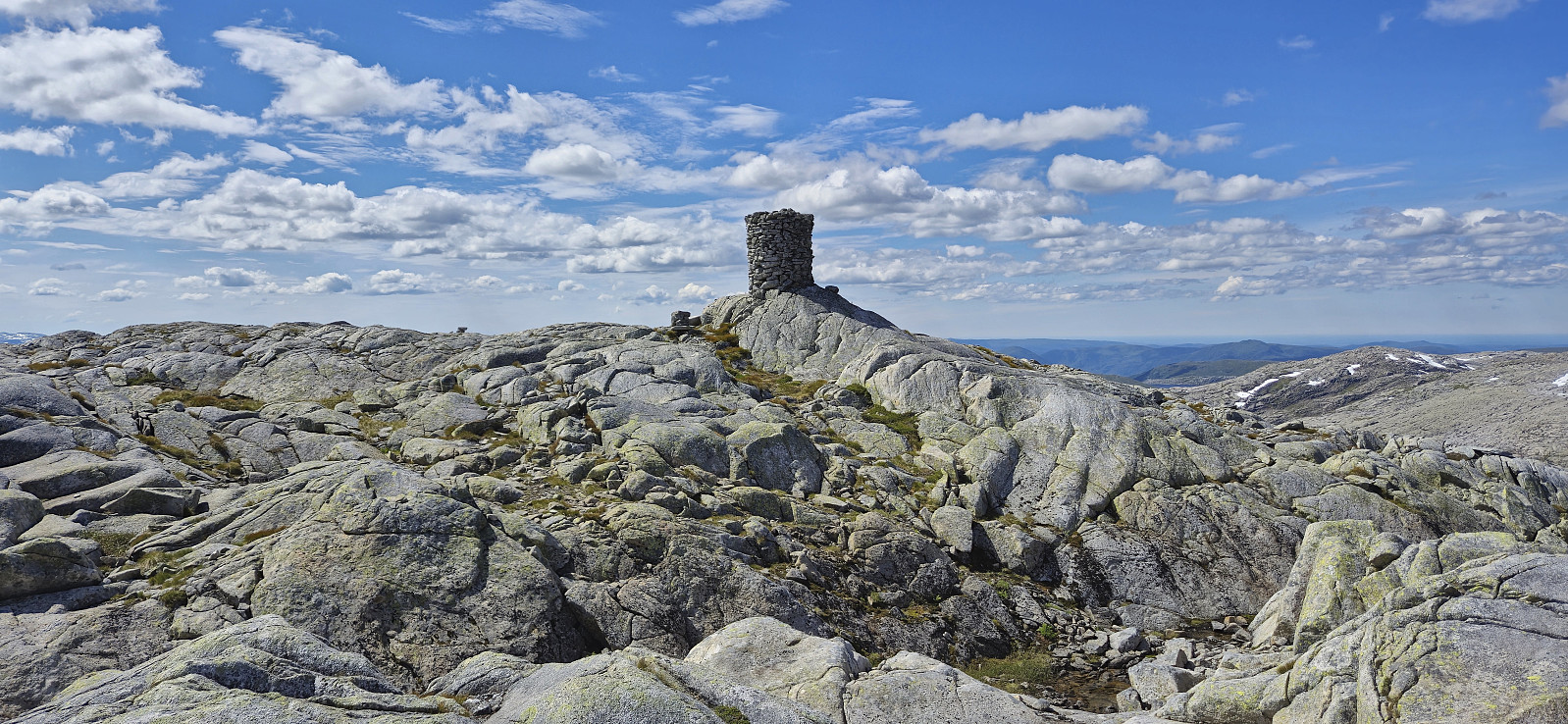
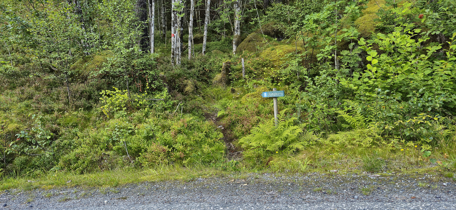 A hike to the three peaks just north of Jondal had been on my radar for a while. Ideally, I would like to start from the north and hike via the three peaks on my way to Jondal. Getting to the trailhead at Selsvik by public transport is however difficult. Or so I had thought. But based on my recent success of using the express boat from Norheimsund to visit Grimsnuten , I figured out that it should be possible to do something similar here as well. After a bit of digging I even found out that there is a corresponding bus from Herand towards Jondal that would get me to the wanted starting location and thus leave room for a potential bonus peak before taking the ferry and bus home from Jondal.
I therefore once more took the bus to Norheimsund and then the express boat, but this time getting off at Herand. A short bus ride later I arrived at the main road >>>
A hike to the three peaks just north of Jondal had been on my radar for a while. Ideally, I would like to start from the north and hike via the three peaks on my way to Jondal. Getting to the trailhead at Selsvik by public transport is however difficult. Or so I had thought. But based on my recent success of using the express boat from Norheimsund to visit Grimsnuten , I figured out that it should be possible to do something similar here as well. After a bit of digging I even found out that there is a corresponding bus from Herand towards Jondal that would get me to the wanted starting location and thus leave room for a potential bonus peak before taking the ferry and bus home from Jondal.
I therefore once more took the bus to Norheimsund and then the express boat, but this time getting off at Herand. A short bus ride later I arrived at the main road >>>
Grimsnuten from Utne
- Datum:
- 29.07.2024
- Tourcharakter:
- Bergtour
- Tourlänge:
- 6:45h
- Entfernung:
- 16,1km
 I had initially planned to visit Grimsnuten via the ferry from Kvanndal to Utne, but when discovering that during the summer there is an express boat from Norheimsund I concluded that this would be an even better option. After starting by taking the bus from Bergen I therefore switched to the express boat at Norheimsund and could enjoy excellent views from the fjord for about 55 minutes before arriving at Utne. (Note that there is only a 10-minute transfer window in Norheimsund, hence one has to hope that the bus is on time. We were only around four minutes late and thus made the boat without any issues.)
Upon arriving at Utne I followed in the footsteps of Rune Blomberg and his trip report from 2012 . This made it straightforward to locate the marked trailhead after a short walk along the paved road and a much shorter walk along a gravel road. The sign at the trailhead >>>
I had initially planned to visit Grimsnuten via the ferry from Kvanndal to Utne, but when discovering that during the summer there is an express boat from Norheimsund I concluded that this would be an even better option. After starting by taking the bus from Bergen I therefore switched to the express boat at Norheimsund and could enjoy excellent views from the fjord for about 55 minutes before arriving at Utne. (Note that there is only a 10-minute transfer window in Norheimsund, hence one has to hope that the bus is on time. We were only around four minutes late and thus made the boat without any issues.)
Upon arriving at Utne I followed in the footsteps of Rune Blomberg and his trip report from 2012 . This made it straightforward to locate the marked trailhead after a short walk along the paved road and a much shorter walk along a gravel road. The sign at the trailhead >>>
Urdeggi, Skjelinganosi and Skabotsvarden
- Datum:
- 23.07.2024
- Tourcharakter:
- Bergtour
- Tourlänge:
- 6:16h
- Entfernung:
- 18,7km
 For the second time this summer I hitched a ride to Vikafjellet where I was dropped off at Nordre Skjelingen and could start my ascent of Urdeggi via the gravel road between the cabins. After passing the final cabin I found my own way to the summit. This was straightforward and the summit provided spectacular views.
From Urdeggi I first walked south on a trail along the ridge, but later headed more directly to the gravel road to the southwest to begin my ascent of Skjelinganosi . The ascent looked steep from a distance but turned out to be a marked trail with small cairns leading the way. Once more the views were impressive, especially near the steep north face.
After a short lunch break, I headed south/southwest via Skjelinganosi Sør to Skabotsvarden . No trails here as far as I could tell but the terrain was easy to traverse and did not present >>>
For the second time this summer I hitched a ride to Vikafjellet where I was dropped off at Nordre Skjelingen and could start my ascent of Urdeggi via the gravel road between the cabins. After passing the final cabin I found my own way to the summit. This was straightforward and the summit provided spectacular views.
From Urdeggi I first walked south on a trail along the ridge, but later headed more directly to the gravel road to the southwest to begin my ascent of Skjelinganosi . The ascent looked steep from a distance but turned out to be a marked trail with small cairns leading the way. Once more the views were impressive, especially near the steep north face.
After a short lunch break, I headed south/southwest via Skjelinganosi Sør to Skabotsvarden . No trails here as far as I could tell but the terrain was easy to traverse and did not present >>>
Bergsdalen to Eikedalen
- Datum:
- 13.07.2024
- Tourcharakter:
- Bergtour
- Tourlänge:
- 9:11h
- Entfernung:
- 29,2km
 For the second Saturday in a row I took the train to Dale and the bus to Bergsdalen, but where I last week walked north to Evanger , this time I was heading south to Eikedalen. I got off the bus at the start of the road to Raunehaugen where I soon located the unmarked trailhead for Kjerringafjellet . The trail quality varied quite a lot and except for small cairns (mainly) towards the end it was unmarked. At several points I therefore had to check the GPS to make sure I was heading the right way. Near the summit there was also a boulder obstacle course that had to be traversed. The summit provided great views and a nice location for a short lunch break.
In order to next go to Storliknausen I first returned north towards Såta before carefully navigating my way down to the valley between Kjerringafjellet and Storliknausen. This was overall straightforward, >>>
For the second Saturday in a row I took the train to Dale and the bus to Bergsdalen, but where I last week walked north to Evanger , this time I was heading south to Eikedalen. I got off the bus at the start of the road to Raunehaugen where I soon located the unmarked trailhead for Kjerringafjellet . The trail quality varied quite a lot and except for small cairns (mainly) towards the end it was unmarked. At several points I therefore had to check the GPS to make sure I was heading the right way. Near the summit there was also a boulder obstacle course that had to be traversed. The summit provided great views and a nice location for a short lunch break.
In order to next go to Storliknausen I first returned north towards Såta before carefully navigating my way down to the valley between Kjerringafjellet and Storliknausen. This was overall straightforward, >>>
Bjørndalskamben and Sollifjellet
- Datum:
- 09.07.2024
- Tourcharakter:
- Bergtour
- Tourlänge:
- 6:53h
- Entfernung:
- 18,3km
 I was lucky to hitch a ride to Kvassdalen and was dropped off next to the unmarked trailhead for Bjørndalen . The first part of the ascent looked very steep but thanks to earlier trip reports, e.g. Arnt 's external trip report , I was pretty sure that it would be ok. As expected, the trail was steep but did not present any real challenges, although it may not be for everyone due to a couple of semi-exposed sections.
After the initial steep ascent, the terrain levelled off and I followed a nice trail along the river to Bjørndalen for the first look at Bjørndalskamben . The trail continued south, I however made a detour for better views into Kvassdalen. Upon reconnecting with the trail I did not stay on it for long and instead followed various sheep tracks. There were occasional cairns but no trail as far as I could tell. Closer to the summit, >>>
I was lucky to hitch a ride to Kvassdalen and was dropped off next to the unmarked trailhead for Bjørndalen . The first part of the ascent looked very steep but thanks to earlier trip reports, e.g. Arnt 's external trip report , I was pretty sure that it would be ok. As expected, the trail was steep but did not present any real challenges, although it may not be for everyone due to a couple of semi-exposed sections.
After the initial steep ascent, the terrain levelled off and I followed a nice trail along the river to Bjørndalen for the first look at Bjørndalskamben . The trail continued south, I however made a detour for better views into Kvassdalen. Upon reconnecting with the trail I did not stay on it for long and instead followed various sheep tracks. There were occasional cairns but no trail as far as I could tell. Closer to the summit, >>>
